 Earthquake OFF COAST OF CALIFORNIA Earthquake OFF COAST OF CALIFORNIA
 |
 |
Preferred Hypocentral Solution:
 |
 |
| Local Date: |
Sunday October 16th, 2005 |
| Local Time: |
02:11 PM PDT |
| Universal Time: |
10/16/2005 21:11:34.000 UTC |
| Magnitude: |
4.88 ML |
| Latitude: |
32.4210 |
| Longitude: |
-118.1723 |
| Depth: |
4 miles (6 km) |
| Author: |
CalTech |
| Authoritative: |
Yes |
|
|
 |
Alternate Hypocentral Solution:
|
|
| Local Date: |
Sunday October 16th, 2005 |
| Local Time: |
02:11 PM PDT |
| Universal Time: |
10/16/2005 21:11:35.000 UTC |
| Magnitude: |
4.70 Mb |
| Latitude: |
32.5280 |
| Longitude: |
-118.0720 |
| Depth: |
3 miles (5 km) |
| Author: |
USGS |
| Authoritative: |
Yes |
|
|
|
Alternate Hypocentral Solution:
|
|
| Local Date: |
Sunday October 16th, 2005 |
| Local Time: |
02:11 PM PDT |
| Universal Time: |
10/16/2005 21:11:32.660 UTC |
| Magnitude: |
4.98 ML |
| Latitude: |
32.2117 |
| Longitude: |
-118.2110 |
| Depth: |
10 miles (16 km) |
| Author: |
Default |
| Authoritative: |
No |
|
|
|
Alternate Hypocentral Solution:
|
|
| Local Date: |
Sunday October 16th, 2005 |
| Local Time: |
02:11 PM PDT |
| Universal Time: |
10/16/2005 21:11:35.497 UTC |
| Magnitude: |
4.89 ML |
| Latitude: |
32.5154 |
| Longitude: |
-118.1361 |
| Depth: |
14 miles (22 km) |
| Author: |
UCSD Personnel |
| Authoritative: |
No |
|
|
|
Alternate Hypocentral Solution:
|
|
| Local Date: |
Sunday October 16th, 2005 |
| Local Time: |
02:11 PM PDT |
| Universal Time: |
10/16/2005 21:11:35.200 UTC |
| Magnitude: |
4.70 Mb |
| Latitude: |
32.5260 |
| Longitude: |
-118.0730 |
| Depth: |
3 miles (5 km) |
| Author: |
USGS |
| Authoritative: |
Yes |
|
|
|
 |
|
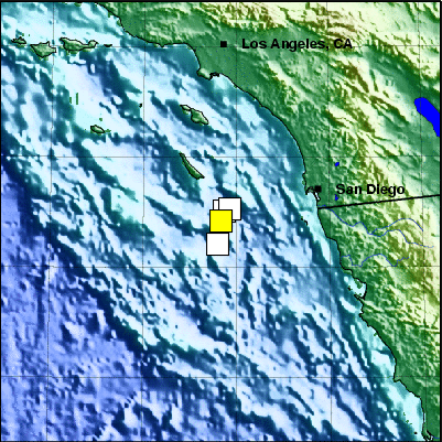
| 65 miles (104 km) WSW of San Diego |
| 112 miles (179 km) S of Los Angeles, CA |
|
|
 |
Credits:
Wessel and Smith's Generic Mapping Tools
Sandwell/Smith Marine Bathymetry
USGS GTOPO30 topography database
NOAA/NGDC Arctic Bathymetry
Lindquist Consulting
|