
Magnitude 4.0 quake near Julian, CA
Last updated: 2018-03-26 17:50:58 UTC
Quick Links
- Location map
- Initial source parameters
- 3 components [closest Anza station]
- Vertical components [all Anza stations]
![3 components [closest Anza station]](3comp_vert.gif)
![Vertical components [all Anza stations]](AZ_verts.gif)
Translations
![]()
![]()
![]()
![]()
![]()
![]()
![]()
![]()
![]()
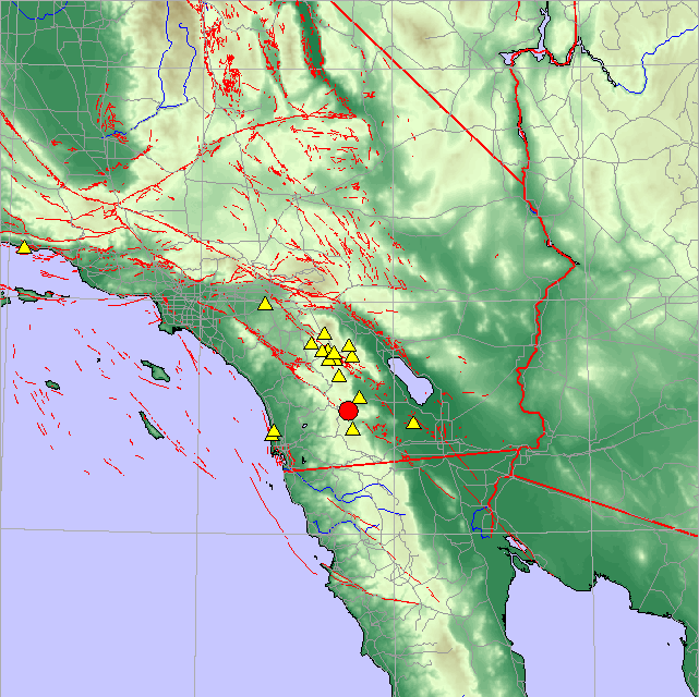
The Anza group at the University of California San Diego operates a broadband seismograph network consisting of 13 (+ 2) three component broadband seismograph stations centered near Anza Californa (see map).
On Sunday, February 2nd, 2002 at 20:39 (PST) we recorded a quake (preliminary ml 4.0) located near the town of Julian.
If felt the quake, USGS would like to know. Add to the USGS "Did you feel it?" page.
View the most recent map of local events near San Diego or a map of events recoded by ANZA from around the globe.
We also have a bulletin of recent events recorded by the Anza network.
Initial source parameters for the recent event and aftershocks are shown below. The epicentral distance (distance separating the epicenter and the closest station in the recording network) for ANZA is 0.174 degrees (19.4 km). The distance from San Diego is approximately 77km.
The map below shows the mainshock (red circle). ANZA network stations are yellow triangles. The closest station to the event was MONP (Monument Peak).
| Latitute | Longitude | Origin time (UTC) | Depth | ml | Author |
|---|---|---|---|---|---|
| 33.0626 | -116.4650 | 2/04/2002 (035) 04:39:09.363 | 17.204km | 4.06* | UCSD |
*note that the location and magnitude determined for this event is preliminary and is subject to change upon further review of seismic data.
You may view a plot showing
Learn more about the Anza group (including who works here, other networks, nuclear tests in China/India/Pakistan).
Learn more about the ANZA network (includes more station information, research, etc).
URL: http://eqinfo.ucsd.edu/special_events/2002/034/a/index.php [Last updated: 2018-03-26 17:50:58 UTC]