
last update to page: June 07 2016 17:09:38 (UTC).
SummaryThe red marker denotes the earthquake epicenter. On Tue Jun 7th 2016 10:51:38 (UTC) the seismic network recorded an earthquake (preliminary 6.2 mwp) located in Off Coast Of Jalisco, Mexico. Seismic region Mexico - Guatemala Area. The epicentral distance (i.e. distance separating the location to the epicenter) to the closest station USGCB in the network is 1,957.2 km. If you felt the quake, the USGS would like to know. Please add your comments to the USGS page "Did you feel it?". |
Details
Proximity to Population Centers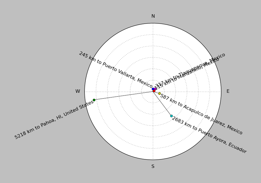
| ||||||||||||||||
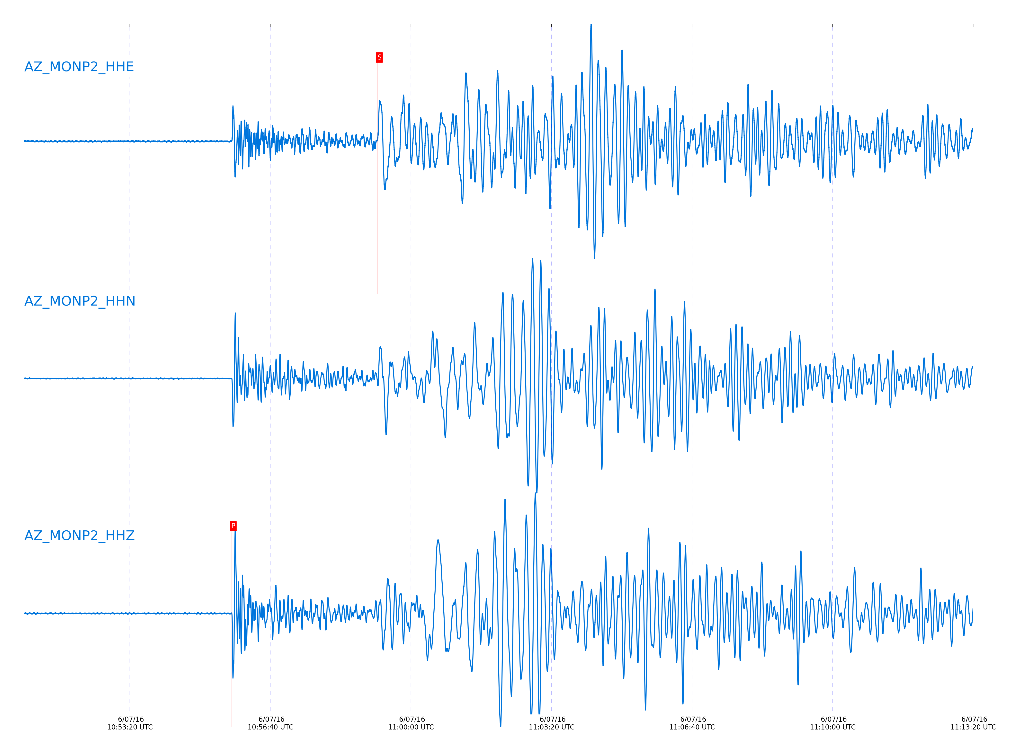
Event and active stations
|
|||||||||||||||||
Closest station with identified signal. Not filtered.
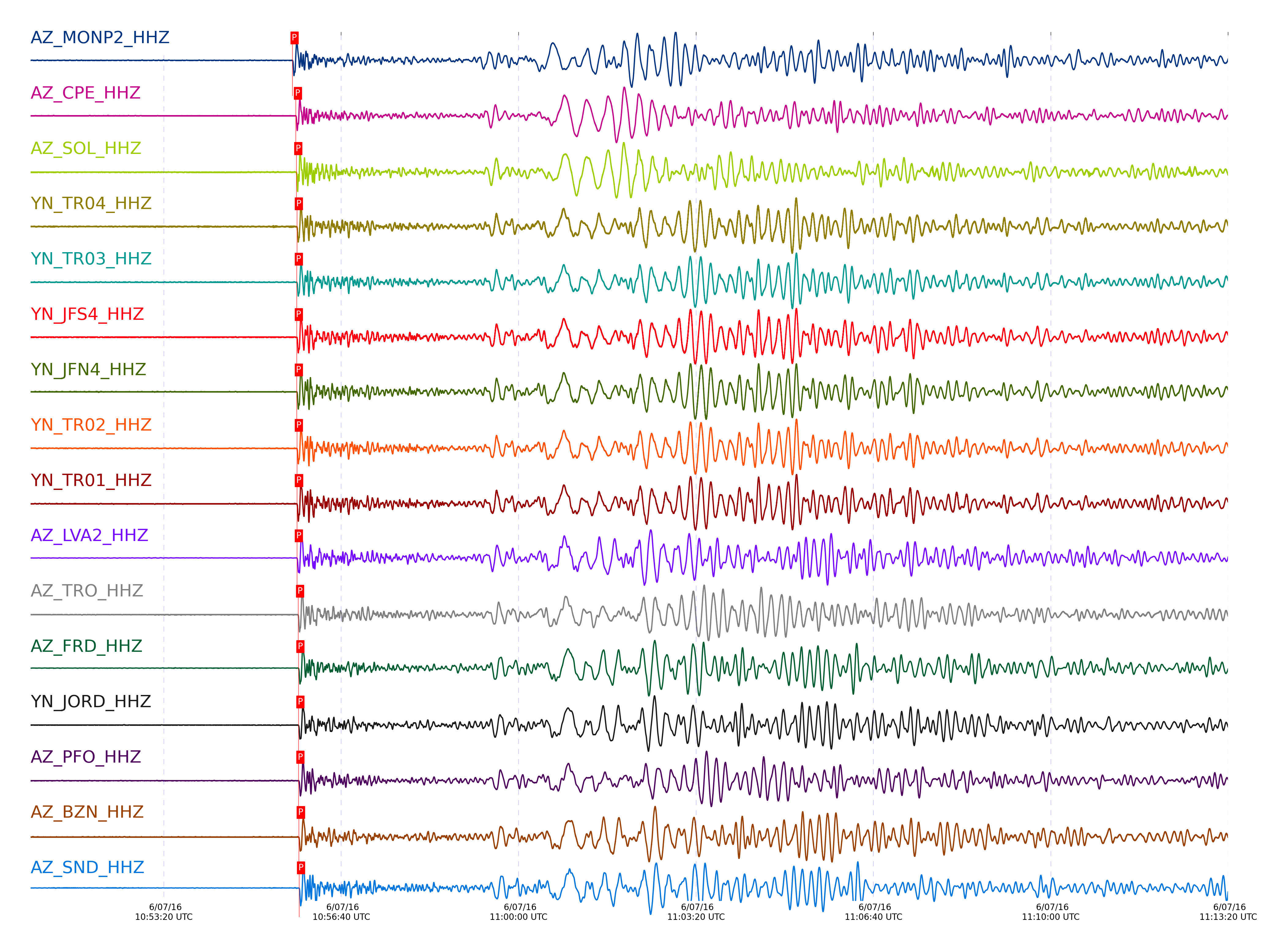
Subset of several stations close to the event. Not filtered.
| STA_CHAN | S-E Delta | S-E Azimuth | Phase | Time | Signal/Noise | Time Residual | V. Model | Auth | arid |
|---|---|---|---|---|---|---|---|---|---|
| MONP2_HHZ | 17.642° | 142.41° | P | 2016-06-07 10:55:45.1159 UTC | -1 | 0.064 | iasp91 | dbp:jtytell:161 | 1029671 |
| MONP2_HHE | 17.642° | 142.41° | S | 2016-06-07 10:59:12.6708 UTC | -1 | 3.632 | iasp91 | dbp:jtytell:161 | 1029724 |
| CPE_HHZ | 17.996° | 140.64° | P | 2016-06-07 10:55:48.944 UTC | 138.03 | -0.019 | iasp91 | dbp:jtytell:161 | 1029367 |
| CPE_HHE | 17.996° | 140.64° | S | 2016-06-07 10:59:17.5266 UTC | -1 | 1.271 | iasp91 | dbp:jtytell:161 | 1029733 |
| SOL_HHZ | 18.036° | 140.19° | P | 2016-06-07 10:55:49.4372 UTC | 79.235 | 0.038 | iasp91 | dbp:jtytell:161 | 1029369 |
| SOL_HHE | 18.036° | 140.19° | S | 2016-06-07 10:59:18.7332 UTC | -1 | 1.672 | iasp91 | dbp:jtytell:161 | 1029734 |
| TR04_HHZ | 18.048° | 143.35° | P | 2016-06-07 10:55:50.1235 UTC | -1 | 0.59 | iasp91 | dbp:jtytell:161 | 1029683 |
| TR04_HHE | 18.048° | 143.35° | S | 2016-06-07 10:59:22.4805 UTC | -1 | 5.173 | iasp91 | dbp:jtytell:161 | 1029735 |
| TR03_HHZ | 18.055° | 143.38° | P | 2016-06-07 10:55:49.9863 UTC | -1 | 0.373 | iasp91 | dbp:jtytell:161 | 1029684 |
| TR03_HHE | 18.055° | 143.38° | S | 2016-06-07 10:59:22.5695 UTC | -1 | 5.114 | iasp91 | dbp:jtytell:161 | 1029736 |
| JFS4_HHZ | 18.056° | 143.46° | P | 2016-06-07 10:55:49.964 UTC | -1 | 0.345 | iasp91 | dbp:jtytell:161 | 1029685 |
| JFS4_HHE | 18.056° | 143.46° | S | 2016-06-07 10:59:21.1374 UTC | -1 | 3.671 | iasp91 | dbp:jtytell:161 | 1029737 |
| JFN4_HHZ | 18.056° | 143.47° | P | 2016-06-07 10:55:49.9688 UTC | -1 | 0.345 | iasp91 | dbp:jtytell:161 | 1029686 |
| JFN4_HHE | 18.056° | 143.47° | S | 2016-06-07 10:59:22.5816 UTC | -1 | 5.107 | iasp91 | dbp:jtytell:161 | 1029738 |
| TR02_HHZ | 18.059° | 143.41° | P | 2016-06-07 10:55:50.1173 UTC | -1 | 0.462 | iasp91 | dbp:jtytell:161 | 1029687 |
| TR02_HHE | 18.059° | 143.41° | S | 2016-06-07 10:59:22.8565 UTC | -1 | 5.324 | iasp91 | dbp:jtytell:161 | 1029739 |
| TR01_HHZ | 18.061° | 143.43° | P | 2016-06-07 10:55:50.1985 UTC | 148.42 | 0.521 | iasp91 | dbp:jtytell:161 | 1029370 |
| TR01_HHN | 18.061° | 143.43° | S | 2016-06-07 10:59:21.4425 UTC | -1 | 3.868 | iasp91 | dbp:jtytell:161 | 1029740 |
| LVA2_HHZ | 18.078° | 142.92° | P | 2016-06-07 10:55:50.049 UTC | 142.4 | 0.184 | iasp91 | dbp:jtytell:161 | 1029368 |
| LVA2_HHE | 18.078° | 142.92° | S | 2016-06-07 10:59:23.3305 UTC | -1 | 5.41 | iasp91 | dbp:jtytell:161 | 1029741 |
| TRO_HHZ | 18.148° | 143.58° | P | 2016-06-07 10:55:51.4566 UTC | 174.08 | 0.821 | iasp91 | dbp:jtytell:161 | 1029372 |
| TRO_HHE | 18.148° | 143.58° | S | 2016-06-07 10:59:23.7087 UTC | -1 | 4.368 | iasp91 | dbp:jtytell:161 | 1029742 |
| FRD_HHZ | 18.213° | 143.07° | P | 2016-06-07 10:55:51.8355 UTC | 200.6 | 0.485 | iasp91 | dbp:jtytell:161 | 1029376 |
| FRD_HHE | 18.213° | 143.07° | S | 2016-06-07 10:59:24.9842 UTC | -1 | 4.324 | iasp91 | dbp:jtytell:161 | 1029743 |
| JORD_HHZ | 18.216° | 142.92° | P | 2016-06-07 10:55:51.7964 UTC | 149.89 | 0.408 | iasp91 | dbp:jtytell:161 | 1029375 |
| JORD_HHE | 18.216° | 142.92° | S | 2016-06-07 10:59:25.507 UTC | -1 | 4.776 | iasp91 | dbp:jtytell:161 | 1029744 |
| PFO_HHZ | 18.236° | 143.65° | P | 2016-06-07 10:55:51.8514 UTC | 252.98 | 0.249 | iasp91 | dbp:jtytell:161 | 1029378 |
| PFO_HHE | 18.236° | 143.65° | S | 2016-06-07 10:59:26.224 UTC | -1 | 5.099 | iasp91 | dbp:jtytell:161 | 1029751 |
| BZN_HHZ | 18.243° | 142.9° | P | 2016-06-07 10:55:52.2609 UTC | 106.29 | 0.581 | iasp91 | dbp:jtytell:161 | 1029377 |
| BZN_HHE | 18.243° | 142.9° | S | 2016-06-07 10:59:25.1117 UTC | -1 | 3.843 | iasp91 | dbp:jtytell:161 | 1029753 |
| SND_HHZ | 18.264° | 143.15° | P | 2016-06-07 10:55:52.5147 UTC | 181.11 | 0.602 | iasp91 | dbp:jtytell:161 | 1029379 |
| SND_HHE | 18.264° | 143.15° | S | 2016-06-07 10:59:26.0901 UTC | -1 | 4.392 | iasp91 | dbp:jtytell:161 | 1029754 |
| WMC_HHZ | 18.312° | 143.03° | P | 2016-06-07 10:55:52.9092 UTC | 147.89 | 0.464 | iasp91 | dbp:jtytell:161 | 1029380 |
| WMC_HHE | 18.312° | 143.03° | S | 2016-06-07 10:59:27.6405 UTC | -1 | 4.961 | iasp91 | dbp:jtytell:161 | 1029757 |
| CRY_HHZ | 18.337° | 142.86° | P | 2016-06-07 10:55:53.0165 UTC | 145.47 | 0.298 | iasp91 | dbp:jtytell:161 | 1029381 |
| CRY_HHE | 18.337° | 142.86° | S | 2016-06-07 10:59:27.2254 UTC | -1 | 4.041 | iasp91 | dbp:jtytell:161 | 1029758 |
| TMSP_HHZ | 18.352° | 143.1° | P | 2016-06-07 10:55:53.8224 UTC | -1 | 0.942 | iasp91 | dbp:jtytell:161 | 1029700 |
| TMSP_HHE | 18.352° | 143.1° | S | 2016-06-07 10:59:28.1243 UTC | -1 | 4.642 | iasp91 | dbp:jtytell:161 | 1029759 |
| GVAR1_HHZ | 18.402° | 143.12° | Pn | 2016-06-07 10:55:53.8139 UTC | 143.76 | 0.365 | iasp91 | dbp:jtytell:161 | 1029387 |
| GVAR1_HHE | 18.402° | 143.12° | S | 2016-06-07 10:59:28.9694 UTC | -1 | 4.461 | iasp91 | dbp:jtytell:161 | 1029760 |
| RRSP_HHZ | 18.407° | 143.01° | Pn | 2016-06-07 10:55:54.0632 UTC | -1 | 0.559 | iasp91 | dbp:jtytell:161 | 1029699 |
| RRSP_HHE | 18.407° | 143.01° | S | 2016-06-07 10:59:29.2596 UTC | -1 | 4.659 | iasp91 | dbp:jtytell:161 | 1029761 |
| BCCC_HHZ | 18.439° | 142.82° | Pn | 2016-06-07 10:55:54.391 UTC | 176.84 | 0.494 | iasp91 | dbp:jtytell:161 | 1029386 |
| BCCC_HHE | 18.439° | 142.82° | S | 2016-06-07 10:59:28.4139 UTC | -1 | 3.161 | iasp91 | dbp:jtytell:161 | 1029762 |
| RHIL_HHZ | 18.44° | 142.96° | Pn | 2016-06-07 10:55:54.5992 UTC | -1 | 0.688 | iasp91 | dbp:jtytell:161 | 1029701 |
| RHIL_HHN | 18.44° | 142.96° | S | 2016-06-07 10:59:31.0655 UTC | -1 | 5.788 | iasp91 | dbp:jtytell:161 | 1029763 |
| KNW_HHZ | 18.443° | 143.19° | Pn | 2016-06-07 10:55:54.4315 UTC | 184.69 | 0.484 | iasp91 | dbp:jtytell:161 | 1029385 |
| KNW_HHE | 18.443° | 143.19° | S | 2016-06-07 10:59:30.1391 UTC | -1 | 4.801 | iasp91 | dbp:jtytell:161 | 1029764 |
| RDM_HHZ | 18.444° | 142.69° | Pn | 2016-06-07 10:55:54.366 UTC | 174.48 | 0.405 | iasp91 | dbp:jtytell:161 | 1029383 |
| RDM_HHE | 18.444° | 142.69° | S | 2016-06-07 10:59:31.1101 UTC | -1 | 5.751 | iasp91 | dbp:jtytell:161 | 1029765 |
| SMER_HHZ | 18.473° | 141.56° | Pn | 2016-06-07 10:55:54.2822 UTC | 102.18 | -0.036 | iasp91 | dbp:jtytell:161 | 1029384 |
| SMER_HHE | 18.473° | 141.56° | S | 2016-06-07 10:59:29.7531 UTC | -1 | 3.8 | iasp91 | dbp:jtytell:161 | 1029767 |
Click the link below to observe an interactive map of earthquakes recorded by the station deployment:
Broadband Seismic Data Collection Center (ANZA),
Institute of Geophysics & Planetary Physics
Scripps Institution of Oceanography,
University of California San Diego
Copyright © 1989 - 2014. All Rights Reserved.