
last update to page: June 11 2016 18:37:40 (UTC).
SummaryThe red marker denotes the earthquake epicenter. On Fri Jun 10th 2016 08:04:38 (UTC) the seismic network recorded an earthquake (preliminary 5.17 mw) located in Southern California. Seismic region California - Nevada Region. The epicentral distance (i.e. distance separating the location to the epicenter) to the closest station TR02 in the network is 2.8 km. If you felt the quake, the USGS would like to know. Please add your comments to the USGS page "Did you feel it?". |
Details
Proximity to Population Centers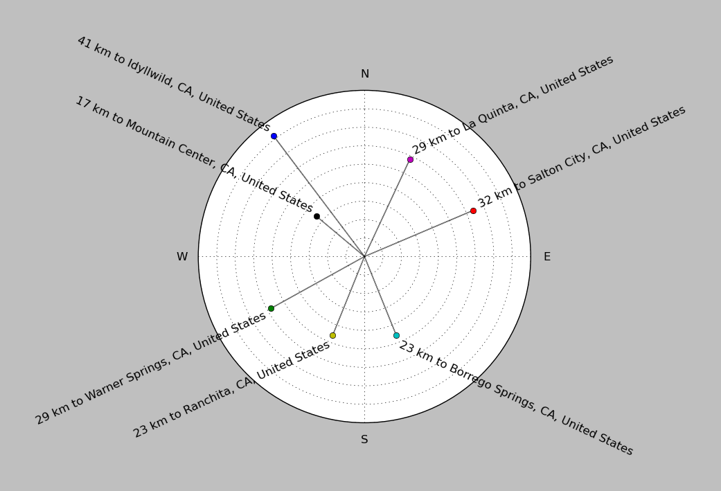
| ||||||||||||||||
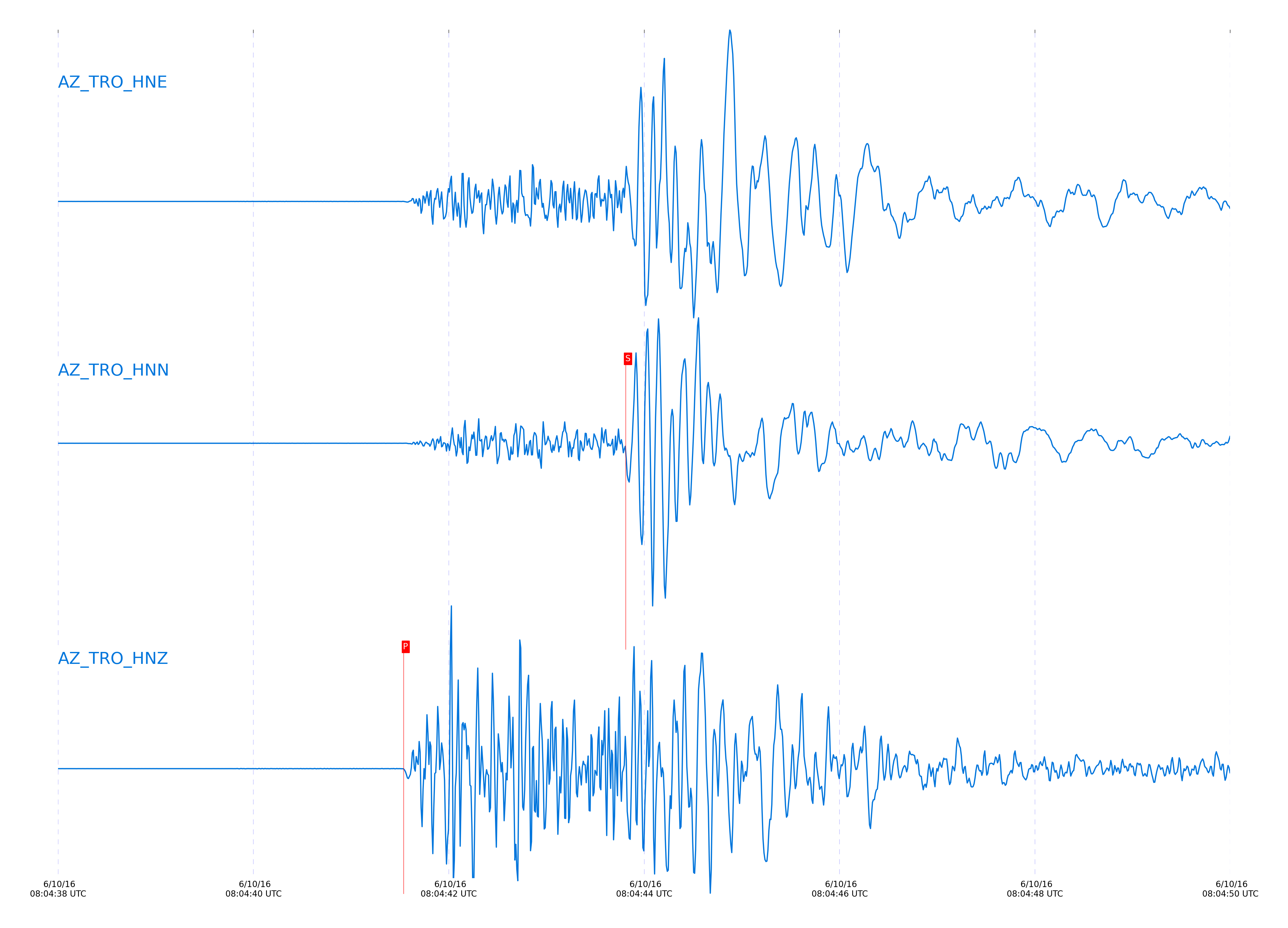
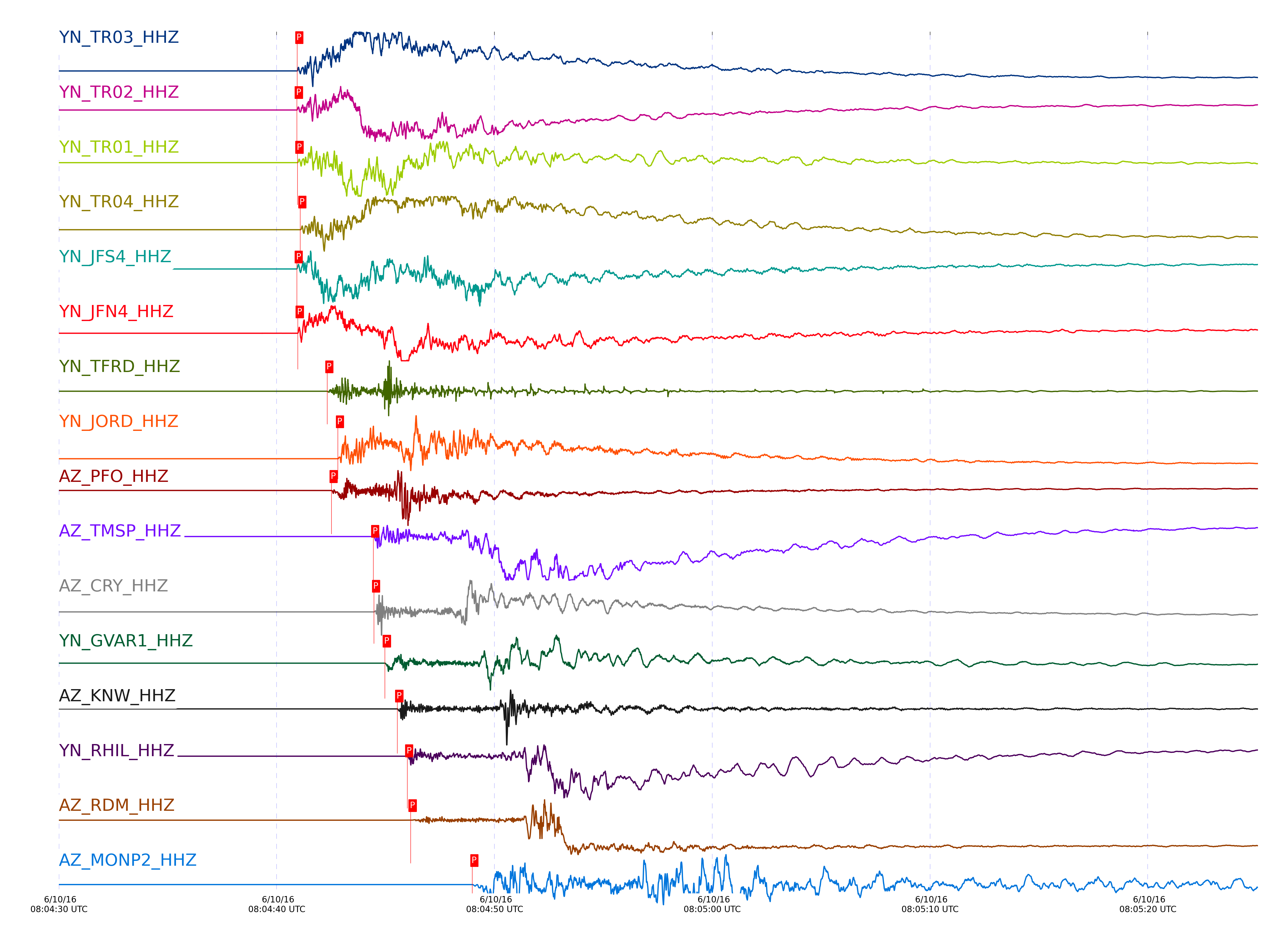
Event and active stations
|
|||||||||||||||||
Closest station with identified signal. Not filtered.
Subset of several stations close to the event. Not filtered.
| STA_CHAN | S-E Delta | S-E Azimuth | Phase | Time | Signal/Noise | Time Residual | V. Model | Auth | arid |
|---|---|---|---|---|---|---|---|---|---|
| TR02_HHZ | 0.025° | 301.42° | Pg | 2016-06-10 08:04:40.9262 UTC | -1 | 0.04 | iasp91 | dbp:jtytell:161 | 1033041 |
| TR01_HHZ | 0.026° | 289.45° | Pg | 2016-06-10 08:04:40.9552 UTC | 368850 | 0.066 | iasp91 | dbp:jtytell:161 | 1032459 |
| TR03_HHZ | 0.027° | 323.65° | Pg | 2016-06-10 08:04:40.9458 UTC | -1 | 0.05 | iasp91 | dbp:jtytell:161 | 1033042 |
| JFS4_HHZ | 0.034° | 285.83° | Pg | 2016-06-10 08:04:40.9242 UTC | -1 | -0.007 | iasp91 | dbp:jtytell:161 | 1033206 |
| TR04_HHZ | 0.036° | 336.92° | Pg | 2016-06-10 08:04:41.0882 UTC | -1 | 0.146 | iasp91 | dbp:jtytell:161 | 1033208 |
| JFN4_HHZ | 0.036° | 281.2° | Pg | 2016-06-10 08:04:40.9708 UTC | -1 | 0.028 | iasp91 | dbp:jtytell:161 | 1033207 |
| TFRD_HHZ | 0.147° | 115.4° | Pg | 2016-06-10 08:04:42.3225 UTC | -1 | 0.093 | iasp91 | dbp:jtytell:161 | 1033483 |
| TFRD_HHE | 0.147° | 115.4° | Sg | 2016-06-10 08:04:44.8847 UTC | -1 | -0.009 | iasp91 | dbp:jtytell:161 | 1034848 |
| JORD_HHZ | 0.174° | 103.5° | Pg | 2016-06-10 08:04:42.8157 UTC | 232970 | 0.17 | iasp91 | dbp:jtytell:161 | 1032468 |
| PFO_HHZ | 0.181° | 175.58° | Pg | 2016-06-10 08:04:42.5235 UTC | 132440 | -0.239 | iasp91 | dbp:jtytell:161 | 1032466 |
| PFO_HHN | 0.181° | 175.58° | sPg | 2016-06-10 08:04:45.44 UTC | -1 | 0.29 | iasp91 | dbp:jtytell:161 | 1042532 |
| TMSP_HHZ | 0.273° | 133.32° | Pg | 2016-06-10 08:04:44.4335 UTC | -1 | 0.078 | iasp91 | dbp:jtytell:161 | 1033818 |
| CRY_HHZ | 0.28° | 118.51° | Pg | 2016-06-10 08:04:44.4684 UTC | 153370 | -0.003 | iasp91 | dbp:jtytell:161 | 1032503 |
| CRY_HHN | 0.28° | 118.51° | Sg | 2016-06-10 08:04:48.3574 UTC | -1 | -0.271 | iasp91 | dbp:jtytell:161 | 1042969 |
| GVAR1_HHZ | 0.322° | 136.8° | Pg | 2016-06-10 08:04:44.9692 UTC | 162240 | -0.253 | iasp91 | dbp:jtytell:161 | 1032505 |
| GVAR1_HHN | 0.322° | 136.8° | Sg | 2016-06-10 08:04:49.3502 UTC | -1 | -0.576 | iasp91 | dbp:jtytell:161 | 1042975 |
| KNW_HHZ | 0.361° | 141.49° | Pg | 2016-06-10 08:04:45.5397 UTC | 213800 | -0.391 | iasp91 | dbp:jtytell:161 | 1032475 |
| KNW_HHN | 0.361° | 141.49° | Sg | 2016-06-10 08:04:50.3035 UTC | -1 | -0.86 | iasp91 | dbp:jtytell:161 | 1042981 |
| RHIL_HHZ | 0.365° | 131.34° | Pg | 2016-06-10 08:04:45.9948 UTC | -1 | -0.017 | iasp91 | dbp:jtytell:161 | 1033987 |
| RHIL_HHE | 0.365° | 131.34° | Sg | 2016-06-10 08:04:51.3033 UTC | -1 | -0.003 | iasp91 | dbp:jtytell:161 | 1042983 |
| RDM_HHZ | 0.392° | 120.34° | Pg | 2016-06-10 08:04:46.1524 UTC | 4907.5 | -0.344 | iasp91 | dbp:jtytell:161 | 1032486 |
| RDM_HHN | 0.392° | 120.34° | Sg | 2016-06-10 08:04:51.4391 UTC | -1 | -0.716 | iasp91 | dbp:jtytell:161 | 1043012 |
| MONP2_HHZ | 0.54° | 358.19° | Pg | 2016-06-10 08:04:48.9845 UTC | 14770 | -0.277 | iasp91 | dbp:jtytell:161 | 1032482 |
| SMER_HHZ | 0.608° | 92.27° | Pg | 2016-06-10 08:04:49.8982 UTC | 14016 | -0.652 | iasp91 | dbp:jtytell:161 | 1032483 |
| SMER_HHN | 0.608° | 92.27° | Sg | 2016-06-10 08:04:57.9699 UTC | -1 | -1.199 | iasp91 | dbp:jtytell:161 | 1043214 |
| CPE_HHZ | 0.776° | 45.44° | Pg | 2016-06-10 08:04:52.7883 UTC | 15968 | -0.935 | iasp91 | dbp:jtytell:161 | 1032485 |
| CPE_HHN | 0.776° | 45.44° | Sg | 2016-06-10 08:05:03.1242 UTC | -1 | -1.517 | iasp91 | dbp:jtytell:161 | 1043272 |
| SOL_HHZ | 0.896° | 48.57° | Pg | 2016-06-10 08:04:55.0607 UTC | 459.19 | -0.949 | iasp91 | dbp:jtytell:161 | 1032491 |
| SOL_HHN | 0.896° | 48.57° | Sg | 2016-06-10 08:05:07.2922 UTC | -1 | -1.293 | iasp91 | dbp:jtytell:161 | 1043415 |
Click the link below to observe an interactive map of earthquakes recorded by the station deployment:
Broadband Seismic Data Collection Center (ANZA),
Institute of Geophysics & Planetary Physics
Scripps Institution of Oceanography,
University of California San Diego
Copyright © 1989 - 2014. All Rights Reserved.