
last update to page: July 11 2016 17:41:06 (UTC).
SummaryThe red marker denotes the earthquake epicenter. On Mon Jul 11th 2016 02:11:04 (UTC) the seismic network recorded an earthquake (preliminary 6.3 mww) located in Near Coast Of Ecuador. Seismic region Andean South America. The epicentral distance (i.e. distance separating the location to the epicenter) to the closest station USGCB in the network is 5,250.7 km. If you felt the quake, the USGS would like to know. Please add your comments to the USGS page "Did you feel it?". |
Details
Proximity to Population Centers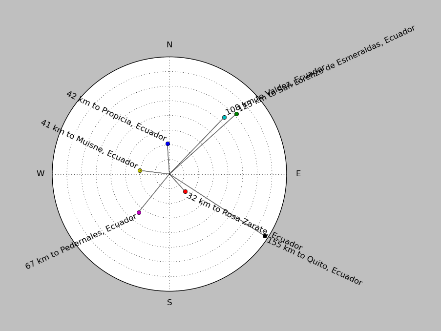
| ||||||||||||||||
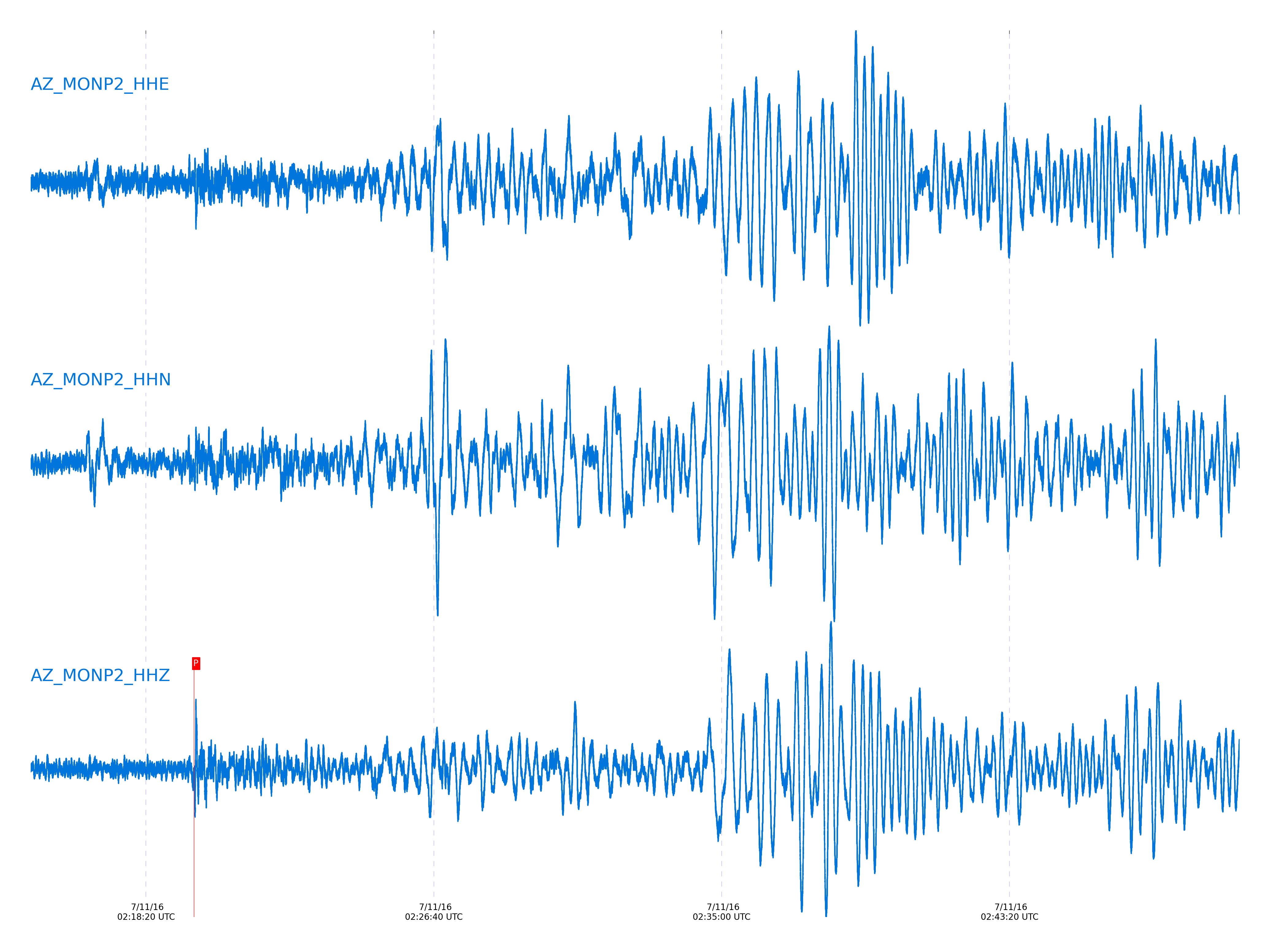
Event and active stations
|
|||||||||||||||||
Closest station with identified signal. Not filtered.
Subset of several stations close to the event. Not filtered.
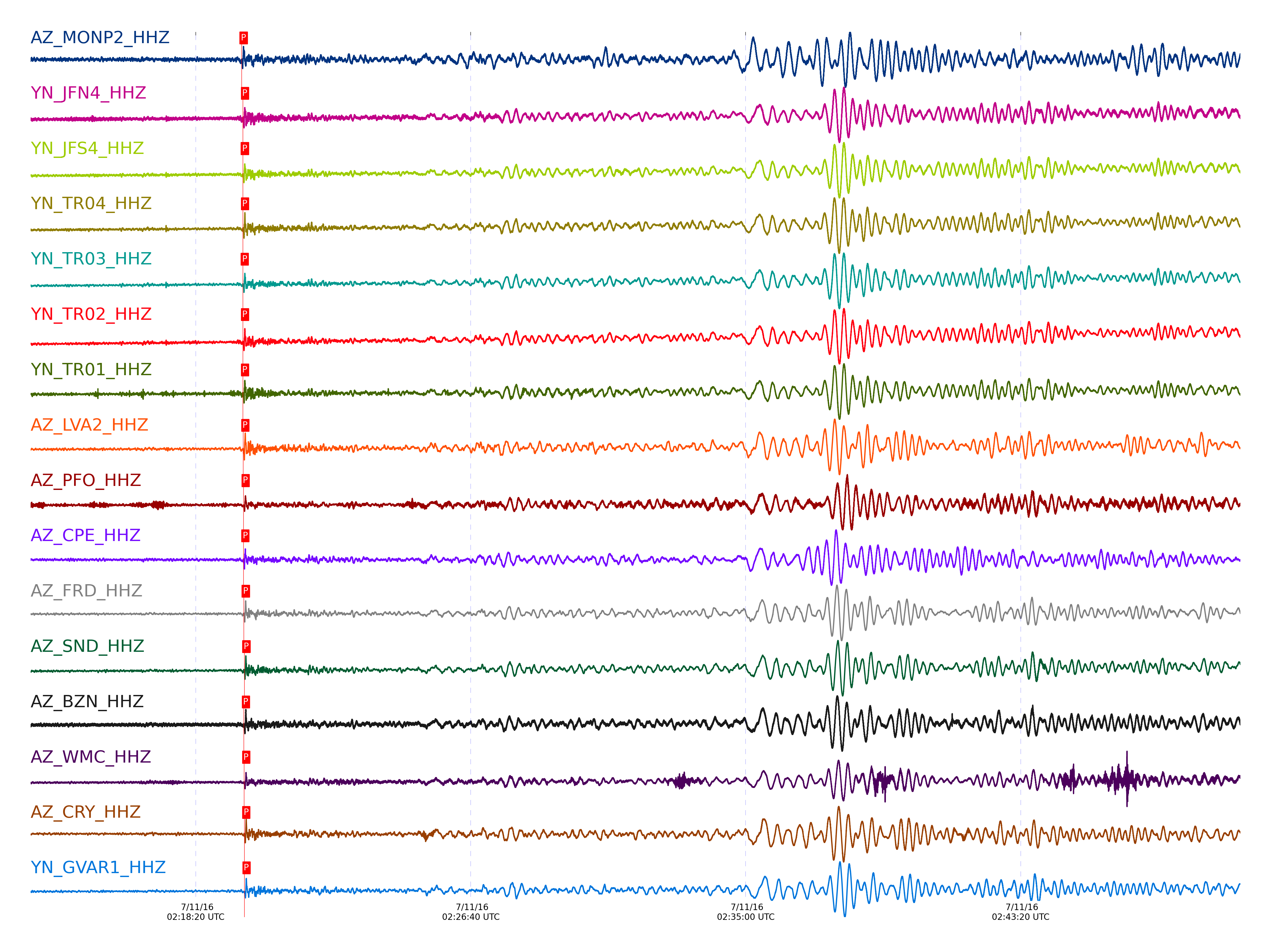
| STA_CHAN | S-E Delta | S-E Azimuth | Phase | Time | Signal/Noise | Time Residual | V. Model | Auth | arid |
|---|---|---|---|---|---|---|---|---|---|
| MONP2_HHZ | 47.317° | 125.51° | pP | 2016-07-11 02:19:43.5474 UTC | 16.058 | 0.84 | iasp91 | dbp:jtytell:161 | 1107606 |
| JFN4_HHZ | 47.613° | 125.92° | pP | 2016-07-11 02:19:45.8043 UTC | -1 | 0.788 | iasp91 | dbp:jtytell:161 | 1108005 |
| JFS4_HHZ | 47.614° | 125.92° | pP | 2016-07-11 02:19:45.7846 UTC | -1 | 0.764 | iasp91 | dbp:jtytell:161 | 1108006 |
| TR04_HHZ | 47.615° | 125.88° | pP | 2016-07-11 02:19:46.0138 UTC | -1 | 0.984 | iasp91 | dbp:jtytell:161 | 1108007 |
| TR03_HHZ | 47.619° | 125.89° | pP | 2016-07-11 02:19:45.6579 UTC | -1 | 0.593 | iasp91 | dbp:jtytell:161 | 1108008 |
| TR02_HHZ | 47.62° | 125.9° | pP | 2016-07-11 02:19:45.8591 UTC | -1 | 0.788 | iasp91 | dbp:jtytell:161 | 1108009 |
| TR01_HHZ | 47.62° | 125.91° | pP | 2016-07-11 02:19:45.9603 UTC | 26.891 | 0.886 | iasp91 | dbp:jtytell:161 | 1107573 |
| LVA2_HHZ | 47.679° | 125.71° | pP | 2016-07-11 02:19:46.5366 UTC | 36.398 | 1.007 | iasp91 | dbp:jtytell:161 | 1107569 |
| PFO_HHZ | 47.762° | 126° | pP | 2016-07-11 02:19:46.9638 UTC | 24.848 | 0.787 | iasp91 | dbp:jtytell:161 | 1107578 |
| CPE_HHZ | 47.783° | 124.83° | pP | 2016-07-11 02:19:46.7623 UTC | 24.087 | 0.42 | iasp91 | dbp:jtytell:161 | 1107576 |
| FRD_HHZ | 47.79° | 125.77° | pP | 2016-07-11 02:19:47.4237 UTC | 27.356 | 1.03 | iasp91 | dbp:jtytell:161 | 1107575 |
| JORD_HHZ | 47.806° | 125.72° | pP | 2016-07-11 02:19:44.9354 UTC | 35.077 | -1.581 | iasp91 | dbp:jtytell:161 | 1107608 |
| SND_HHZ | 47.831° | 125.81° | pP | 2016-07-11 02:19:48.5689 UTC | 24.195 | 1.86 | iasp91 | dbp:jtytell:161 | 1107587 |
| BZN_HHZ | 47.832° | 125.71° | pP | 2016-07-11 02:19:47.7006 UTC | 27.355 | 0.981 | iasp91 | dbp:jtytell:161 | 1107586 |
| WMC_HHZ | 47.885° | 125.76° | pP | 2016-07-11 02:19:48.0638 UTC | 27.83 | 0.932 | iasp91 | dbp:jtytell:161 | 1107588 |
| CRY_HHZ | 47.923° | 125.69° | pP | 2016-07-11 02:19:48.2816 UTC | 29.734 | 0.858 | iasp91 | dbp:jtytell:161 | 1107580 |
| GVAR1_HHZ | 47.961° | 125.8° | pP | 2016-07-11 02:19:48.7483 UTC | 25.193 | 1.029 | iasp91 | dbp:jtytell:161 | 1107582 |
| KNW_HHZ | 47.993° | 125.83° | pP | 2016-07-11 02:19:48.8705 UTC | 41.061 | 0.906 | iasp91 | dbp:jtytell:161 | 1107610 |
| RHIL_HHZ | 48.009° | 125.74° | pP | 2016-07-11 02:19:49.1665 UTC | -1 | 1.077 | iasp91 | dbp:jtytell:161 | 1108023 |
| BCCC_HHZ | 48.02° | 125.68° | pP | 2016-07-11 02:19:48.9611 UTC | 34.069 | 0.784 | iasp91 | dbp:jtytell:161 | 1107611 |
| RDM_HHZ | 48.035° | 125.63° | pP | 2016-07-11 02:19:49.1767 UTC | 45.413 | 0.881 | iasp91 | dbp:jtytell:161 | 1107612 |
| SMER_HHZ | 48.155° | 125.19° | pP | 2016-07-11 02:19:50.785 UTC | 18.885 | 1.563 | iasp91 | dbp:jtytell:161 | 1107592 |
Click the link below to observe an interactive map of earthquakes recorded by the station deployment:
Broadband Seismic Data Collection Center (ANZA),
Institute of Geophysics & Planetary Physics
Scripps Institution of Oceanography,
University of California San Diego
Copyright © 1989 - 2014. All Rights Reserved.