
last update to page: July 29 2016 22:40:19 (UTC).
SummaryThe red marker denotes the earthquake epicenter. On Fri Jul 29th 2016 21:18:25 (UTC) the seismic network recorded an earthquake (preliminary 7.7 mww) located in Mariana Islands. Seismic region Guam To Japan. The epicentral distance (i.e. distance separating the location to the epicenter) to the closest station CSLB in the network is 9,448.6 km. If you felt the quake, the USGS would like to know. Please add your comments to the USGS page "Did you feel it?". |
Details
Proximity to Population Centers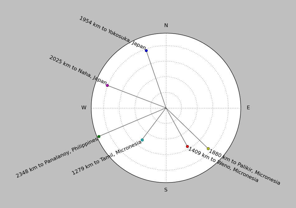
| ||||||||||||||||
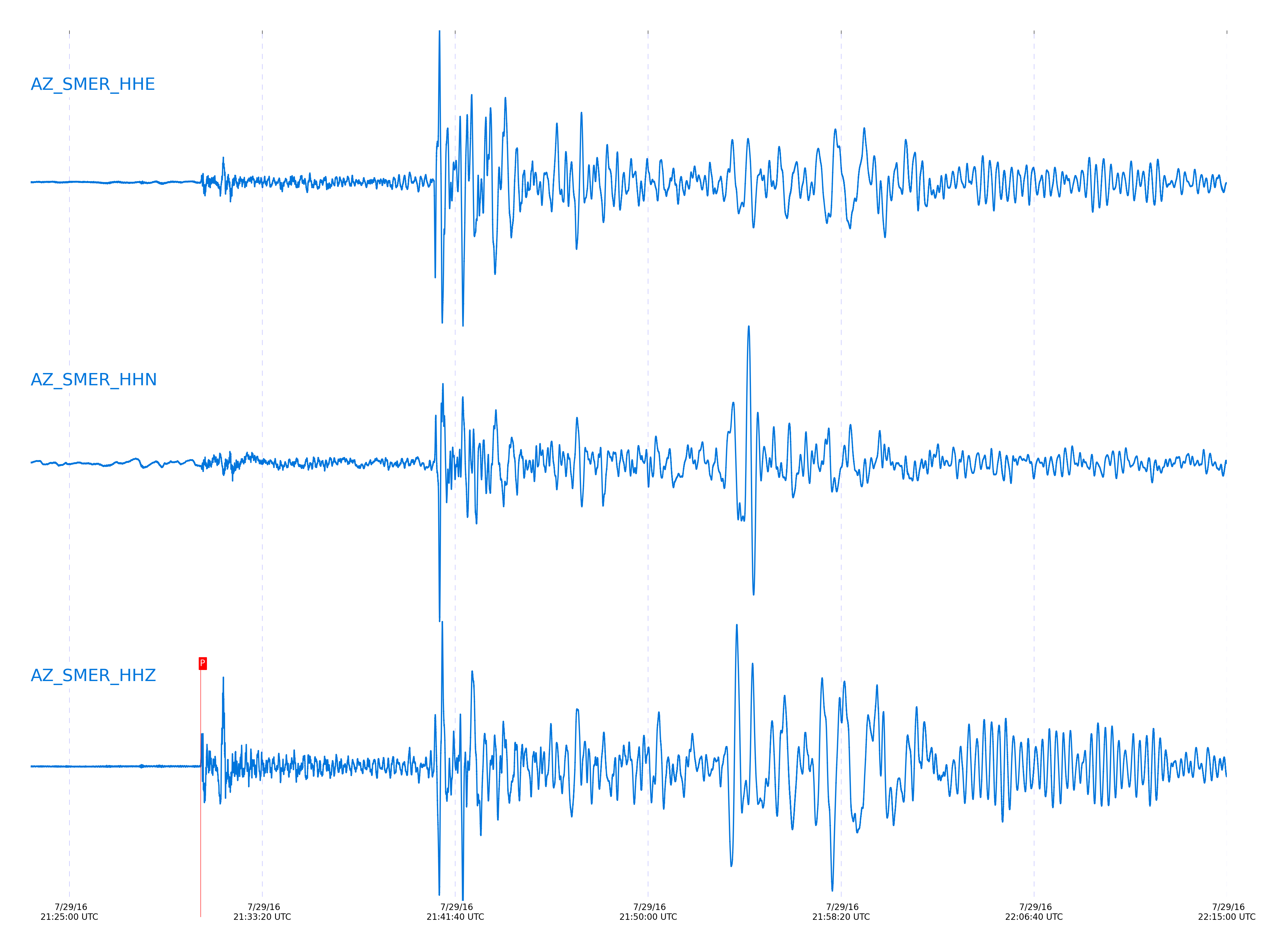
Event and active stations
|
|||||||||||||||||
Closest station with identified signal. Not filtered.
Subset of several stations close to the event. Not filtered.
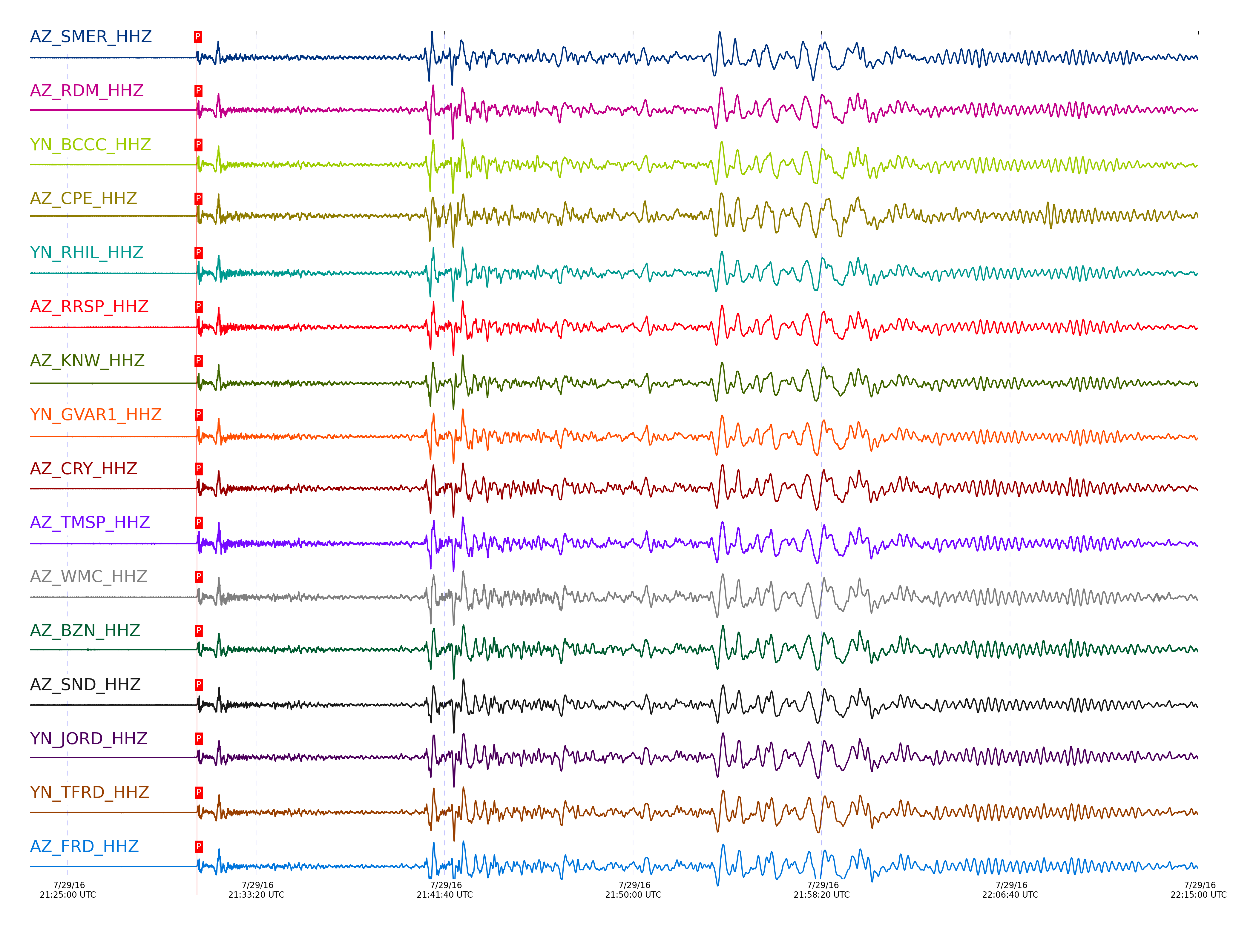
| STA_CHAN | S-E Delta | S-E Azimuth | Phase | Time | Signal/Noise | Time Residual | V. Model | Auth | arid |
|---|---|---|---|---|---|---|---|---|---|
| SMER_HHZ | 85.724° | 289.41° | P | 2016-07-29 21:30:40.3959 UTC | -1 | -0.417 | iasp91 | dbp:jtytell:162 | 1128727 |
| RDM_HHZ | 85.921° | 289.57° | P | 2016-07-29 21:30:41.8291 UTC | -1 | 0.054 | iasp91 | dbp:jtytell:162 | 1128731 |
| BCCC_HHZ | 85.944° | 289.59° | P | 2016-07-29 21:30:41.8446 UTC | -1 | -0.045 | iasp91 | dbp:jtytell:162 | 1128733 |
| CPE_HHZ | 85.966° | 289.48° | P | 2016-07-29 21:30:41.9495 UTC | -1 | -0.045 | iasp91 | dbp:jtytell:162 | 1128734 |
| RHIL_HHZ | 85.966° | 289.61° | P | 2016-07-29 21:30:42.1756 UTC | -1 | 0.178 | iasp91 | dbp:jtytell:162 | 1128735 |
| RRSP_HHZ | 85.998° | 289.62° | P | 2016-07-29 21:30:42.3087 UTC | -1 | 0.153 | iasp91 | dbp:jtytell:162 | 1128739 |
| KNW_HHZ | 85.999° | 289.63° | P | 2016-07-29 21:30:42.0881 UTC | -1 | -0.07 | iasp91 | dbp:jtytell:162 | 1128740 |
| GVAR1_HHZ | 86.019° | 289.64° | P | 2016-07-29 21:30:42.3604 UTC | -1 | 0.104 | iasp91 | dbp:jtytell:162 | 1128742 |
| CRY_HHZ | 86.029° | 289.63° | P | 2016-07-29 21:30:42.3093 UTC | -1 | 0.004 | iasp91 | dbp:jtytell:162 | 1128743 |
| TMSP_HHZ | 86.055° | 289.66° | P | 2016-07-29 21:30:42.7841 UTC | -1 | 0.352 | iasp91 | dbp:jtytell:162 | 1128746 |
| WMC_HHZ | 86.075° | 289.66° | P | 2016-07-29 21:30:42.7091 UTC | -1 | 0.178 | iasp91 | dbp:jtytell:162 | 1128748 |
| BZN_HHZ | 86.109° | 289.67° | P | 2016-07-29 21:30:42.6999 UTC | -1 | 0.004 | iasp91 | dbp:jtytell:162 | 1128750 |
| SND_HHZ | 86.131° | 289.7° | P | 2016-07-29 21:30:42.9565 UTC | -1 | 0.153 | iasp91 | dbp:jtytell:162 | 1128752 |
| JORD_HHZ | 86.133° | 289.69° | P | 2016-07-29 21:30:42.8654 UTC | -1 | 0.054 | iasp91 | dbp:jtytell:162 | 1128753 |
| TFRD_HHZ | 86.159° | 289.71° | P | 2016-07-29 21:30:42.8685 UTC | -1 | -0.07 | iasp91 | dbp:jtytell:162 | 1128793 |
| FRD_HHZ | 86.159° | 289.71° | P | 2016-07-29 21:30:42.9426 UTC | -1 | 0.004 | iasp91 | dbp:jtytell:162 | 1128757 |
| PFO_HHZ | 86.231° | 289.78° | P | 2016-07-29 21:30:43.3203 UTC | -1 | 0.029 | iasp91 | dbp:jtytell:162 | 1128763 |
| LVA2_HHZ | 86.239° | 289.74° | P | 2016-07-29 21:30:43.3333 UTC | -1 | 0.004 | iasp91 | dbp:jtytell:162 | 1128767 |
| TRO_HHZ | 86.288° | 289.8° | P | 2016-07-29 21:30:43.7429 UTC | -1 | 0.178 | iasp91 | dbp:jtytell:162 | 1128774 |
| TR03_HHZ | 86.328° | 289.81° | P | 2016-07-29 21:30:43.6419 UTC | -1 | -0.12 | iasp91 | dbp:jtytell:162 | 1128776 |
| TR04_HHZ | 86.33° | 289.81° | P | 2016-07-29 21:30:43.7732 UTC | -1 | 0.004 | iasp91 | dbp:jtytell:162 | 1128777 |
| TR02_HHZ | 86.33° | 289.81° | P | 2016-07-29 21:30:43.7018 UTC | -1 | -0.07 | iasp91 | dbp:jtytell:162 | 1128778 |
| TR01_HHZ | 86.331° | 289.81° | P | 2016-07-29 21:30:43.7316 UTC | -1 | -0.045 | iasp91 | dbp:jtytell:162 | 1128779 |
| JFS4_HHZ | 86.339° | 289.82° | P | 2016-07-29 21:30:43.7448 UTC | -1 | -0.07 | iasp91 | dbp:jtytell:162 | 1128780 |
| JFN4_HHZ | 86.341° | 289.82° | P | 2016-07-29 21:30:43.7025 UTC | -1 | -0.12 | iasp91 | dbp:jtytell:162 | 1128781 |
| MONP2_HHZ | 86.504° | 289.84° | P | 2016-07-29 21:30:44.7688 UTC | -1 | 0.153 | iasp91 | dbp:jtytell:162 | 1128786 |
Click the link below to observe an interactive map of earthquakes recorded by the station deployment:
Broadband Seismic Data Collection Center (ANZA),
Institute of Geophysics & Planetary Physics
Scripps Institution of Oceanography,
University of California San Diego
Copyright © 1989 - 2014. All Rights Reserved.