
last update to page: August 19 2016 17:58:41 (UTC).
SummaryThe red marker denotes the earthquake epicenter. On Fri Aug 19th 2016 07:32:22 (UTC) the seismic network recorded an earthquake (preliminary 7.4 mww) located in South Georgia Island Region. Seismic region Southern Antilles. The epicentral distance (i.e. distance separating the location to the epicenter) to the closest station USGCB in the network is 12,642.5 km. If you felt the quake, the USGS would like to know. Please add your comments to the USGS page "Did you feel it?". |
Details
Proximity to Population Centers
| ||||||||||||||||
Event and active stations
|
|||||||||||||||||
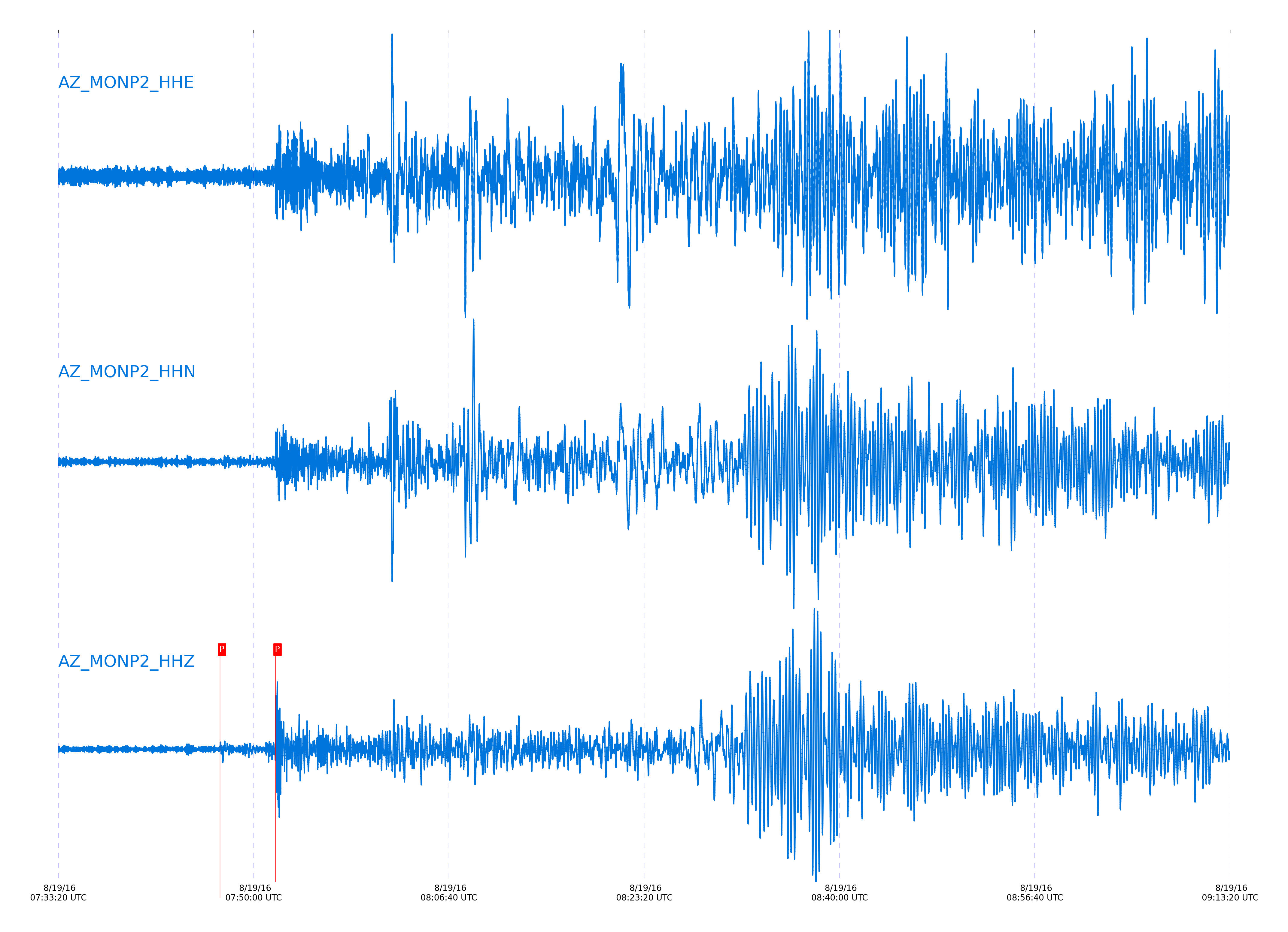
Closest station with identified signal. Not filtered.
Subset of several stations close to the event. Not filtered.
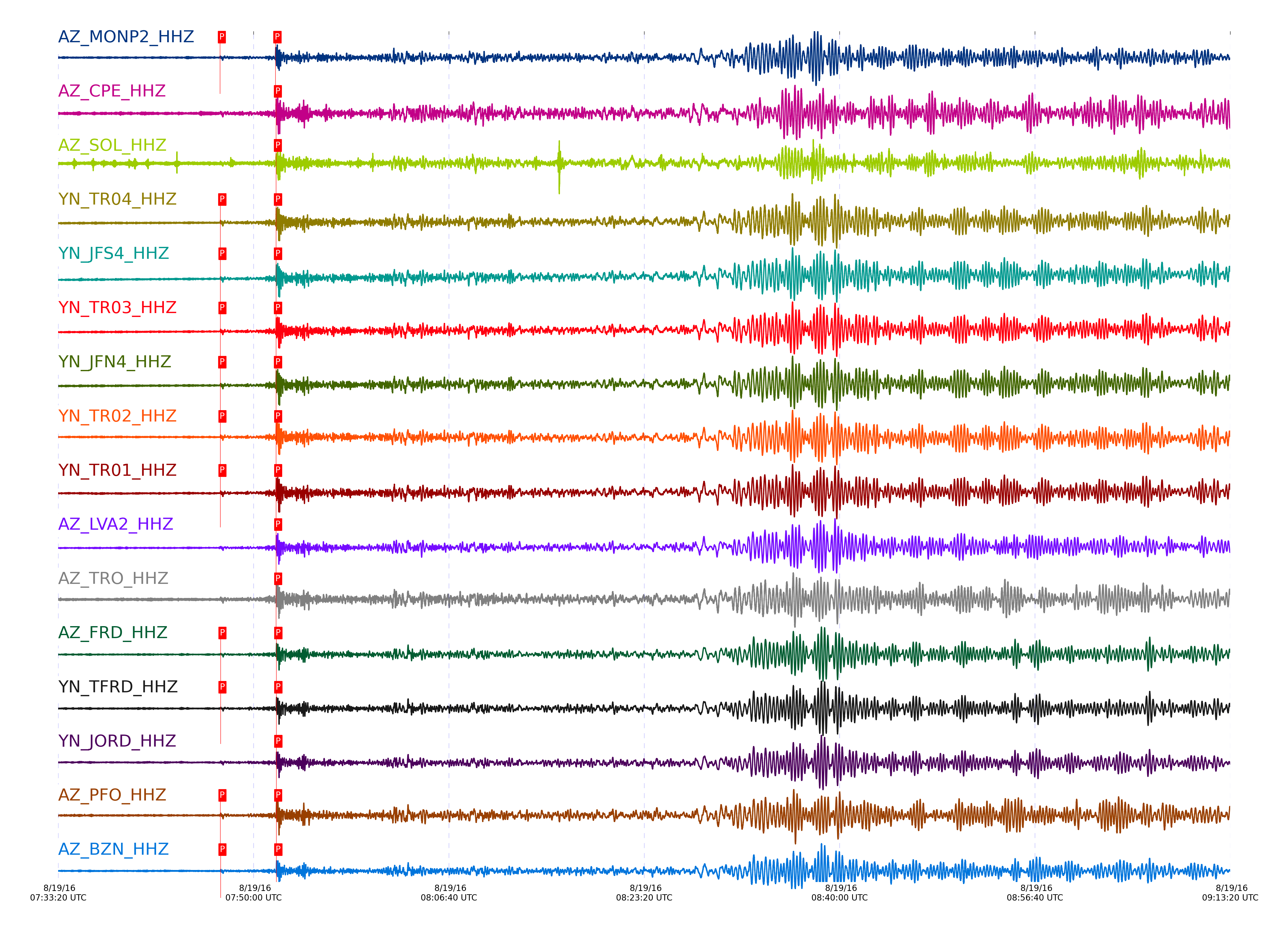
| STA_CHAN | S-E Delta | S-E Azimuth | Phase | Time | Signal/Noise | Time Residual | V. Model | Auth | arid |
|---|---|---|---|---|---|---|---|---|---|
| MONP2_HHZ | 113.636° | 141.76° | PP | 2016-08-19 07:51:52.4539 UTC | -1 | -0.75 | iasp91 | dbp:jtytell:162 | 1159966 |
| MONP2_HHZ | 113.636° | 141.76° | Pdiff | 2016-08-19 07:47:08.0763 UTC | -1 | -0.27 | iasp91 | dbp:jtytell:162 | 1159970 |
| CPE_HHZ | 113.989° | 141.59° | PP | 2016-08-19 07:51:55.0539 UTC | -1 | -0.657 | iasp91 | dbp:jtytell:162 | 1160018 |
| SOL_HHZ | 114.026° | 141.57° | PP | 2016-08-19 07:51:54.9882 UTC | -1 | -0.986 | iasp91 | dbp:jtytell:162 | 1160021 |
| TR04_HHZ | 114.035° | 141.62° | Pdiff | 2016-08-19 07:47:10.0496 UTC | -1 | -0.071 | iasp91 | dbp:jtytell:162 | 1159975 |
| TR04_HHZ | 114.035° | 141.62° | PP | 2016-08-19 07:51:55.554 UTC | -1 | -0.487 | iasp91 | dbp:jtytell:162 | 1160022 |
| JFS4_HHZ | 114.042° | 141.62° | Pdiff | 2016-08-19 07:47:10.4079 UTC | -1 | 0.257 | iasp91 | dbp:jtytell:162 | 1159976 |
| JFS4_HHZ | 114.042° | 141.62° | PP | 2016-08-19 07:51:55.5673 UTC | -1 | -0.523 | iasp91 | dbp:jtytell:162 | 1160023 |
| TR03_HHZ | 114.042° | 141.62° | Pdiff | 2016-08-19 07:47:10.408 UTC | -1 | 0.256 | iasp91 | dbp:jtytell:162 | 1159977 |
| TR03_HHZ | 114.042° | 141.62° | PP | 2016-08-19 07:51:55.431 UTC | -1 | -0.659 | iasp91 | dbp:jtytell:162 | 1160024 |
| JFN4_HHZ | 114.043° | 141.62° | Pdiff | 2016-08-19 07:47:10.236 UTC | -1 | 0.084 | iasp91 | dbp:jtytell:162 | 1159978 |
| JFN4_HHZ | 114.043° | 141.62° | PP | 2016-08-19 07:51:55.5679 UTC | -1 | -0.524 | iasp91 | dbp:jtytell:162 | 1160025 |
| TR02_HHZ | 114.046° | 141.62° | Pdiff | 2016-08-19 07:47:10.4148 UTC | -1 | 0.248 | iasp91 | dbp:jtytell:162 | 1159979 |
| TR02_HHZ | 114.046° | 141.62° | PP | 2016-08-19 07:51:55.8469 UTC | -1 | -0.269 | iasp91 | dbp:jtytell:162 | 1160026 |
| TR01_HHZ | 114.048° | 141.62° | Pdiff | 2016-08-19 07:47:10.5908 UTC | -1 | 0.415 | iasp91 | dbp:jtytell:162 | 1159980 |
| TR01_HHZ | 114.048° | 141.62° | PP | 2016-08-19 07:51:55.7141 UTC | -1 | -0.415 | iasp91 | dbp:jtytell:162 | 1160027 |
| LVA2_HHZ | 114.069° | 141.6° | PP | 2016-08-19 07:51:56.0264 UTC | -1 | -0.25 | iasp91 | dbp:jtytell:162 | 1160028 |
| TRO_HHZ | 114.133° | 141.59° | PP | 2016-08-19 07:51:56.1499 UTC | -1 | -0.582 | iasp91 | dbp:jtytell:162 | 1160030 |
| FRD_HHZ | 114.202° | 141.55° | Pdiff | 2016-08-19 07:47:11.2306 UTC | -1 | 0.371 | iasp91 | dbp:jtytell:162 | 1159987 |
| FRD_HHZ | 114.202° | 141.55° | PP | 2016-08-19 07:51:56.8271 UTC | -1 | -0.394 | iasp91 | dbp:jtytell:162 | 1160032 |
| TFRD_HHZ | 114.202° | 141.55° | Pdiff | 2016-08-19 07:47:11.4032 UTC | -1 | 0.543 | iasp91 | dbp:jtytell:162 | 1159986 |
| TFRD_HHZ | 114.202° | 141.55° | PP | 2016-08-19 07:51:56.9635 UTC | -1 | -0.258 | iasp91 | dbp:jtytell:162 | 1160033 |
| JORD_HHZ | 114.206° | 141.55° | PP | 2016-08-19 07:51:56.8357 UTC | -1 | -0.418 | iasp91 | dbp:jtytell:162 | 1160035 |
| PFO_HHZ | 114.219° | 141.56° | Pdiff | 2016-08-19 07:47:10.9199 UTC | -1 | -0.018 | iasp91 | dbp:jtytell:162 | 1159989 |
| PFO_HHZ | 114.219° | 141.56° | PP | 2016-08-19 07:51:56.4522 UTC | -1 | -0.894 | iasp91 | dbp:jtytell:162 | 1160040 |
| BZN_HHZ | 114.233° | 141.53° | Pdiff | 2016-08-19 07:47:11.1176 UTC | -1 | 0.12 | iasp91 | dbp:jtytell:162 | 1159992 |
| BZN_HHZ | 114.233° | 141.53° | PP | 2016-08-19 07:51:57.1592 UTC | -1 | -0.283 | iasp91 | dbp:jtytell:162 | 1160043 |
| SND_HHZ | 114.252° | 141.53° | Pdiff | 2016-08-19 07:47:11.672 UTC | -1 | 0.589 | iasp91 | dbp:jtytell:162 | 1159993 |
| SND_HHZ | 114.252° | 141.53° | PP | 2016-08-19 07:51:57.0598 UTC | -1 | -0.518 | iasp91 | dbp:jtytell:162 | 1160044 |
| WMC_HHZ | 114.301° | 141.51° | Pdiff | 2016-08-19 07:47:10.7311 UTC | -1 | -0.569 | iasp91 | dbp:jtytell:162 | 1159995 |
| WMC_HHZ | 114.301° | 141.51° | PP | 2016-08-19 07:51:57.6991 UTC | -1 | -0.226 | iasp91 | dbp:jtytell:162 | 1160047 |
| CRY_HHZ | 114.327° | 141.5° | Pdiff | 2016-08-19 07:47:11.1258 UTC | -1 | -0.29 | iasp91 | dbp:jtytell:162 | 1159940 |
| CRY_HHZ | 114.327° | 141.5° | PP | 2016-08-19 07:51:58.0216 UTC | -1 | -0.088 | iasp91 | dbp:jtytell:162 | 1160048 |
| TMSP_HHZ | 114.34° | 141.5° | PP | 2016-08-19 07:51:58.0464 UTC | -1 | -0.155 | iasp91 | dbp:jtytell:162 | 1160049 |
| GVAR1_HHZ | 114.39° | 141.48° | Pdiff | 2016-08-19 07:47:11.9366 UTC | -1 | 0.241 | iasp91 | dbp:jtytell:162 | 1159996 |
| GVAR1_HHZ | 114.39° | 141.48° | PP | 2016-08-19 07:51:58.2789 UTC | -1 | -0.277 | iasp91 | dbp:jtytell:162 | 1160050 |
| RRSP_HHZ | 114.396° | 141.47° | Pdiff | 2016-08-19 07:47:11.4295 UTC | -1 | -0.291 | iasp91 | dbp:jtytell:162 | 1159997 |
| RRSP_HHZ | 114.396° | 141.47° | PP | 2016-08-19 07:51:58.4255 UTC | -1 | -0.169 | iasp91 | dbp:jtytell:162 | 1160051 |
| RHIL_HHZ | 114.429° | 141.46° | Pdiff | 2016-08-19 07:47:11.8386 UTC | -1 | -0.03 | iasp91 | dbp:jtytell:162 | 1159998 |
| RHIL_HHZ | 114.429° | 141.46° | PP | 2016-08-19 07:51:58.7624 UTC | -1 | -0.07 | iasp91 | dbp:jtytell:162 | 1160052 |
| KNW_HHZ | 114.43° | 141.46° | Pdiff | 2016-08-19 07:47:11.8411 UTC | -1 | -0.033 | iasp91 | dbp:jtytell:162 | 1159999 |
| KNW_HHZ | 114.43° | 141.46° | PP | 2016-08-19 07:51:58.2194 UTC | -1 | -0.621 | iasp91 | dbp:jtytell:162 | 1160053 |
| RDM_HHZ | 114.435° | 141.45° | Pdiff | 2016-08-19 07:47:11.1598 UTC | -1 | -0.735 | iasp91 | dbp:jtytell:162 | 1160000 |
| RDM_HHZ | 114.435° | 141.45° | PP | 2016-08-19 07:51:58.637 UTC | -1 | -0.237 | iasp91 | dbp:jtytell:162 | 1160055 |
| SMER_HHZ | 114.468° | 141.42° | Pdiff | 2016-08-19 07:47:11.3949 UTC | -1 | -0.647 | iasp91 | dbp:jtytell:162 | 1160002 |
| SMER_HHZ | 114.468° | 141.42° | PP | 2016-08-19 07:51:58.2906 UTC | -1 | -0.817 | iasp91 | dbp:jtytell:162 | 1160057 |
Click the link below to observe an interactive map of earthquakes recorded by the station deployment:
Broadband Seismic Data Collection Center (ANZA),
Institute of Geophysics & Planetary Physics
Scripps Institution of Oceanography,
University of California San Diego
Copyright © 1989 - 2014. All Rights Reserved.