
last update to page: September 27 2016 07:21:22 (UTC).
SummaryThe red marker denotes the earthquake epicenter. On Tue Sep 27th 2016 03:23:58 (UTC) the seismic network recorded an earthquake (preliminary 4.33 mw) located in Southern California. Seismic region California - Nevada Region. The epicentral distance (i.e. distance separating the location to the epicenter) to the closest station TONN in the network is 41.7 km. If you felt the quake, the USGS would like to know. Please add your comments to the USGS page "Did you feel it?". |
Details
Proximity to Population Centers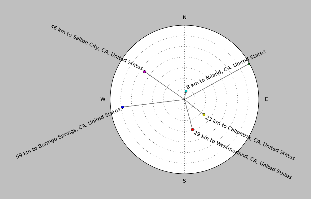
| ||||||||||||||||
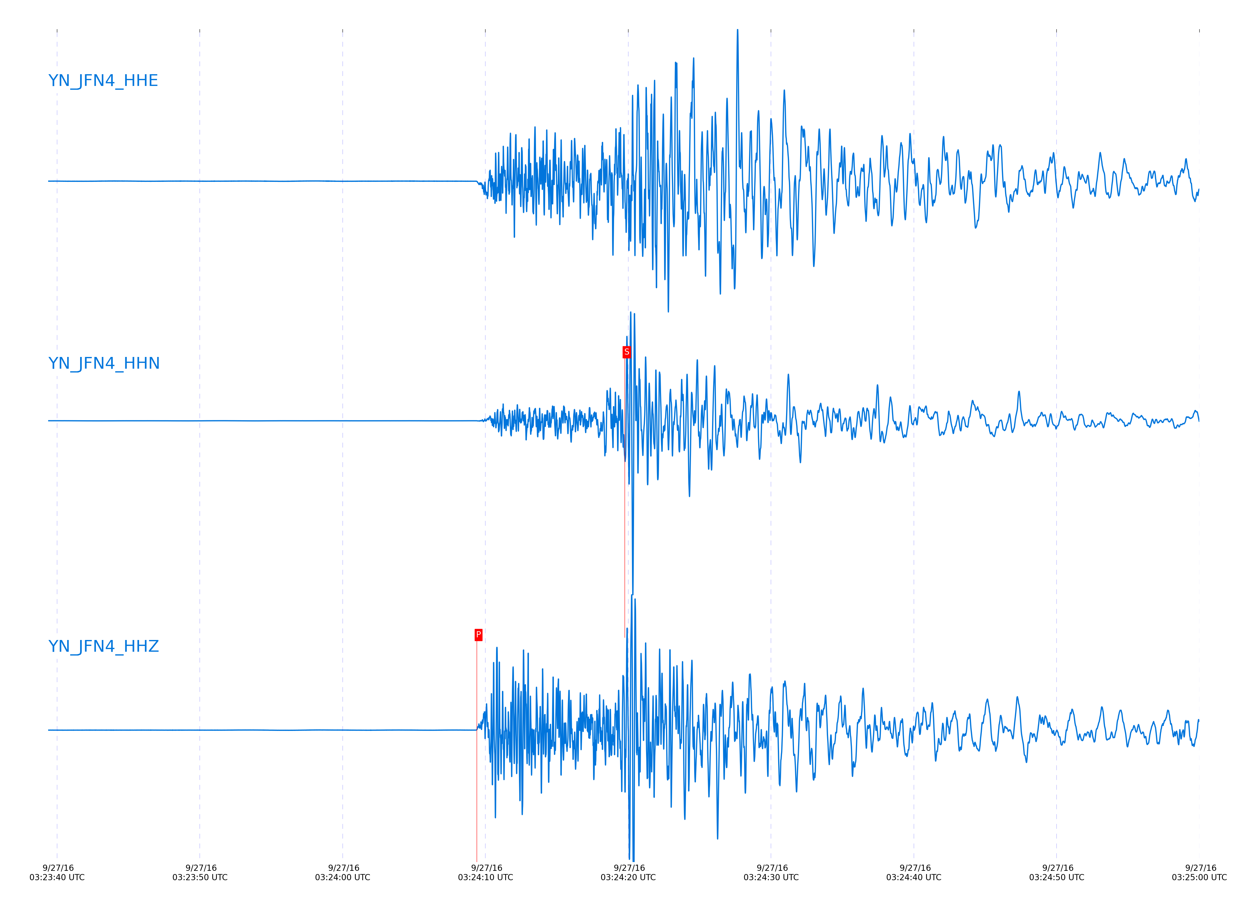
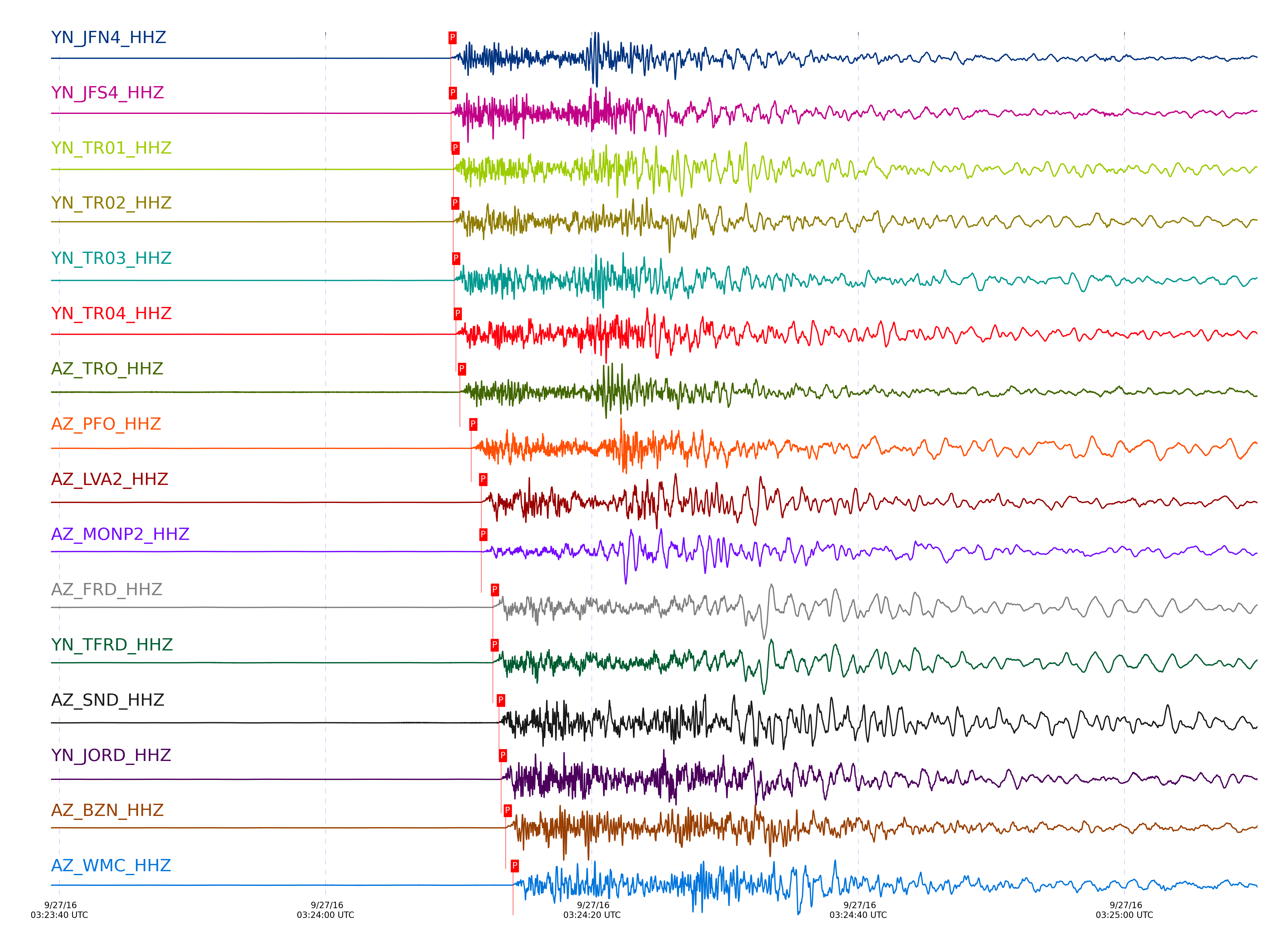
Event and active stations
|
|||||||||||||||||
Closest station with identified signal. Not filtered.
Subset of several stations close to the event. Not filtered.
| STA_CHAN | S-E Delta | S-E Azimuth | Phase | Time | Signal/Noise | Time Residual | V. Model | Auth | arid |
|---|---|---|---|---|---|---|---|---|---|
| JFN4_HHZ | 0.589° | 102.05° | Pg | 2016-09-27 03:24:09.3916 UTC | -1 | -0.067 | iasp91 | dbp:jtytell:162 | 1208324 |
| JFN4_HHN | 0.589° | 102.05° | Sg | 2016-09-27 03:24:19.7611 UTC | -1 | 2.089 | iasp91 | dbp:jtytell:162 | 1208479 |
| JFS4_HHZ | 0.59° | 101.78° | Pg | 2016-09-27 03:24:09.4128 UTC | -1 | -0.083 | iasp91 | dbp:jtytell:162 | 1208356 |
| JFS4_HHN | 0.59° | 101.78° | Sg | 2016-09-27 03:24:19.7973 UTC | -1 | 2.063 | iasp91 | dbp:jtytell:162 | 1208481 |
| TR01_HHZ | 0.598° | 101.68° | Pg | 2016-09-27 03:24:09.6145 UTC | 2841 | -0.035 | iasp91 | dbp:jtytell:162 | 1205117 |
| TR02_HHZ | 0.6° | 101.19° | Pg | 2016-09-27 03:24:09.5933 UTC | -1 | -0.09 | iasp91 | dbp:jtytell:162 | 1208357 |
| TR02_HHN | 0.6° | 101.19° | Sg | 2016-09-27 03:24:18.5337 UTC | -1 | 0.475 | iasp91 | dbp:jtytell:162 | 1208482 |
| TR03_HHZ | 0.604° | 100.27° | Pg | 2016-09-27 03:24:09.6564 UTC | -1 | -0.098 | iasp91 | dbp:jtytell:162 | 1208358 |
| TR04_HHZ | 0.604° | 99.23° | Pg | 2016-09-27 03:24:09.7806 UTC | -1 | 0.019 | iasp91 | dbp:jtytell:162 | 1208361 |
| TRO_HHZ | 0.636° | 110.38° | Pg | 2016-09-27 03:24:10.0947 UTC | 51.313 | -0.274 | iasp91 | dbp:jtytell:162 | 1205118 |
| TRO_HHE | 0.636° | 110.38° | Sb | 2016-09-27 03:24:20.9416 UTC | 381.85 | -0.684 | iasp91 | dbp:jtytell:162 | 1205223 |
| PFO_HHZ | 0.697° | 116.38° | Pg | 2016-09-27 03:24:10.9476 UTC | 629.25 | -0.586 | iasp91 | dbp:jtytell:162 | 1205121 |
| PFO_HHE | 0.697° | 116.38° | Sg | 2016-09-27 03:24:21.2672 UTC | 4077.3 | 0.015 | iasp91 | dbp:jtytell:162 | 1205222 |
| LVA2_HHZ | 0.711° | 93.94° | Pg | 2016-09-27 03:24:11.6931 UTC | 2992.2 | -0.117 | iasp91 | dbp:jtytell:162 | 1205122 |
| LVA2_HHN | 0.711° | 93.94° | Sg | 2016-09-27 03:24:22.0927 UTC | 24457 | 0.363 | iasp91 | dbp:jtytell:162 | 1205218 |
| MONP2_HHZ | 0.721° | 55.37° | Pg | 2016-09-27 03:24:11.7031 UTC | 129.44 | -0.293 | iasp91 | dbp:jtytell:162 | 1205123 |
| MONP2_HHE | 0.721° | 55.37° | Sg | 2016-09-27 03:24:21.3809 UTC | -1 | -0.67 | iasp91 | dbp:jtytell:162 | 1208519 |
| FRD_HHZ | 0.768° | 104.45° | Pg | 2016-09-27 03:24:12.5684 UTC | 807.79 | -0.325 | iasp91 | dbp:jtytell:162 | 1205124 |
| TFRD_HHZ | 0.768° | 104.46° | Pg | 2016-09-27 03:24:12.5561 UTC | -1 | -0.338 | iasp91 | dbp:jtytell:162 | 1208371 |
| SND_HHZ | 0.793° | 108.29° | Pg | 2016-09-27 03:24:13.0207 UTC | 62.587 | -0.345 | iasp91 | dbp:jtytell:162 | 1205135 |
| SND_HHN | 0.793° | 108.29° | Sg | 2016-09-27 03:24:24.8802 UTC | -1 | 0.464 | iasp91 | dbp:jtytell:162 | 1208522 |
| JORD_HHZ | 0.798° | 102.23° | Pg | 2016-09-27 03:24:13.1795 UTC | 1533.4 | -0.279 | iasp91 | dbp:jtytell:162 | 1205136 |
| JORD_HHN | 0.798° | 102.23° | Sg | 2016-09-27 03:24:24.7395 UTC | 4227.4 | 0.163 | iasp91 | dbp:jtytell:162 | 1205227 |
| BZN_HHZ | 0.82° | 103.26° | Pg | 2016-09-27 03:24:13.5337 UTC | 368.98 | -0.349 | iasp91 | dbp:jtytell:162 | 1205137 |
| WMC_HHZ | 0.849° | 108.56° | Pg | 2016-09-27 03:24:14.0719 UTC | 140.05 | -0.36 | iasp91 | dbp:jtytell:162 | 1205138 |
| TMSP_HHZ | 0.869° | 111.3° | Pg | 2016-09-27 03:24:14.3723 UTC | -1 | -0.451 | iasp91 | dbp:jtytell:162 | 1208455 |
| TMSP_HHE | 0.869° | 111.3° | Sg | 2016-09-27 03:24:27.6556 UTC | -1 | 0.725 | iasp91 | dbp:jtytell:162 | 1208526 |
| CRY_HHZ | 0.896° | 106.97° | Pg | 2016-09-27 03:24:14.5354 UTC | 547.64 | -0.8 | iasp91 | dbp:jtytell:162 | 1205146 |
| CRY_HHE | 0.896° | 106.97° | Sg | 2016-09-27 03:24:27.701 UTC | 2119.7 | -0.114 | iasp91 | dbp:jtytell:162 | 1205231 |
| GVAR1_HHZ | 0.907° | 113.57° | Pg | 2016-09-27 03:24:14.7145 UTC | 1067.7 | -0.831 | iasp91 | dbp:jtytell:162 | 1205147 |
| GVAR1_HHE | 0.907° | 113.57° | Sg | 2016-09-27 03:24:28.0349 UTC | -1 | -0.143 | iasp91 | dbp:jtytell:162 | 1208527 |
| RRSP_HHZ | 0.926° | 112.04° | Pg | 2016-09-27 03:24:15.129 UTC | -1 | -0.789 | iasp91 | dbp:jtytell:162 | 1208459 |
| KNW_HHZ | 0.931° | 116.15° | Pg | 2016-09-27 03:24:15.0384 UTC | 1271.8 | -0.968 | iasp91 | dbp:jtytell:162 | 1205149 |
| KNW_HHN | 0.931° | 116.15° | Sg | 2016-09-27 03:24:28.1254 UTC | 4061.3 | -0.849 | iasp91 | dbp:jtytell:162 | 1205248 |
| RHIL_HHZ | 0.959° | 112.62° | Pg | 2016-09-27 03:24:15.6293 UTC | -1 | -0.916 | iasp91 | dbp:jtytell:162 | 1208458 |
| BCCC_HHZ | 0.98° | 110.45° | Pg | 2016-09-27 03:24:15.822 UTC | 1003.2 | -1.123 | iasp91 | dbp:jtytell:162 | 1205178 |
| BCCC_HHN | 0.98° | 110.45° | Sg | 2016-09-27 03:24:29.9699 UTC | -1 | -0.623 | iasp91 | dbp:jtytell:162 | 1208531 |
| RDM_HHZ | 1.003° | 108.9° | Pg | 2016-09-27 03:24:16.2661 UTC | 774.91 | -1.126 | iasp91 | dbp:jtytell:162 | 1205171 |
| RDM_HHN | 1.003° | 108.9° | Sg | 2016-09-27 03:24:30.4727 UTC | -1 | -0.894 | iasp91 | dbp:jtytell:162 | 1208532 |
| SMER_HHZ | 1.228° | 96.99° | Pg | 2016-09-27 03:24:19.3584 UTC | 129.22 | -2.342 | iasp91 | dbp:jtytell:162 | 1205158 |
| CPE_HHZ | 1.237° | 70.22° | Pg | 2016-09-27 03:24:19.481 UTC | 199.24 | -2.391 | iasp91 | dbp:jtytell:162 | 1205162 |
| CPE_HHN | 1.237° | 70.22° | Sg | 2016-09-27 03:24:36.6388 UTC | -1 | -2.46 | iasp91 | dbp:jtytell:162 | 1208538 |
| SOL_HHZ | 1.366° | 69.96° | Pn | 2016-09-27 03:24:22.1984 UTC | 44.774 | -1.681 | iasp91 | dbp:jtytell:162 | 1205167 |
Click the link below to observe an interactive map of earthquakes recorded by the station deployment:
Broadband Seismic Data Collection Center (ANZA),
Institute of Geophysics & Planetary Physics
Scripps Institution of Oceanography,
University of California San Diego
Copyright © 1989 - 2014. All Rights Reserved.