
last update to page: September 27 2016 07:36:03 (UTC).
SummaryThe red marker denotes the earthquake epicenter. On Tue Sep 27th 2016 03:36:15 (UTC) the seismic network recorded an earthquake (preliminary 4.13 mw) located in Southern California. Seismic region California - Nevada Region. The epicentral distance (i.e. distance separating the location to the epicenter) to the closest station TONN in the network is 42.9 km. If you felt the quake, the USGS would like to know. Please add your comments to the USGS page "Did you feel it?". |
Details
Proximity to Population Centers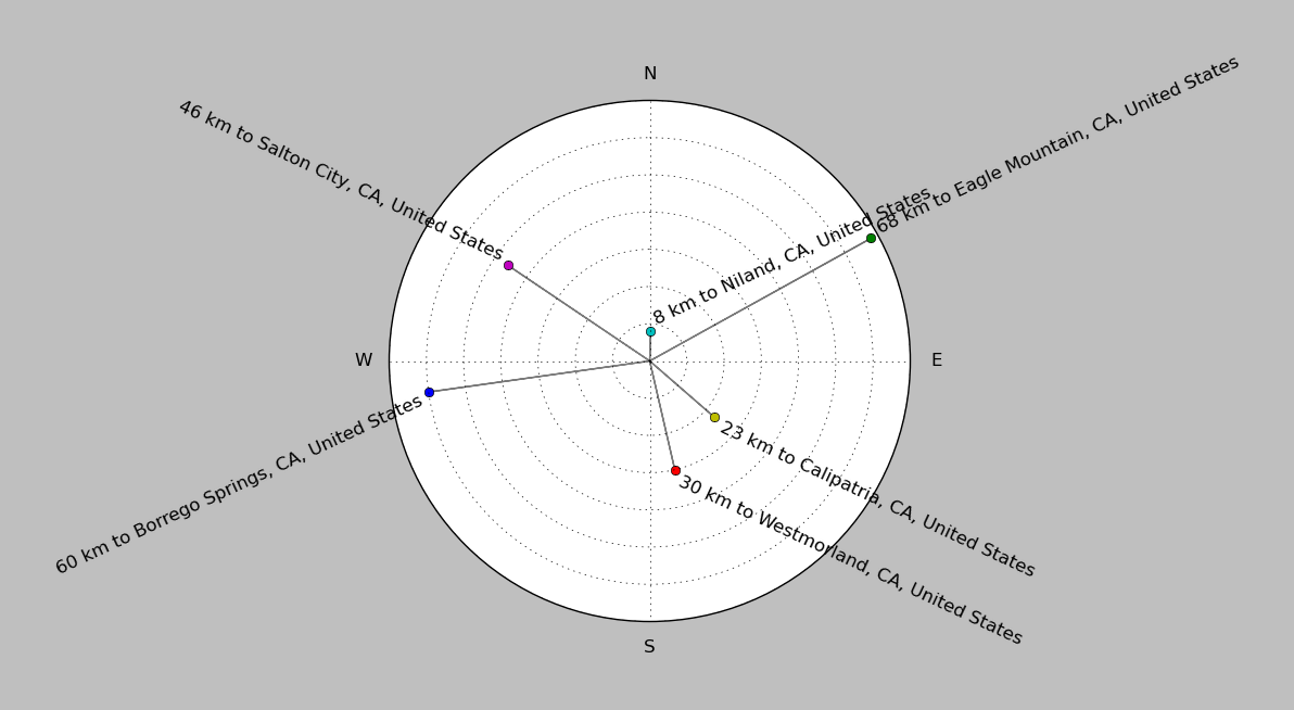
| ||||||||||||||||
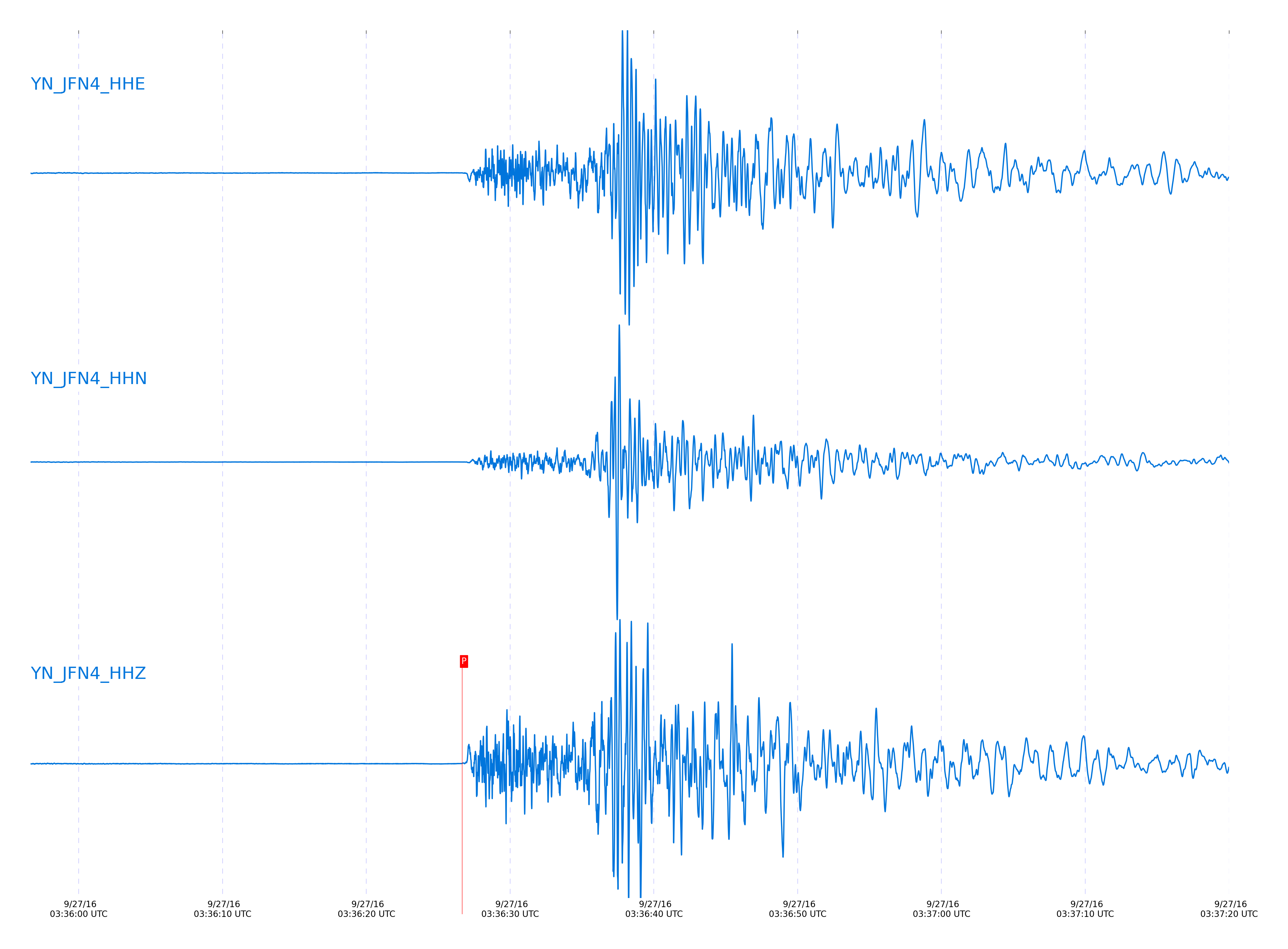
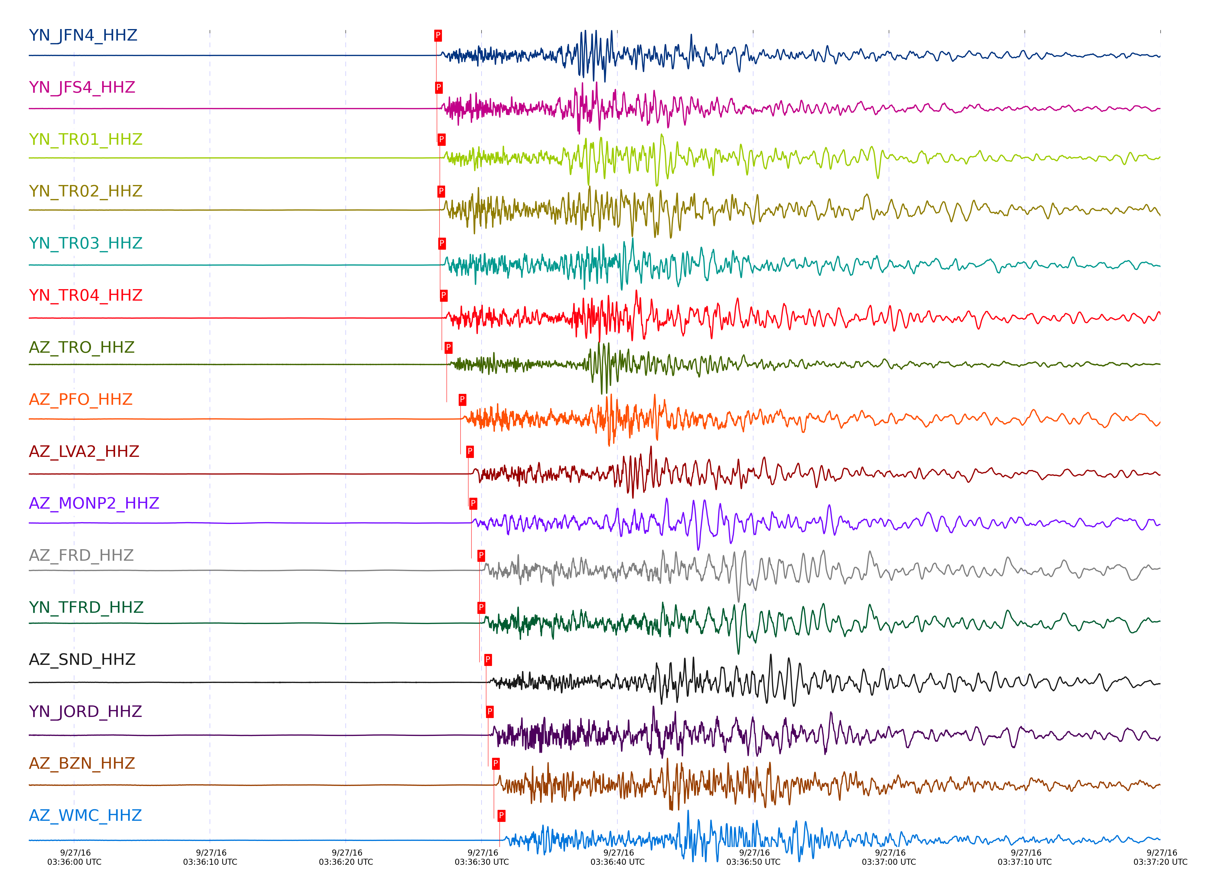
Event and active stations
|
|||||||||||||||||
Closest station with identified signal. Not filtered.
Subset of several stations close to the event. Not filtered.
| STA_CHAN | S-E Delta | S-E Azimuth | Phase | Time | Signal/Noise | Time Residual | V. Model | Auth | arid |
|---|---|---|---|---|---|---|---|---|---|
| JFN4_HHZ | 0.596° | 101.3° | Pg | 2016-09-27 03:36:26.6629 UTC | -1 | -0.017 | iasp91 | dbp:jtytell:162 | 1208806 |
| JFS4_HHZ | 0.598° | 101.03° | Pg | 2016-09-27 03:36:26.7135 UTC | -1 | -0.003 | iasp91 | dbp:jtytell:162 | 1208811 |
| JFS4_HHE | 0.598° | 101.03° | Sg | 2016-09-27 03:36:35.735 UTC | -1 | 0.681 | iasp91 | dbp:jtytell:162 | 1208861 |
| TR01_HHZ | 0.606° | 100.94° | Pg | 2016-09-27 03:36:26.92 UTC | 716.05 | 0.049 | iasp91 | dbp:jtytell:162 | 1205515 |
| TR02_HHZ | 0.608° | 100.46° | Pg | 2016-09-27 03:36:26.8949 UTC | -1 | -0.011 | iasp91 | dbp:jtytell:162 | 1208812 |
| TR03_HHZ | 0.612° | 99.55° | Pg | 2016-09-27 03:36:26.9513 UTC | -1 | -0.028 | iasp91 | dbp:jtytell:162 | 1208813 |
| TR04_HHZ | 0.613° | 98.53° | Pg | 2016-09-27 03:36:27.0745 UTC | -1 | 0.085 | iasp91 | dbp:jtytell:162 | 1208818 |
| TRO_HHZ | 0.643° | 109.58° | Pg | 2016-09-27 03:36:27.4258 UTC | 74.997 | -0.14 | iasp91 | dbp:jtytell:162 | 1205516 |
| PFO_HHZ | 0.703° | 115.59° | Pg | 2016-09-27 03:36:28.4484 UTC | 535.34 | -0.264 | iasp91 | dbp:jtytell:162 | 1205519 |
| PFO_HHN | 0.703° | 115.59° | Sg | 2016-09-27 03:36:38.0291 UTC | -1 | -0.476 | iasp91 | dbp:jtytell:162 | 1208870 |
| LVA2_HHZ | 0.72° | 93.41° | Pg | 2016-09-27 03:36:29.0081 UTC | 796.1 | -0.041 | iasp91 | dbp:jtytell:162 | 1205520 |
| LVA2_HHN | 0.72° | 93.41° | Sg | 2016-09-27 03:36:39.4449 UTC | 6797.2 | 0.356 | iasp91 | dbp:jtytell:162 | 1205617 |
| MONP2_HHZ | 0.732° | 55.4° | Pg | 2016-09-27 03:36:29.2484 UTC | 116.05 | -0.029 | iasp91 | dbp:jtytell:162 | 1205521 |
| FRD_HHZ | 0.776° | 103.85° | Pg | 2016-09-27 03:36:29.8407 UTC | 598.9 | -0.274 | iasp91 | dbp:jtytell:162 | 1205522 |
| FRD_HHE | 0.776° | 103.85° | Sg | 2016-09-27 03:36:40.9239 UTC | 2061 | 0.007 | iasp91 | dbp:jtytell:162 | 1205633 |
| TFRD_HHZ | 0.776° | 103.85° | Pg | 2016-09-27 03:36:29.8451 UTC | -1 | -0.27 | iasp91 | dbp:jtytell:162 | 1208828 |
| TFRD_HHN | 0.776° | 103.85° | Sg | 2016-09-27 03:36:40.8549 UTC | -1 | -0.063 | iasp91 | dbp:jtytell:162 | 1208877 |
| SND_HHZ | 0.8° | 107.67° | Pg | 2016-09-27 03:36:30.3352 UTC | 87.641 | -0.242 | iasp91 | dbp:jtytell:162 | 1205533 |
| SND_HHE | 0.8° | 107.67° | Sg | 2016-09-27 03:36:41.8373 UTC | 992.02 | 0.122 | iasp91 | dbp:jtytell:162 | 1205631 |
| JORD_HHZ | 0.806° | 101.66° | Pg | 2016-09-27 03:36:30.4729 UTC | 673.79 | -0.214 | iasp91 | dbp:jtytell:162 | 1205534 |
| JORD_HHN | 0.806° | 101.66° | Sg | 2016-09-27 03:36:41.8082 UTC | 1229.1 | -0.096 | iasp91 | dbp:jtytell:162 | 1205627 |
| BZN_HHZ | 0.828° | 102.7° | Pg | 2016-09-27 03:36:30.9147 UTC | 232.46 | -0.194 | iasp91 | dbp:jtytell:162 | 1205535 |
| BZN_HHN | 0.828° | 102.7° | Sg | 2016-09-27 03:36:42.5768 UTC | 677.24 | -0.056 | iasp91 | dbp:jtytell:162 | 1205635 |
| WMC_HHZ | 0.856° | 107.97° | Pg | 2016-09-27 03:36:31.3254 UTC | 393.55 | -0.319 | iasp91 | dbp:jtytell:162 | 1205546 |
| WMC_HHN | 0.856° | 107.97° | Sg | 2016-09-27 03:36:43.5632 UTC | 1650.8 | 0.007 | iasp91 | dbp:jtytell:162 | 1205637 |
| TMSP_HHZ | 0.875° | 110.7° | Pg | 2016-09-27 03:36:31.9171 UTC | -1 | -0.11 | iasp91 | dbp:jtytell:162 | 1208831 |
| TMSP_HHN | 0.875° | 110.7° | Sg | 2016-09-27 03:36:44.6865 UTC | -1 | 0.469 | iasp91 | dbp:jtytell:162 | 1208896 |
| CRY_HHZ | 0.903° | 106.42° | Pg | 2016-09-27 03:36:32.0128 UTC | 457.49 | -0.539 | iasp91 | dbp:jtytell:162 | 1205550 |
| CRY_HHE | 0.903° | 106.42° | Sg | 2016-09-27 03:36:44.7651 UTC | 905.39 | -0.359 | iasp91 | dbp:jtytell:162 | 1205641 |
| GVAR1_HHZ | 0.913° | 112.98° | Pg | 2016-09-27 03:36:31.9948 UTC | 843.33 | -0.748 | iasp91 | dbp:jtytell:162 | 1205548 |
| GVAR1_HHE | 0.913° | 112.98° | Sg | 2016-09-27 03:36:44.6456 UTC | 2733.4 | -0.808 | iasp91 | dbp:jtytell:162 | 1205645 |
| RRSP_HHZ | 0.933° | 111.47° | Pg | 2016-09-27 03:36:32.661 UTC | -1 | -0.459 | iasp91 | dbp:jtytell:162 | 1208834 |
| RRSP_HHE | 0.933° | 111.47° | Sg | 2016-09-27 03:36:45.9165 UTC | -1 | -0.188 | iasp91 | dbp:jtytell:162 | 1208917 |
| KNW_HHZ | 0.937° | 115.57° | Pg | 2016-09-27 03:36:32.352 UTC | 574.14 | -0.845 | iasp91 | dbp:jtytell:162 | 1205551 |
| KNW_HHN | 0.937° | 115.57° | Sg | 2016-09-27 03:36:44.9503 UTC | 1141 | -1.287 | iasp91 | dbp:jtytell:162 | 1205618 |
| RHIL_HHZ | 0.965° | 112.08° | Pg | 2016-09-27 03:36:33.2395 UTC | -1 | -0.507 | iasp91 | dbp:jtytell:162 | 1208837 |
| RHIL_HHE | 0.965° | 112.08° | Sg | 2016-09-27 03:36:47.1018 UTC | -1 | -0.085 | iasp91 | dbp:jtytell:162 | 1208920 |
| BCCC_HHZ | 0.986° | 109.92° | Pg | 2016-09-27 03:36:33.212 UTC | 368.88 | -0.941 | iasp91 | dbp:jtytell:162 | 1205552 |
| BCCC_HHN | 0.986° | 109.92° | Sg | 2016-09-27 03:36:46.9617 UTC | -1 | -0.926 | iasp91 | dbp:jtytell:162 | 1208922 |
| RDM_HHZ | 1.01° | 108.4° | Pg | 2016-09-27 03:36:33.5995 UTC | 47.033 | -1.006 | iasp91 | dbp:jtytell:162 | 1205553 |
| RDM_HHN | 1.01° | 108.4° | Sg | 2016-09-27 03:36:47.6504 UTC | -1 | -1.019 | iasp91 | dbp:jtytell:162 | 1208923 |
| SMER_HHZ | 1.237° | 96.65° | Pg | 2016-09-27 03:36:36.5396 UTC | 48.936 | -2.408 | iasp91 | dbp:jtytell:162 | 1205556 |
| CPE_HHZ | 1.248° | 70.1° | Pg | 2016-09-27 03:36:36.978 UTC | 104.07 | -2.186 | iasp91 | dbp:jtytell:162 | 1205558 |
| CPE_HHN | 1.248° | 70.1° | Sg | 2016-09-27 03:36:53.2356 UTC | -1 | -3.302 | iasp91 | dbp:jtytell:162 | 1208932 |
| SOL_HHZ | 1.377° | 69.85° | Pn | 2016-09-27 03:36:39.2766 UTC | -1 | -2.121 | iasp91 | dbp:jtytell:162 | 1208850 |
Click the link below to observe an interactive map of earthquakes recorded by the station deployment:
Broadband Seismic Data Collection Center (ANZA),
Institute of Geophysics & Planetary Physics
Scripps Institution of Oceanography,
University of California San Diego
Copyright © 1989 - 2014. All Rights Reserved.