
last update to page: December 08 2016 21:00:33 (UTC).
SummaryThe red marker denotes the earthquake epicenter. On Thu Dec 8th 2016 17:38:47 (UTC) the seismic network recorded an earthquake (preliminary 7.7 mwb) located in Solomon Islands. Seismic region Bismarck And Solomon Islands. The epicentral distance (i.e. distance separating the location to the epicenter) to the closest station SCI2 in the network is 9,763.0 km. If you felt the quake, the USGS would like to know. Please add your comments to the USGS page "Did you feel it?". |
Details
Proximity to Population Centers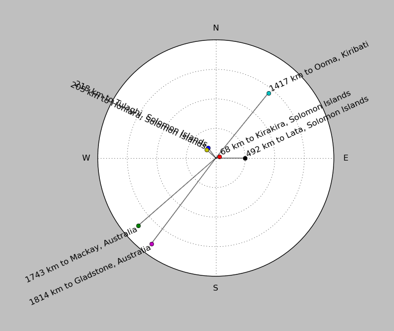
| ||||||||||||||||
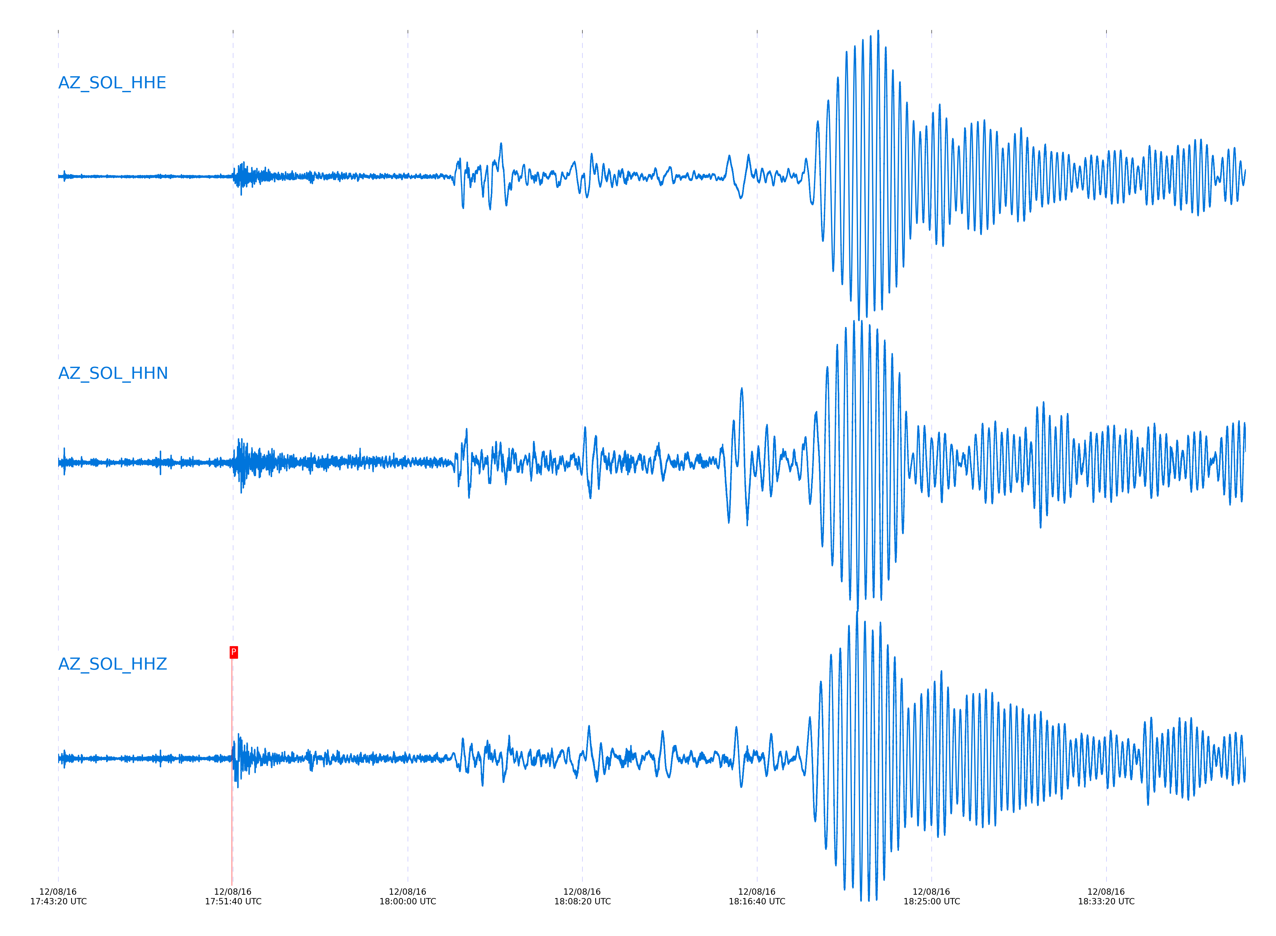
Event and active stations
|
|||||||||||||||||
Closest station with identified signal. Not filtered.
Subset of several stations close to the event. Not filtered.
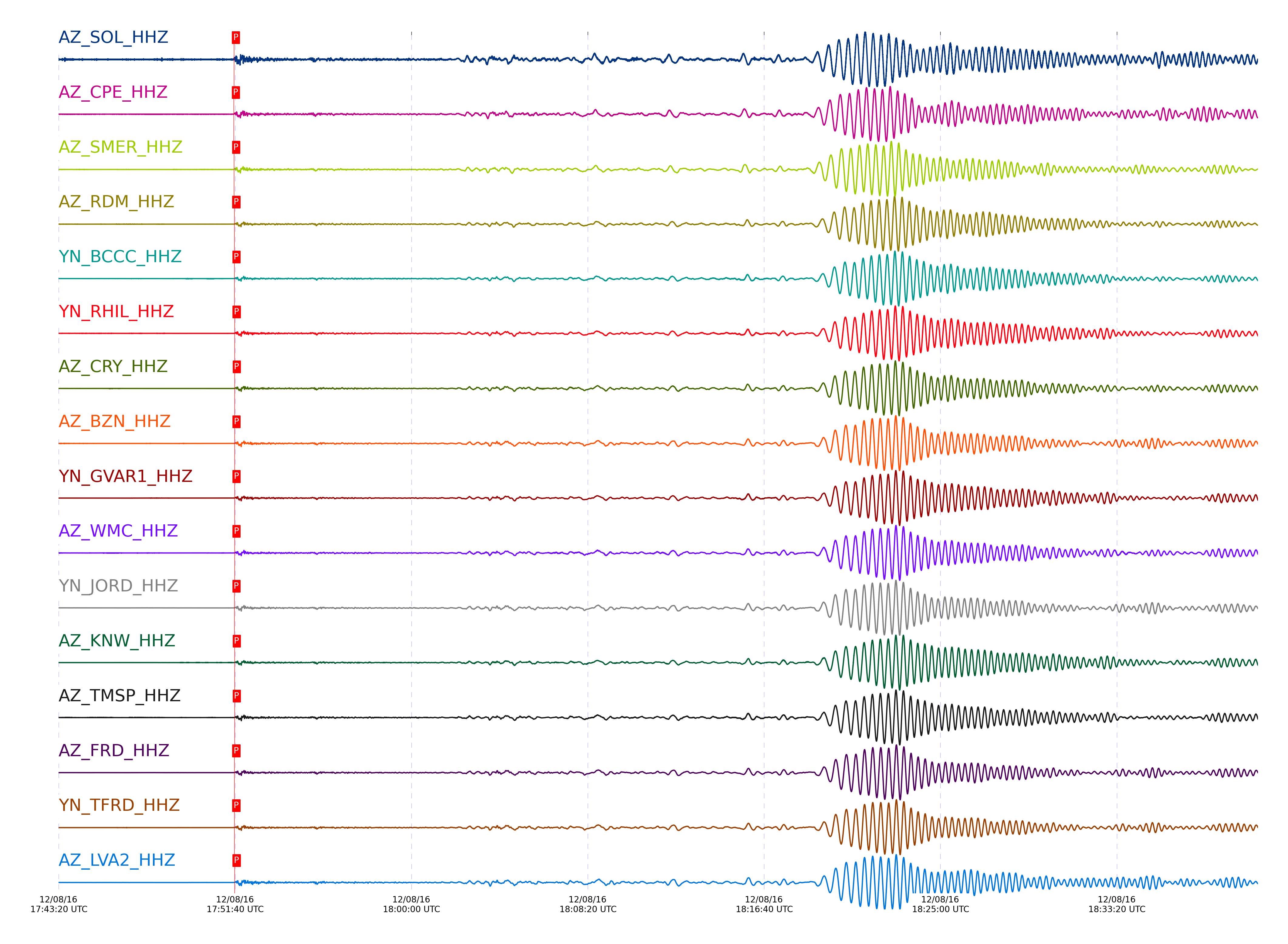
| STA_CHAN | S-E Delta | S-E Azimuth | Phase | Time | Signal/Noise | Time Residual | V. Model | Auth | arid |
|---|---|---|---|---|---|---|---|---|---|
| SOL_HHZ | 88.695° | 256.4° | PcP | 2016-12-08 17:51:36.5731 UTC | 164.7 | -0.181 | iasp91 | dbp:jtytell:163 | 1288300 |
| CPE_HHZ | 88.823° | 256.47° | P | 2016-12-08 17:51:36.379 UTC | 368.97 | 0.398 | iasp91 | dbp:jtytell:163 | 1288299 |
| SMER_HHZ | 88.903° | 256.43° | P | 2016-12-08 17:51:36.9524 UTC | 351.26 | 0.596 | iasp91 | dbp:jtytell:163 | 1288301 |
| RDM_HHZ | 89.205° | 256.6° | P | 2016-12-08 17:51:37.6722 UTC | -1 | -0.099 | iasp91 | dbp:jtytell:163 | 1288387 |
| BCCC_HHZ | 89.239° | 256.62° | P | 2016-12-08 17:51:37.8312 UTC | -1 | -0.099 | iasp91 | dbp:jtytell:163 | 1288388 |
| RHIL_HHZ | 89.277° | 256.64° | P | 2016-12-08 17:51:38.6053 UTC | -1 | 0.497 | iasp91 | dbp:jtytell:163 | 1288394 |
| CRY_HHZ | 89.279° | 256.66° | PcP | 2016-12-08 17:51:38.8166 UTC | 243.16 | -0.521 | iasp91 | dbp:jtytell:163 | 1288274 |
| BZN_HHZ | 89.319° | 256.7° | P | 2016-12-08 17:51:38.2584 UTC | 386.21 | -0.05 | iasp91 | dbp:jtytell:163 | 1288267 |
| GVAR1_HHZ | 89.327° | 256.68° | P | 2016-12-08 17:51:38.3958 UTC | 248.83 | 0.05 | iasp91 | dbp:jtytell:163 | 1288292 |
| WMC_HHZ | 89.332° | 256.7° | P | 2016-12-08 17:51:38.3673 UTC | 308.57 | -0 | iasp91 | dbp:jtytell:163 | 1288283 |
| JORD_HHZ | 89.333° | 256.72° | P | 2016-12-08 17:51:37.8243 UTC | 371.38 | -0.547 | iasp91 | dbp:jtytell:163 | 1288276 |
| KNW_HHZ | 89.334° | 256.68° | P | 2016-12-08 17:51:38.6261 UTC | -1 | 0.248 | iasp91 | dbp:jtytell:163 | 1288401 |
| TMSP_HHZ | 89.337° | 256.7° | P | 2016-12-08 17:51:38.691 UTC | -1 | 0.298 | iasp91 | dbp:jtytell:163 | 1288402 |
| FRD_HHZ | 89.373° | 256.74° | P | 2016-12-08 17:51:37.7129 UTC | 302.5 | -0.845 | iasp91 | dbp:jtytell:163 | 1288281 |
| TFRD_HHZ | 89.373° | 256.74° | P | 2016-12-08 17:51:37.564 UTC | -1 | -0.994 | iasp91 | dbp:jtytell:163 | 1288405 |
| LVA2_HHZ | 89.373° | 256.76° | P | 2016-12-08 17:51:38.4595 UTC | 350.03 | -0.099 | iasp91 | dbp:jtytell:163 | 1288298 |
| SND_HHZ | 89.377° | 256.73° | P | 2016-12-08 17:51:38.8765 UTC | 205.2 | 0.298 | iasp91 | dbp:jtytell:163 | 1288279 |
| MONP2_HHZ | 89.382° | 256.85° | P | 2016-12-08 17:51:38.6488 UTC | 502.7 | 0.05 | iasp91 | dbp:jtytell:163 | 1288272 |
| TR03_HHZ | 89.499° | 256.84° | P | 2016-12-08 17:51:39.0752 UTC | -1 | -0.071 | iasp91 | dbp:jtytell:163 | 1288413 |
| TR02_HHZ | 89.506° | 256.84° | P | 2016-12-08 17:51:39.1093 UTC | -1 | -0.071 | iasp91 | dbp:jtytell:163 | 1288414 |
| TR01_HHZ | 89.51° | 256.85° | PcP | 2016-12-08 17:51:39.8231 UTC | 303.76 | -0.532 | iasp91 | dbp:jtytell:163 | 1288288 |
| PFO_HHZ | 89.515° | 256.82° | P | 2016-12-08 17:51:38.5965 UTC | -1 | -0.628 | iasp91 | dbp:jtytell:163 | 1288418 |
| TRO_HHZ | 89.523° | 256.84° | P | 2016-12-08 17:51:39.814 UTC | 342.99 | 0.556 | iasp91 | dbp:jtytell:163 | 1288296 |
Click the link below to observe an interactive map of earthquakes recorded by the station deployment:
Broadband Seismic Data Collection Center (ANZA),
Institute of Geophysics & Planetary Physics
Scripps Institution of Oceanography,
University of California San Diego
Copyright © 1989 - 2014. All Rights Reserved.