
last update to page: December 08 2016 20:56:25 (UTC).
SummaryThe red marker denotes the earthquake epicenter. On Thu Dec 8th 2016 14:49:46 (UTC) the seismic network recorded an earthquake (preliminary 6.5 mwb) located in Off Coast Of Northern California. Seismic region California - Nevada Region. The epicentral distance (i.e. distance separating the location to the epicenter) to the closest station CSLB in the network is 1,031.0 km. If you felt the quake, the USGS would like to know. Please add your comments to the USGS page "Did you feel it?". |
Details
Proximity to Population Centers
| ||||||||||||||||
Event and active stations
|
|||||||||||||||||
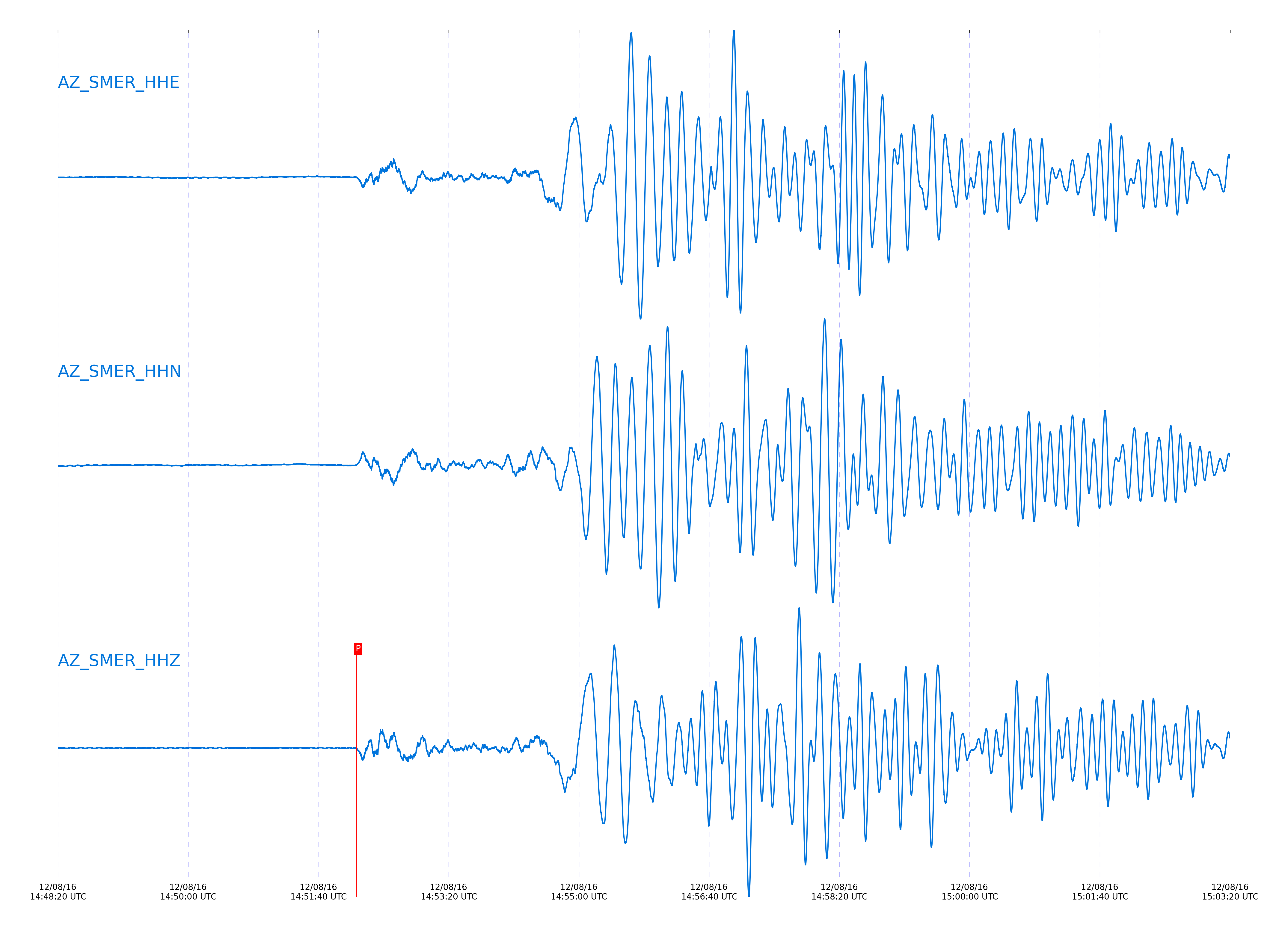
Closest station with identified signal. Not filtered.
Subset of several stations close to the event. Not filtered.
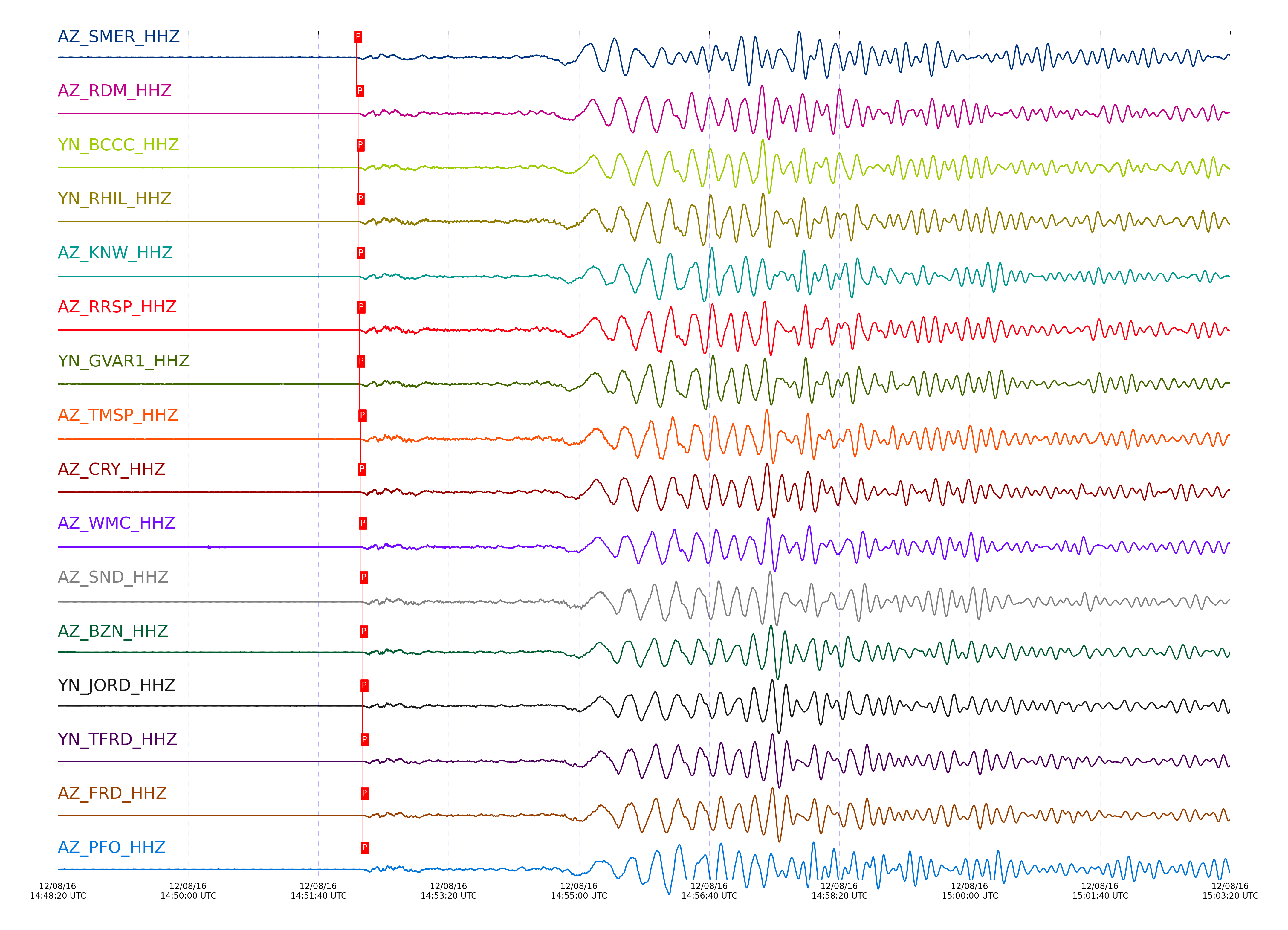
| STA_CHAN | S-E Delta | S-E Azimuth | Phase | Time | Signal/Noise | Time Residual | V. Model | Auth | arid |
|---|---|---|---|---|---|---|---|---|---|
| SMER_HHZ | 10.027° | 316.99° | Pn | 2016-12-08 14:52:09.0227 UTC | 46.405 | -1.515 | iasp91 | dbp:jtytell:163 | 1288195 |
| RDM_HHZ | 10.089° | 315.4° | Pn | 2016-12-08 14:52:10.6109 UTC | 83.326 | -0.776 | iasp91 | dbp:jtytell:163 | 1288196 |
| BCCC_HHZ | 10.099° | 315.23° | Pn | 2016-12-08 14:52:10.8258 UTC | 95.626 | -0.694 | iasp91 | dbp:jtytell:163 | 1288197 |
| RHIL_HHZ | 10.103° | 315.02° | Pn | 2016-12-08 14:52:10.8602 UTC | -1 | -0.721 | iasp91 | dbp:jtytell:163 | 1288325 |
| KNW_HHZ | 10.109° | 314.69° | Pn | 2016-12-08 14:52:11.1635 UTC | 74.225 | -0.502 | iasp91 | dbp:jtytell:163 | 1288200 |
| RRSP_HHZ | 10.137° | 315.02° | Pn | 2016-12-08 14:52:11.4181 UTC | -1 | -0.63 | iasp91 | dbp:jtytell:163 | 1288328 |
| GVAR1_HHZ | 10.146° | 314.87° | Pn | 2016-12-08 14:52:11.34 UTC | 63.876 | -0.83 | iasp91 | dbp:jtytell:163 | 1288214 |
| TMSP_HHZ | 10.194° | 314.99° | Pn | 2016-12-08 14:52:12.3274 UTC | -1 | -0.506 | iasp91 | dbp:jtytell:163 | 1288334 |
| CRY_HHZ | 10.199° | 315.35° | Pn | 2016-12-08 14:52:12.072 UTC | 122.78 | -0.83 | iasp91 | dbp:jtytell:163 | 1288199 |
| WMC_HHZ | 10.23° | 315.15° | Pn | 2016-12-08 14:52:12.6698 UTC | -1 | -0.655 | iasp91 | dbp:jtytell:163 | 1288332 |
| SND_HHZ | 10.282° | 315.06° | Pn | 2016-12-08 14:52:13.3679 UTC | 83.751 | -0.666 | iasp91 | dbp:jtytell:163 | 1288202 |
| BZN_HHZ | 10.293° | 315.45° | Pn | 2016-12-08 14:52:13.4769 UTC | 21.766 | -0.709 | iasp91 | dbp:jtytell:163 | 1288235 |
| JORD_HHZ | 10.32° | 315.46° | Pn | 2016-12-08 14:52:13.8198 UTC | 5.6738 | -0.731 | iasp91 | dbp:jtytell:163 | 1288204 |
| TFRD_HHZ | 10.329° | 315.26° | Pn | 2016-12-08 14:52:14.0522 UTC | -1 | -0.622 | iasp91 | dbp:jtytell:163 | 1288337 |
| FRD_HHZ | 10.329° | 315.26° | Pn | 2016-12-08 14:52:13.9659 UTC | 19.255 | -0.709 | iasp91 | dbp:jtytell:163 | 1288236 |
| PFO_HHZ | 10.331° | 314.42° | Pn | 2016-12-08 14:52:14.2099 UTC | -1 | -0.491 | iasp91 | dbp:jtytell:163 | 1288339 |
| TRO_HHZ | 10.413° | 314.68° | Pn | 2016-12-08 14:52:15.4373 UTC | 52.005 | -0.386 | iasp91 | dbp:jtytell:163 | 1288211 |
| LVA2_HHZ | 10.455° | 315.7° | Pn | 2016-12-08 14:52:15.806 UTC | 14.613 | -0.593 | iasp91 | dbp:jtytell:163 | 1288209 |
| CPE_HHZ | 10.486° | 318.91° | Pn | 2016-12-08 14:52:16.7364 UTC | 34.139 | -0.091 | iasp91 | dbp:jtytell:163 | 1288213 |
| TR01_HHZ | 10.491° | 315.03° | Pn | 2016-12-08 14:52:16.2117 UTC | -1 | -0.681 | iasp91 | dbp:jtytell:163 | 1288349 |
| TR02_HHZ | 10.492° | 315.06° | Pn | 2016-12-08 14:52:16.2297 UTC | -1 | -0.681 | iasp91 | dbp:jtytell:163 | 1288350 |
| TR03_HHZ | 10.495° | 315.11° | Pn | 2016-12-08 14:52:16.1445 UTC | -1 | -0.799 | iasp91 | dbp:jtytell:163 | 1288352 |
| TR04_HHZ | 10.501° | 315.15° | Pn | 2016-12-08 14:52:16.4331 UTC | -1 | -0.593 | iasp91 | dbp:jtytell:163 | 1288354 |
| MONP2_HHZ | 10.868° | 317.01° | Pn | 2016-12-08 14:52:21.4046 UTC | -1 | -0.649 | iasp91 | dbp:jtytell:163 | 1288362 |
Click the link below to observe an interactive map of earthquakes recorded by the station deployment:
Broadband Seismic Data Collection Center (ANZA),
Institute of Geophysics & Planetary Physics
Scripps Institution of Oceanography,
University of California San Diego
Copyright © 1989 - 2014. All Rights Reserved.