
last update to page: December 19 2016 17:41:06 (UTC).
SummaryThe red marker denotes the earthquake epicenter. On Sat Dec 17th 2016 10:51:12 (UTC) the seismic network recorded an earthquake (preliminary 7.9 mww) located in New Ireland Region, P.n.g.. Seismic region Bismarck And Solomon Islands. The epicentral distance (i.e. distance separating the location to the epicenter) to the closest station SCI2 in the network is 10,110.8 km. If you felt the quake, the USGS would like to know. Please add your comments to the USGS page "Did you feel it?". |
Details
Proximity to Population Centers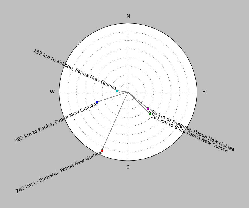
| ||||||||||||||||
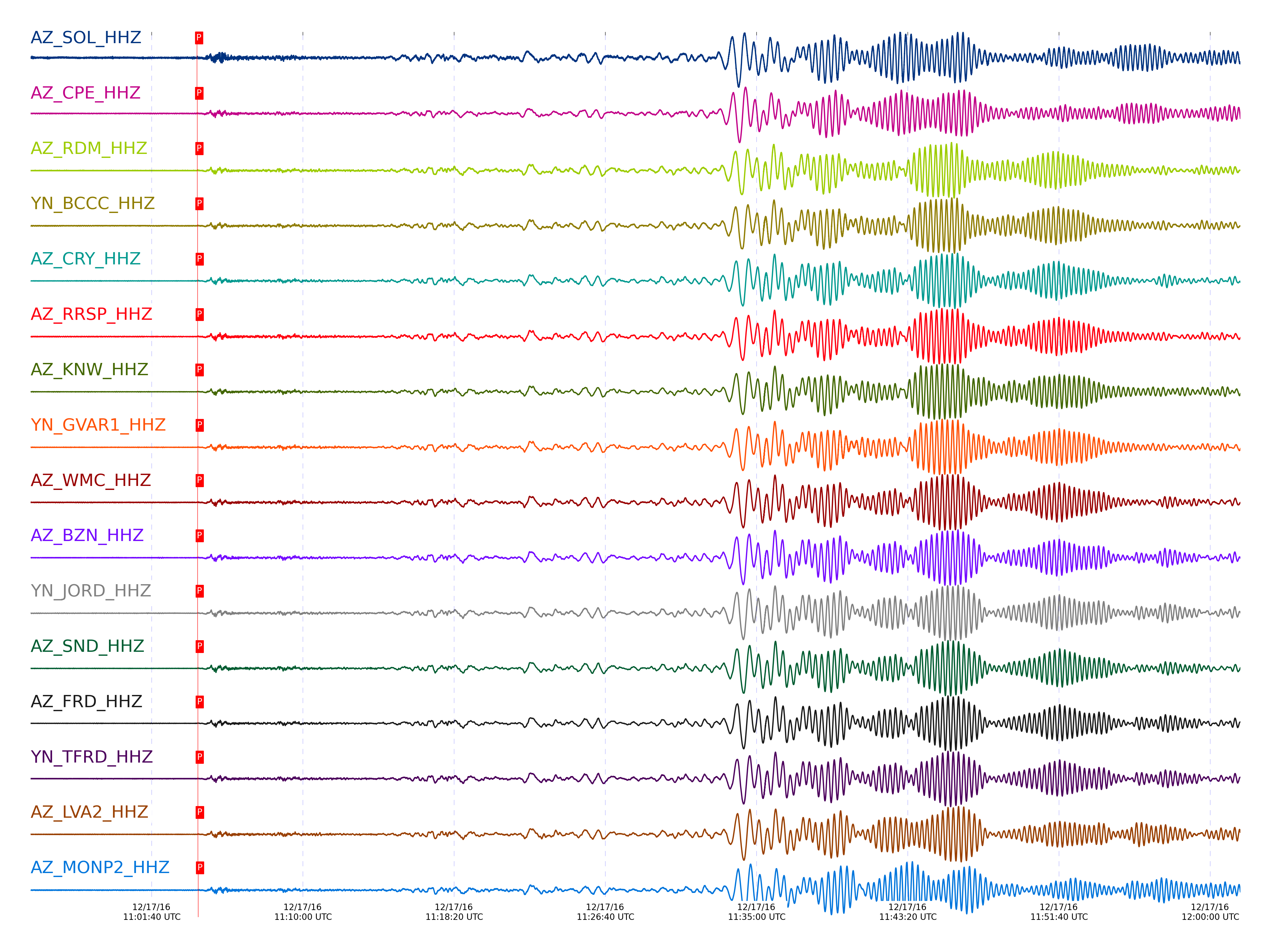
Event and active stations
|
|||||||||||||||||
Closest station with identified signal. Not filtered.

Subset of several stations close to the event. Not filtered.
| STA_CHAN | S-E Delta | S-E Azimuth | Phase | Time | Signal/Noise | Time Residual | V. Model | Auth | arid |
|---|---|---|---|---|---|---|---|---|---|
| SOL_HHZ | 91.859° | 265.83° | PcP | 2016-12-17 11:04:09.6891 UTC | -1 | 0.075 | iasp91 | dbp:jtytell:163 | 1296548 |
| CPE_HHZ | 91.982° | 265.91° | PcP | 2016-12-17 11:04:10.5551 UTC | -1 | 0.395 | iasp91 | dbp:jtytell:163 | 1296552 |
| RDM_HHZ | 92.248° | 266.08° | PcP | 2016-12-17 11:04:11.0866 UTC | -1 | -0.254 | iasp91 | dbp:jtytell:163 | 1296562 |
| BCCC_HHZ | 92.28° | 266.1° | PcP | 2016-12-17 11:04:11.3331 UTC | -1 | -0.149 | iasp91 | dbp:jtytell:163 | 1296563 |
| CRY_HHZ | 92.336° | 266.14° | PcP | 2016-12-17 11:04:11.7873 UTC | -1 | 0.059 | iasp91 | dbp:jtytell:163 | 1296567 |
| RRSP_HHZ | 92.34° | 266.14° | PcP | 2016-12-17 11:04:11.9052 UTC | -1 | 0.159 | iasp91 | dbp:jtytell:163 | 1296543 |
| KNW_HHZ | 92.367° | 266.16° | PcP | 2016-12-17 11:04:11.6321 UTC | -1 | -0.234 | iasp91 | dbp:jtytell:163 | 1296568 |
| GVAR1_HHZ | 92.368° | 266.16° | PcP | 2016-12-17 11:04:12.1843 UTC | -1 | 0.313 | iasp91 | dbp:jtytell:163 | 1296569 |
| WMC_HHZ | 92.389° | 266.17° | PcP | 2016-12-17 11:04:11.7311 UTC | -1 | -0.23 | iasp91 | dbp:jtytell:163 | 1296570 |
| BZN_HHZ | 92.389° | 266.17° | PcP | 2016-12-17 11:04:12.0832 UTC | -1 | 0.118 | iasp91 | dbp:jtytell:163 | 1296571 |
| JORD_HHZ | 92.406° | 266.18° | PcP | 2016-12-17 11:04:12.0621 UTC | -1 | 0.021 | iasp91 | dbp:jtytell:163 | 1296572 |
| SND_HHZ | 92.438° | 266.21° | PcP | 2016-12-17 11:04:12.3087 UTC | -1 | 0.126 | iasp91 | dbp:jtytell:163 | 1296576 |
| FRD_HHZ | 92.444° | 266.21° | PcP | 2016-12-17 11:04:12.3819 UTC | -1 | 0.177 | iasp91 | dbp:jtytell:163 | 1296579 |
| TFRD_HHZ | 92.444° | 266.21° | PcP | 2016-12-17 11:04:12.2826 UTC | -1 | 0.077 | iasp91 | dbp:jtytell:163 | 1296580 |
| LVA2_HHZ | 92.468° | 266.23° | PcP | 2016-12-17 11:04:12.5938 UTC | -1 | 0.28 | iasp91 | dbp:jtytell:163 | 1296582 |
| MONP2_HHZ | 92.554° | 266.28° | PcP | 2016-12-17 11:04:13.2888 UTC | -1 | 0.593 | iasp91 | dbp:jtytell:163 | 1296584 |
| TR04_HHZ | 92.584° | 266.3° | PcP | 2016-12-17 11:04:12.8788 UTC | -1 | 0.051 | iasp91 | dbp:jtytell:163 | 1296594 |
| TR03_HHZ | 92.587° | 266.3° | P | 2016-12-17 11:04:12.5445 UTC | -1 | 0.199 | iasp91 | dbp:jtytell:163 | 1296595 |
| TR02_HHZ | 92.593° | 266.31° | PcP | 2016-12-17 11:04:12.8701 UTC | -1 | 0.003 | iasp91 | dbp:jtytell:163 | 1296596 |
| TR01_HHZ | 92.596° | 266.31° | PcP | 2016-12-17 11:04:13.0332 UTC | -1 | 0.152 | iasp91 | dbp:jtytell:163 | 1296597 |
Click the link below to observe an interactive map of earthquakes recorded by the station deployment:
Broadband Seismic Data Collection Center (ANZA),
Institute of Geophysics & Planetary Physics
Scripps Institution of Oceanography,
University of California San Diego
Copyright © 1989 - 2014. All Rights Reserved.