
last update to page: December 28 2016 20:11:48 (UTC).
SummaryThe red marker denotes the earthquake epicenter. On Wed Dec 28th 2016 17:56:59 (UTC) the seismic network recorded an earthquake (preliminary 3.92 mw) located in Southern California. Seismic region California - Nevada Region. The epicentral distance (i.e. distance separating the location to the epicenter) to the closest station WRDG in the network is 46.8 km. If you felt the quake, the USGS would like to know. Please add your comments to the USGS page "Did you feel it?". |
Details
Proximity to Population Centers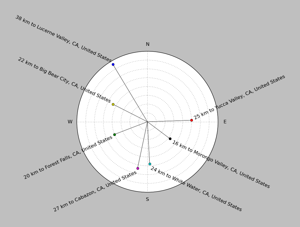
| ||||||||||||||||
Event and active stations
|
|||||||||||||||||
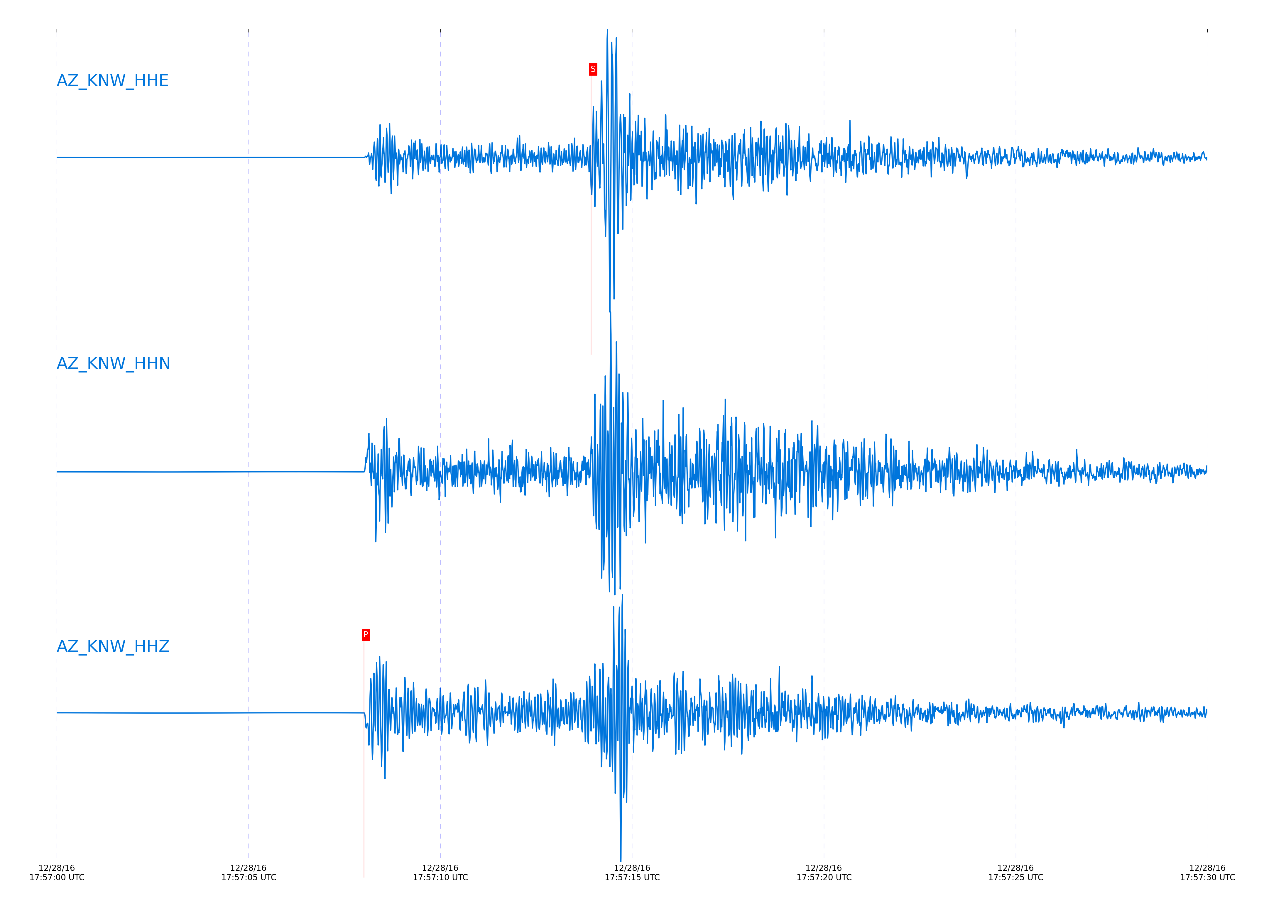
Closest station with identified signal. Not filtered.
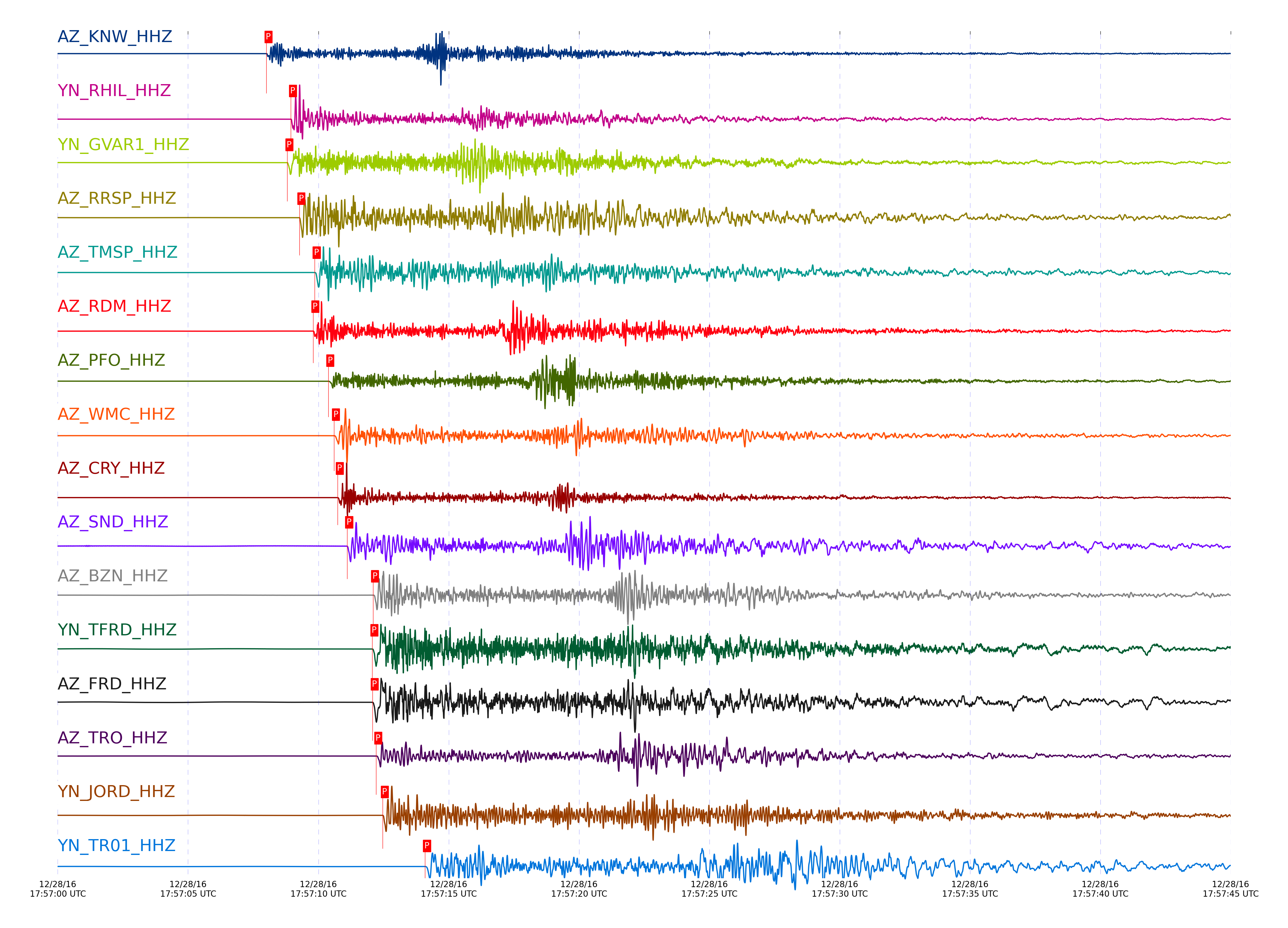
Subset of several stations close to the event. Not filtered.
| STA_CHAN | S-E Delta | S-E Azimuth | Phase | Time | Signal/Noise | Time Residual | V. Model | Auth | arid |
|---|---|---|---|---|---|---|---|---|---|
| KNW_HHZ | 0.437° | 0.51° | Pg | 2016-12-28 17:57:08.0057 UTC | 7466.9 | -0.411 | iasp91 | dbp:jtytell:163 | 1306522 |
| KNW_HHE | 0.437° | 0.51° | Sg | 2016-12-28 17:57:13.9237 UTC | -1 | -0.743 | iasp91 | dbp:jtytell:163 | 1306871 |
| RHIL_HHZ | 0.481° | 6.33° | Pg | 2016-12-28 17:57:08.9466 UTC | -1 | -0.295 | iasp91 | dbp:jtytell:163 | 1306778 |
| GVAR1_HHZ | 0.485° | 359.94° | Pg | 2016-12-28 17:57:08.8095 UTC | 1533.9 | -0.506 | iasp91 | dbp:jtytell:163 | 1306524 |
| RRSP_HHZ | 0.501° | 3.05° | Pg | 2016-12-28 17:57:09.2694 UTC | -1 | -0.339 | iasp91 | dbp:jtytell:163 | 1306785 |
| RRSP_HHN | 0.501° | 3.05° | Sg | 2016-12-28 17:57:16.2166 UTC | -1 | -0.505 | iasp91 | dbp:jtytell:163 | 1306875 |
| TMSP_HHZ | 0.533° | 357.66° | Pg | 2016-12-28 17:57:09.8567 UTC | -1 | -0.356 | iasp91 | dbp:jtytell:163 | 1306784 |
| RDM_HHZ | 0.534° | 12.58° | Pg | 2016-12-28 17:57:09.8053 UTC | 1092.9 | -0.438 | iasp91 | dbp:jtytell:163 | 1306525 |
| RDM_HHN | 0.534° | 12.58° | Sg | 2016-12-28 17:57:16.9622 UTC | -1 | -0.855 | iasp91 | dbp:jtytell:163 | 1306877 |
| PFO_HHZ | 0.577° | 339.2° | Pg | 2016-12-28 17:57:10.3784 UTC | 1584.9 | -0.683 | iasp91 | dbp:jtytell:163 | 1306527 |
| WMC_HHZ | 0.578° | 357.33° | Pg | 2016-12-28 17:57:10.5958 UTC | 1488.8 | -0.481 | iasp91 | dbp:jtytell:163 | 1306528 |
| CRY_HHZ | 0.586° | 2.43° | Pg | 2016-12-28 17:57:10.7389 UTC | 1589.8 | -0.491 | iasp91 | dbp:jtytell:163 | 1306531 |
| CRY_HHN | 0.586° | 2.43° | Sg | 2016-12-28 17:57:18.7897 UTC | -1 | -0.729 | iasp91 | dbp:jtytell:163 | 1306888 |
| SND_HHZ | 0.604° | 352.58° | Pg | 2016-12-28 17:57:11.1039 UTC | 118.52 | -0.468 | iasp91 | dbp:jtytell:163 | 1306532 |
| SND_HHE | 0.604° | 352.58° | Sg | 2016-12-28 17:57:19.6126 UTC | -1 | -0.495 | iasp91 | dbp:jtytell:163 | 1306889 |
| BZN_HHZ | 0.661° | 357.11° | Pg | 2016-12-28 17:57:12.0965 UTC | 1178.1 | -0.538 | iasp91 | dbp:jtytell:163 | 1306539 |
| BZN_HHN | 0.661° | 357.11° | Sg | 2016-12-28 17:57:21.0931 UTC | -1 | -0.848 | iasp91 | dbp:jtytell:163 | 1306892 |
| TFRD_HHZ | 0.662° | 352.46° | Pg | 2016-12-28 17:57:12.0703 UTC | -1 | -0.595 | iasp91 | dbp:jtytell:163 | 1306804 |
| FRD_HHZ | 0.662° | 352.46° | Pg | 2016-12-28 17:57:12.0784 UTC | 2035.5 | -0.589 | iasp91 | dbp:jtytell:163 | 1306536 |
| FRD_HHE | 0.662° | 352.46° | Sg | 2016-12-28 17:57:21.004 UTC | -1 | -0.994 | iasp91 | dbp:jtytell:163 | 1306893 |
| TRO_HHZ | 0.67° | 339.65° | Pg | 2016-12-28 17:57:12.2184 UTC | 1163.5 | -0.594 | iasp91 | dbp:jtytell:163 | 1306541 |
| TRO_HHE | 0.67° | 339.65° | Sg | 2016-12-28 17:57:21.0051 UTC | -1 | -1.243 | iasp91 | dbp:jtytell:163 | 1306895 |
| JORD_HHZ | 0.681° | 355.67° | Pg | 2016-12-28 17:57:12.4695 UTC | 1596.1 | -0.552 | iasp91 | dbp:jtytell:163 | 1306545 |
| TR01_HHZ | 0.768° | 341.55° | Pg | 2016-12-28 17:57:14.0895 UTC | 3484.2 | -0.585 | iasp91 | dbp:jtytell:163 | 1306556 |
| TR01_HHN | 0.768° | 341.55° | Sg | 2016-12-28 17:57:24.5167 UTC | -1 | -0.944 | iasp91 | dbp:jtytell:163 | 1306901 |
| TR02_HHZ | 0.772° | 341.86° | Pg | 2016-12-28 17:57:14.1527 UTC | -1 | -0.589 | iasp91 | dbp:jtytell:163 | 1306808 |
| TR02_HHE | 0.772° | 341.86° | Sg | 2016-12-28 17:57:24.3982 UTC | -1 | -1.177 | iasp91 | dbp:jtytell:163 | 1306902 |
| TR03_HHZ | 0.778° | 342.43° | Pg | 2016-12-28 17:57:14.2399 UTC | -1 | -0.629 | iasp91 | dbp:jtytell:163 | 1306833 |
| TR04_HHZ | 0.788° | 342.82° | Pg | 2016-12-28 17:57:14.525 UTC | -1 | -0.525 | iasp91 | dbp:jtytell:163 | 1306811 |
| SMER_HHZ | 0.793° | 28.92° | Pg | 2016-12-28 17:57:14.1754 UTC | 117.41 | -0.978 | iasp91 | dbp:jtytell:163 | 1306557 |
| SMER_HHN | 0.793° | 28.92° | Sg | 2016-12-28 17:57:24.3783 UTC | -1 | -1.907 | iasp91 | dbp:jtytell:163 | 1306904 |
| LVA2_HHZ | 0.809° | 351.43° | Pg | 2016-12-28 17:57:14.7931 UTC | 3197.5 | -0.653 | iasp91 | dbp:jtytell:163 | 1306558 |
| LVA2_HHN | 0.809° | 351.43° | Sg | 2016-12-28 17:57:25.3496 UTC | -1 | -1.441 | iasp91 | dbp:jtytell:163 | 1306906 |
| MONP2_HHZ | 1.282° | 349.4° | Pn | 2016-12-28 17:57:22.7171 UTC | 134.7 | -0.947 | iasp91 | dbp:jtytell:163 | 1306571 |
| CPE_HHZ | 1.305° | 14.61° | Pn | 2016-12-28 17:57:22.6184 UTC | 108.46 | -1.373 | iasp91 | dbp:jtytell:163 | 1306570 |
| CPE_HHN | 1.305° | 14.61° | Sn | 2016-12-28 17:57:39.1506 UTC | -1 | -3.071 | iasp91 | dbp:jtytell:163 | 1306922 |
| SOL_HHZ | 1.386° | 18.84° | Pn | 2016-12-28 17:57:24.2087 UTC | 16.443 | -0.889 | iasp91 | dbp:jtytell:163 | 1306583 |
| SOL_HHN | 1.386° | 18.84° | Sn | 2016-12-28 17:57:42.2305 UTC | -1 | -1.982 | iasp91 | dbp:jtytell:163 | 1306923 |
Click the link below to observe an interactive map of earthquakes recorded by the station deployment:
Broadband Seismic Data Collection Center (ANZA),
Institute of Geophysics & Planetary Physics
Scripps Institution of Oceanography,
University of California San Diego
Copyright © 1989 - 2014. All Rights Reserved.