
last update to page: January 31 2017 23:33:34 (UTC).
SummaryThe red marker denotes the earthquake epicenter. On Tue Jan 31st 2017 09:38:37 (UTC) the seismic network recorded an earthquake (preliminary 5.2 ml) located in Central Alaska. Seismic region Alaska - Aleutian Arc. The epicentral distance (i.e. distance separating the location to the epicenter) to the closest station CSLB in the network is 3,975.2 km. If you felt the quake, the USGS would like to know. Please add your comments to the USGS page "Did you feel it?". |
Details
Proximity to Population Centers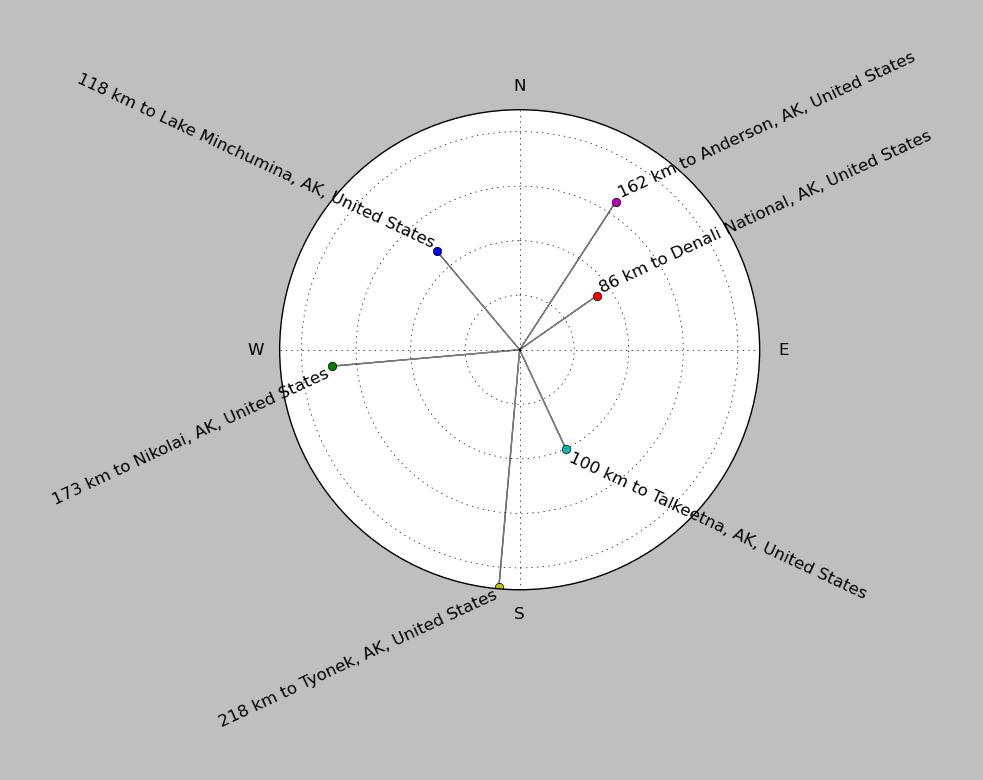
| ||||||||||||||||
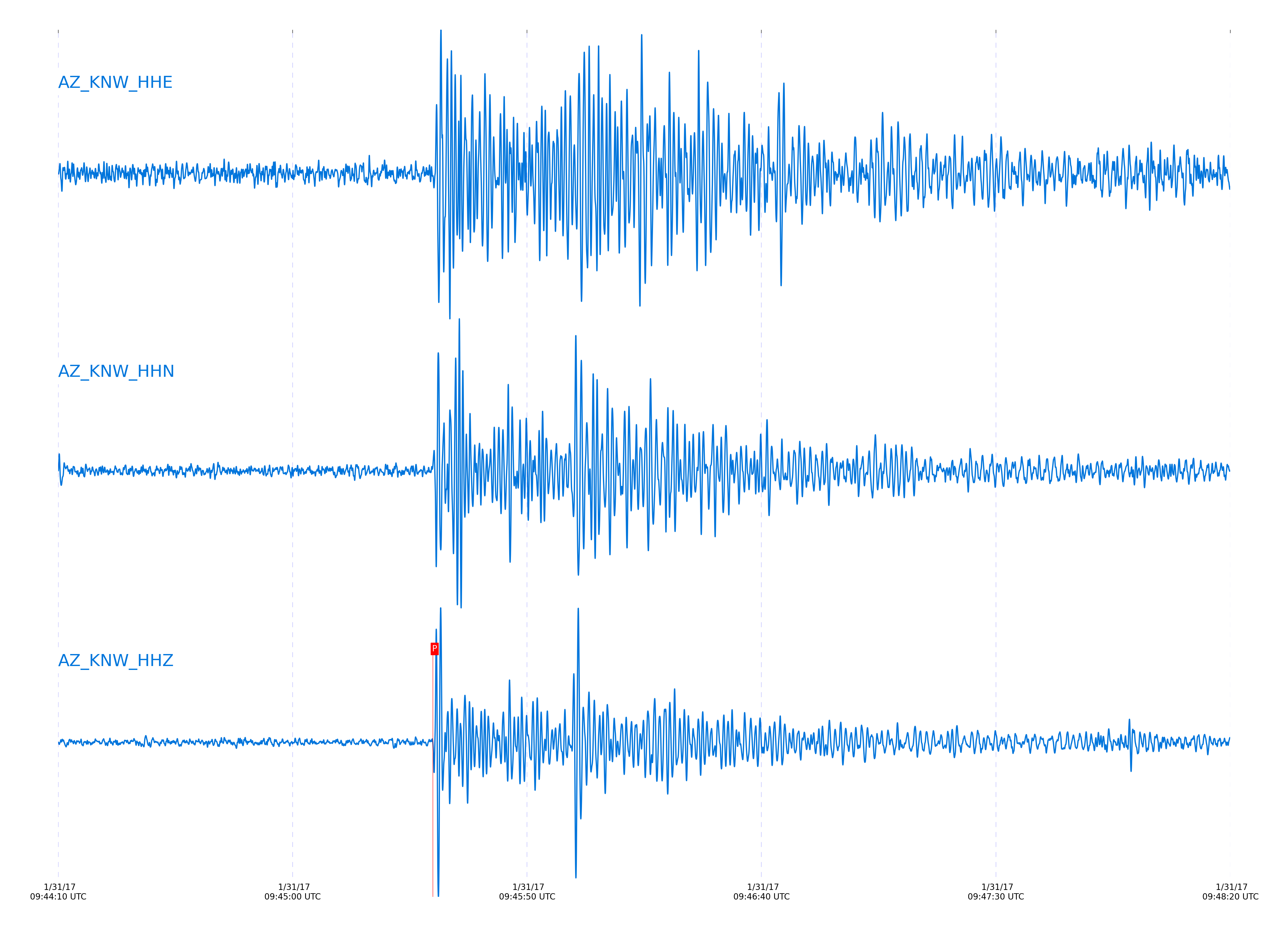
Event and active stations
|
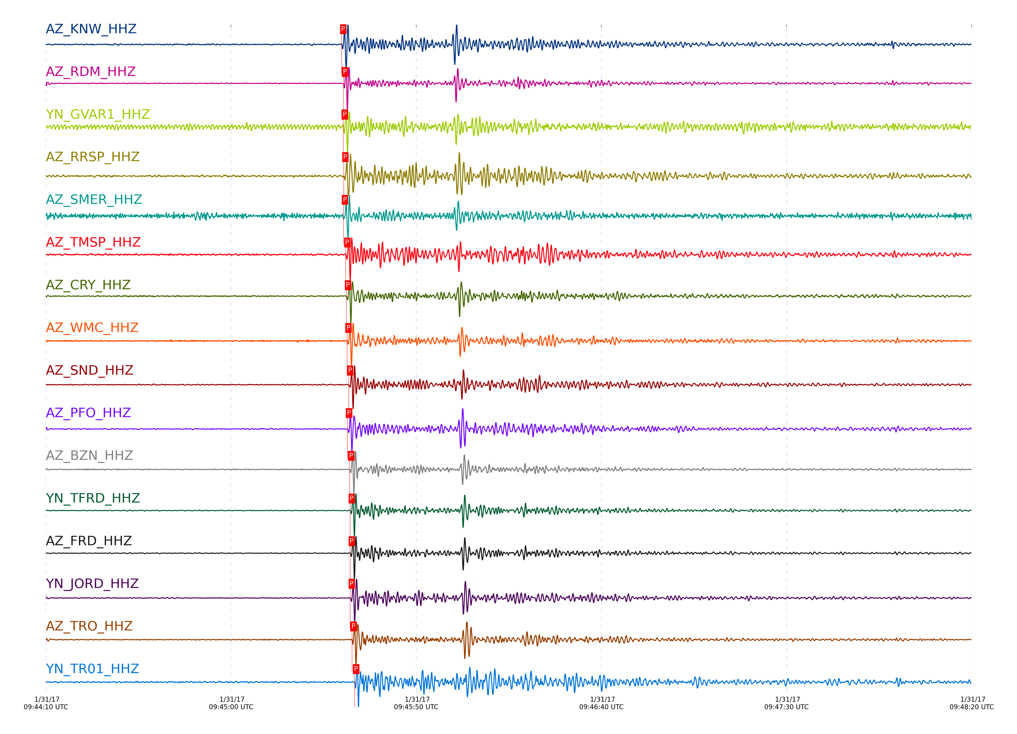
|||||||||||||||||
Closest station with identified signal. 0.8 to 3 Hz bandpass Butterworth filter has been applied to data.
Subset of several stations close to the event. 0.8 to 3 Hz bandpass Butterworth filter has been applied to data.
| STA_CHAN | S-E Delta | S-E Azimuth | Phase | Time | Signal/Noise | Time Residual | V. Model | Auth | arid |
|---|---|---|---|---|---|---|---|---|---|
| KNW_HHZ | 36.265° | 334.49° | P | 2017-01-31 09:45:29.8959 UTC | 11.569 | 2.49 | iasp91 | dbp:jtytell:170 | 1332926 |
| RDM_HHZ | 36.293° | 334.6° | P | 2017-01-31 09:45:30.3672 UTC | 18.015 | 2.73 | iasp91 | dbp:jtytell:170 | 1332928 |
| GVAR1_HHZ | 36.31° | 334.51° | P | 2017-01-31 09:45:30.326 UTC | -1 | 2.538 | iasp91 | dbp:jtytell:170 | 1333512 |
| RRSP_HHZ | 36.312° | 334.54° | P | 2017-01-31 09:45:30.4834 UTC | -1 | 2.682 | iasp91 | dbp:jtytell:170 | 1333513 |
| SMER_HHZ | 36.333° | 334.85° | P | 2017-01-31 09:45:30.3787 UTC | 7.6641 | 2.394 | iasp91 | dbp:jtytell:170 | 1332930 |
| TMSP_HHZ | 36.362° | 334.53° | P | 2017-01-31 09:45:30.9804 UTC | -1 | 2.753 | iasp91 | dbp:jtytell:170 | 1333515 |
| CRY_HHZ | 36.39° | 334.59° | P | 2017-01-31 09:45:31.1733 UTC | 16.236 | 2.706 | iasp91 | dbp:jtytell:170 | 1332936 |
| WMC_HHZ | 36.405° | 334.55° | P | 2017-01-31 09:45:31.3244 UTC | 15.941 | 2.73 | iasp91 | dbp:jtytell:170 | 1332934 |
| SND_HHZ | 36.447° | 334.53° | P | 2017-01-31 09:45:31.774 UTC | 14.919 | 2.825 | iasp91 | dbp:jtytell:170 | 1332938 |
| PFO_HHZ | 36.448° | 334.43° | P | 2017-01-31 09:45:31.4722 UTC | 13.429 | 2.514 | iasp91 | dbp:jtytell:170 | 1332932 |
| BZN_HHZ | 36.482° | 334.6° | P | 2017-01-31 09:45:32.0482 UTC | 16.68 | 2.801 | iasp91 | dbp:jtytell:170 | 1332939 |
| TFRD_HHZ | 36.502° | 334.56° | P | 2017-01-31 09:45:32.1955 UTC | -1 | 2.777 | iasp91 | dbp:jtytell:170 | 1333526 |
| FRD_HHZ | 36.503° | 334.56° | P | 2017-01-31 09:45:32.1963 UTC | 15.424 | 2.777 | iasp91 | dbp:jtytell:170 | 1332940 |
| JORD_HHZ | 36.508° | 334.6° | P | 2017-01-31 09:45:32.1908 UTC | -1 | 2.73 | iasp91 | dbp:jtytell:170 | 1333528 |
| TRO_HHZ | 36.54° | 334.46° | P | 2017-01-31 09:45:32.6809 UTC | 23.778 | 2.945 | iasp91 | dbp:jtytell:170 | 1332941 |
| TR01_HHZ | 36.635° | 334.52° | P | 2017-01-31 09:45:33.3904 UTC | -1 | 2.849 | iasp91 | dbp:jtytell:170 | 1333538 |
| TR02_HHZ | 36.638° | 334.52° | P | 2017-01-31 09:45:33.3437 UTC | -1 | 2.777 | iasp91 | dbp:jtytell:170 | 1333539 |
| TR03_HHZ | 36.644° | 334.53° | P | 2017-01-31 09:45:33.3911 UTC | -1 | 2.777 | iasp91 | dbp:jtytell:170 | 1333540 |
| LVA2_HHZ | 36.646° | 334.63° | P | 2017-01-31 09:45:33.606 UTC | -1 | 2.969 | iasp91 | dbp:jtytell:170 | 1333541 |
| TR04_HHZ | 36.652° | 334.54° | P | 2017-01-31 09:45:33.6084 UTC | -1 | 2.921 | iasp91 | dbp:jtytell:170 | 1333542 |
| CPE_HHZ | 36.872° | 335.14° | P | 2017-01-31 09:45:35.5871 UTC | -1 | 3.041 | iasp91 | dbp:jtytell:170 | 1333545 |
| MONP2_HHZ | 37.112° | 334.82° | P | 2017-01-31 09:45:37.85 UTC | -1 | 3.28 | iasp91 | dbp:jtytell:170 | 1333550 |
Click the link below to observe an interactive map of earthquakes recorded by the station deployment:
Broadband Seismic Data Collection Center (ANZA),
Institute of Geophysics & Planetary Physics
Scripps Institution of Oceanography,
University of California San Diego
Copyright © 1989 - 2014. All Rights Reserved.