
last update to page: April 03 2017 18:52:04 (UTC).
SummaryThe red marker denotes the earthquake epicenter. On Mon Apr 3rd 2017 17:40:15 (UTC) the seismic network recorded an earthquake (preliminary 6.5 mwb) located in Botswana. Seismic region Africa. The epicentral distance (i.e. distance separating the location to the epicenter) to the closest station USGCB in the network is 16,074.6 km. If you felt the quake, the USGS would like to know. Please add your comments to the USGS page "Did you feel it?". |
Details
Proximity to Population Centers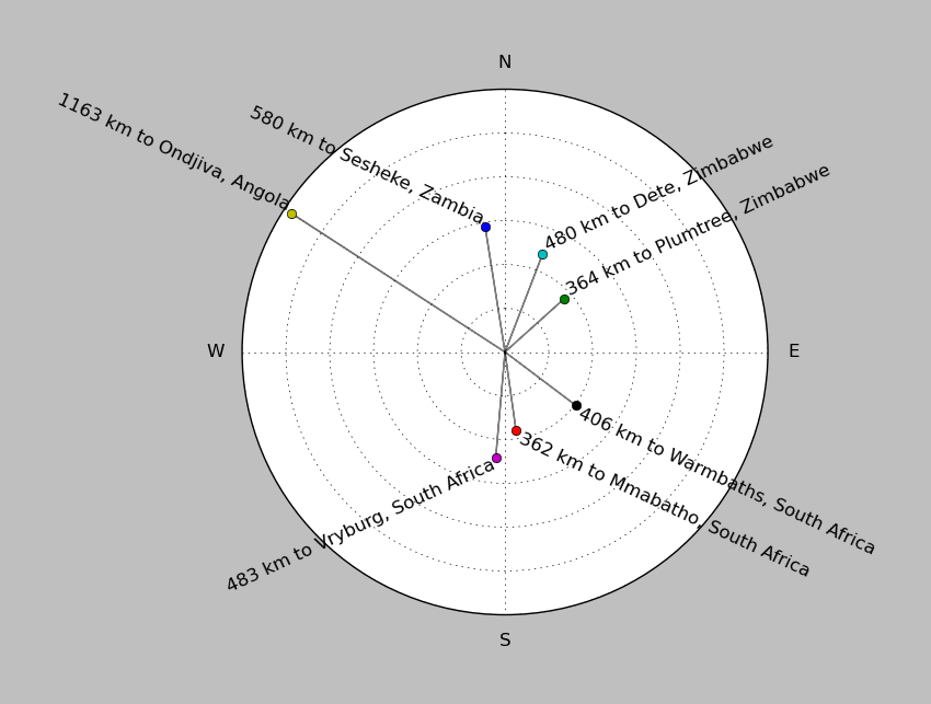
| ||||||||||||||||
Event and active stations
|
|||||||||||||||||
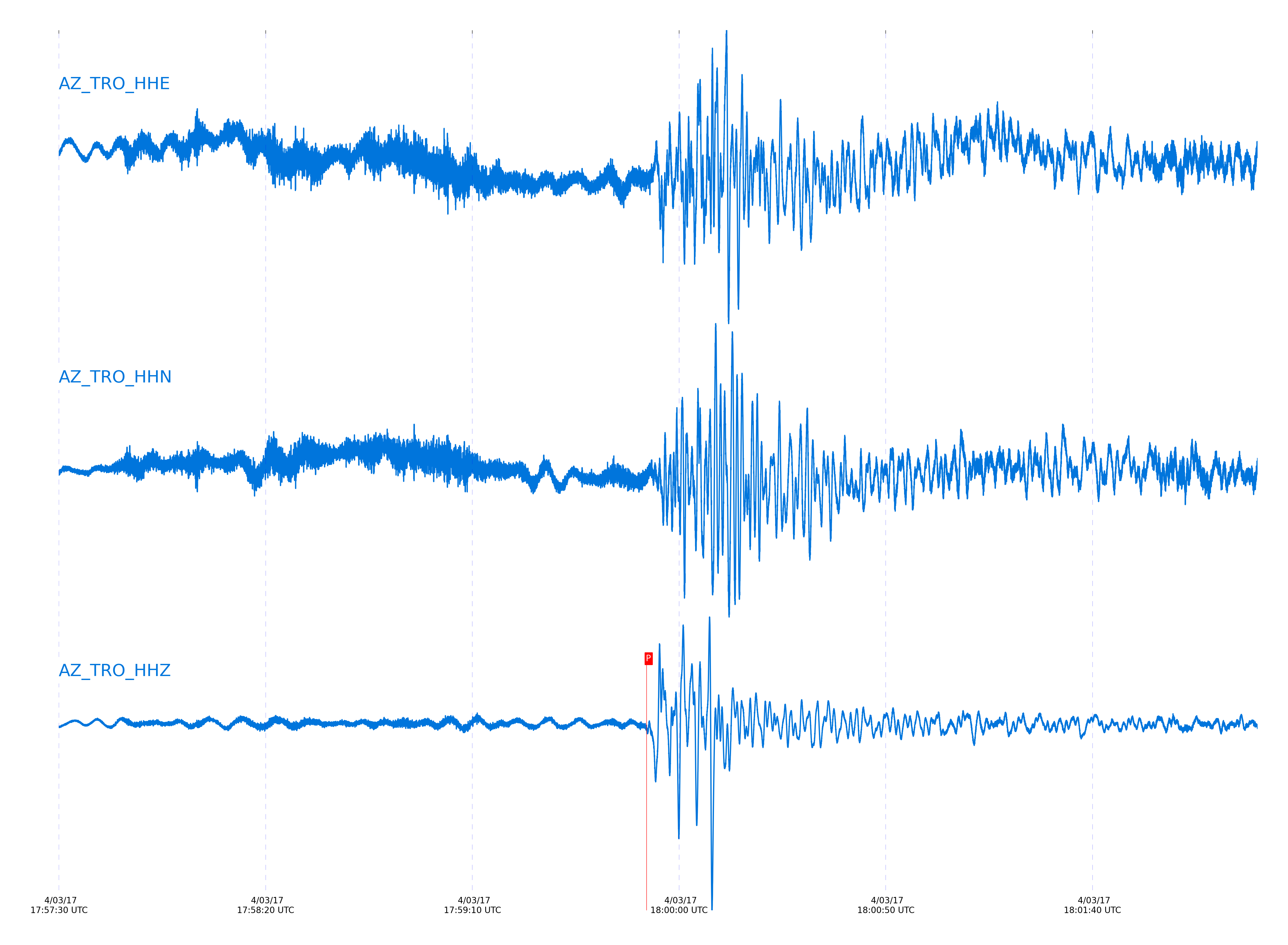
Closest station with identified signal. Not filtered.
Subset of several stations close to the event. Not filtered.
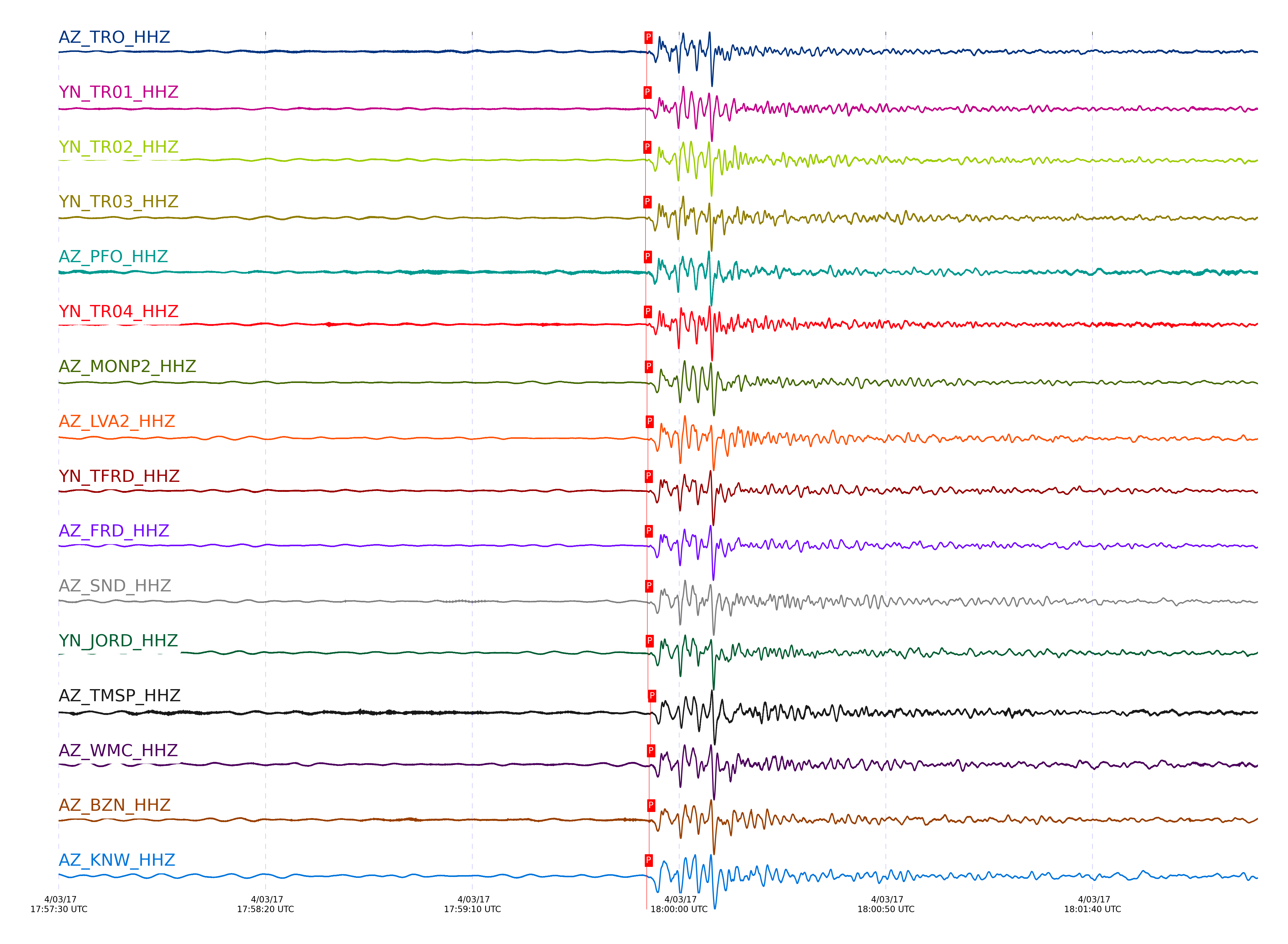
| STA_CHAN | S-E Delta | S-E Azimuth | Phase | Time | Signal/Noise | Time Residual | V. Model | Auth | arid |
|---|---|---|---|---|---|---|---|---|---|
| TRO_HHZ | 144.619° | 82.18° | PKPdf | 2017-04-03 17:59:52.1603 UTC | 310.16 | 0.603 | iasp91 | dbp:jtytell:170 | 1370342 |
| TR01_HHZ | 144.622° | 82.33° | PKPdf | 2017-04-03 17:59:51.8947 UTC | -1 | 0.332 | iasp91 | dbp:jtytell:170 | 1370474 |
| TR02_HHZ | 144.626° | 82.34° | PKPdf | 2017-04-03 17:59:51.8599 UTC | -1 | 0.291 | iasp91 | dbp:jtytell:170 | 1370475 |
| TR03_HHZ | 144.632° | 82.34° | PKPdf | 2017-04-03 17:59:51.8823 UTC | -1 | 0.303 | iasp91 | dbp:jtytell:170 | 1370479 |
| PFO_HHZ | 144.635° | 82.04° | PKPdf | 2017-04-03 17:59:51.9829 UTC | 141.11 | 0.399 | iasp91 | dbp:jtytell:170 | 1370344 |
| TR04_HHZ | 144.636° | 82.36° | PKPdf | 2017-04-03 17:59:52.0106 UTC | -1 | 0.425 | iasp91 | dbp:jtytell:170 | 1370482 |
| MONP2_HHZ | 144.697° | 83.07° | PKPdf | 2017-04-03 17:59:52.219 UTC | -1 | 0.528 | iasp91 | dbp:jtytell:170 | 1370487 |
| LVA2_HHZ | 144.754° | 82.33° | PKPdf | 2017-04-03 17:59:52.4353 UTC | 286.44 | 0.647 | iasp91 | dbp:jtytell:170 | 1370341 |
| TFRD_HHZ | 144.769° | 82.1° | PKPdf | 2017-04-03 17:59:52.2043 UTC | -1 | 0.391 | iasp91 | dbp:jtytell:170 | 1370491 |
| FRD_HHZ | 144.769° | 82.1° | PKPdf | 2017-04-03 17:59:52.2287 UTC | 206.95 | 0.416 | iasp91 | dbp:jtytell:170 | 1370343 |
| SND_HHZ | 144.77° | 82.01° | PKPdf | 2017-04-03 17:59:52.3069 UTC | -1 | 0.492 | iasp91 | dbp:jtytell:170 | 1370493 |
| JORD_HHZ | 144.807° | 82.1° | PKPdf | 2017-04-03 17:59:52.4325 UTC | -1 | 0.554 | iasp91 | dbp:jtytell:170 | 1370496 |
| TMSP_HHZ | 144.816° | 81.87° | PKPdf | 2017-04-03 17:59:53.0266 UTC | -1 | 1.132 | iasp91 | dbp:jtytell:170 | 1370499 |
| WMC_HHZ | 144.818° | 81.93° | PKPdf | 2017-04-03 17:59:52.7492 UTC | -1 | 0.853 | iasp91 | dbp:jtytell:170 | 1370497 |
| BZN_HHZ | 144.823° | 82.06° | PKPdf | 2017-04-03 17:59:52.7661 UTC | 162.1 | 0.861 | iasp91 | dbp:jtytell:170 | 1370346 |
| KNW_HHZ | 144.828° | 81.71° | PKPdf | 2017-04-03 17:59:52.2046 UTC | -1 | 0.29 | iasp91 | dbp:jtytell:170 | 1370500 |
| GVAR1_HHZ | 144.831° | 81.78° | PKPdf | 2017-04-03 17:59:52.3289 UTC | -1 | 0.41 | iasp91 | dbp:jtytell:170 | 1370501 |
| RRSP_HHZ | 144.86° | 81.78° | PKPdf | 2017-04-03 17:59:52.5419 UTC | -1 | 0.573 | iasp91 | dbp:jtytell:170 | 1370504 |
| CRY_HHZ | 144.87° | 81.9° | PKPdf | 2017-04-03 17:59:52.3779 UTC | 311.22 | 0.391 | iasp91 | dbp:jtytell:170 | 1370347 |
| RHIL_HHZ | 144.883° | 81.72° | PKPdf | 2017-04-03 17:59:52.5882 UTC | -1 | 0.58 | iasp91 | dbp:jtytell:170 | 1370524 |
| RDM_HHZ | 144.952° | 81.73° | PKPdf | 2017-04-03 17:59:52.6153 UTC | -1 | 0.489 | iasp91 | dbp:jtytell:170 | 1370507 |
| SMER_HHZ | 145.243° | 81.74° | PKPdf | 2017-04-03 17:59:53.4779 UTC | -1 | 0.856 | iasp91 | dbp:jtytell:170 | 1370515 |
| CPE_HHZ | 145.266° | 82.6° | PKPdf | 2017-04-03 17:59:54.2302 UTC | 230.55 | 1.569 | iasp91 | dbp:jtytell:170 | 1370348 |
Click the link below to observe an interactive map of earthquakes recorded by the station deployment:
Broadband Seismic Data Collection Center (ANZA),
Institute of Geophysics & Planetary Physics
Scripps Institution of Oceanography,
University of California San Diego
Copyright © 1989 - 2014. All Rights Reserved.