
last update to page: April 25 2017 16:51:47 (UTC).
SummaryThe red marker denotes the earthquake epicenter. On Mon Apr 24th 2017 21:38:26 (UTC) the seismic network recorded an earthquake (preliminary 6.9 mww) located in Off Coast Of Central Chile. Seismic region Andean South America. The epicentral distance (i.e. distance separating the location to the epicenter) to the closest station USGCB in the network is 8,684.8 km. If you felt the quake, the USGS would like to know. Please add your comments to the USGS page "Did you feel it?". |
Details
Proximity to Population Centers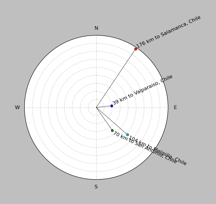
| ||||||||||||||||
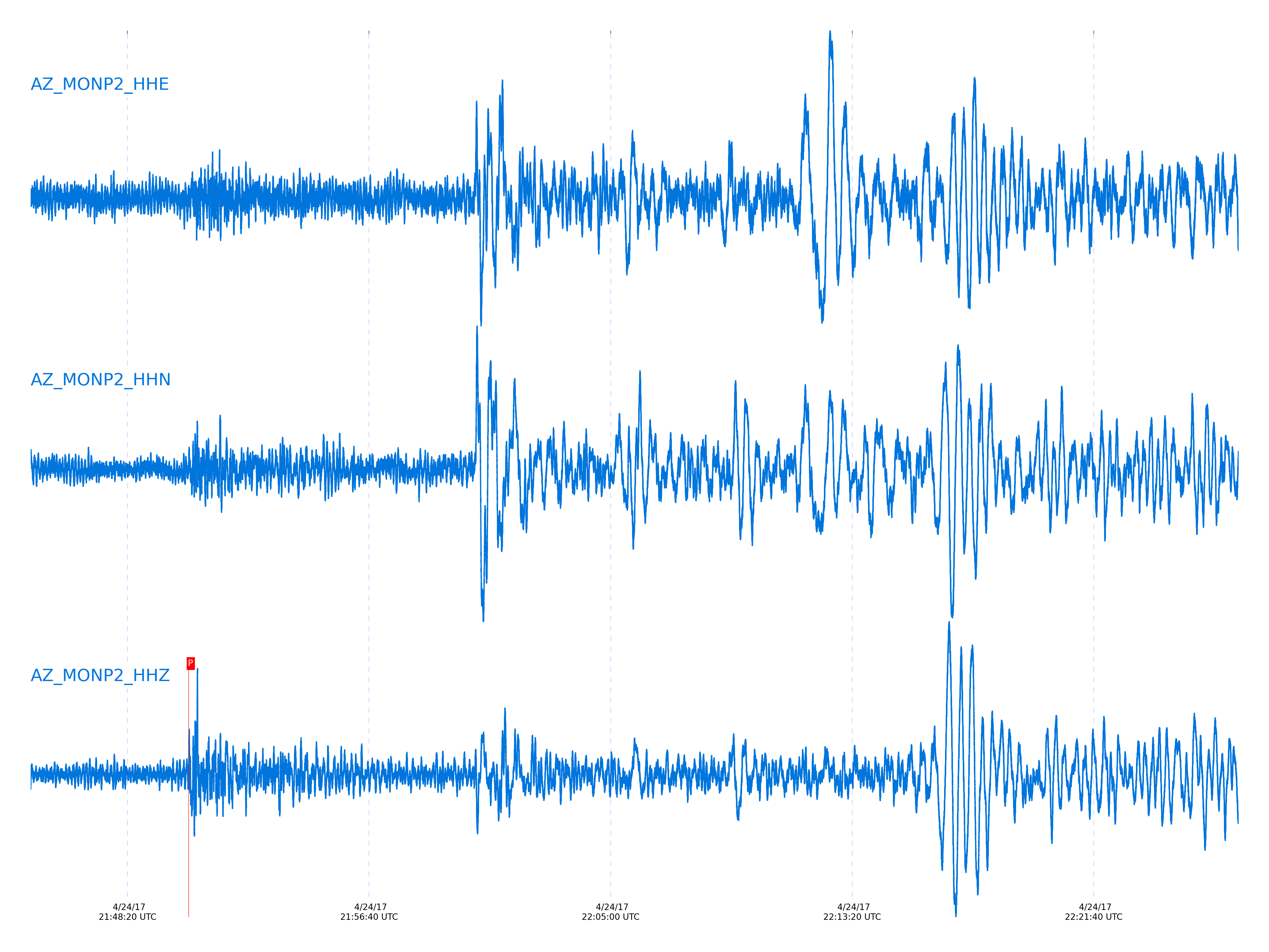
Event and active stations
|
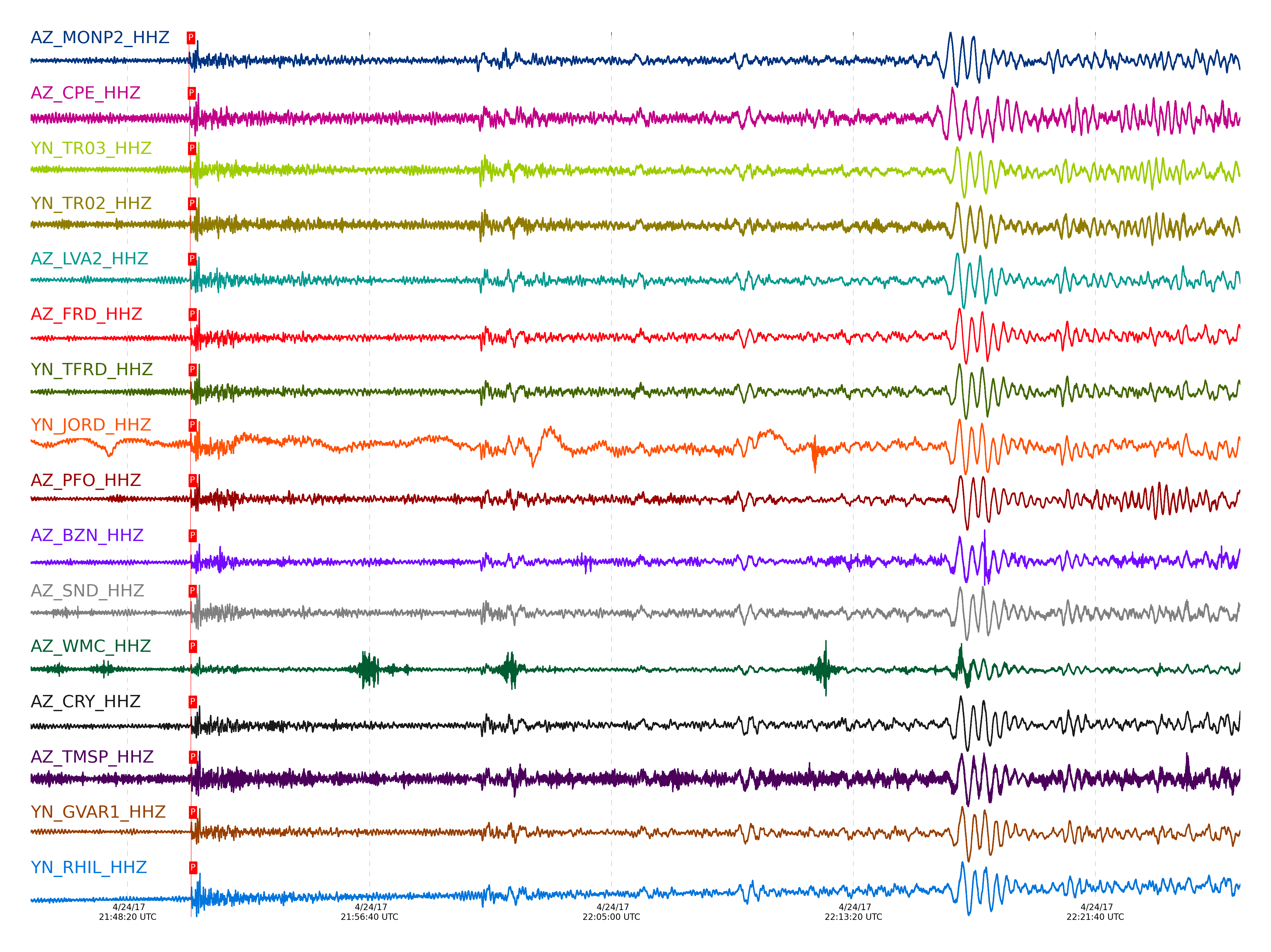
|||||||||||||||||
Closest station with identified signal. Not filtered.
Subset of several stations close to the event. Not filtered.
| STA_CHAN | S-E Delta | S-E Azimuth | Phase | Time | Signal/Noise | Time Residual | V. Model | Auth | arid |
|---|---|---|---|---|---|---|---|---|---|
| MONP2_HHZ | 78.075° | 143.21° | pP | 2017-04-24 21:50:26.9947 UTC | -1 | -3.847 | iasp91 | dbp:jtytell:171 | 1384791 |
| CPE_HHZ | 78.418° | 142.74° | P | 2017-04-24 21:50:28.4957 UTC | -1 | 3.813 | iasp91 | dbp:jtytell:171 | 1384797 |
| TR03_HHZ | 78.49° | 143.27° | pP | 2017-04-24 21:50:29.3408 UTC | -1 | -3.8 | iasp91 | dbp:jtytell:171 | 1384800 |
| TR02_HHZ | 78.494° | 143.28° | pP | 2017-04-24 21:50:29.3618 UTC | -1 | -3.8 | iasp91 | dbp:jtytell:171 | 1384801 |
| LVA2_HHZ | 78.513° | 143.17° | pP | 2017-04-24 21:50:29.516 UTC | -1 | -3.751 | iasp91 | dbp:jtytell:171 | 1384802 |
| FRD_HHZ | 78.647° | 143.16° | pP | 2017-04-24 21:50:30.3587 UTC | -1 | -3.652 | iasp91 | dbp:jtytell:171 | 1384805 |
| TFRD_HHZ | 78.648° | 143.16° | pP | 2017-04-24 21:50:30.2598 UTC | -1 | -3.751 | iasp91 | dbp:jtytell:171 | 1384806 |
| JORD_HHZ | 78.651° | 143.13° | pP | 2017-04-24 21:50:30.2782 UTC | -1 | -3.751 | iasp91 | dbp:jtytell:171 | 1384808 |
| PFO_HHZ | 78.67° | 143.27° | pP | 2017-04-24 21:50:30.3826 UTC | -1 | -3.752 | iasp91 | dbp:jtytell:171 | 1384814 |
| BZN_HHZ | 78.677° | 143.11° | pP | 2017-04-24 21:50:30.5232 UTC | -1 | -3.652 | iasp91 | dbp:jtytell:171 | 1384817 |
| SND_HHZ | 78.699° | 143.16° | pP | 2017-04-24 21:50:30.4413 UTC | -1 | -3.851 | iasp91 | dbp:jtytell:171 | 1384819 |
| WMC_HHZ | 78.747° | 143.12° | pP | 2017-04-24 21:50:31.1043 UTC | -1 | -3.454 | iasp91 | dbp:jtytell:171 | 1384822 |
| CRY_HHZ | 78.772° | 143.07° | pP | 2017-04-24 21:50:30.843 UTC | -1 | -3.852 | iasp91 | dbp:jtytell:171 | 1384823 |
| TMSP_HHZ | 78.786° | 143.12° | pP | 2017-04-24 21:50:31.4211 UTC | -1 | -3.355 | iasp91 | dbp:jtytell:171 | 1384824 |
| GVAR1_HHZ | 78.837° | 143.11° | pP | 2017-04-24 21:50:31.3011 UTC | -1 | -3.753 | iasp91 | dbp:jtytell:171 | 1384826 |
| RRSP_HHZ | 78.841° | 143.08° | pP | 2017-04-24 21:50:31.4752 UTC | -1 | -3.604 | iasp91 | dbp:jtytell:171 | 1384827 |
| RHIL_HHZ | 78.875° | 143.06° | pP | 2017-04-24 21:50:31.7574 UTC | -1 | -3.505 | iasp91 | dbp:jtytell:171 | 1384829 |
| KNW_HHZ | 78.878° | 143.11° | pP | 2017-04-24 21:50:31.5751 UTC | -1 | -3.703 | iasp91 | dbp:jtytell:171 | 1384831 |
| RDM_HHZ | 78.879° | 143.01° | pP | 2017-04-24 21:50:31.3807 UTC | -1 | -3.902 | iasp91 | dbp:jtytell:171 | 1384832 |
| SMER_HHZ | 78.904° | 142.76° | P | 2017-04-24 21:50:31.0715 UTC | -1 | 3.715 | iasp91 | dbp:jtytell:171 | 1384834 |
Click the link below to observe an interactive map of earthquakes recorded by the station deployment:
Broadband Seismic Data Collection Center (ANZA),
Institute of Geophysics & Planetary Physics
Scripps Institution of Oceanography,
University of California San Diego
Copyright © 1989 - 2014. All Rights Reserved.