
last update to page: May 30 2017 17:11:01 (UTC).
SummaryThe red marker denotes the earthquake epicenter. On Mon May 29th 2017 19:00:56 (UTC) the seismic network recorded an earthquake (preliminary 3.15 ml) located in Southern California. Seismic region California - Nevada Region. The epicentral distance (i.e. distance separating the location to the epicenter) to the closest station HSSP in the network is 2.5 km. If you felt the quake, the USGS would like to know. Please add your comments to the USGS page "Did you feel it?". |
Details
Proximity to Population Centers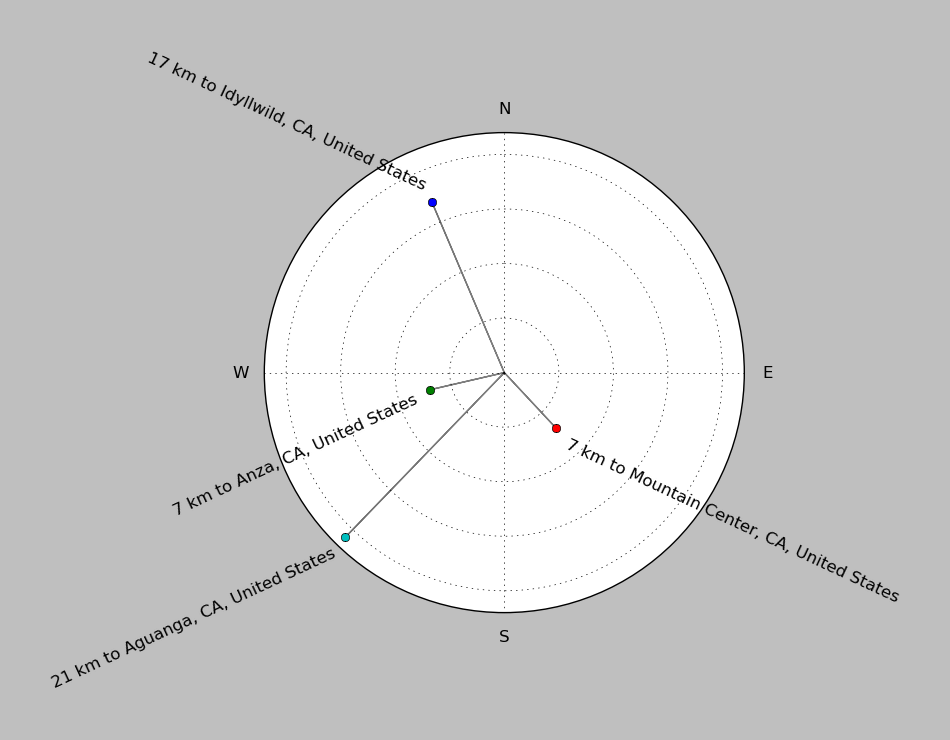
| ||||||||||||||||
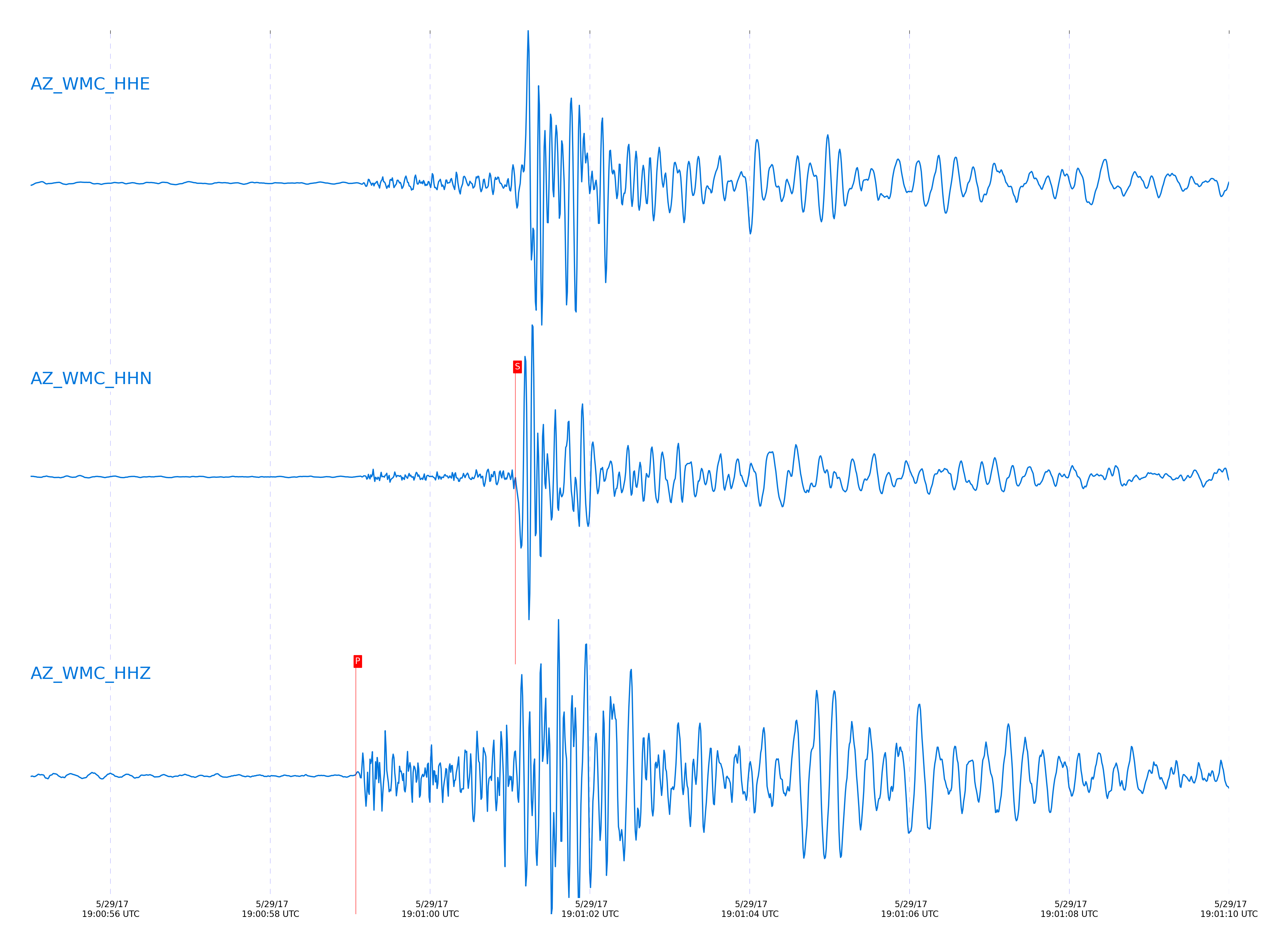
Event and active stations
|
|||||||||||||||||
Closest station with identified signal. Not filtered.
Subset of several stations close to the event. Not filtered.
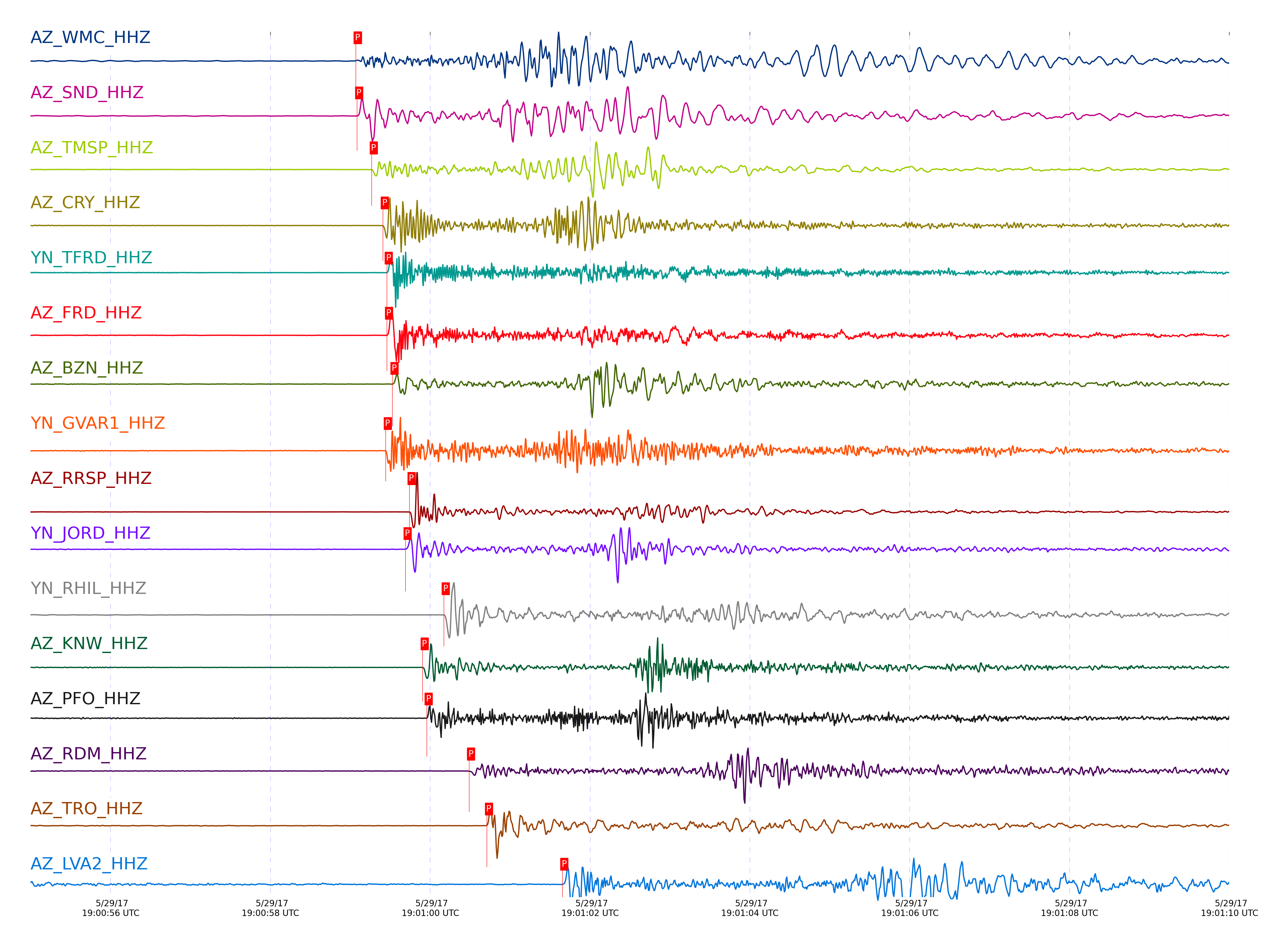
| STA_CHAN | S-E Delta | S-E Azimuth | Phase | Time | Signal/Noise | Time Residual | V. Model | Auth | arid |
|---|---|---|---|---|---|---|---|---|---|
| WMC_HHZ | 0.032° | 73.89° | Pg | 2017-05-29 19:00:59.069 UTC | -1 | 0.181 | iasp91 | dbp:jtytell:171 | 1408451 |
| WMC_HHN | 0.032° | 73.89° | Sg | 2017-05-29 19:01:01.0647 UTC | -1 | 0.269 | iasp91 | dbp:jtytell:171 | 1409152 |
| SND_HHZ | 0.037° | 325.98° | Pg | 2017-05-29 19:00:59.0857 UTC | -1 | 0.169 | iasp91 | dbp:jtytell:171 | 1408452 |
| SND_HHN | 0.037° | 325.98° | Sg | 2017-05-29 19:01:01.382 UTC | -1 | 0.53 | iasp91 | dbp:jtytell:171 | 1409153 |
| TMSP_HHZ | 0.051° | 135.55° | Pg | 2017-05-29 19:00:59.2689 UTC | -1 | 0.252 | iasp91 | dbp:jtytell:171 | 1408453 |
| CRY_HHZ | 0.085° | 78.33° | Pg | 2017-05-29 19:00:59.407 UTC | -1 | 0.083 | iasp91 | dbp:jtytell:171 | 1408458 |
| CRY_HHN | 0.085° | 78.33° | Sg | 2017-05-29 19:01:01.6004 UTC | -1 | -0.003 | iasp91 | dbp:jtytell:171 | 1409157 |
| TFRD_HHZ | 0.093° | 341.37° | Pg | 2017-05-29 19:00:59.457 UTC | -1 | 0.049 | iasp91 | dbp:jtytell:171 | 1409096 |
| TFRD_HHN | 0.093° | 341.37° | Sg | 2017-05-29 19:01:01.7328 UTC | -1 | -0.02 | iasp91 | dbp:jtytell:171 | 1409160 |
| FRD_HHZ | 0.093° | 341.39° | Pg | 2017-05-29 19:00:59.4593 UTC | -1 | 0.05 | iasp91 | dbp:jtytell:171 | 1409097 |
| FRD_HHN | 0.093° | 341.39° | Sg | 2017-05-29 19:01:01.768 UTC | -1 | 0.014 | iasp91 | dbp:jtytell:171 | 1409161 |
| BZN_HHZ | 0.094° | 15.01° | Pg | 2017-05-29 19:00:59.5278 UTC | -1 | 0.101 | iasp91 | dbp:jtytell:171 | 1409099 |
| BZN_HHN | 0.094° | 15.01° | Sg | 2017-05-29 19:01:01.8304 UTC | -1 | 0.046 | iasp91 | dbp:jtytell:171 | 1409162 |
| GVAR1_HHZ | 0.102° | 145.58° | Pg | 2017-05-29 19:00:59.4436 UTC | -1 | -0.066 | iasp91 | dbp:jtytell:171 | 1409106 |
| GVAR1_HHN | 0.102° | 145.58° | sPg | 2017-05-29 19:01:01.7473 UTC | -1 | 0.013 | iasp91 | dbp:jtytell:171 | 1409164 |
| RRSP_HHZ | 0.109° | 129.14° | Pg | 2017-05-29 19:00:59.7414 UTC | -1 | 0.141 | iasp91 | dbp:jtytell:171 | 1409100 |
| RRSP_HHN | 0.109° | 129.14° | Sg | 2017-05-29 19:01:02.3706 UTC | -1 | 0.282 | iasp91 | dbp:jtytell:171 | 1409166 |
| JORD_HHZ | 0.11° | 3.16° | Pg | 2017-05-29 19:00:59.6918 UTC | -1 | 0.076 | iasp91 | dbp:jtytell:171 | 1409102 |
| JORD_HHN | 0.11° | 3.16° | Sg | 2017-05-29 19:01:02.1526 UTC | -1 | 0.038 | iasp91 | dbp:jtytell:171 | 1409167 |
| RHIL_HHZ | 0.144° | 129.15° | Pg | 2017-05-29 19:01:00.1705 UTC | -1 | 0.125 | iasp91 | dbp:jtytell:171 | 1409108 |
| RHIL_HHE | 0.144° | 129.15° | Sg | 2017-05-29 19:01:03.2569 UTC | -1 | 0.407 | iasp91 | dbp:jtytell:171 | 1409172 |
| KNW_HHZ | 0.145° | 154.84° | Pg | 2017-05-29 19:00:59.906 UTC | -1 | -0.165 | iasp91 | dbp:jtytell:171 | 1409110 |
| KNW_HHN | 0.145° | 154.84° | sPg | 2017-05-29 19:01:02.5111 UTC | -1 | -0.063 | iasp91 | dbp:jtytell:171 | 1409171 |
| PFO_HHZ | 0.151° | 258.93° | Pg | 2017-05-29 19:00:59.9561 UTC | -1 | -0.199 | iasp91 | dbp:jtytell:171 | 1409114 |
| PFO_HHE | 0.151° | 258.93° | sPg | 2017-05-29 19:01:02.5804 UTC | -1 | -0.109 | iasp91 | dbp:jtytell:171 | 1409175 |
| RDM_HHZ | 0.181° | 105.13° | Pg | 2017-05-29 19:01:00.4864 UTC | -1 | -0.109 | iasp91 | dbp:jtytell:171 | 1409120 |
| RDM_HHN | 0.181° | 105.13° | Sg | 2017-05-29 19:01:03.7481 UTC | -1 | -0.029 | iasp91 | dbp:jtytell:171 | 1409180 |
| TRO_HHZ | 0.186° | 288.55° | Pg | 2017-05-29 19:01:00.7093 UTC | -1 | 0.037 | iasp91 | dbp:jtytell:171 | 1409118 |
| LVA2_HHZ | 0.239° | 344.63° | Pg | 2017-05-29 19:01:01.653 UTC | -1 | 0.119 | iasp91 | dbp:jtytell:171 | 1409125 |
| LVA2_HHN | 0.239° | 344.63° | Sg | 2017-05-29 19:01:05.4583 UTC | -1 | 0.116 | iasp91 | dbp:jtytell:171 | 1409183 |
| TR02_HHZ | 0.247° | 311.77° | Pg | 2017-05-29 19:01:01.6928 UTC | -1 | 0.036 | iasp91 | dbp:jtytell:171 | 1409127 |
| TR03_HHZ | 0.249° | 314.12° | Pg | 2017-05-29 19:01:01.7158 UTC | -1 | 0.024 | iasp91 | dbp:jtytell:171 | 1409128 |
| TR04_HHZ | 0.255° | 316.19° | Pg | 2017-05-29 19:01:01.9085 UTC | -1 | 0.114 | iasp91 | dbp:jtytell:171 | 1409126 |
| TR04_HHE | 0.255° | 316.19° | Sg | 2017-05-29 19:01:06.2014 UTC | -1 | 0.426 | iasp91 | dbp:jtytell:171 | 1409184 |
| SMER_HHZ | 0.462° | 74.17° | Pg | 2017-05-29 19:01:05.0119 UTC | -1 | -0.493 | iasp91 | dbp:jtytell:171 | 1409139 |
| SMER_HHN | 0.462° | 74.17° | Sg | 2017-05-29 19:01:11.4346 UTC | -1 | -0.734 | iasp91 | dbp:jtytell:171 | 1409195 |
| MONP2_HHE | 0.714° | 345.44° | Sg | 2017-05-29 19:01:19.1388 UTC | -1 | -1.201 | iasp91 | dbp:jtytell:171 | 1409204 |
| CPE_HHN | 0.796° | 29.28° | Sg | 2017-05-29 19:01:20.7904 UTC | -1 | -2.241 | iasp91 | dbp:jtytell:171 | 1409207 |
Click the link below to observe an interactive map of earthquakes recorded by the station deployment:
Broadband Seismic Data Collection Center (ANZA),
Institute of Geophysics & Planetary Physics
Scripps Institution of Oceanography,
University of California San Diego
Copyright © 1989 - 2014. All Rights Reserved.