
last update to page: June 14 2017 16:37:30 (UTC).
SummaryThe red marker denotes the earthquake epicenter. On Wed Jun 14th 2017 07:29:05 (UTC) the seismic network recorded an earthquake (preliminary 6.9 mww) located in Guatemala. Seismic region Mexico - Guatemala Area. The epicentral distance (i.e. distance separating the location to the epicenter) to the closest station USGCB in the network is 3,153.8 km. If you felt the quake, the USGS would like to know. Please add your comments to the USGS page "Did you feel it?". |
Details
Proximity to Population Centers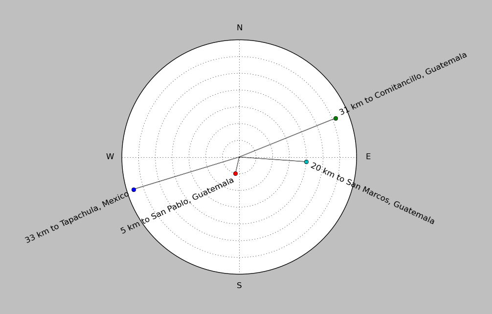
| ||||||||||||||||
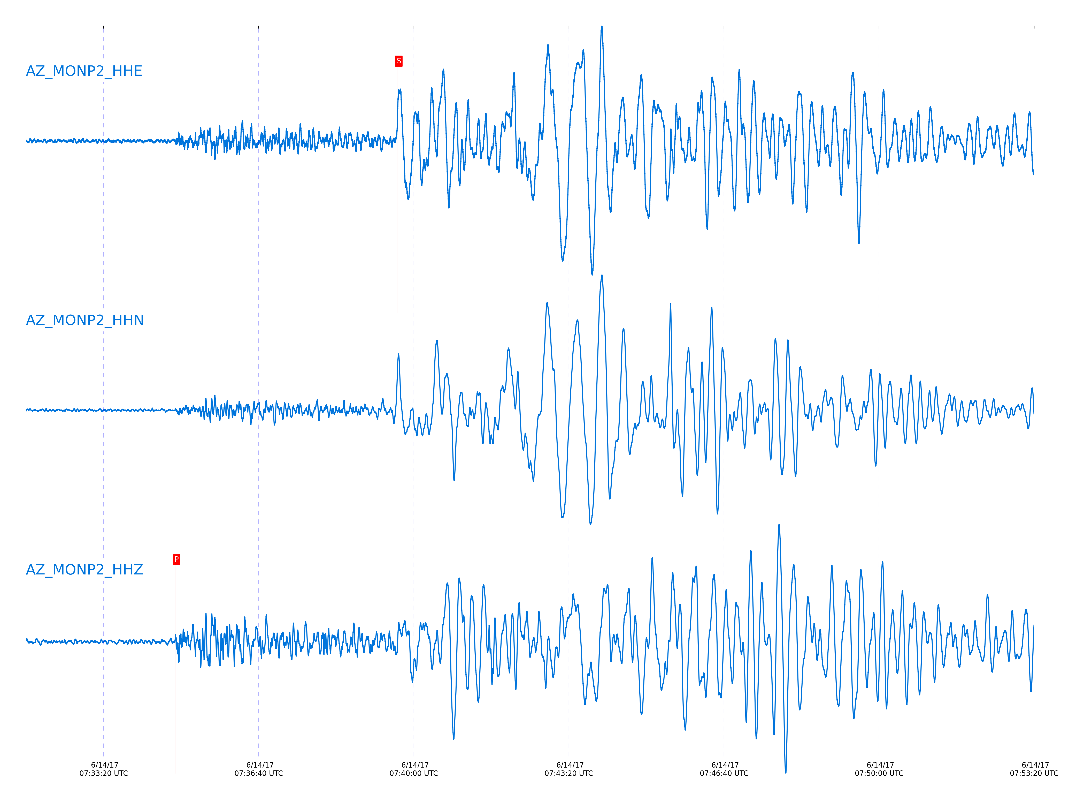
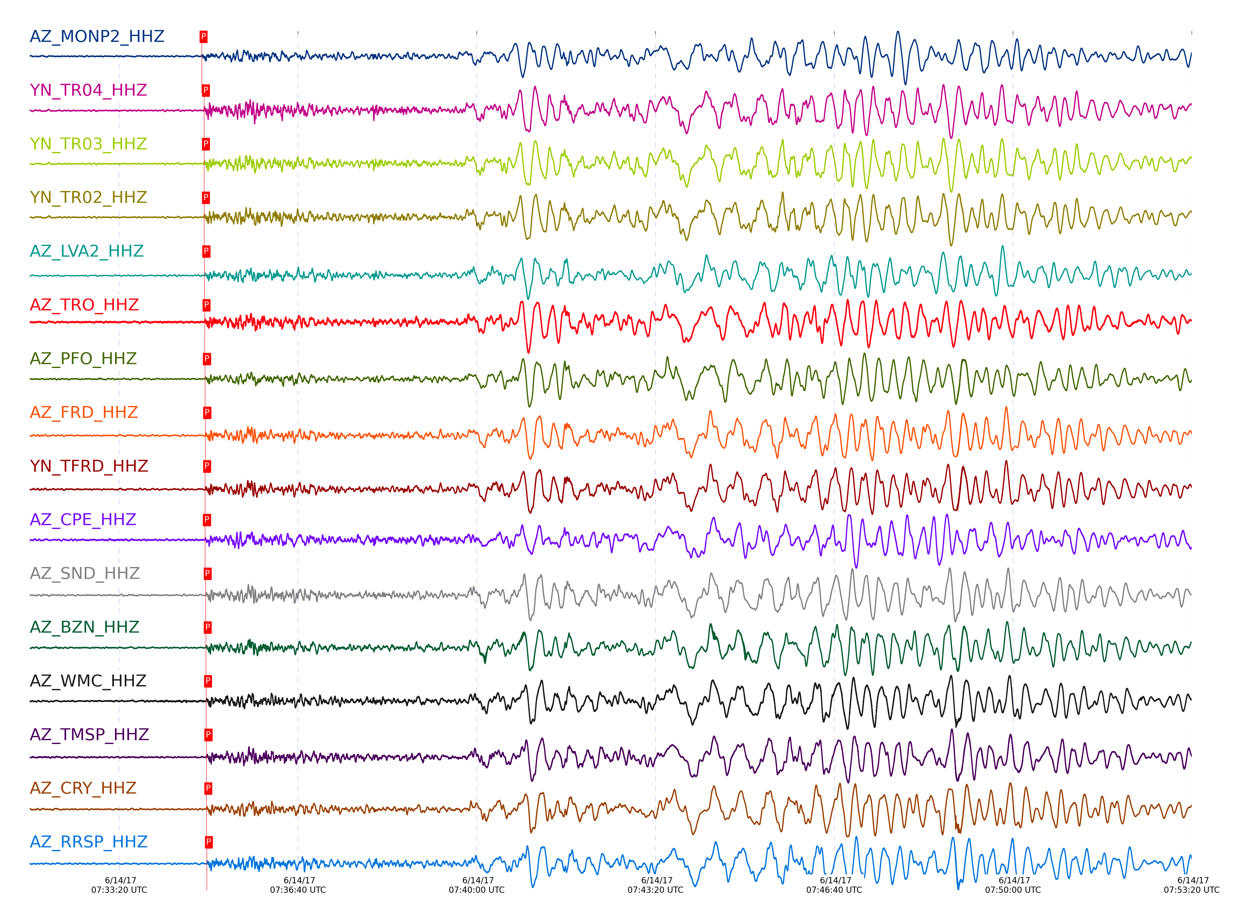
Event and active stations
|
|||||||||||||||||
Closest station with identified signal. Not filtered.
Subset of several stations close to the event. Not filtered.
| STA_CHAN | S-E Delta | S-E Azimuth | Phase | Time | Signal/Noise | Time Residual | V. Model | Auth | arid |
|---|---|---|---|---|---|---|---|---|---|
| MONP2_HHZ | 28.491° | 123.1° | P | 2017-06-14 07:34:52.2347 UTC | -1 | 0.322 | iasp91 | dbp:jtytell:171 | 1427448 |
| MONP2_HHE | 28.491° | 123.1° | S | 2017-06-14 07:39:38.4512 UTC | -1 | 4.986 | iasp91 | dbp:jtytell:171 | 1427500 |
| TR04_HHZ | 28.773° | 123.87° | P | 2017-06-14 07:34:54.954 UTC | -1 | 0.536 | iasp91 | dbp:jtytell:171 | 1427468 |
| TR04_HHN | 28.773° | 123.87° | S | 2017-06-14 07:39:42.3848 UTC | -1 | 4.49 | iasp91 | dbp:jtytell:171 | 1427507 |
| TR03_HHZ | 28.777° | 123.89° | P | 2017-06-14 07:34:54.9409 UTC | -1 | 0.487 | iasp91 | dbp:jtytell:171 | 1427470 |
| TR03_HHN | 28.777° | 123.89° | S | 2017-06-14 07:39:43.2377 UTC | -1 | 5.278 | iasp91 | dbp:jtytell:171 | 1427509 |
| TR02_HHZ | 28.778° | 123.92° | P | 2017-06-14 07:34:54.8909 UTC | -1 | 0.433 | iasp91 | dbp:jtytell:171 | 1427472 |
| TR02_HHN | 28.778° | 123.92° | S | 2017-06-14 07:39:43.0372 UTC | -1 | 5.071 | iasp91 | dbp:jtytell:171 | 1427510 |
| TR01_HHN | 28.778° | 123.93° | S | 2017-06-14 07:39:43.0397 UTC | -1 | 5.069 | iasp91 | dbp:jtytell:171 | 1427511 |
| LVA2_HHZ | 28.841° | 123.61° | P | 2017-06-14 07:34:55.3256 UTC | -1 | 0.306 | iasp91 | dbp:jtytell:171 | 1427451 |
| LVA2_HHE | 28.841° | 123.61° | S | 2017-06-14 07:39:44.6199 UTC | -1 | 5.66 | iasp91 | dbp:jtytell:171 | 1427513 |
| TRO_HHZ | 28.842° | 124.06° | P | 2017-06-14 07:34:55.5787 UTC | -1 | 0.546 | iasp91 | dbp:jtytell:171 | 1427477 |
| TRO_HHE | 28.842° | 124.06° | S | 2017-06-14 07:39:44.8377 UTC | -1 | 5.854 | iasp91 | dbp:jtytell:171 | 1427514 |
| PFO_HHZ | 28.915° | 124.15° | P | 2017-06-14 07:34:55.9739 UTC | -1 | 0.296 | iasp91 | dbp:jtytell:171 | 1427481 |
| PFO_HHE | 28.915° | 124.15° | S | 2017-06-14 07:39:45.6868 UTC | -1 | 5.561 | iasp91 | dbp:jtytell:171 | 1427522 |
| FRD_HHZ | 28.949° | 123.77° | P | 2017-06-14 07:34:56.3351 UTC | -1 | 0.362 | iasp91 | dbp:jtytell:171 | 1427456 |
| FRD_HHE | 28.949° | 123.77° | S | 2017-06-14 07:39:45.3699 UTC | -1 | 4.721 | iasp91 | dbp:jtytell:171 | 1427525 |
| TFRD_HHZ | 28.949° | 123.77° | P | 2017-06-14 07:34:56.1323 UTC | -1 | 0.158 | iasp91 | dbp:jtytell:171 | 1427457 |
| TFRD_HHE | 28.949° | 123.77° | S | 2017-06-14 07:39:45.7787 UTC | -1 | 5.129 | iasp91 | dbp:jtytell:171 | 1427526 |
| JORD_HHE | 28.966° | 123.68° | S | 2017-06-14 07:39:46.7473 UTC | -1 | 5.829 | iasp91 | dbp:jtytell:171 | 1427527 |
| CPE_HHZ | 28.972° | 122.17° | P | 2017-06-14 07:34:55.9812 UTC | -1 | -0.2 | iasp91 | dbp:jtytell:171 | 1427434 |
| CPE_HHN | 28.972° | 122.17° | S | 2017-06-14 07:39:44.3524 UTC | -1 | 3.337 | iasp91 | dbp:jtytell:171 | 1427529 |
| SND_HHZ | 28.988° | 123.84° | P | 2017-06-14 07:34:56.8469 UTC | -1 | 0.526 | iasp91 | dbp:jtytell:171 | 1427464 |
| SND_HHN | 28.988° | 123.84° | S | 2017-06-14 07:39:46.3301 UTC | -1 | 5.066 | iasp91 | dbp:jtytell:171 | 1427530 |
| BZN_HHZ | 28.992° | 123.68° | P | 2017-06-14 07:34:56.8618 UTC | -1 | 0.506 | iasp91 | dbp:jtytell:171 | 1427453 |
| BZN_HHE | 28.992° | 123.68° | S | 2017-06-14 07:39:46.569 UTC | -1 | 5.243 | iasp91 | dbp:jtytell:171 | 1427531 |
| WMC_HHZ | 29.043° | 123.79° | P | 2017-06-14 07:34:57.1867 UTC | -1 | 0.379 | iasp91 | dbp:jtytell:171 | 1427460 |
| WMC_HHE | 29.043° | 123.79° | S | 2017-06-14 07:39:47.2244 UTC | -1 | 5.1 | iasp91 | dbp:jtytell:171 | 1427533 |
| TMSP_HHZ | 29.072° | 123.85° | P | 2017-06-14 07:34:57.6376 UTC | -1 | 0.567 | iasp91 | dbp:jtytell:171 | 1427466 |
| TMSP_HHN | 29.072° | 123.85° | S | 2017-06-14 07:39:47.8956 UTC | -1 | 5.306 | iasp91 | dbp:jtytell:171 | 1427536 |
| CRY_HHZ | 29.081° | 123.69° | P | 2017-06-14 07:34:57.5836 UTC | -1 | 0.432 | iasp91 | dbp:jtytell:171 | 1427454 |
| CRY_HHE | 29.081° | 123.69° | S | 2017-06-14 07:39:47.7724 UTC | -1 | 5.039 | iasp91 | dbp:jtytell:171 | 1427537 |
| GVAR1_HHE | 29.116° | 123.88° | S | 2017-06-14 07:39:48.8978 UTC | -1 | 5.618 | iasp91 | dbp:jtytell:171 | 1427539 |
| RRSP_HHZ | 29.131° | 123.82° | P | 2017-06-14 07:34:58.0384 UTC | -1 | 0.451 | iasp91 | dbp:jtytell:171 | 1427462 |
| RRSP_HHE | 29.131° | 123.82° | S | 2017-06-14 07:39:49.4339 UTC | -1 | 5.928 | iasp91 | dbp:jtytell:171 | 1427540 |
| KNW_HHZ | 29.147° | 123.95° | P | 2017-06-14 07:34:57.9982 UTC | -1 | 0.27 | iasp91 | dbp:jtytell:171 | 1427474 |
| KNW_HHE | 29.147° | 123.95° | S | 2017-06-14 07:39:48.5539 UTC | -1 | 4.799 | iasp91 | dbp:jtytell:171 | 1427541 |
| RHIL_HHZ | 29.165° | 123.81° | P | 2017-06-14 07:34:58.3194 UTC | -1 | 0.429 | iasp91 | dbp:jtytell:171 | 1427461 |
| RHIL_HHE | 29.165° | 123.81° | S | 2017-06-14 07:39:49.7362 UTC | -1 | 5.695 | iasp91 | dbp:jtytell:171 | 1427542 |
| RDM_HHZ | 29.194° | 123.64° | P | 2017-06-14 07:34:58.4122 UTC | -1 | 0.266 | iasp91 | dbp:jtytell:171 | 1427452 |
| RDM_HHE | 29.194° | 123.64° | S | 2017-06-14 07:39:49.5844 UTC | -1 | 5.089 | iasp91 | dbp:jtytell:171 | 1427544 |
| SMER_HHZ | 29.324° | 122.94° | P | 2017-06-14 07:34:59.3956 UTC | -1 | 0.094 | iasp91 | dbp:jtytell:171 | 1427443 |
| SMER_HHE | 29.324° | 122.94° | S | 2017-06-14 07:39:50.7392 UTC | -1 | 4.199 | iasp91 | dbp:jtytell:171 | 1427549 |
Click the link below to observe an interactive map of earthquakes recorded by the station deployment:
Broadband Seismic Data Collection Center (ANZA),
Institute of Geophysics & Planetary Physics
Scripps Institution of Oceanography,
University of California San Diego
Copyright © 1989 - 2014. All Rights Reserved.