
last update to page: July 21 2017 16:53:24 (UTC).
SummaryThe red marker denotes the earthquake epicenter. On Thu Jul 20th 2017 22:31:12 (UTC) the seismic network recorded an earthquake (preliminary 6.7 mww) located in Dodecanese Islands, Greece. Seismic region Middle East - Crimea - Balkans. The epicentral distance (i.e. distance separating the location to the epicenter) to the closest station PSPR in the network is 11,336.0 km. If you felt the quake, the USGS would like to know. Please add your comments to the USGS page "Did you feel it?". |
Details
Proximity to Population Centers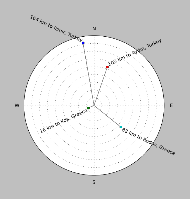
| ||||||||||||||||
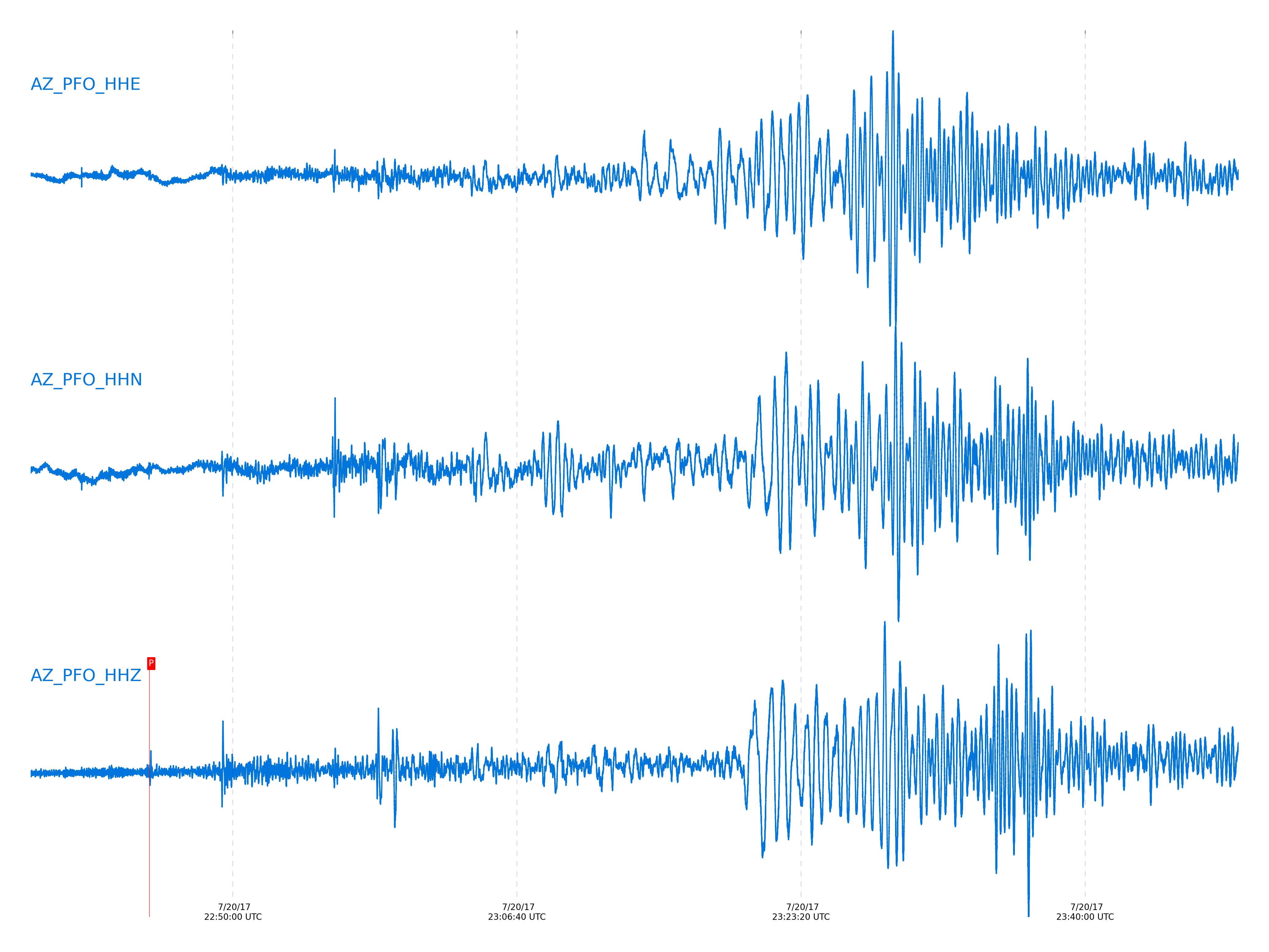
Event and active stations
|
|||||||||||||||||
Closest station with identified signal. Not filtered.
Subset of several stations close to the event. Not filtered.
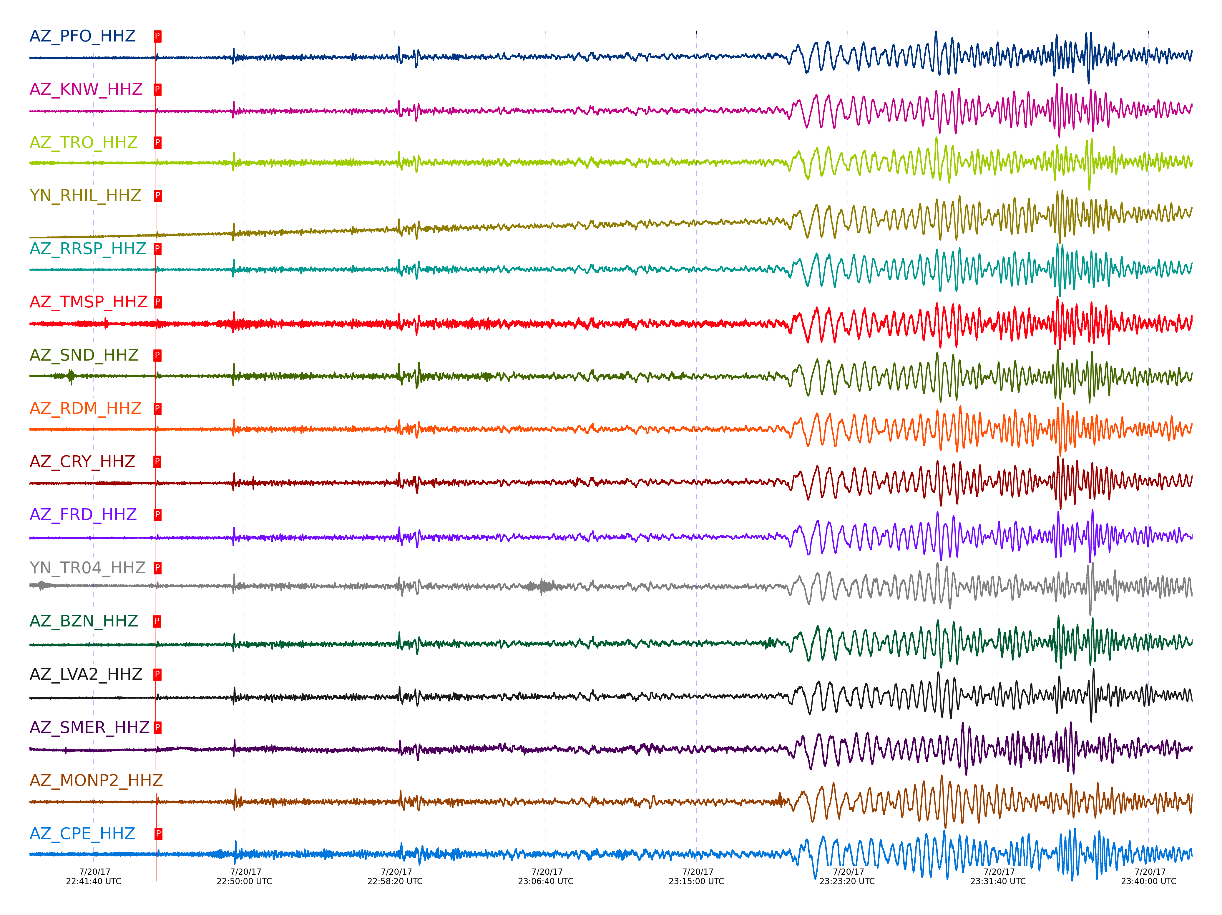
| STA_CHAN | S-E Delta | S-E Azimuth | Phase | Time | Signal/Noise | Time Residual | V. Model | Auth | arid |
|---|---|---|---|---|---|---|---|---|---|
| PFO_HHZ | 101.838° | 28.74° | Pdiff | 2017-07-20 22:45:06.2387 UTC | -1 | 0.943 | iasp91 | dbp:rrodd:17202 | 1458581 |
| KNW_HHZ | 101.849° | 28.56° | Pdiff | 2017-07-20 22:45:05.9629 UTC | -1 | 0.619 | iasp91 | dbp:rrodd:17202 | 1458585 |
| TRO_HHZ | 101.902° | 28.78° | Pdiff | 2017-07-20 22:45:06.3602 UTC | -1 | 0.781 | iasp91 | dbp:rrodd:17202 | 1458588 |
| RHIL_HHZ | 101.908° | 28.52° | pPdiff | 2017-07-20 22:45:07.6047 UTC | -1 | -1.358 | iasp91 | dbp:rrodd:17202 | 1458590 |
| RRSP_HHZ | 101.914° | 28.54° | Pdiff | 2017-07-20 22:45:06.0935 UTC | -1 | 0.457 | iasp91 | dbp:rrodd:17202 | 1458592 |
| TMSP_HHZ | 101.92° | 28.59° | Pdiff | 2017-07-20 22:45:07.2504 UTC | -1 | 1.591 | iasp91 | dbp:rrodd:17202 | 1458593 |
| SND_HHZ | 101.951° | 28.64° | Pdiff | 2017-07-20 22:45:05.7568 UTC | -1 | -0.044 | iasp91 | dbp:rrodd:17202 | 1458555 |
| WMC_HHZ | 101.957° | 28.6° | Pdiff | 2017-07-20 22:45:06.2828 UTC | -1 | 0.457 | iasp91 | dbp:rrodd:17202 | 1458596 |
| RDM_HHZ | 101.976° | 28.47° | Pdiff | 2017-07-20 22:45:06.1255 UTC | -1 | 0.214 | iasp91 | dbp:rrodd:17202 | 1458597 |
| CRY_HHZ | 101.989° | 28.55° | Pdiff | 2017-07-20 22:45:05.6614 UTC | -1 | -0.307 | iasp91 | dbp:rrodd:17202 | 1458554 |
| FRD_HHZ | 101.997° | 28.66° | Pdiff | 2017-07-20 22:45:06.5428 UTC | -1 | 0.538 | iasp91 | dbp:rrodd:17202 | 1458600 |
| TR04_HHZ | 102.011° | 28.79° | Pdiff | 2017-07-20 22:45:06.6024 UTC | -1 | 0.538 | iasp91 | dbp:rrodd:17202 | 1458602 |
| BZN_HHZ | 102.026° | 28.61° | Pdiff | 2017-07-20 22:45:04.8258 UTC | -1 | -1.307 | iasp91 | dbp:rrodd:17202 | 1458552 |
| JORD_HHZ | 102.034° | 28.63° | Pdiff | 2017-07-20 22:45:05.3778 UTC | -1 | -0.791 | iasp91 | dbp:rrodd:17202 | 1458553 |
| LVA2_HHZ | 102.107° | 28.7° | Pdiff | 2017-07-20 22:45:05.6677 UTC | -1 | -0.822 | iasp91 | dbp:rrodd:17202 | 1458551 |
| SMER_HHZ | 102.256° | 28.26° | Pdiff | 2017-07-20 22:45:06.637 UTC | -1 | -0.516 | iasp91 | dbp:rrodd:17202 | 1458606 |
| MONP2_HHZ | 102.453° | 28.85° | Pdiff | 2017-07-20 22:45:08.5669 UTC | -1 | 0.538 | iasp91 | dbp:rrodd:17202 | 1458558 |
| CPE_HHZ | 102.731° | 28.36° | Pdiff | 2017-07-20 22:45:09.3112 UTC | -1 | 0.052 | iasp91 | dbp:rrodd:17202 | 1458617 |
Click the link below to observe an interactive map of earthquakes recorded by the station deployment:
Broadband Seismic Data Collection Center (ANZA),
Institute of Geophysics & Planetary Physics
Scripps Institution of Oceanography,
University of California San Diego
Copyright © 1989 - 2014. All Rights Reserved.