
last update to page: September 03 2017 06:30:14 (UTC).
SummaryThe red marker denotes the earthquake epicenter. On Sun Sep 3rd 2017 03:30:01 (UTC) the seismic network recorded an earthquake (preliminary 6.3 mb) located in North Korea. Seismic region Eastern Asia. The epicentral distance (i.e. distance separating the location to the epicenter) to the closest station CSLB in the network is 9,219.8 km. If you felt the quake, the USGS would like to know. Please add your comments to the USGS page "Did you feel it?". |
Details
Proximity to Population Centers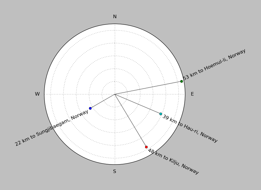
| ||||||||||||||||
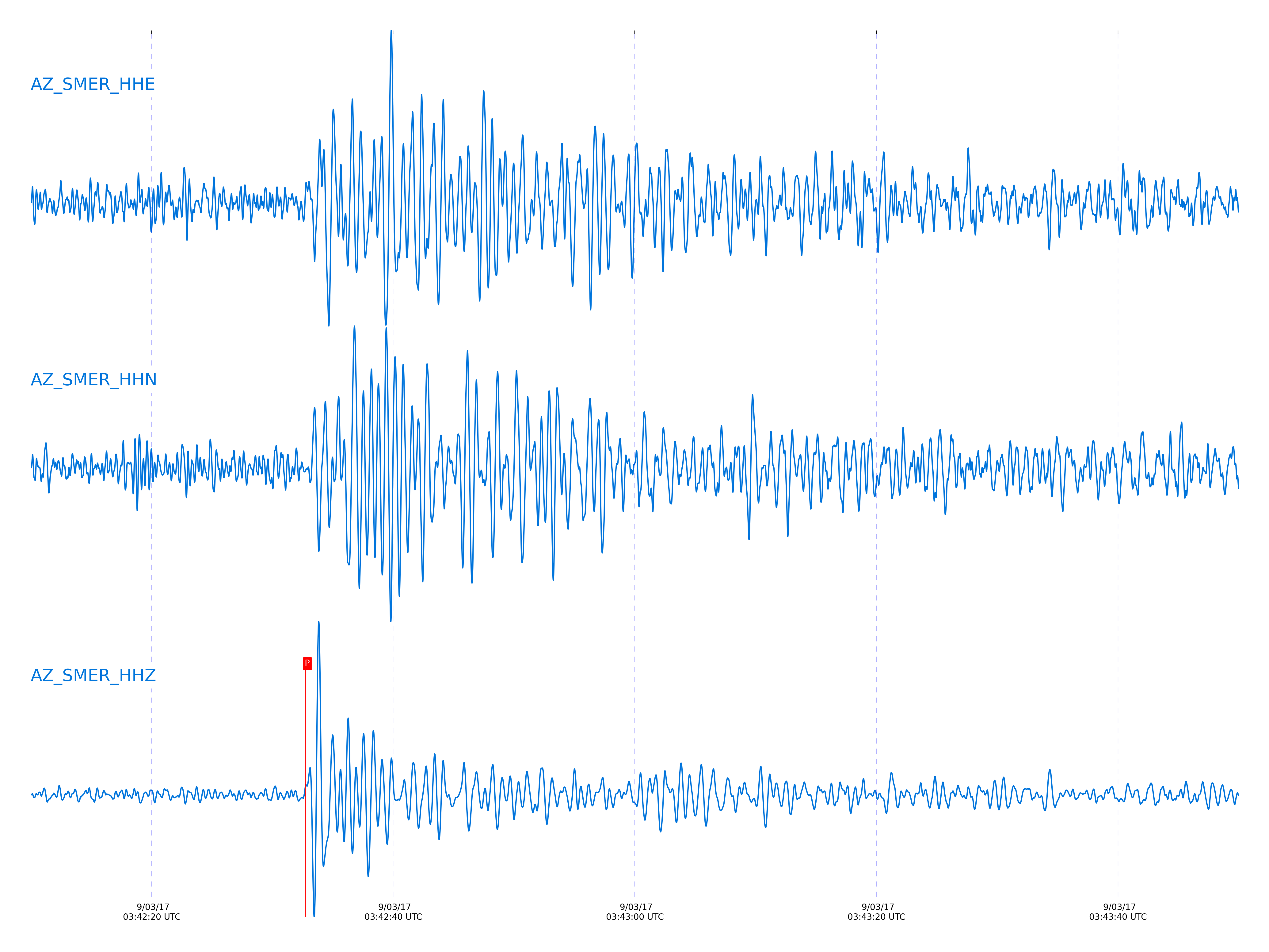
Event and active stations
|
|||||||||||||||||
Closest station with identified signal. 0.8 to 3 Hz bandpass Butterworth filter has been applied to data.
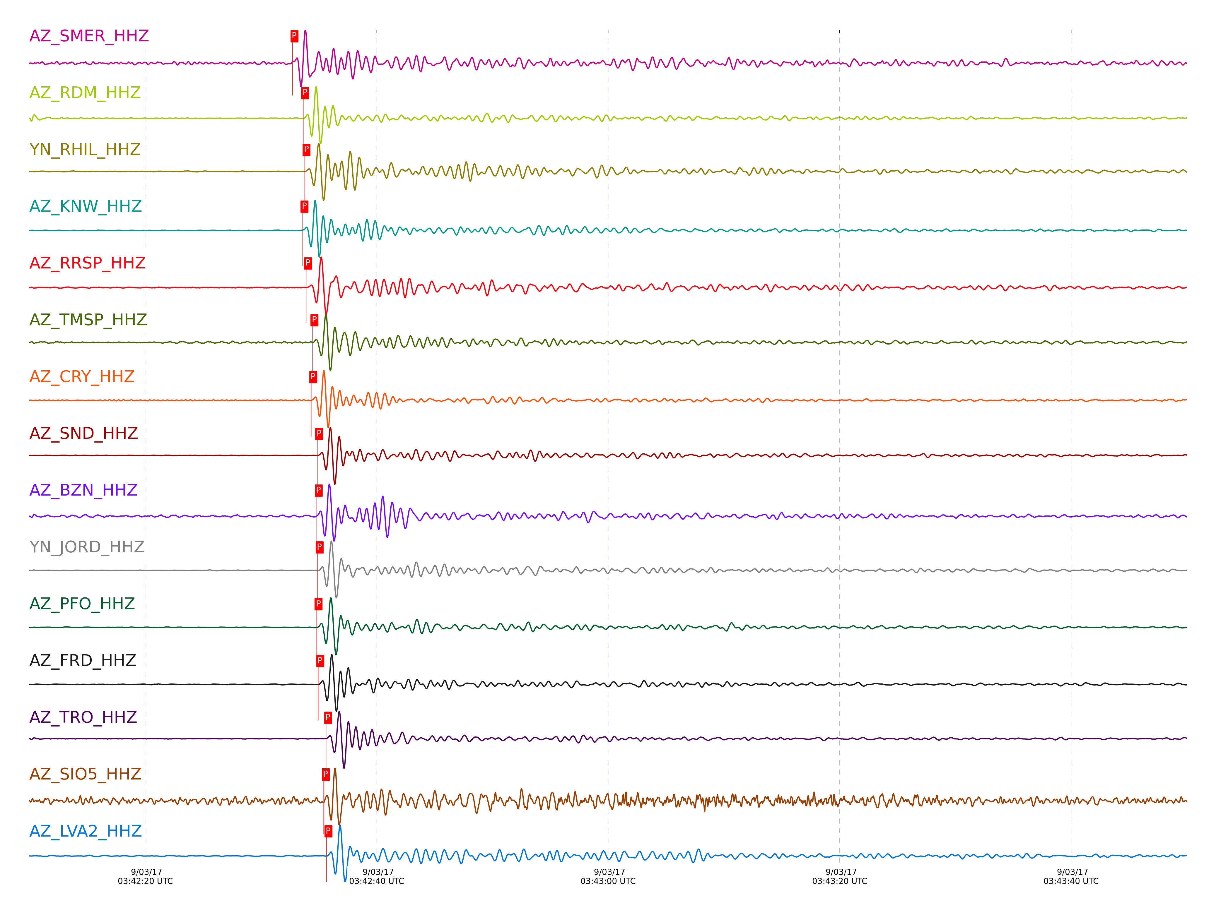
Subset of several stations close to the event. 0.8 to 3 Hz bandpass Butterworth filter has been applied to data.
| STA_CHAN | S-E Delta | S-E Azimuth | Phase | Time | Signal/Noise | Time Residual | V. Model | Auth | arid |
|---|---|---|---|---|---|---|---|---|---|
| SMER_HHZ | 83.599° | 316.27° | P | 2017-09-03 03:42:32.7345 UTC | -1 | 0.614 | iasp91 | dbp:jtytell:172 | 1501116 |
| RDM_HHZ | 83.66° | 316.41° | P | 2017-09-03 03:42:33.6494 UTC | -1 | 1.215 | iasp91 | dbp:jtytell:172 | 1501117 |
| RDM_HHZ | 83.66° | 316.41° | P | 2017-09-03 03:42:33.6494 UTC | -1 | 1.215 | iasp91 | dbp:jtytell:172 | 1501117 |
| RHIL_HHZ | 83.673° | 316.45° | P | 2017-09-03 03:42:33.774 UTC | -1 | 1.275 | iasp91 | dbp:jtytell:172 | 1501118 |
| KNW_HHZ | 83.677° | 316.47° | P | 2017-09-03 03:42:33.5961 UTC | -1 | 1.075 | iasp91 | dbp:jtytell:172 | 1501119 |
| RRSP_HHZ | 83.707° | 316.46° | P | 2017-09-03 03:42:33.908 UTC | -1 | 1.235 | iasp91 | dbp:jtytell:172 | 1501123 |
| TMSP_HHZ | 83.764° | 316.49° | P | 2017-09-03 03:42:34.46 UTC | -1 | 1.496 | iasp91 | dbp:jtytell:172 | 1501126 |
| CRY_HHZ | 83.77° | 316.47° | P | 2017-09-03 03:42:34.3537 UTC | -1 | 1.355 | iasp91 | dbp:jtytell:172 | 1501127 |
| SND_HHZ | 83.852° | 316.53° | P | 2017-09-03 03:42:34.8684 UTC | -1 | 1.456 | iasp91 | dbp:jtytell:172 | 1501131 |
| BZN_HHZ | 83.864° | 316.51° | P | 2017-09-03 03:42:34.8335 UTC | -1 | 1.355 | iasp91 | dbp:jtytell:172 | 1501133 |
| JORD_HHZ | 83.891° | 316.52° | P | 2017-09-03 03:42:34.9092 UTC | -1 | 1.295 | iasp91 | dbp:jtytell:172 | 1501135 |
| PFO_HHZ | 83.896° | 316.6° | P | 2017-09-03 03:42:34.8147 UTC | -1 | 1.175 | iasp91 | dbp:jtytell:172 | 1501137 |
| PFO_HHZ | 83.896° | 316.6° | P | 2017-09-03 03:42:34.8147 UTC | -1 | 1.175 | iasp91 | dbp:jtytell:172 | 1501137 |
| FRD_HHZ | 83.899° | 316.54° | P | 2017-09-03 03:42:34.9512 UTC | -1 | 1.295 | iasp91 | dbp:jtytell:172 | 1501140 |
| TRO_HHZ | 83.98° | 316.63° | P | 2017-09-03 03:42:35.6412 UTC | -1 | 1.576 | iasp91 | dbp:jtytell:172 | 1501148 |
| SIO5_HHZ | 83.999° | 316.28° | P | 2017-09-03 03:42:35.4406 UTC | -1 | 1.275 | iasp91 | dbp:jtytell:172 | 1501150 |
| SIO5_HHZ | 83.999° | 316.28° | P | 2017-09-03 03:42:35.4406 UTC | -1 | 1.275 | iasp91 | dbp:jtytell:172 | 1501150 |
| SIO5_HHZ | 83.999° | 316.28° | P | 2017-09-03 03:42:35.4406 UTC | -1 | 1.275 | iasp91 | dbp:jtytell:172 | 1501150 |
| LVA2_HHZ | 84.027° | 316.57° | P | 2017-09-03 03:42:35.6597 UTC | -1 | 1.355 | iasp91 | dbp:jtytell:172 | 1501151 |
| CPE_HHZ | 84.048° | 316.34° | P | 2017-09-03 03:42:35.2692 UTC | -1 | 0.854 | iasp91 | dbp:jtytell:172 | 1501152 |
| TR02_HHZ | 84.061° | 316.64° | P | 2017-09-03 03:42:35.7753 UTC | -1 | 1.295 | iasp91 | dbp:jtytell:172 | 1501154 |
| TR02_HHZ | 84.061° | 316.64° | P | 2017-09-03 03:42:35.7753 UTC | -1 | 1.295 | iasp91 | dbp:jtytell:172 | 1501154 |
| TR03_HHZ | 84.064° | 316.64° | P | 2017-09-03 03:42:35.8491 UTC | -1 | 1.355 | iasp91 | dbp:jtytell:172 | 1501156 |
| TR03_HHZ | 84.064° | 316.64° | P | 2017-09-03 03:42:35.8491 UTC | -1 | 1.355 | iasp91 | dbp:jtytell:172 | 1501156 |
| MONP2_HHZ | 84.441° | 316.67° | P | 2017-09-03 03:42:37.7004 UTC | -1 | 1.295 | iasp91 | dbp:jtytell:172 | 1501164 |
Click the link below to observe an interactive map of earthquakes recorded by the station deployment:
Broadband Seismic Data Collection Center (ANZA),
Institute of Geophysics & Planetary Physics
Scripps Institution of Oceanography,
University of California San Diego
Copyright © 1989 - 2014. All Rights Reserved.