
last update to page: October 27 2017 19:28:17 (UTC).
SummaryThe red marker denotes the earthquake epicenter. On Thu Oct 26th 2017 23:18:28 (UTC) the seismic network recorded an earthquake (preliminary 3.71 ml) located in Southern California. Seismic region California - Nevada Region. The epicentral distance (i.e. distance separating the location to the epicenter) to the closest station CSLB in the network is 36.0 km. If you felt the quake, the USGS would like to know. Please add your comments to the USGS page "Did you feel it?". |
Details
Proximity to Population Centers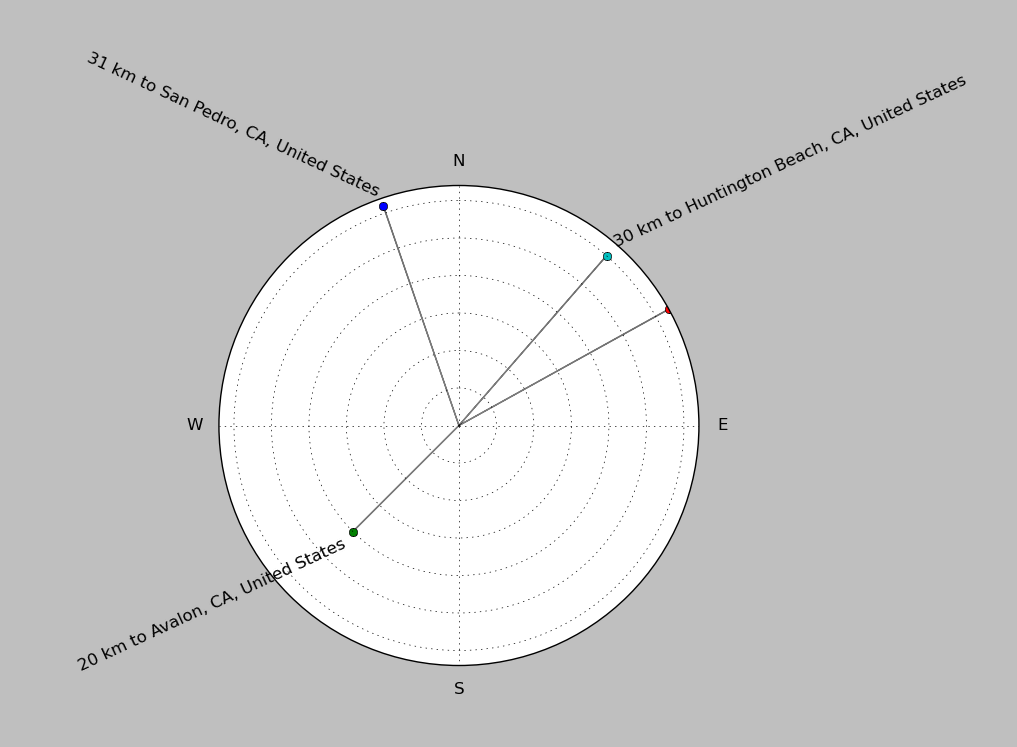
| ||||||||||||||||
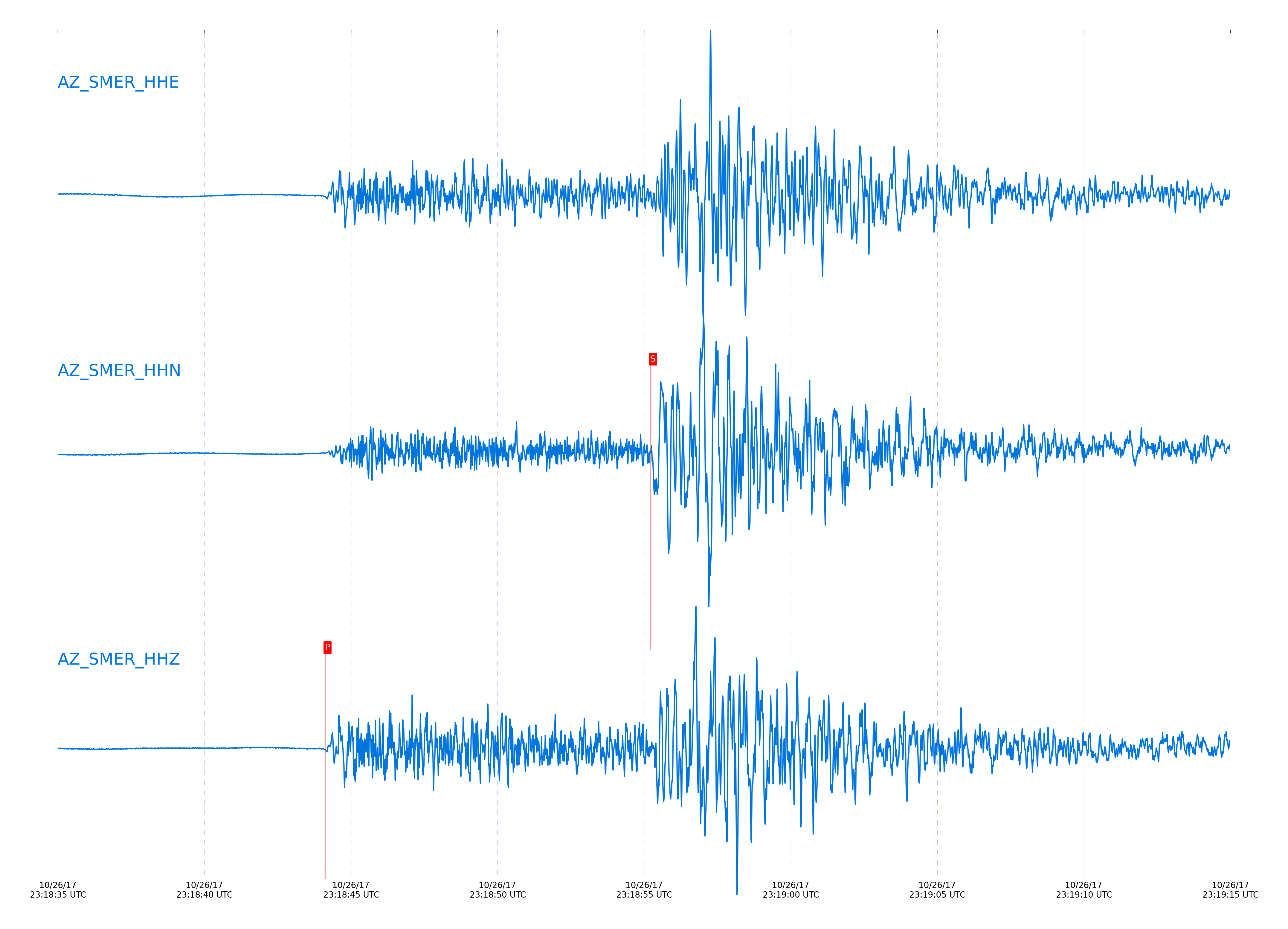
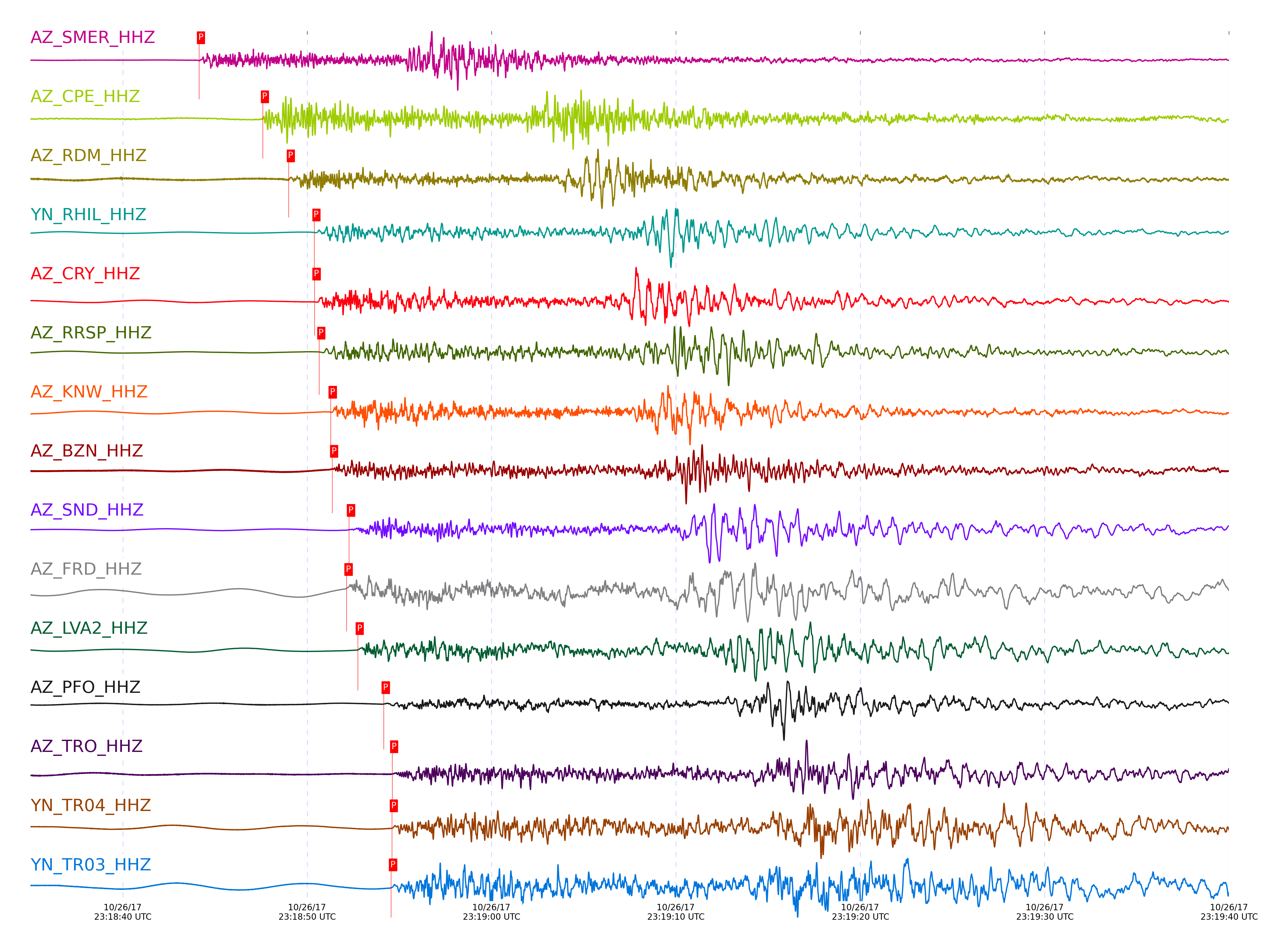
Event and active stations
|
|||||||||||||||||
Closest station with identified signal. Not filtered.
Subset of several stations close to the event. Not filtered.
| STA_CHAN | S-E Delta | S-E Azimuth | Phase | Time | Signal/Noise | Time Residual | V. Model | Auth | arid |
|---|---|---|---|---|---|---|---|---|---|
| SMER_HHZ | 0.845° | 270.56° | Pg | 2017-10-26 23:18:44.1315 UTC | 77.616 | -0.838 | iasp91 | dbp:jtytell:173 | 1565533 |
| SMER_HHN | 0.845° | 270.56° | Sg | 2017-10-26 23:18:55.2229 UTC | -1 | -1.587 | iasp91 | dbp:jtytell:173 | 1566561 |
| SIO5_HHN | 0.999° | 308.71° | Sg | 2017-10-26 23:19:01.4699 UTC | -1 | -0.383 | iasp91 | dbp:jtytell:173 | 1566568 |
| CPE_HHZ | 1.069° | 302.69° | Pb | 2017-10-26 23:18:47.5938 UTC | 52.128 | -1.602 | iasp91 | dbp:jtytell:173 | 1565535 |
| CPE_HHN | 1.069° | 302.69° | Sb | 2017-10-26 23:19:02.8956 UTC | -1 | -1.272 | iasp91 | dbp:jtytell:173 | 1566571 |
| RDM_HHZ | 1.126° | 261.78° | Pb | 2017-10-26 23:18:49.0036 UTC | 48.897 | -1.161 | iasp91 | dbp:jtytell:173 | 1565565 |
| RDM_HHN | 1.126° | 261.78° | Sb | 2017-10-26 23:19:03.5324 UTC | -1 | -2.314 | iasp91 | dbp:jtytell:173 | 1566574 |
| RHIL_HHZ | 1.196° | 260.21° | Pn | 2017-10-26 23:18:50.3859 UTC | -1 | -0.965 | iasp91 | dbp:jtytell:173 | 1566522 |
| RHIL_HHN | 1.196° | 260.21° | Sb | 2017-10-26 23:19:06.5352 UTC | -1 | -1.371 | iasp91 | dbp:jtytell:173 | 1566578 |
| CRY_HHZ | 1.21° | 265.49° | Pn | 2017-10-26 23:18:50.3982 UTC | 150.58 | -1.154 | iasp91 | dbp:jtytell:173 | 1565539 |
| CRY_HHN | 1.21° | 265.49° | Sb | 2017-10-26 23:19:06.3704 UTC | -1 | -1.969 | iasp91 | dbp:jtytell:173 | 1566579 |
| RRSP_HHZ | 1.218° | 261.44° | Pn | 2017-10-26 23:18:50.6522 UTC | -1 | -1.011 | iasp91 | dbp:jtytell:173 | 1566525 |
| RRSP_HHN | 1.218° | 261.44° | Sb | 2017-10-26 23:19:07.0229 UTC | -1 | -1.555 | iasp91 | dbp:jtytell:173 | 1566582 |
| KNW_HHZ | 1.252° | 258.78° | Pn | 2017-10-26 23:18:51.2751 UTC | 143.63 | -0.846 | iasp91 | dbp:jtytell:173 | 1565541 |
| KNW_HHE | 1.252° | 258.78° | Sb | 2017-10-26 23:19:07.708 UTC | -1 | -1.855 | iasp91 | dbp:jtytell:173 | 1566587 |
| TMSP_HHN | 1.262° | 263.25° | Sb | 2017-10-26 23:19:08.6758 UTC | -1 | -1.202 | iasp91 | dbp:jtytell:173 | 1566590 |
| BZN_HHZ | 1.265° | 269.07° | Pn | 2017-10-26 23:18:51.3533 UTC | 50.853 | -0.956 | iasp91 | dbp:jtytell:173 | 1565568 |
| BZN_HHN | 1.265° | 269.07° | Sb | 2017-10-26 23:19:08.2282 UTC | -1 | -1.739 | iasp91 | dbp:jtytell:173 | 1566588 |
| SND_HHZ | 1.313° | 266.5° | Pn | 2017-10-26 23:18:52.2684 UTC | 274.54 | -0.693 | iasp91 | dbp:jtytell:173 | 1565553 |
| SND_HHN | 1.313° | 266.5° | Sn | 2017-10-26 23:19:10.1031 UTC | -1 | -1.19 | iasp91 | dbp:jtytell:173 | 1566596 |
| FRD_HHZ | 1.32° | 269.01° | Pn | 2017-10-26 23:18:52.1335 UTC | 136.3 | -0.92 | iasp91 | dbp:jtytell:173 | 1565549 |
| FRD_HHN | 1.32° | 269.01° | Sn | 2017-10-26 23:19:09.7407 UTC | -1 | -1.717 | iasp91 | dbp:jtytell:173 | 1566598 |
| LVA2_HHZ | 1.359° | 275.1° | Pn | 2017-10-26 23:18:52.7434 UTC | 127.91 | -0.848 | iasp91 | dbp:jtytell:173 | 1565555 |
| LVA2_HHE | 1.359° | 275.1° | Sn | 2017-10-26 23:19:11.4318 UTC | -1 | -0.994 | iasp91 | dbp:jtytell:173 | 1566601 |
| PFO_HHZ | 1.445° | 264.52° | Pn | 2017-10-26 23:18:54.1504 UTC | -1 | -0.63 | iasp91 | dbp:jtytell:173 | 1566539 |
| PFO_HHN | 1.445° | 264.52° | Sn | 2017-10-26 23:19:13.3362 UTC | -1 | -1.227 | iasp91 | dbp:jtytell:173 | 1566610 |
| TRO_HHZ | 1.467° | 268.08° | Pn | 2017-10-26 23:18:54.608 UTC | 25.075 | -0.479 | iasp91 | dbp:jtytell:173 | 1565561 |
| TRO_HHN | 1.467° | 268.08° | Sn | 2017-10-26 23:19:14.7614 UTC | -1 | -0.354 | iasp91 | dbp:jtytell:173 | 1566615 |
| TR04_HHZ | 1.468° | 272.94° | Pn | 2017-10-26 23:18:54.5926 UTC | -1 | -0.506 | iasp91 | dbp:jtytell:173 | 1566542 |
| TR03_HHZ | 1.47° | 272.52° | Pn | 2017-10-26 23:18:54.5481 UTC | -1 | -0.575 | iasp91 | dbp:jtytell:173 | 1566543 |
| TR02_HHZ | 1.475° | 272.18° | Pn | 2017-10-26 23:18:54.7476 UTC | -1 | -0.445 | iasp91 | dbp:jtytell:173 | 1566544 |
| TR02_HHN | 1.475° | 272.18° | Sb | 2017-10-26 23:19:15.7577 UTC | -1 | -0.405 | iasp91 | dbp:jtytell:173 | 1566616 |
| MONP2_HHZ | 1.581° | 291.61° | Pn | 2017-10-26 23:18:55.494 UTC | 19.858 | -1.149 | iasp91 | dbp:jtytell:173 | 1565570 |
| MONP2_HHE | 1.581° | 291.61° | Sn | 2017-10-26 23:19:17.0163 UTC | -1 | -0.898 | iasp91 | dbp:jtytell:173 | 1566622 |
Click the link below to observe an interactive map of earthquakes recorded by the station deployment:
Broadband Seismic Data Collection Center (ANZA),
Institute of Geophysics & Planetary Physics
Scripps Institution of Oceanography,
University of California San Diego
Copyright © 1989 - 2014. All Rights Reserved.