
last update to page: December 07 2017 01:06:14 (UTC).
SummaryThe red marker denotes the earthquake epicenter. On Thu Dec 7th 2017 00:33:15 (UTC) the seismic network recorded an earthquake (preliminary 4.16 mlr) located in Southern California. Seismic region California - Nevada Region. The epicentral distance (i.e. distance separating the location to the epicenter) to the closest station TUBB in the network is 9.7 km. If you felt the quake, the USGS would like to know. Please add your comments to the USGS page "Did you feel it?". |
Details
Proximity to Population Centers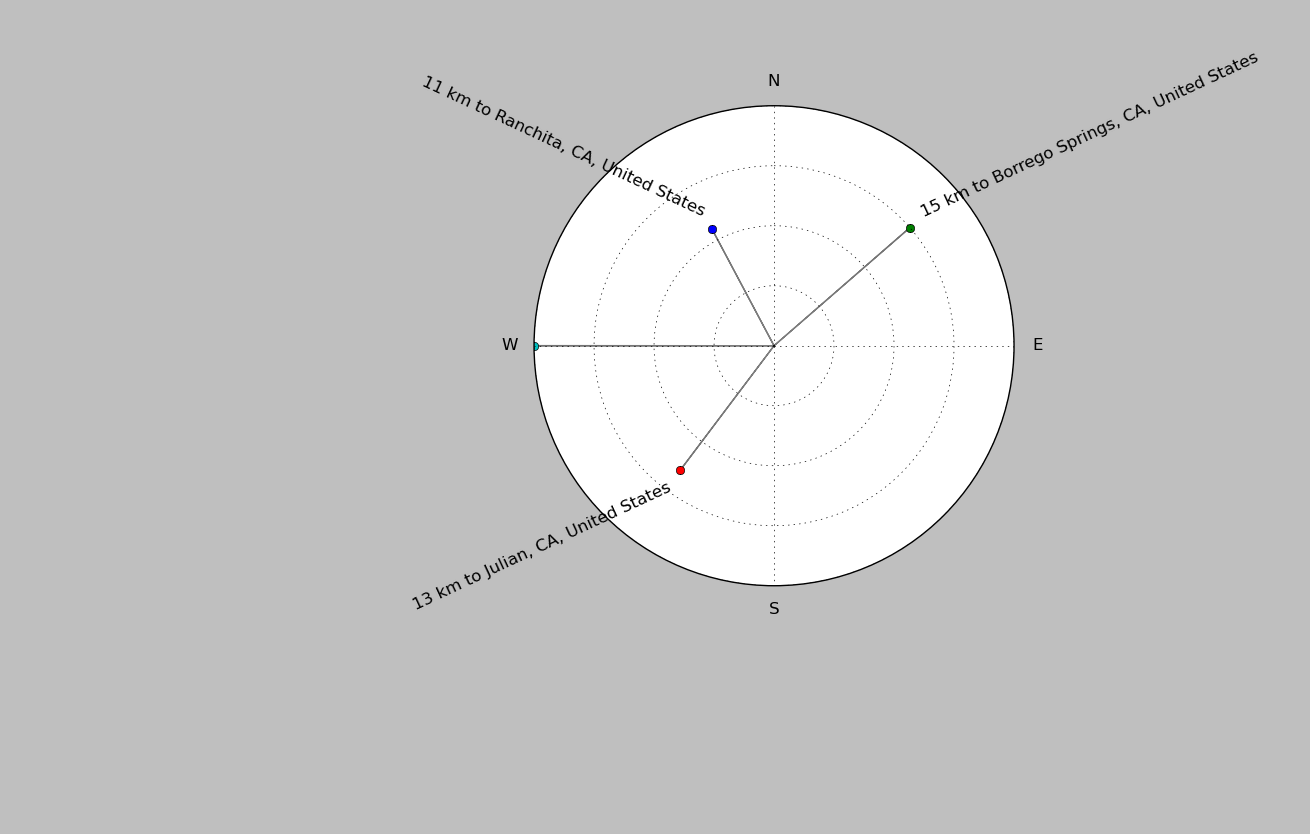
| ||||||||||||||||
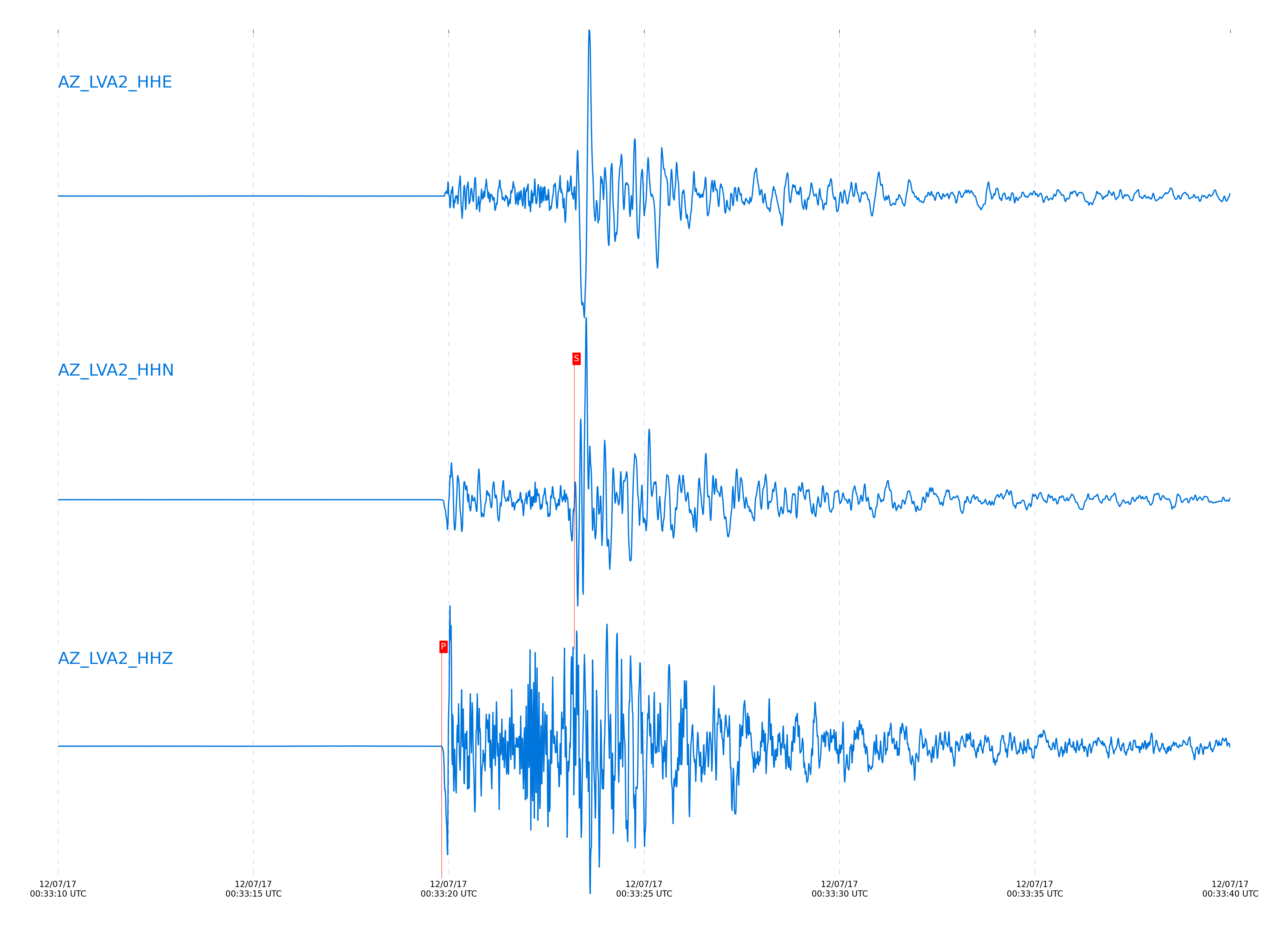
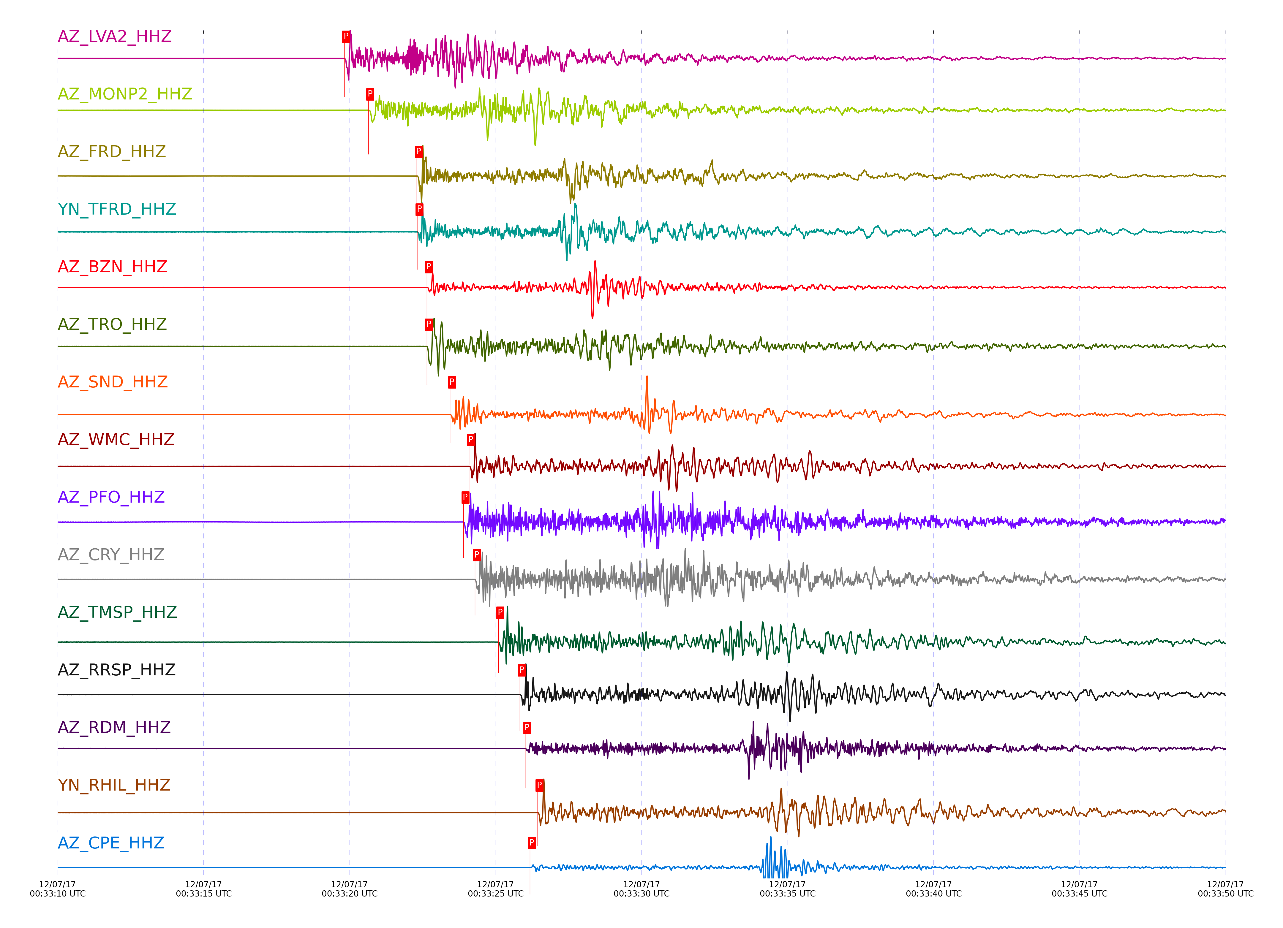
Event and active stations
|
|||||||||||||||||
Closest station with identified signal. Not filtered.
Subset of several stations close to the event. Not filtered.
| STA_CHAN | S-E Delta | S-E Azimuth | Phase | Time | Signal/Noise | Time Residual | V. Model | Auth | arid |
|---|---|---|---|---|---|---|---|---|---|
| LVA2_HHZ | 0.215° | 161.74° | Pg | 2017-12-07 00:33:19.8158 UTC | 954.46 | 0.014 | iasp91 | dbp:jtytell:173 | 1609929 |
| LVA2_HHN | 0.215° | 161.74° | Sg | 2017-12-07 00:33:23.2144 UTC | -1 | 0.189 | iasp91 | dbp:jtytell:173 | 1610237 |
| MONP2_HHZ | 0.26° | 349.1° | Pg | 2017-12-07 00:33:20.6392 UTC | 834.23 | 0.036 | iasp91 | dbp:jtytell:173 | 1609930 |
| MONP2_HHN | 0.26° | 349.1° | Sg | 2017-12-07 00:33:24.3918 UTC | -1 | -0.017 | iasp91 | dbp:jtytell:173 | 1610239 |
| FRD_HHZ | 0.362° | 163.71° | Pg | 2017-12-07 00:33:22.3025 UTC | 821.96 | -0.169 | iasp91 | dbp:jtytell:173 | 1609905 |
| FRD_HHN | 0.362° | 163.71° | Sg | 2017-12-07 00:33:27.06 UTC | -1 | -0.608 | iasp91 | dbp:jtytell:173 | 1610244 |
| TFRD_HHZ | 0.362° | 163.72° | Pg | 2017-12-07 00:33:22.3273 UTC | -1 | -0.146 | iasp91 | dbp:jtytell:173 | 1610117 |
| TFRD_HHE | 0.362° | 163.72° | Sg | 2017-12-07 00:33:27.2348 UTC | -1 | -0.437 | iasp91 | dbp:jtytell:173 | 1610245 |
| BZN_HHZ | 0.378° | 155.65° | Pg | 2017-12-07 00:33:22.6484 UTC | 572.63 | -0.119 | iasp91 | dbp:jtytell:173 | 1609907 |
| BZN_HHN | 0.378° | 155.65° | Sg | 2017-12-07 00:33:27.6839 UTC | -1 | -0.496 | iasp91 | dbp:jtytell:173 | 1610248 |
| TRO_HHZ | 0.379° | 187.02° | Pg | 2017-12-07 00:33:22.6484 UTC | 191.67 | -0.142 | iasp91 | dbp:jtytell:173 | 1609909 |
| SND_HHZ | 0.419° | 164.73° | Pg | 2017-12-07 00:33:23.4427 UTC | 1214.3 | -0.107 | iasp91 | dbp:jtytell:173 | 1609913 |
| SND_HHE | 0.419° | 164.73° | Sg | 2017-12-07 00:33:29.3754 UTC | -1 | -0.154 | iasp91 | dbp:jtytell:173 | 1610278 |
| WMC_HHZ | 0.456° | 159.16° | Pg | 2017-12-07 00:33:24.0863 UTC | 562.68 | -0.153 | iasp91 | dbp:jtytell:173 | 1609915 |
| WMC_HHE | 0.456° | 159.16° | Sg | 2017-12-07 00:33:30.3253 UTC | -1 | -0.394 | iasp91 | dbp:jtytell:173 | 1610280 |
| PFO_HHZ | 0.465° | 182.23° | Pg | 2017-12-07 00:33:23.8973 UTC | 685.35 | -0.507 | iasp91 | dbp:jtytell:173 | 1609936 |
| PFO_HHE | 0.465° | 182.23° | Sg | 2017-12-07 00:33:29.9075 UTC | -1 | -1.098 | iasp91 | dbp:jtytell:173 | 1610286 |
| CRY_HHZ | 0.47° | 152.82° | Pg | 2017-12-07 00:33:24.2884 UTC | 415.12 | -0.21 | iasp91 | dbp:jtytell:173 | 1609917 |
| CRY_HHN | 0.47° | 152.82° | Sg | 2017-12-07 00:33:30.5215 UTC | -1 | -0.645 | iasp91 | dbp:jtytell:173 | 1610288 |
| TMSP_HHZ | 0.501° | 160.47° | Pg | 2017-12-07 00:33:25.0932 UTC | -1 | 0.013 | iasp91 | dbp:jtytell:173 | 1610135 |
| TMSP_HHE | 0.501° | 160.47° | Sg | 2017-12-07 00:33:32.0179 UTC | -1 | -0.153 | iasp91 | dbp:jtytell:173 | 1610294 |
| RRSP_HHZ | 0.548° | 156.76° | Pg | 2017-12-07 00:33:25.8274 UTC | -1 | -0.157 | iasp91 | dbp:jtytell:173 | 1610157 |
| RRSP_HHE | 0.548° | 156.76° | Sg | 2017-12-07 00:33:33.2772 UTC | -1 | -0.453 | iasp91 | dbp:jtytell:173 | 1610298 |
| RDM_HHZ | 0.572° | 147.5° | Pg | 2017-12-07 00:33:26.014 UTC | 148.16 | -0.411 | iasp91 | dbp:jtytell:173 | 1609923 |
| RDM_HHE | 0.572° | 147.5° | Sg | 2017-12-07 00:33:33.4411 UTC | -1 | -1.048 | iasp91 | dbp:jtytell:173 | 1610302 |
| RHIL_HHZ | 0.579° | 155.18° | Pg | 2017-12-07 00:33:26.4347 UTC | -1 | -0.13 | iasp91 | dbp:jtytell:173 | 1610161 |
| RHIL_HHN | 0.579° | 155.18° | Sg | 2017-12-07 00:33:34.2116 UTC | -1 | -0.519 | iasp91 | dbp:jtytell:173 | 1610305 |
| CPE_HHZ | 0.584° | 63.55° | Pg | 2017-12-07 00:33:26.1737 UTC | 235.69 | -0.477 | iasp91 | dbp:jtytell:173 | 1609927 |
| CPE_HHN | 0.584° | 63.55° | Sg | 2017-12-07 00:33:34.1171 UTC | -1 | -0.763 | iasp91 | dbp:jtytell:173 | 1610306 |
| KNW_HHZ | 0.599° | 161.16° | Pg | 2017-12-07 00:33:26.4147 UTC | 797.65 | -0.521 | iasp91 | dbp:jtytell:173 | 1609943 |
| KNW_HHE | 0.599° | 161.16° | Sg | 2017-12-07 00:33:34.252 UTC | -1 | -1.119 | iasp91 | dbp:jtytell:173 | 1610309 |
| SMER_HHZ | 0.655° | 118.11° | Pg | 2017-12-07 00:33:27.157 UTC | 125.27 | -0.842 | iasp91 | dbp:jtytell:173 | 1609928 |
| SMER_HHE | 0.655° | 118.11° | Sg | 2017-12-07 00:33:35.9147 UTC | -1 | -1.291 | iasp91 | dbp:jtytell:173 | 1610315 |
| SIO5_HHZ | 0.714° | 64.36° | Pg | 2017-12-07 00:33:28.6274 UTC | 9.3197 | -0.495 | iasp91 | dbp:jtytell:173 | 1609945 |
| SIO5_HHE | 0.714° | 64.36° | Sg | 2017-12-07 00:33:38.5588 UTC | -1 | -0.583 | iasp91 | dbp:jtytell:173 | 1610356 |
Click the link below to observe an interactive map of earthquakes recorded by the station deployment:
Broadband Seismic Data Collection Center (ANZA),
Institute of Geophysics & Planetary Physics
Scripps Institution of Oceanography,
University of California San Diego
Copyright © 1989 - 2014. All Rights Reserved.