
last update to page: January 10 2018 04:56:20 (UTC).
SummaryThe red marker denotes the earthquake epicenter. On Wed Jan 10th 2018 02:51:31 (UTC) the seismic network recorded an earthquake (preliminary 7.6 mww) located in North Of Honduras. Seismic region Caribbean Loop. The epicentral distance (i.e. distance separating the location to the epicenter) to the closest station USGCB in the network is 3,685.9 km. If you felt the quake, the USGS would like to know. Please add your comments to the USGS page "Did you feel it?". |
Details
Proximity to Population Centers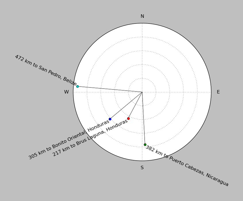
| ||||||||||||||||
Event and active stations
|
|||||||||||||||||
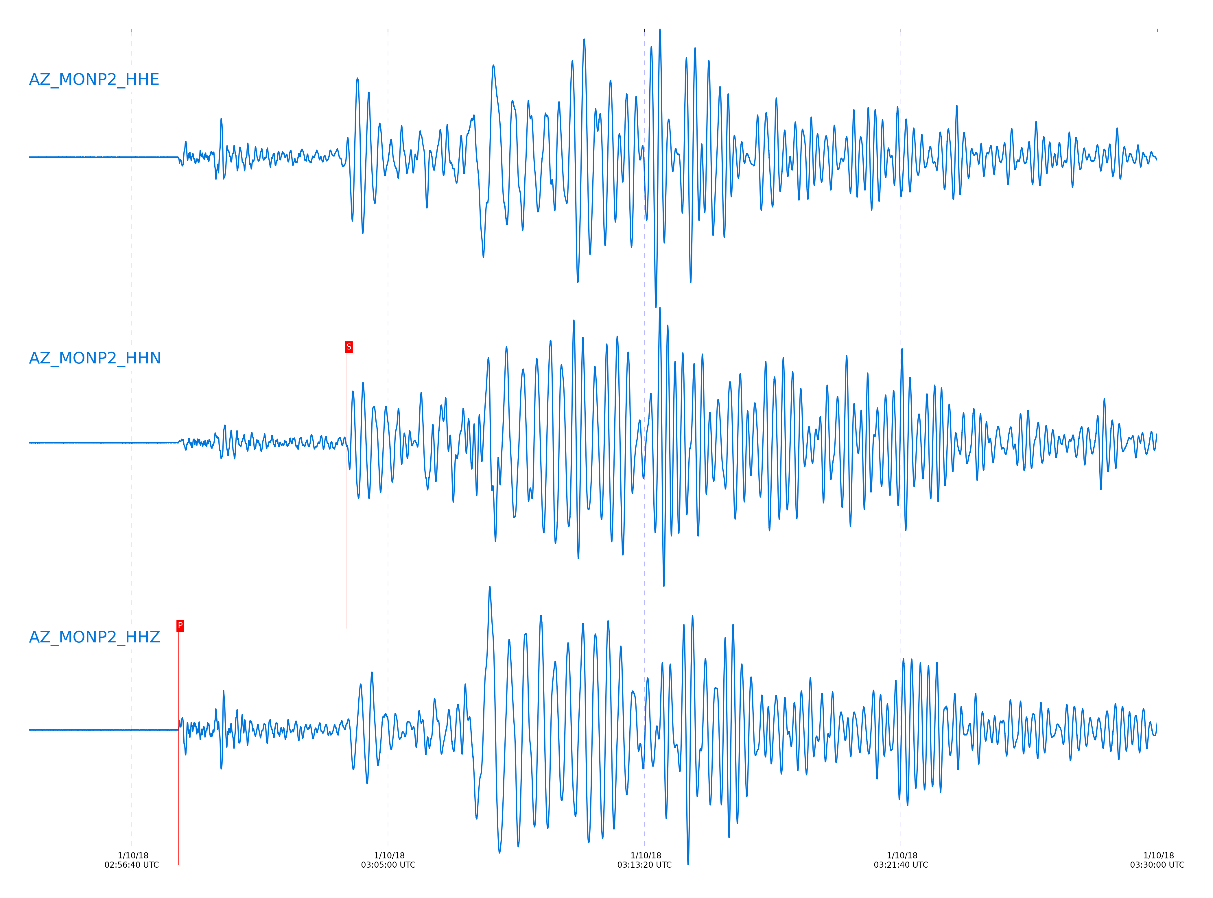
Closest station with identified signal. Not filtered.
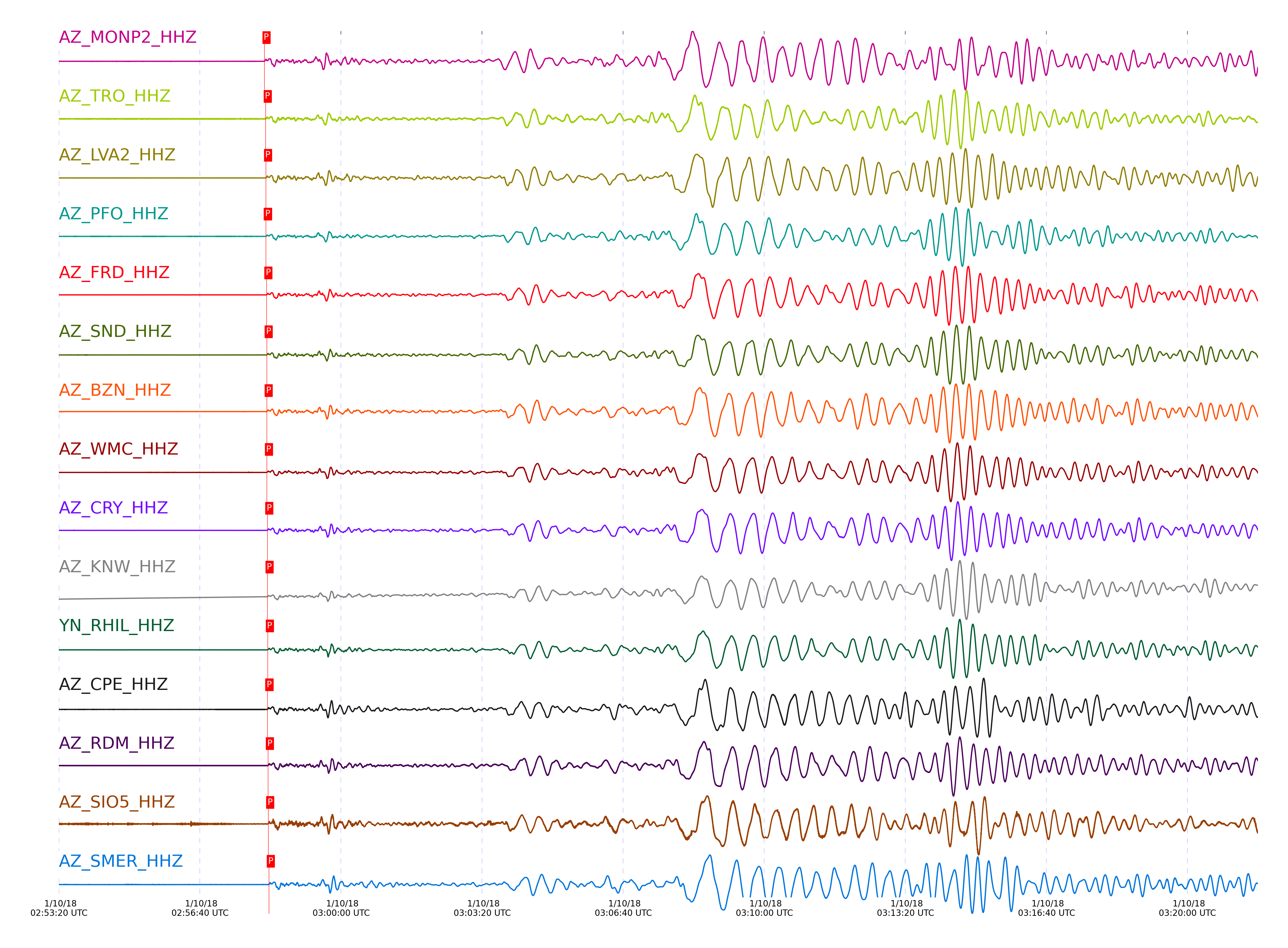
Subset of several stations close to the event. Not filtered.
| STA_CHAN | S-E Delta | S-E Azimuth | Phase | Time | Signal/Noise | Time Residual | V. Model | Auth | arid |
|---|---|---|---|---|---|---|---|---|---|
| MONP2_HHZ | 33.331° | 109.44° | P | 2018-01-10 02:58:11.4525 UTC | -1 | 1.475 | iasp91 | dbp:jtytell:180 | 1653550 |
| MONP2_HHN | 33.331° | 109.44° | S | 2018-01-10 03:03:39.5946 UTC | -1 | 8.058 | iasp91 | dbp:jtytell:180 | 1653599 |
| TRO_HHZ | 33.548° | 110.33° | P | 2018-01-10 02:58:13.2301 UTC | -1 | 1.362 | iasp91 | dbp:jtytell:180 | 1653556 |
| TRO_HHE | 33.548° | 110.33° | S | 2018-01-10 03:03:39.5701 UTC | -1 | 4.669 | iasp91 | dbp:jtytell:180 | 1653610 |
| LVA2_HHZ | 33.596° | 109.96° | P | 2018-01-10 02:58:13.754 UTC | 29.6 | 1.475 | iasp91 | dbp:jtytell:180 | 1653536 |
| LVA2_HHE | 33.596° | 109.96° | S | 2018-01-10 03:03:40.9383 UTC | -1 | 5.306 | iasp91 | dbp:jtytell:180 | 1653612 |
| PFO_HHZ | 33.605° | 110.42° | P | 2018-01-10 02:58:13.4991 UTC | 38.869 | 1.135 | iasp91 | dbp:jtytell:180 | 1653524 |
| PFO_HHE | 33.605° | 110.42° | S | 2018-01-10 03:03:39.1082 UTC | -1 | 3.324 | iasp91 | dbp:jtytell:180 | 1653616 |
| FRD_HHZ | 33.677° | 110.12° | P | 2018-01-10 02:58:14.2869 UTC | 31.966 | 1.305 | iasp91 | dbp:jtytell:180 | 1653538 |
| FRD_HHE | 33.677° | 110.12° | S | 2018-01-10 03:03:43.557 UTC | -1 | 6.674 | iasp91 | dbp:jtytell:180 | 1653621 |
| SND_HHZ | 33.705° | 110.19° | P | 2018-01-10 02:58:14.6443 UTC | 27.049 | 1.418 | iasp91 | dbp:jtytell:180 | 1653543 |
| SND_HHE | 33.705° | 110.19° | S | 2018-01-10 03:03:43.322 UTC | -1 | 6.004 | iasp91 | dbp:jtytell:180 | 1653625 |
| BZN_HHZ | 33.726° | 110.05° | P | 2018-01-10 02:58:14.7749 UTC | 45.699 | 1.362 | iasp91 | dbp:jtytell:180 | 1653528 |
| BZN_HHE | 33.726° | 110.05° | S | 2018-01-10 03:03:42.0726 UTC | -1 | 4.422 | iasp91 | dbp:jtytell:180 | 1653628 |
| WMC_HHZ | 33.76° | 110.16° | P | 2018-01-10 02:58:14.9019 UTC | 33.539 | 1.191 | iasp91 | dbp:jtytell:180 | 1653534 |
| WMC_HHE | 33.76° | 110.16° | S | 2018-01-10 03:03:43.3277 UTC | -1 | 5.147 | iasp91 | dbp:jtytell:180 | 1653630 |
| CRY_HHZ | 33.807° | 110.08° | P | 2018-01-10 02:58:15.5295 UTC | 43.153 | 1.418 | iasp91 | dbp:jtytell:180 | 1653540 |
| CRY_HHE | 33.807° | 110.08° | S | 2018-01-10 03:03:42.7705 UTC | -1 | 3.877 | iasp91 | dbp:jtytell:180 | 1653632 |
| KNW_HHZ | 33.838° | 110.32° | P | 2018-01-10 02:58:15.9163 UTC | 40.894 | 1.532 | iasp91 | dbp:jtytell:180 | 1653530 |
| KNW_HHE | 33.838° | 110.32° | S | 2018-01-10 03:03:44.4805 UTC | -1 | 5.1 | iasp91 | dbp:jtytell:180 | 1653635 |
| RHIL_HHZ | 33.87° | 110.2° | P | 2018-01-10 02:58:16.1957 UTC | -1 | 1.532 | iasp91 | dbp:jtytell:180 | 1653575 |
| RHIL_HHE | 33.87° | 110.2° | S | 2018-01-10 03:03:45.2387 UTC | -1 | 5.361 | iasp91 | dbp:jtytell:180 | 1653636 |
| CPE_HHZ | 33.872° | 108.78° | P | 2018-01-10 02:58:15.697 UTC | -1 | 1.021 | iasp91 | dbp:jtytell:180 | 1653576 |
| CPE_HHE | 33.872° | 108.78° | S | 2018-01-10 03:03:44.2929 UTC | -1 | 4.394 | iasp91 | dbp:jtytell:180 | 1653637 |
| RDM_HHZ | 33.915° | 110.07° | P | 2018-01-10 02:58:16.4718 UTC | 42.056 | 1.418 | iasp91 | dbp:jtytell:180 | 1653542 |
| RDM_HHE | 33.915° | 110.07° | S | 2018-01-10 03:03:46.5861 UTC | -1 | 6.015 | iasp91 | dbp:jtytell:180 | 1653639 |
| SIO5_HHZ | 33.971° | 108.57° | P | 2018-01-10 02:58:16.8446 UTC | -1 | 1.305 | iasp91 | dbp:jtytell:180 | 1653579 |
| SIO5_HHE | 33.971° | 108.57° | S | 2018-01-10 03:03:45.1568 UTC | -1 | 3.719 | iasp91 | dbp:jtytell:180 | 1653641 |
| SMER_HHZ | 34.11° | 109.51° | P | 2018-01-10 02:58:17.7644 UTC | -1 | 1.021 | iasp91 | dbp:jtytell:180 | 1653584 |
| SMER_HHE | 34.11° | 109.51° | S | 2018-01-10 03:03:49.2337 UTC | -1 | 5.653 | iasp91 | dbp:jtytell:180 | 1653646 |
Click the link below to observe an interactive map of earthquakes recorded by the station deployment:
Broadband Seismic Data Collection Center (ANZA),
Institute of Geophysics & Planetary Physics
Scripps Institution of Oceanography,
University of California San Diego
Copyright © 1989 - 2014. All Rights Reserved.