
last update to page: January 14 2018 22:04:13 (UTC).
SummaryThe red marker denotes the earthquake epicenter. On Sat Jan 13th 2018 06:26:57 (UTC) the seismic network recorded an earthquake (preliminary 3.63 ml) located in Southern California. Seismic region California - Nevada Region. The epicentral distance (i.e. distance separating the location to the epicenter) to the closest station TONN in the network is 3.0 km. If you felt the quake, the USGS would like to know. Please add your comments to the USGS page "Did you feel it?". |
Details
Proximity to Population Centers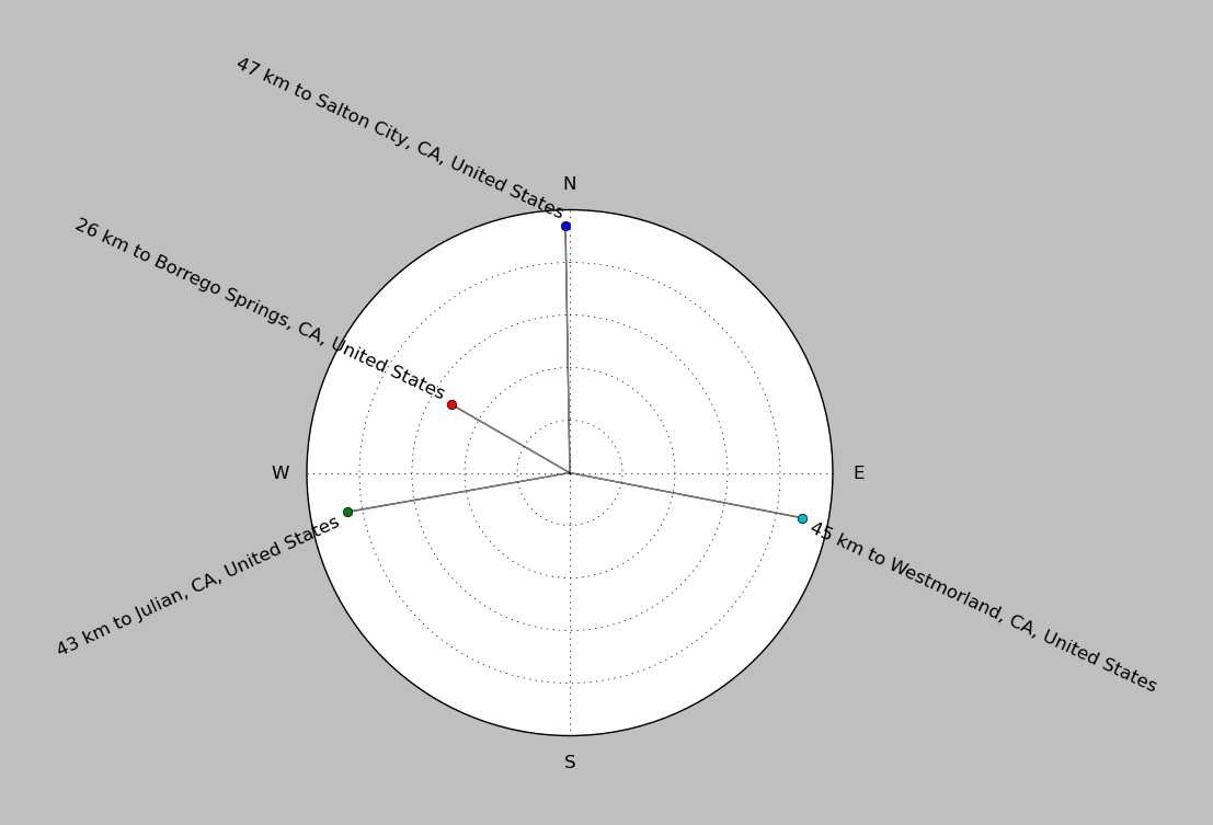
| ||||||||||||||||
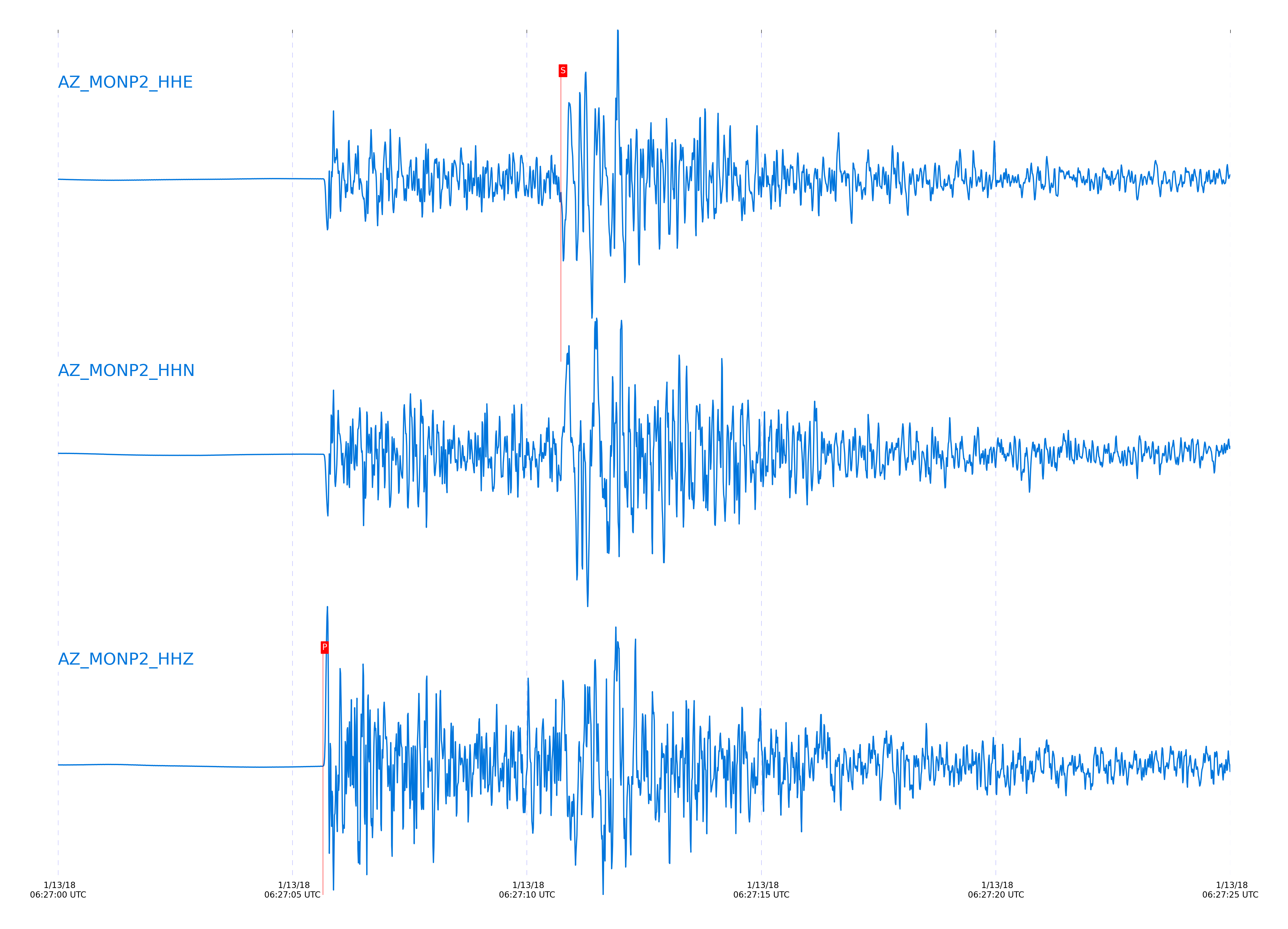
Event and active stations
|
|||||||||||||||||
Closest station with identified signal. Not filtered.
Subset of several stations close to the event. Not filtered.
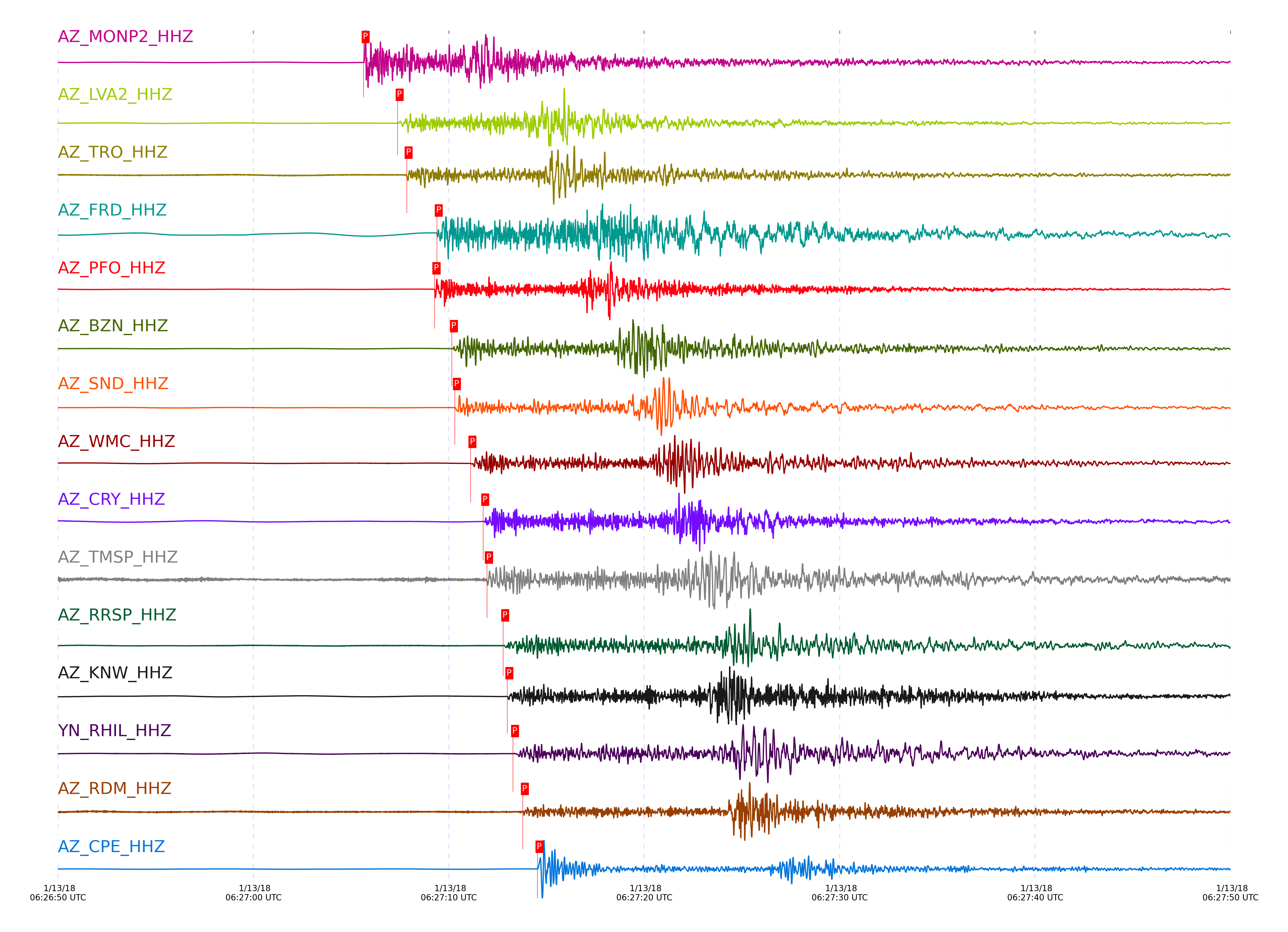
| STA_CHAN | S-E Delta | S-E Azimuth | Phase | Time | Signal/Noise | Time Residual | V. Model | Auth | arid |
|---|---|---|---|---|---|---|---|---|---|
| MONP2_HHZ | 0.347° | 49.08° | P | 2018-01-13 06:27:05.6484 UTC | 1695.6 | 0.398 | iasp91 | dbp:jtytell:180 | 1656746 |
| MONP2_HHE | 0.347° | 49.08° | S | 2018-01-13 06:27:10.7225 UTC | -1 | 0.186 | iasp91 | dbp:jtytell:180 | 1657711 |
| LVA2_HHZ | 0.444° | 121.47° | P | 2018-01-13 06:27:07.3831 UTC | 957.27 | 0.414 | iasp91 | dbp:jtytell:180 | 1656788 |
| LVA2_HHE | 0.444° | 121.47° | S | 2018-01-13 06:27:14.1155 UTC | -1 | 0.608 | iasp91 | dbp:jtytell:180 | 1657715 |
| TRO_HHZ | 0.483° | 146.74° | P | 2018-01-13 06:27:07.8484 UTC | 25.467 | 0.025 | iasp91 | dbp:jtytell:180 | 1656748 |
| TRO_HHN | 0.483° | 146.74° | S | 2018-01-13 06:27:14.9472 UTC | -1 | -0.067 | iasp91 | dbp:jtytell:180 | 1657717 |
| FRD_HHZ | 0.558° | 132.23° | P | 2018-01-13 06:27:09.3884 UTC | 711.66 | 0.335 | iasp91 | dbp:jtytell:180 | 1656752 |
| FRD_HHN | 0.558° | 132.23° | S | 2018-01-13 06:27:17.2123 UTC | -1 | 0.088 | iasp91 | dbp:jtytell:180 | 1657724 |
| TFRD_HHN | 0.558° | 132.24° | S | 2018-01-13 06:27:17.2244 UTC | -1 | 0.131 | iasp91 | dbp:jtytell:180 | 1657725 |
| JORD_HHN | 0.57° | 128.12° | S | 2018-01-13 06:27:17.583 UTC | -1 | 0.03 | iasp91 | dbp:jtytell:180 | 1657734 |
| PFO_HHZ | 0.573° | 149.22° | P | 2018-01-13 06:27:09.2716 UTC | 742.84 | -0.083 | iasp91 | dbp:jtytell:180 | 1656751 |
| PFO_HHE | 0.573° | 149.22° | S | 2018-01-13 06:27:17.0045 UTC | -1 | -0.639 | iasp91 | dbp:jtytell:180 | 1657732 |
| BZN_HHZ | 0.597° | 128.48° | P | 2018-01-13 06:27:10.1584 UTC | 837.8 | 0.353 | iasp91 | dbp:jtytell:180 | 1656755 |
| BZN_HHE | 0.597° | 128.48° | S | 2018-01-13 06:27:18.4167 UTC | -1 | -0.006 | iasp91 | dbp:jtytell:180 | 1657736 |
| SND_HHZ | 0.604° | 135.68° | P | 2018-01-13 06:27:10.3144 UTC | 337.14 | 0.372 | iasp91 | dbp:jtytell:180 | 1656756 |
| SND_HHN | 0.604° | 135.68° | S | 2018-01-13 06:27:19.0184 UTC | -1 | 0.356 | iasp91 | dbp:jtytell:180 | 1657737 |
| WMC_HHZ | 0.656° | 133.75° | P | 2018-01-13 06:27:11.1132 UTC | 117.96 | 0.202 | iasp91 | dbp:jtytell:180 | 1656757 |
| WMC_HHE | 0.656° | 133.75° | S | 2018-01-13 06:27:20.5973 UTC | -1 | 0.266 | iasp91 | dbp:jtytell:180 | 1657741 |
| CRY_HHZ | 0.689° | 130.22° | P | 2018-01-13 06:27:11.7653 UTC | 367.62 | 0.241 | iasp91 | dbp:jtytell:180 | 1656758 |
| CRY_HHE | 0.689° | 130.22° | S | 2018-01-13 06:27:21.3154 UTC | -1 | -0.071 | iasp91 | dbp:jtytell:180 | 1657746 |
| TMSP_HHZ | 0.692° | 136.18° | P | 2018-01-13 06:27:11.9562 UTC | -1 | 0.283 | iasp91 | dbp:jtytell:180 | 1657679 |
| TMSP_HHE | 0.692° | 136.18° | S | 2018-01-13 06:27:21.7351 UTC | -1 | 0.071 | iasp91 | dbp:jtytell:180 | 1657747 |
| RRSP_HHZ | 0.749° | 135.17° | P | 2018-01-13 06:27:12.7823 UTC | -1 | 0.078 | iasp91 | dbp:jtytell:180 | 1657683 |
| RRSP_HHN | 0.749° | 135.17° | S | 2018-01-13 06:27:23.3419 UTC | -1 | -0.091 | iasp91 | dbp:jtytell:180 | 1657755 |
| KNW_HHZ | 0.779° | 139.63° | P | 2018-01-13 06:27:12.9984 UTC | 514.27 | -0.275 | iasp91 | dbp:jtytell:180 | 1656761 |
| KNW_HHE | 0.779° | 139.63° | S | 2018-01-13 06:27:23.2627 UTC | -1 | -1.148 | iasp91 | dbp:jtytell:180 | 1657758 |
| RHIL_HHZ | 0.783° | 134.9° | P | 2018-01-13 06:27:13.2886 UTC | -1 | -0.056 | iasp91 | dbp:jtytell:180 | 1657687 |
| RHIL_HHE | 0.783° | 134.9° | S | 2018-01-13 06:27:24.6814 UTC | -1 | 0.146 | iasp91 | dbp:jtytell:180 | 1657759 |
| RDM_HHZ | 0.801° | 129.44° | P | 2018-01-13 06:27:13.7898 UTC | 8.9843 | 0.107 | iasp91 | dbp:jtytell:180 | 1656762 |
| RDM_HHN | 0.801° | 129.44° | S | 2018-01-13 06:27:24.3998 UTC | -1 | -0.706 | iasp91 | dbp:jtytell:180 | 1657762 |
| CPE_HHZ | 0.866° | 74.33° | P | 2018-01-13 06:27:14.5384 UTC | 516.27 | -0.189 | iasp91 | dbp:jtytell:180 | 1656764 |
| CPE_HHN | 0.866° | 74.33° | S | 2018-01-13 06:27:26.2101 UTC | -1 | -0.694 | iasp91 | dbp:jtytell:180 | 1657764 |
| SMER_HHZ | 0.95° | 110.6° | P | 2018-01-13 06:27:15.9918 UTC | 122.73 | -0.268 | iasp91 | dbp:jtytell:180 | 1656775 |
| SMER_HHN | 0.95° | 110.6° | S | 2018-01-13 06:27:28.7221 UTC | -1 | -0.84 | iasp91 | dbp:jtytell:180 | 1657771 |
| SIO5_HHZ | 0.997° | 73.47° | P | 2018-01-13 06:27:16.9322 UTC | 11.614 | -0.137 | iasp91 | dbp:jtytell:180 | 1656776 |
| SIO5_HHE | 0.997° | 73.47° | S | 2018-01-13 06:27:31.2289 UTC | -1 | 0.256 | iasp91 | dbp:jtytell:180 | 1657773 |
Click the link below to observe an interactive map of earthquakes recorded by the station deployment:
Broadband Seismic Data Collection Center (ANZA),
Institute of Geophysics & Planetary Physics
Scripps Institution of Oceanography,
University of California San Diego
Copyright © 1989 - 2014. All Rights Reserved.