
last update to page: February 09 2018 19:31:36 (UTC).
SummaryThe red marker denotes the earthquake epicenter. On Fri Feb 9th 2018 14:05:47 (UTC) the seismic network recorded an earthquake (preliminary 5.8 mww) located in Near Coast Of Jalisco, Mexico. Seismic region Mexico - Guatemala Area. The epicentral distance (i.e. distance separating the location to the epicenter) to the closest station USGCB in the network is 1,935.9 km. If you felt the quake, the USGS would like to know. Please add your comments to the USGS page "Did you feel it?". |
Details
Proximity to Population Centers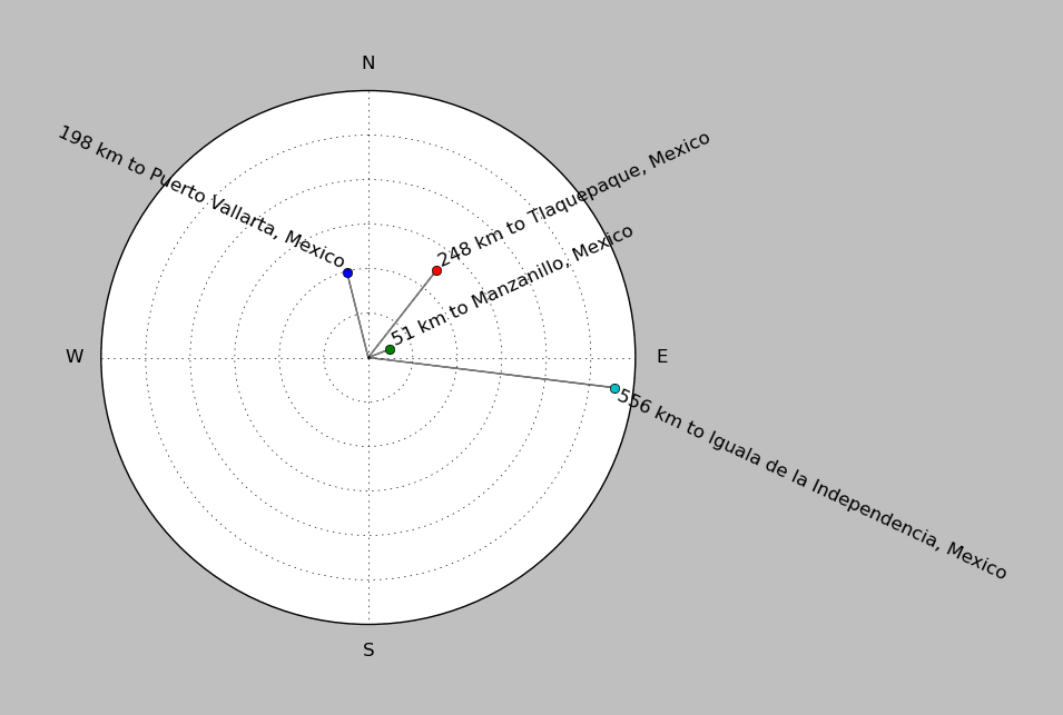
| ||||||||||||||||
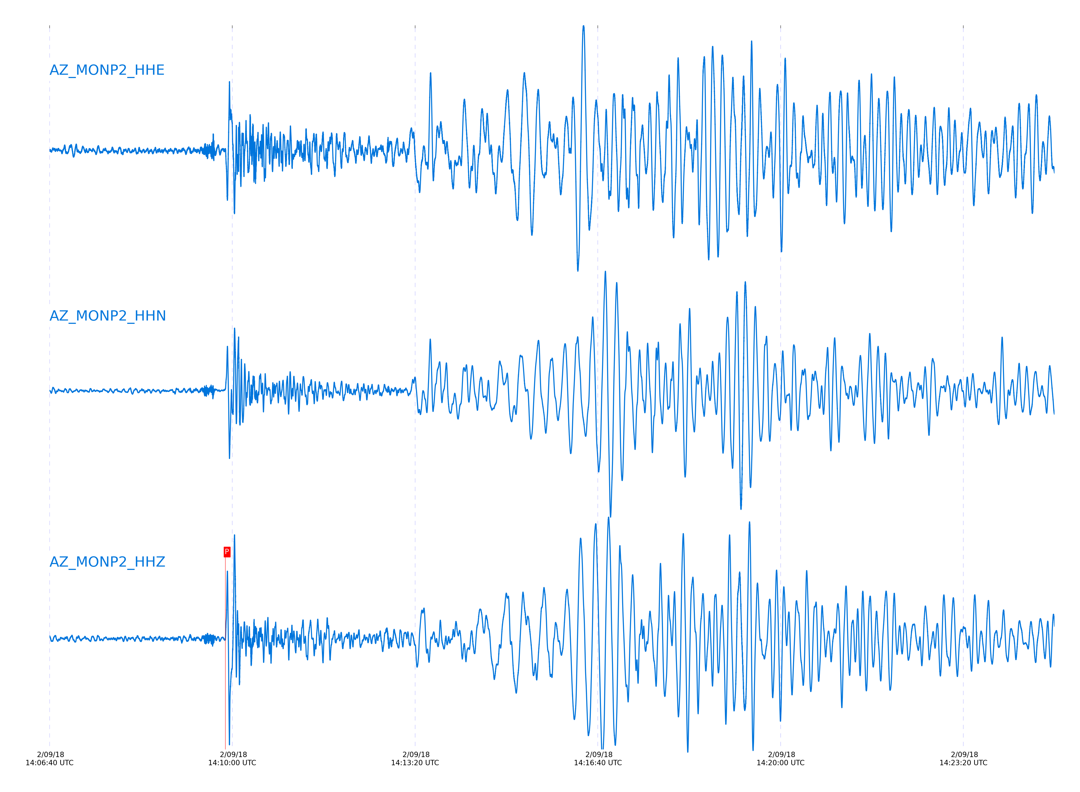
Event and active stations
|
|||||||||||||||||
Closest station with identified signal. Not filtered.
Subset of several stations close to the event. Not filtered.
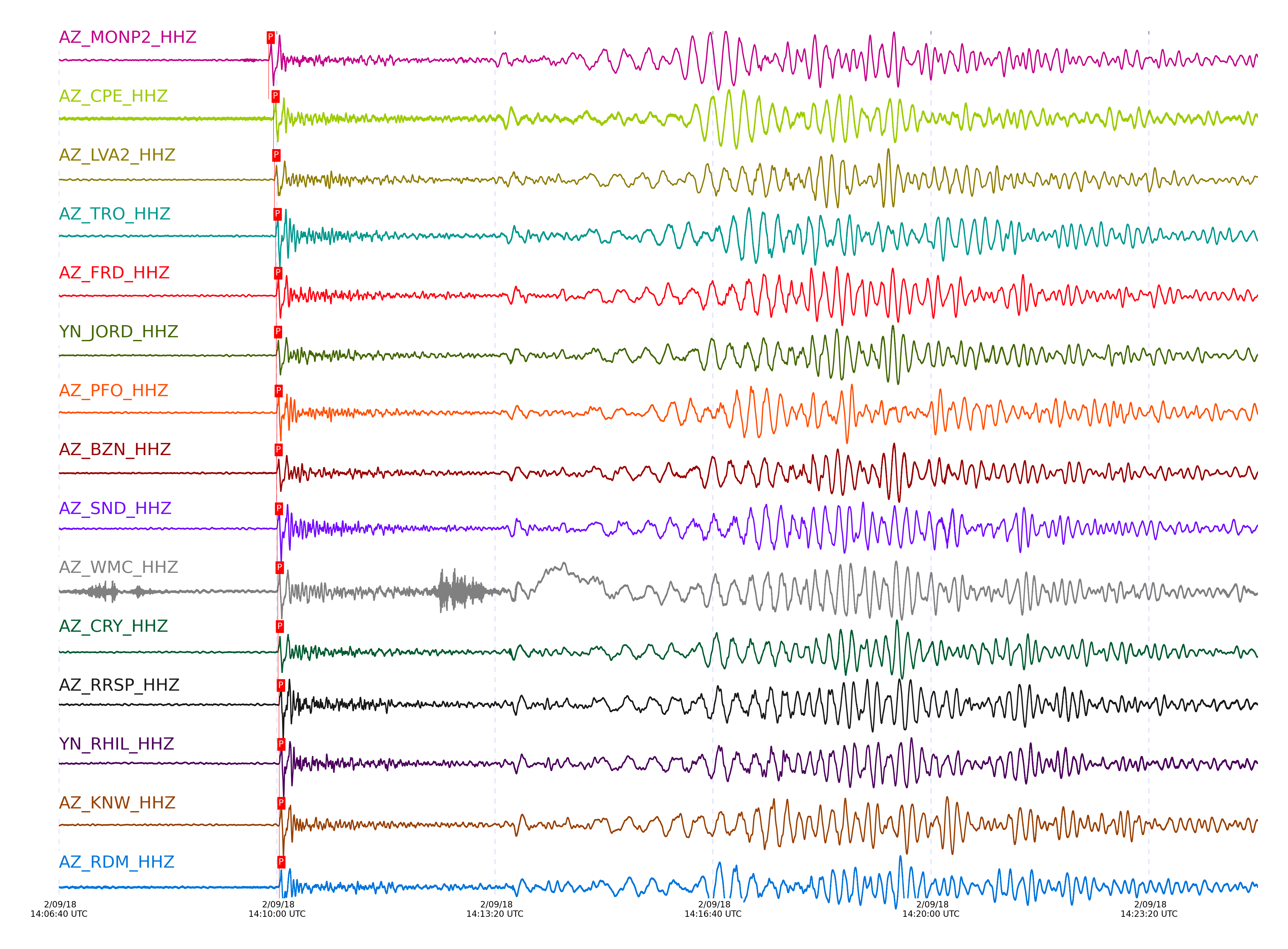
| STA_CHAN | S-E Delta | S-E Azimuth | Phase | Time | Signal/Noise | Time Residual | V. Model | Auth | arid |
|---|---|---|---|---|---|---|---|---|---|
| MONP2_HHZ | 17.461° | 140.46° | P | 2018-02-09 14:09:52.5689 UTC | -1 | -0.063 | iasp91 | dbp:jtytell:180 | 1680321 |
| CPE_HHZ | 17.83° | 138.71° | P | 2018-02-09 14:09:56.9477 UTC | 35.158 | 0.236 | iasp91 | dbp:jtytell:180 | 1680053 |
| LVA2_HHZ | 17.89° | 141.01° | P | 2018-02-09 14:09:57.7411 UTC | 45.853 | 0.365 | iasp91 | dbp:jtytell:180 | 1680055 |
| TRO_HHZ | 17.954° | 141.69° | P | 2018-02-09 14:09:58.8209 UTC | 69.689 | 0.745 | iasp91 | dbp:jtytell:180 | 1680061 |
| FRD_HHZ | 18.023° | 141.19° | P | 2018-02-09 14:09:59.3758 UTC | 35.342 | 0.536 | iasp91 | dbp:jtytell:180 | 1680059 |
| JORD_HHZ | 18.028° | 141.04° | P | 2018-02-09 14:09:59.287 UTC | 43.238 | 0.393 | iasp91 | dbp:jtytell:180 | 1680065 |
| PFO_HHZ | 18.041° | 141.78° | P | 2018-02-09 14:09:59.8387 UTC | 106.26 | 0.806 | iasp91 | dbp:jtytell:180 | 1680069 |
| BZN_HHZ | 18.055° | 141.02° | P | 2018-02-09 14:09:59.7625 UTC | 37.322 | 0.576 | iasp91 | dbp:jtytell:180 | 1680067 |
| SND_HHZ | 18.073° | 141.27° | P | 2018-02-09 14:10:00.142 UTC | 43.737 | 0.748 | iasp91 | dbp:jtytell:180 | 1680071 |
| WMC_HHZ | 18.123° | 141.16° | P | 2018-02-09 14:10:00.7664 UTC | 57.221 | 0.831 | iasp91 | dbp:jtytell:180 | 1680073 |
| CRY_HHZ | 18.149° | 140.98° | P | 2018-02-09 14:10:00.9648 UTC | 54.298 | 0.738 | iasp91 | dbp:jtytell:180 | 1680075 |
| TMSP_HHZ | 18.161° | 141.23° | pPn | 2018-02-09 14:10:01.6194 UTC | -1 | -1.105 | iasp91 | dbp:jtytell:180 | 1680342 |
| RRSP_HHZ | 18.217° | 141.14° | P | 2018-02-09 14:10:01.9254 UTC | -1 | 0.949 | iasp91 | dbp:jtytell:180 | 1680343 |
| RHIL_HHZ | 18.251° | 141.1° | P | 2018-02-09 14:10:02.2548 UTC | -1 | 0.908 | iasp91 | dbp:jtytell:180 | 1680345 |
| KNW_HHZ | 18.251° | 141.33° | P | 2018-02-09 14:10:02.2661 UTC | 97.802 | 0.91 | iasp91 | dbp:jtytell:180 | 1680077 |
| RDM_HHZ | 18.257° | 140.83° | P | 2018-02-09 14:10:02.3351 UTC | 49.676 | 0.916 | iasp91 | dbp:jtytell:180 | 1680078 |
| SMER_HHZ | 18.297° | 139.69° | P | 2018-02-09 14:10:02.1107 UTC | 29.834 | 0.256 | iasp91 | dbp:jtytell:180 | 1680079 |
Click the link below to observe an interactive map of earthquakes recorded by the station deployment:
Broadband Seismic Data Collection Center (ANZA),
Institute of Geophysics & Planetary Physics
Scripps Institution of Oceanography,
University of California San Diego
Copyright © 1989 - 2014. All Rights Reserved.