
last update to page: February 26 2018 20:40:28 (UTC).
SummaryThe red marker denotes the earthquake epicenter. On Mon Feb 26th 2018 18:44:41 (UTC) the seismic network recorded an earthquake (preliminary 3.66 ml) located in Southern California. Seismic region California - Nevada Region. The epicentral distance (i.e. distance separating the location to the epicenter) to the closest station ALCY in the network is 4.3 km. If you felt the quake, the USGS would like to know. Please add your comments to the USGS page "Did you feel it?". |
Details
Proximity to Population Centers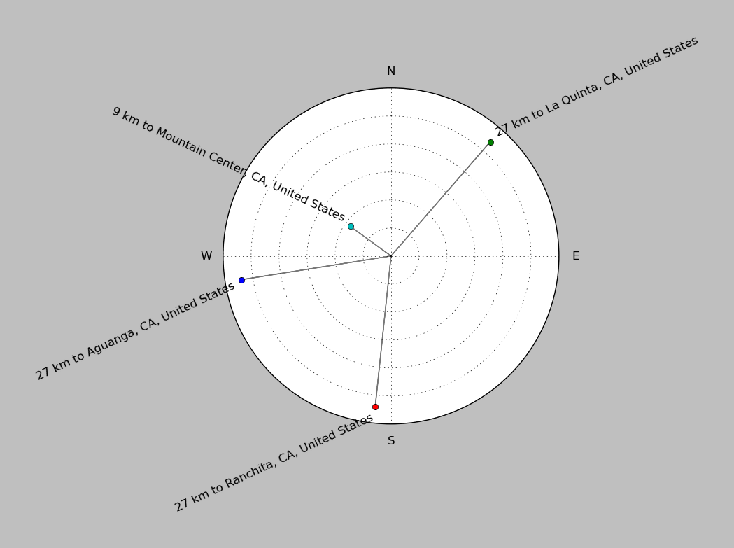
| ||||||||||||||||
Event and active stations
|
|||||||||||||||||
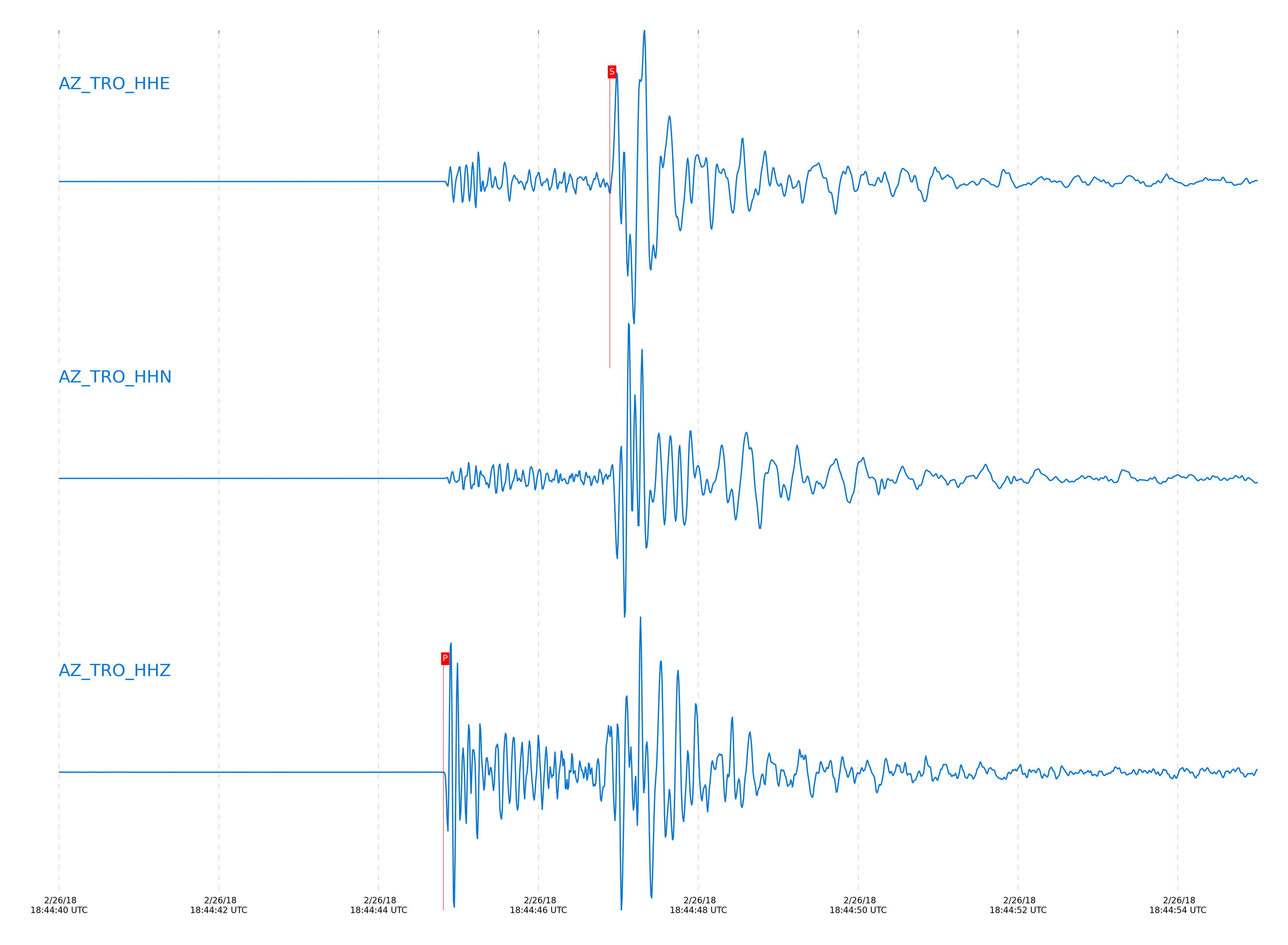
Closest station with identified signal. Not filtered.
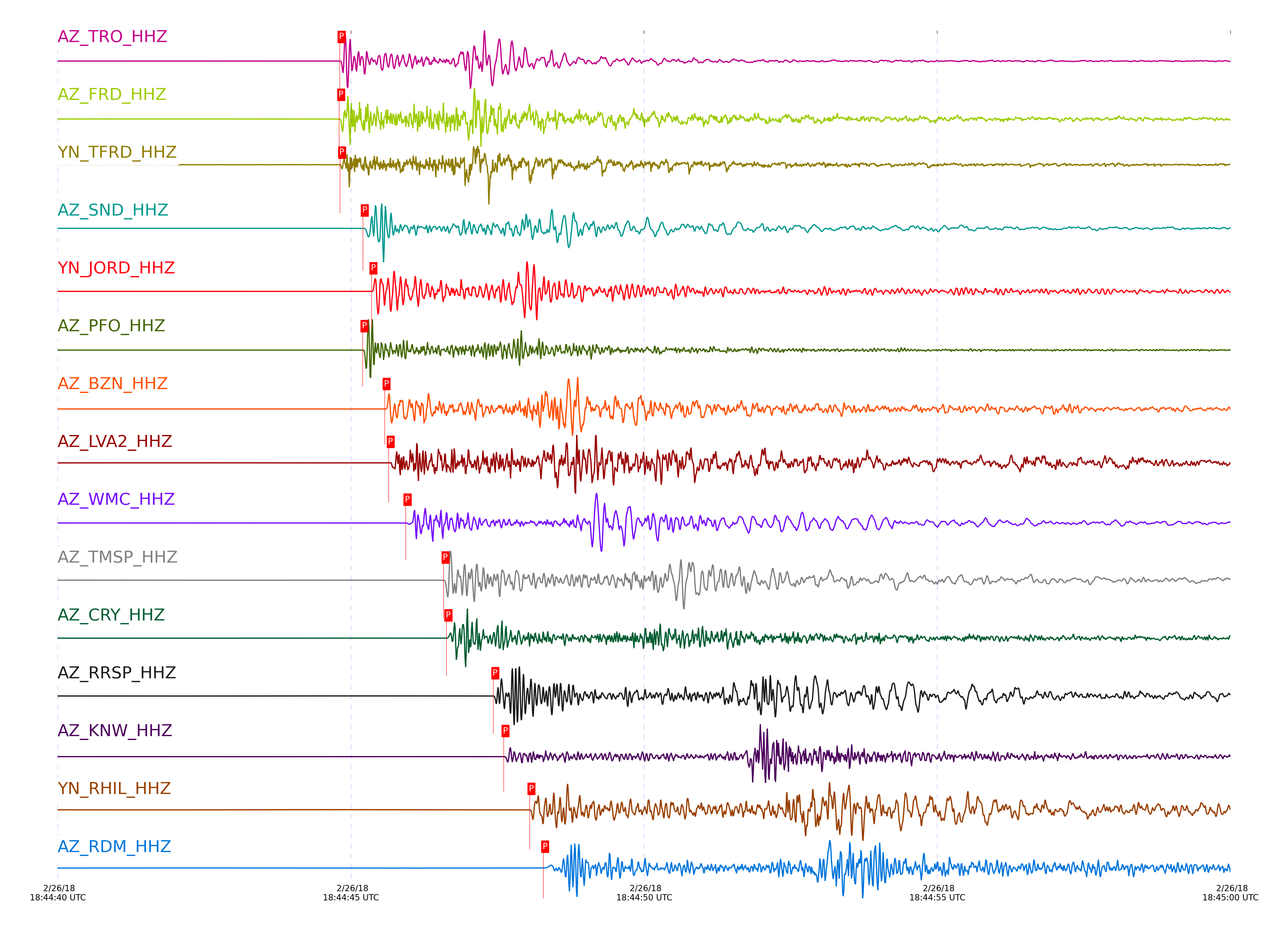
Subset of several stations close to the event. Not filtered.
| STA_CHAN | S-E Delta | S-E Azimuth | Phase | Time | Signal/Noise | Time Residual | V. Model | Auth | arid |
|---|---|---|---|---|---|---|---|---|---|
| TRO_HHZ | 0.077° | 237.86° | Pg | 2018-02-26 18:44:44.8084 UTC | 6671.2 | 0.179 | iasp91 | dbp:jtytell:180 | 1694046 |
| TRO_HHE | 0.077° | 237.86° | Sg | 2018-02-26 18:44:46.8937 UTC | -1 | 0.214 | iasp91 | dbp:jtytell:180 | 1694408 |
| FRD_HHZ | 0.083° | 98.42° | Pg | 2018-02-26 18:44:44.7984 UTC | 7547.3 | 0.102 | iasp91 | dbp:jtytell:180 | 1694044 |
| FRD_HHE | 0.083° | 98.42° | Sg | 2018-02-26 18:44:46.9271 UTC | -1 | 0.128 | iasp91 | dbp:jtytell:180 | 1694409 |
| TFRD_HHZ | 0.083° | 98.49° | Pg | 2018-02-26 18:44:44.8139 UTC | -1 | 0.118 | iasp91 | dbp:jtytell:180 | 1694347 |
| TFRD_HHE | 0.083° | 98.49° | Sg | 2018-02-26 18:44:46.9216 UTC | -1 | 0.122 | iasp91 | dbp:jtytell:180 | 1694410 |
| SND_HHZ | 0.114° | 127.29° | Pg | 2018-02-26 18:44:45.2028 UTC | 12418 | 0.122 | iasp91 | dbp:jtytell:180 | 1694050 |
| SND_HHE | 0.114° | 127.29° | Sg | 2018-02-26 18:44:47.9027 UTC | -1 | 0.441 | iasp91 | dbp:jtytell:180 | 1694413 |
| JORD_HHZ | 0.118° | 84.97° | Pg | 2018-02-26 18:44:45.3509 UTC | 12608 | 0.219 | iasp91 | dbp:jtytell:180 | 1694053 |
| JORD_HHN | 0.118° | 84.97° | Sg | 2018-02-26 18:44:47.6686 UTC | -1 | 0.12 | iasp91 | dbp:jtytell:180 | 1694414 |
| PFO_HHZ | 0.134° | 195.96° | Pg | 2018-02-26 18:44:45.1984 UTC | 9956.7 | -0.159 | iasp91 | dbp:jtytell:180 | 1694052 |
| PFO_HHE | 0.134° | 195.96° | sPg | 2018-02-26 18:44:47.5181 UTC | -1 | -0.101 | iasp91 | dbp:jtytell:180 | 1694418 |
| BZN_HHZ | 0.136° | 93.74° | Pg | 2018-02-26 18:44:45.5743 UTC | 5188.7 | 0.186 | iasp91 | dbp:jtytell:180 | 1694054 |
| BZN_HHN | 0.136° | 93.74° | Sg | 2018-02-26 18:44:48.0979 UTC | -1 | 0.123 | iasp91 | dbp:jtytell:180 | 1694423 |
| LVA2_HHZ | 0.14° | 20.22° | Pg | 2018-02-26 18:44:45.6431 UTC | 2059.6 | 0.211 | iasp91 | dbp:jtytell:180 | 1694055 |
| LVA2_HHN | 0.14° | 20.22° | Sg | 2018-02-26 18:44:48.3153 UTC | -1 | 0.267 | iasp91 | dbp:jtytell:180 | 1694424 |
| WMC_HHZ | 0.169° | 122.53° | Pg | 2018-02-26 18:44:45.9311 UTC | 2054.5 | 0.042 | iasp91 | dbp:jtytell:180 | 1694056 |
| WMC_HHN | 0.169° | 122.53° | Sg | 2018-02-26 18:44:48.9787 UTC | -1 | 0.181 | iasp91 | dbp:jtytell:180 | 1694428 |
| TMSP_HHZ | 0.201° | 132.74° | Pg | 2018-02-26 18:44:46.578 UTC | -1 | 0.16 | iasp91 | dbp:jtytell:180 | 1694357 |
| TMSP_HHN | 0.201° | 132.74° | Sg | 2018-02-26 18:44:50.1996 UTC | -1 | 0.539 | iasp91 | dbp:jtytell:180 | 1694432 |
| CRY_HHZ | 0.212° | 112.99° | Pg | 2018-02-26 18:44:46.6284 UTC | 2376.8 | 0.034 | iasp91 | dbp:jtytell:180 | 1694057 |
| CRY_HHN | 0.212° | 112.99° | Sg | 2018-02-26 18:44:49.8038 UTC | -1 | -0.148 | iasp91 | dbp:jtytell:180 | 1694435 |
| GVAR1_HHN | 0.25° | 137.34° | Sg | 2018-02-26 18:44:50.9243 UTC | -1 | -0.125 | iasp91 | dbp:jtytell:180 | 1694440 |
| RRSP_HHZ | 0.259° | 130.65° | Pg | 2018-02-26 18:44:47.4274 UTC | -1 | 0.012 | iasp91 | dbp:jtytell:180 | 1694363 |
| RRSP_HHE | 0.259° | 130.65° | Sg | 2018-02-26 18:44:51.61 UTC | -1 | 0.282 | iasp91 | dbp:jtytell:180 | 1694442 |
| KNW_HHZ | 0.289° | 143.12° | Pg | 2018-02-26 18:44:47.6031 UTC | 1743.2 | -0.346 | iasp91 | dbp:jtytell:180 | 1694060 |
| KNW_HHN | 0.289° | 143.12° | Sg | 2018-02-26 18:44:51.7048 UTC | -1 | -0.536 | iasp91 | dbp:jtytell:180 | 1694446 |
| RHIL_HHZ | 0.293° | 130.47° | Pg | 2018-02-26 18:44:48.045 UTC | -1 | 0.024 | iasp91 | dbp:jtytell:180 | 1694367 |
| RHIL_HHN | 0.293° | 130.47° | Sg | 2018-02-26 18:44:52.7473 UTC | -1 | 0.382 | iasp91 | dbp:jtytell:180 | 1694447 |
| RDM_HHZ | 0.322° | 117.13° | Pg | 2018-02-26 18:44:48.2787 UTC | 1129.4 | -0.263 | iasp91 | dbp:jtytell:180 | 1694061 |
| RDM_HHN | 0.322° | 117.13° | Sg | 2018-02-26 18:44:53.2546 UTC | -1 | -0.011 | iasp91 | dbp:jtytell:180 | 1694448 |
| SMER_HHZ | 0.557° | 87.26° | Pg | 2018-02-26 18:44:52.3755 UTC | 577.14 | -0.51 | iasp91 | dbp:jtytell:180 | 1694062 |
| SMER_HHN | 0.557° | 87.26° | Sg | 2018-02-26 18:44:59.8033 UTC | -1 | -1.01 | iasp91 | dbp:jtytell:180 | 1694459 |
| MONP2_HHZ | 0.594° | 353.44° | Pg | 2018-02-26 18:44:53.2622 UTC | 770.13 | -0.328 | iasp91 | dbp:jtytell:180 | 1694075 |
| MONP2_HHN | 0.594° | 353.44° | Sg | 2018-02-26 18:45:01.1879 UTC | -1 | -0.841 | iasp91 | dbp:jtytell:180 | 1694462 |
| CPE_HHZ | 0.778° | 40.13° | Pg | 2018-02-26 18:44:56.1084 UTC | 79.709 | -0.958 | iasp91 | dbp:jtytell:180 | 1694076 |
| CPE_HHN | 0.778° | 40.13° | Sg | 2018-02-26 18:45:06.1108 UTC | -1 | -1.913 | iasp91 | dbp:jtytell:180 | 1694471 |
| SIO5_HHZ | 0.895° | 44.01° | Pg | 2018-02-26 18:44:58.3575 UTC | -1 | -0.932 | iasp91 | dbp:jtytell:180 | 1694398 |
| SIO5_HHN | 0.895° | 44.01° | Sg | 2018-02-26 18:45:10.1939 UTC | -1 | -1.665 | iasp91 | dbp:jtytell:180 | 1694480 |
Click the link below to observe an interactive map of earthquakes recorded by the station deployment:
Broadband Seismic Data Collection Center (ANZA),
Institute of Geophysics & Planetary Physics
Scripps Institution of Oceanography,
University of California San Diego
Copyright © 1989 - 2014. All Rights Reserved.