
last update to page: March 16 2018 17:30:47 (UTC).
SummaryThe red marker denotes the earthquake epicenter. On Sun Mar 11th 2018 12:45:21 (UTC) the seismic network recorded an earthquake (preliminary 3.68 ml) located in Southern California. Seismic region California - Nevada Region. The epicentral distance (i.e. distance separating the location to the epicenter) to the closest station TONN in the network is 6.6 km. If you felt the quake, the USGS would like to know. Please add your comments to the USGS page "Did you feel it?". |
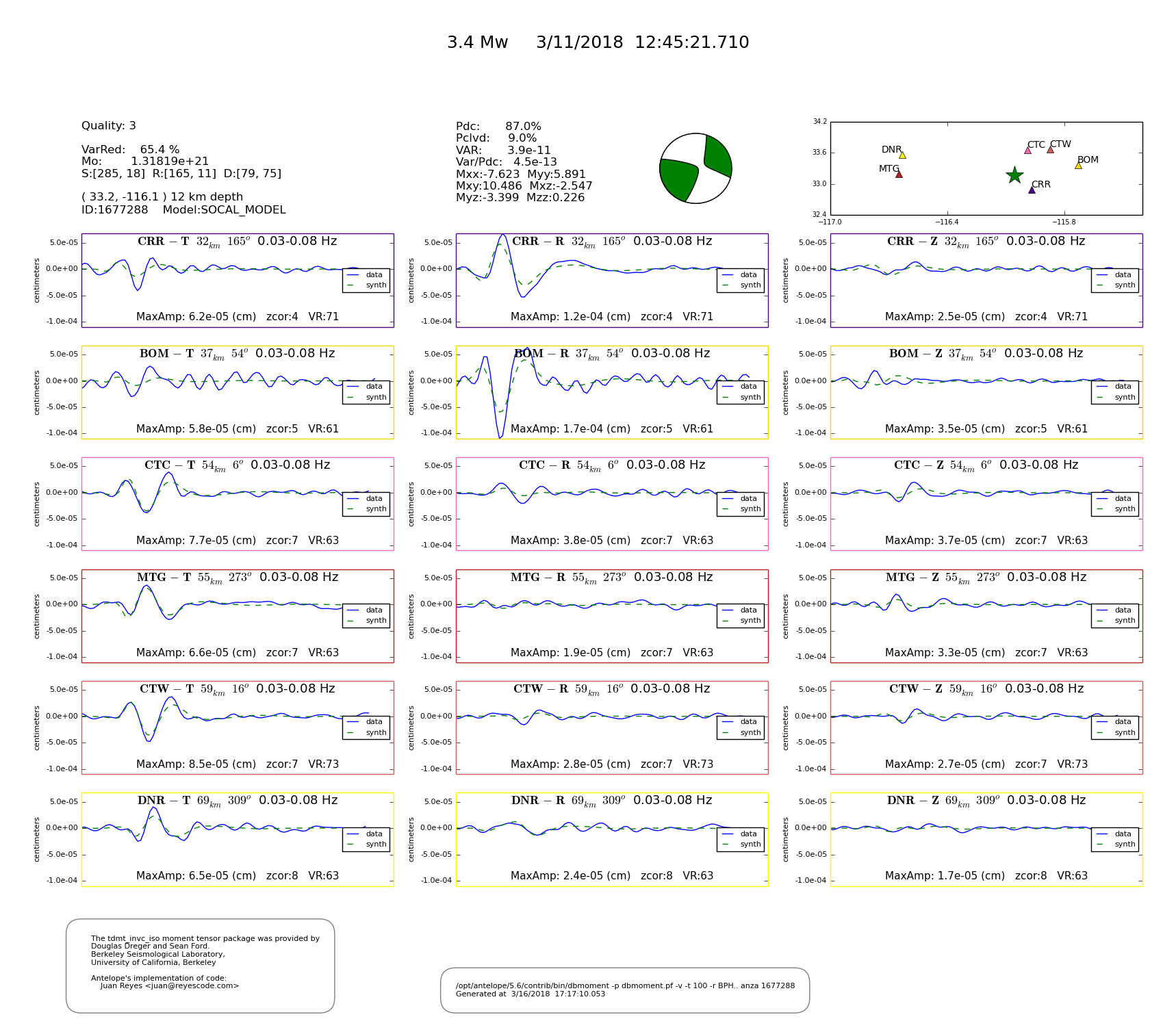
Details
Proximity to Population Centers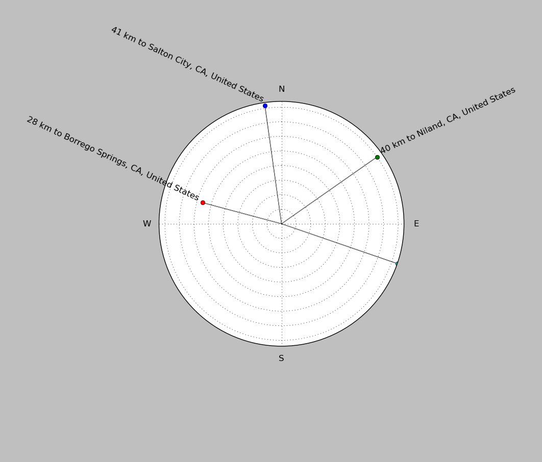
| ||||||||||||||||
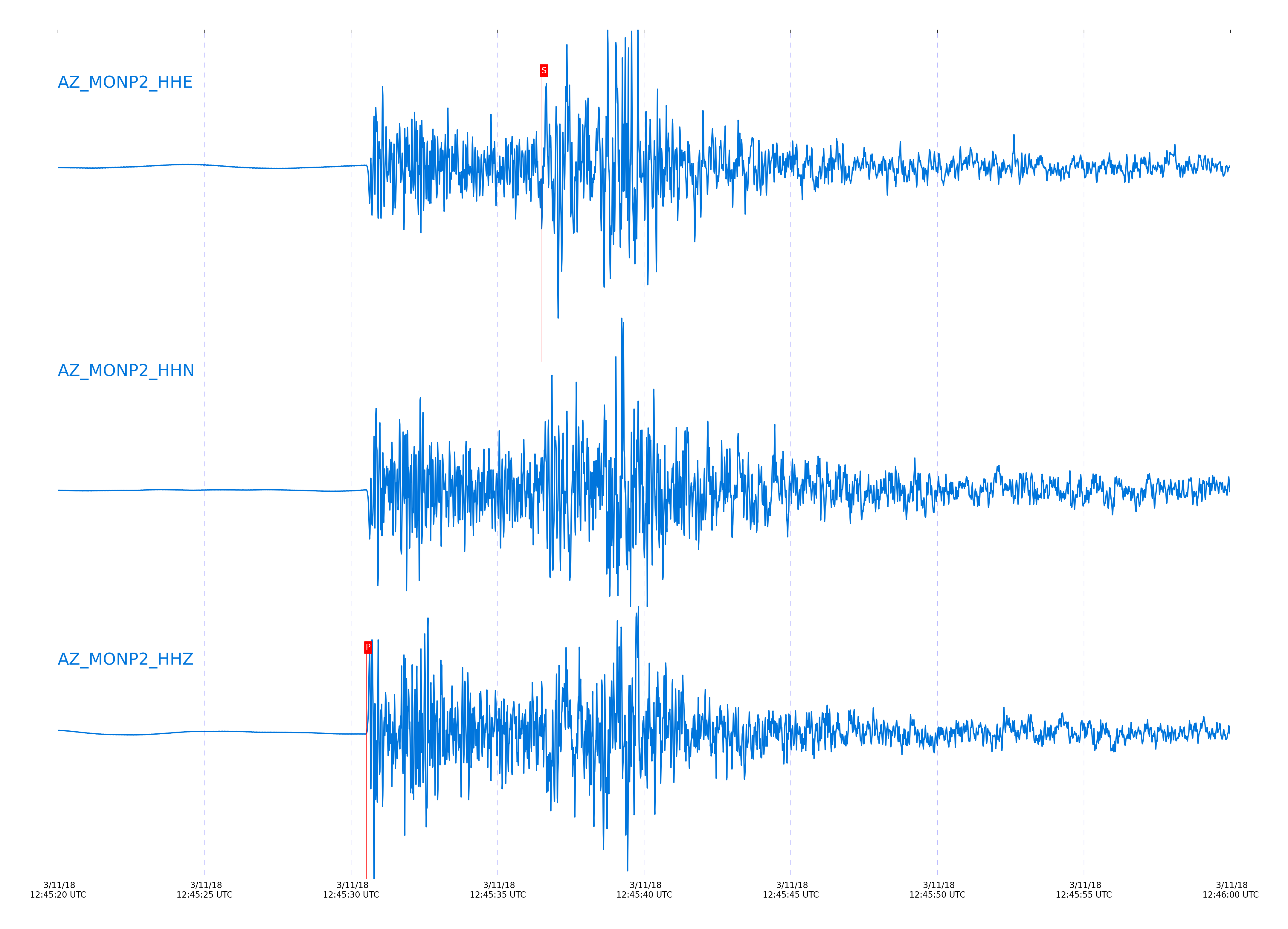
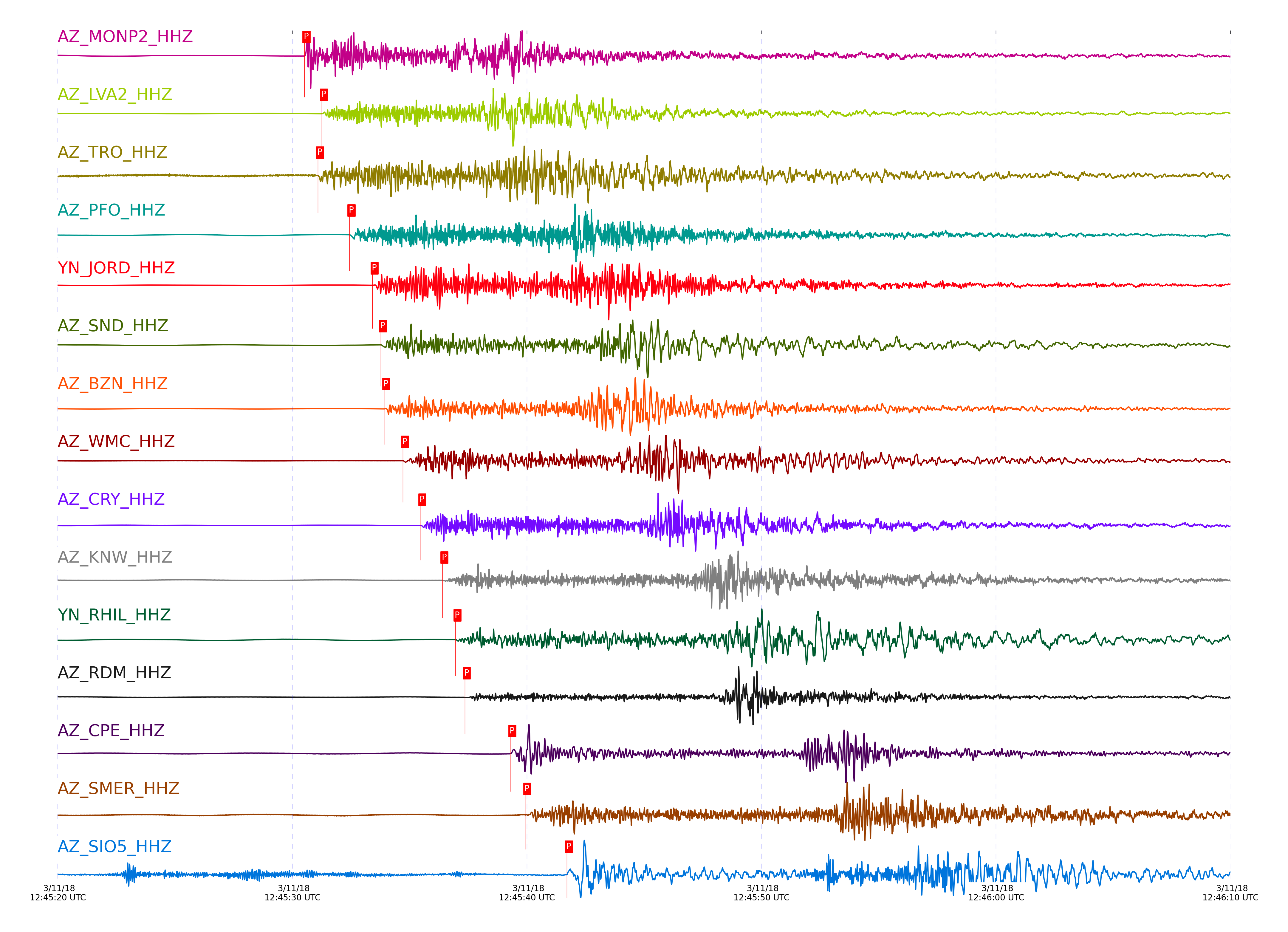
Event and active stations
|
|||||||||||||||||
Closest station with identified signal. Not filtered.
Subset of several stations close to the event. Not filtered.
| STA_CHAN | S-E Delta | S-E Azimuth | Phase | Time | Signal/Noise | Time Residual | V. Model | Auth | arid |
|---|---|---|---|---|---|---|---|---|---|
| MONP2_HHZ | 0.414° | 47.76° | P | 2018-03-11 12:45:30.5184 UTC | 982.41 | 0.367 | iasp91 | dbp:jtytell:180 | 1703328 |
| MONP2_HHE | 0.414° | 47.76° | S | 2018-03-11 12:45:36.5076 UTC | -1 | 0.198 | iasp91 | dbp:jtytell:180 | 1704341 |
| LVA2_HHZ | 0.46° | 113.13° | P | 2018-03-11 12:45:31.2631 UTC | 1901.8 | 0.311 | iasp91 | dbp:jtytell:180 | 1703330 |
| LVA2_HHE | 0.46° | 113.13° | S | 2018-03-11 12:45:38.2386 UTC | -1 | 0.543 | iasp91 | dbp:jtytell:180 | 1704343 |
| TRO_HHZ | 0.47° | 138.76° | P | 2018-03-11 12:45:31.0957 UTC | 109.03 | -0.161 | iasp91 | dbp:jtytell:180 | 1703343 |
| PFO_HHZ | 0.556° | 142.57° | P | 2018-03-11 12:45:32.438 UTC | 426.23 | -0.28 | iasp91 | dbp:jtytell:180 | 1703331 |
| JORD_HHZ | 0.578° | 121.4° | P | 2018-03-11 12:45:33.4245 UTC | 2126.8 | 0.292 | iasp91 | dbp:jtytell:180 | 1703332 |
| JORD_HHE | 0.578° | 121.4° | S | 2018-03-11 12:45:41.6192 UTC | -1 | 0.151 | iasp91 | dbp:jtytell:180 | 1704352 |
| SND_HHZ | 0.602° | 129.25° | P | 2018-03-11 12:45:33.7784 UTC | 751.67 | 0.176 | iasp91 | dbp:jtytell:180 | 1703334 |
| SND_HHN | 0.602° | 129.25° | S | 2018-03-11 12:45:42.5652 UTC | -1 | 0.282 | iasp91 | dbp:jtytell:180 | 1704353 |
| BZN_HHZ | 0.604° | 122.05° | P | 2018-03-11 12:45:33.9176 UTC | 685.51 | 0.294 | iasp91 | dbp:jtytell:180 | 1703335 |
| BZN_HHE | 0.604° | 122.05° | S | 2018-03-11 12:45:42.4116 UTC | -1 | 0.093 | iasp91 | dbp:jtytell:180 | 1704354 |
| WMC_HHZ | 0.656° | 127.83° | P | 2018-03-11 12:45:34.7178 UTC | 334.56 | 0.109 | iasp91 | dbp:jtytell:180 | 1703336 |
| WMC_HHN | 0.656° | 127.83° | S | 2018-03-11 12:45:43.7978 UTC | -1 | -0.219 | iasp91 | dbp:jtytell:180 | 1704357 |
| CRY_HHZ | 0.693° | 124.62° | P | 2018-03-11 12:45:35.4584 UTC | 640.75 | 0.161 | iasp91 | dbp:jtytell:180 | 1703337 |
| CRY_HHE | 0.693° | 124.62° | S | 2018-03-11 12:45:45.0996 UTC | -1 | -0.102 | iasp91 | dbp:jtytell:180 | 1704362 |
| KNW_HHZ | 0.772° | 134.66° | P | 2018-03-11 12:45:36.4026 UTC | 153.31 | -0.427 | iasp91 | dbp:jtytell:180 | 1703340 |
| KNW_HHN | 0.772° | 134.66° | S | 2018-03-11 12:45:47.1273 UTC | -1 | -0.727 | iasp91 | dbp:jtytell:180 | 1704369 |
| RHIL_HHZ | 0.781° | 129.94° | P | 2018-03-11 12:45:36.9558 UTC | -1 | -0.051 | iasp91 | dbp:jtytell:180 | 1704309 |
| RDM_HHZ | 0.806° | 124.62° | P | 2018-03-11 12:45:37.3554 UTC | 58.499 | -0.104 | iasp91 | dbp:jtytell:180 | 1703341 |
| RDM_HHN | 0.806° | 124.62° | S | 2018-03-11 12:45:48.3213 UTC | -1 | -0.609 | iasp91 | dbp:jtytell:180 | 1704371 |
| CPE_HHZ | 0.924° | 72° | P | 2018-03-11 12:45:39.2963 UTC | 264.22 | -0.184 | iasp91 | dbp:jtytell:180 | 1703342 |
| CPE_HHE | 0.924° | 72° | S | 2018-03-11 12:45:51.7044 UTC | -1 | -0.704 | iasp91 | dbp:jtytell:180 | 1704384 |
| SMER_HHZ | 0.975° | 106.86° | P | 2018-03-11 12:45:39.9322 UTC | 70.347 | -0.515 | iasp91 | dbp:jtytell:180 | 1703359 |
| SMER_HHE | 0.975° | 106.86° | S | 2018-03-11 12:45:53.2265 UTC | -1 | -0.86 | iasp91 | dbp:jtytell:180 | 1704387 |
| SIO5_HHZ | 1.054° | 71.47° | P | 2018-03-11 12:45:41.7062 UTC | 24.721 | -0.116 | iasp91 | dbp:jtytell:180 | 1703374 |
| SIO5_HHN | 1.054° | 71.47° | S | 2018-03-11 12:45:56.3189 UTC | -1 | -0.165 | iasp91 | dbp:jtytell:180 | 1704392 |
Click the link below to observe an interactive map of earthquakes recorded by the station deployment:
Broadband Seismic Data Collection Center (ANZA),
Institute of Geophysics & Planetary Physics
Scripps Institution of Oceanography,
University of California San Diego
Copyright © 1989 - 2014. All Rights Reserved.