
last update to page: April 05 2018 20:21:43 (UTC).
SummaryThe red marker denotes the earthquake epicenter. On Thu Apr 5th 2018 19:29:16 (UTC) the seismic network recorded an earthquake (preliminary 5.31 mw) located in Southern California. Seismic region California - Nevada Region. The epicentral distance (i.e. distance separating the location to the epicenter) to the closest station CSLB in the network is 148.5 km. If you felt the quake, the USGS would like to know. Please add your comments to the USGS page "Did you feel it?". |
Details
Proximity to Population Centers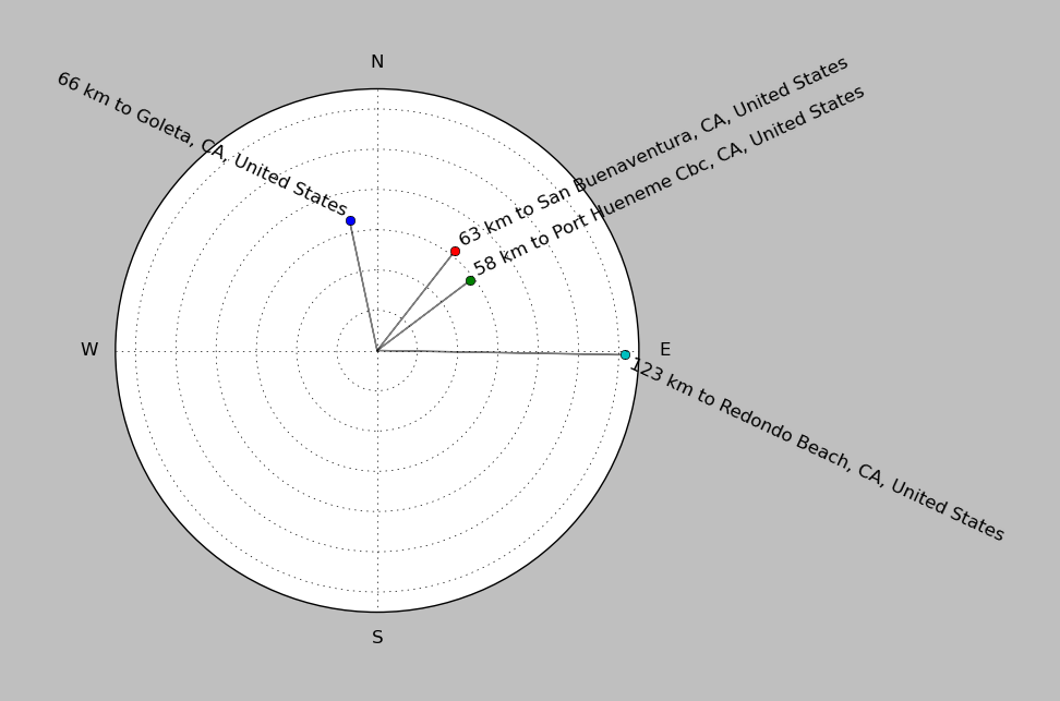
| ||||||||||||||||
Event and active stations
|
|||||||||||||||||
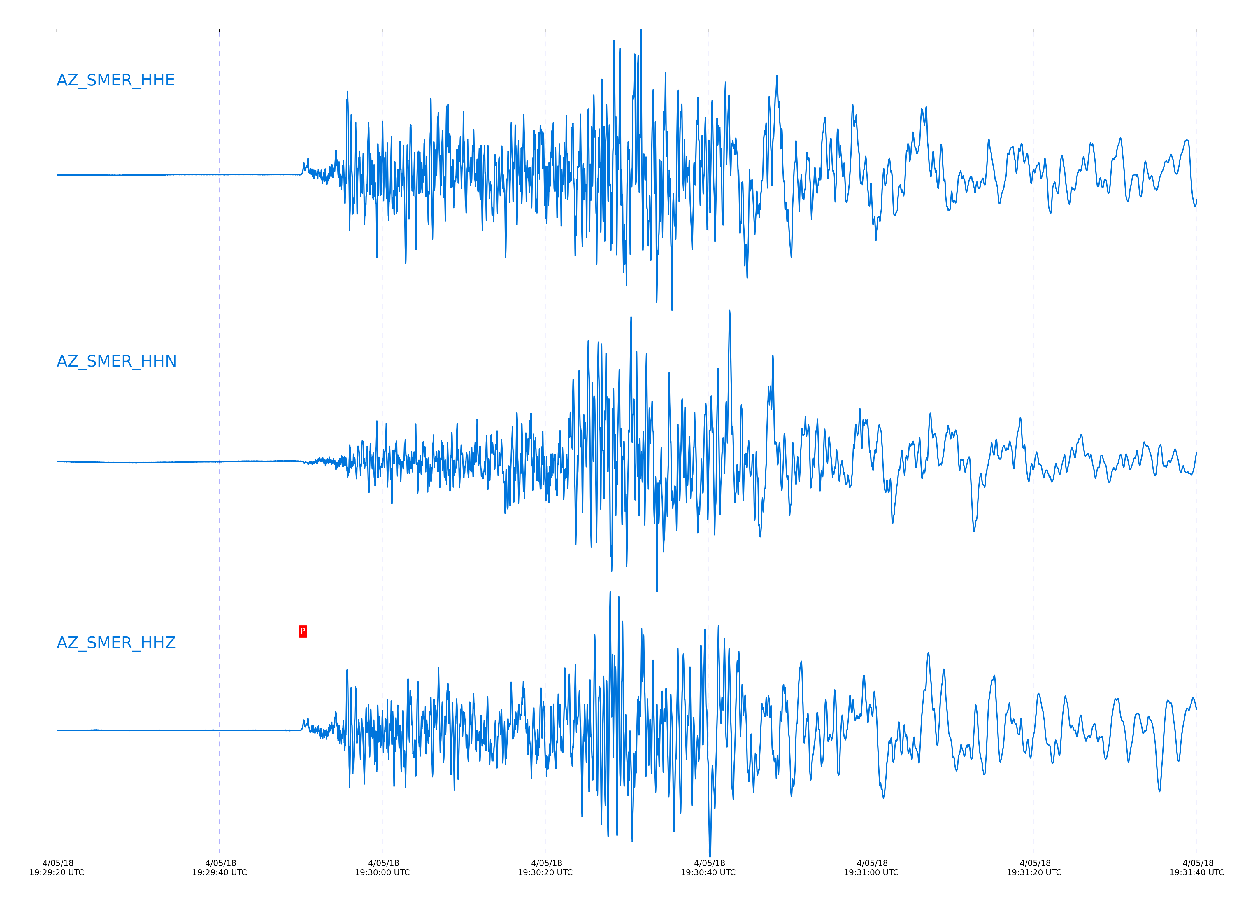
Closest station with identified signal. Not filtered.
Subset of several stations close to the event. Not filtered.
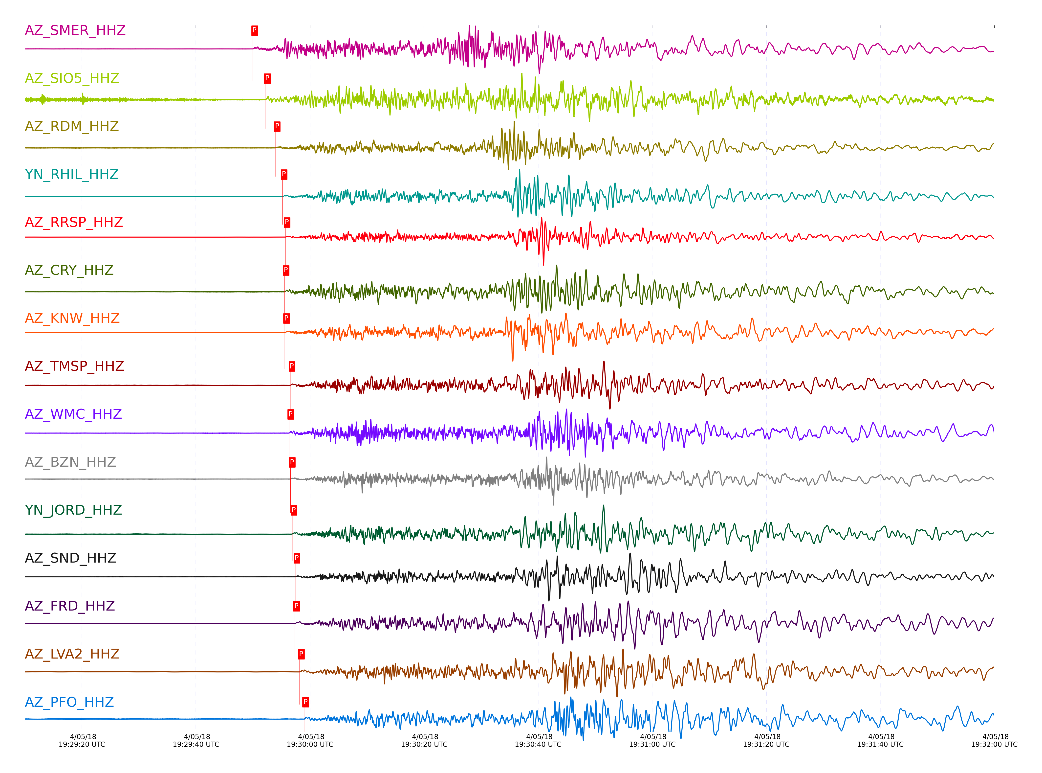
| STA_CHAN | S-E Delta | S-E Azimuth | Phase | Time | Signal/Noise | Time Residual | V. Model | Auth | arid |
|---|---|---|---|---|---|---|---|---|---|
| SMER_HHZ | 2.154° | 281.04° | Pn | 2018-04-05 19:29:50.0135 UTC | 26.686 | -1.85 | iasp91 | dbp:jtytell:180 | 1718761 |
| SIO5_HHZ | 2.292° | 296.64° | Pn | 2018-04-05 19:29:52.2504 UTC | 199.27 | -1.51 | iasp91 | dbp:jtytell:180 | 1718784 |
| RDM_HHZ | 2.395° | 275.92° | Pn | 2018-04-05 19:29:53.9758 UTC | 732.94 | -1.204 | iasp91 | dbp:jtytell:180 | 1718827 |
| RHIL_HHZ | 2.454° | 274.81° | Pn | 2018-04-05 19:29:55.1762 UTC | -1 | -0.82 | iasp91 | dbp:jtytell:180 | 1718897 |
| RRSP_HHZ | 2.483° | 275.27° | Pn | 2018-04-05 19:29:55.6846 UTC | -1 | -0.701 | iasp91 | dbp:jtytell:180 | 1718902 |
| CRY_HHZ | 2.494° | 277.24° | Pn | 2018-04-05 19:29:55.5137 UTC | -1 | -1.025 | iasp91 | dbp:jtytell:180 | 1718900 |
| KNW_HHZ | 2.5° | 273.81° | Pn | 2018-04-05 19:29:55.5973 UTC | 1130 | -1.034 | iasp91 | dbp:jtytell:180 | 1718832 |
| TMSP_HHZ | 2.534° | 275.93° | Pn | 2018-04-05 19:29:56.5553 UTC | -1 | -0.54 | iasp91 | dbp:jtytell:180 | 1718904 |
| WMC_HHZ | 2.544° | 276.94° | Pn | 2018-04-05 19:29:56.3384 UTC | 868.79 | -0.898 | iasp91 | dbp:jtytell:180 | 1718834 |
| BZN_HHZ | 2.562° | 278.75° | Pn | 2018-04-05 19:29:56.5942 UTC | 27.129 | -0.884 | iasp91 | dbp:jtytell:180 | 1718773 |
| JORD_HHZ | 2.583° | 279.12° | Pn | 2018-04-05 19:29:56.8995 UTC | 1218.4 | -0.869 | iasp91 | dbp:jtytell:180 | 1718794 |
| SND_HHZ | 2.598° | 277.31° | Pn | 2018-04-05 19:29:57.4146 UTC | 836.89 | -0.562 | iasp91 | dbp:jtytell:180 | 1718841 |
| FRD_HHZ | 2.615° | 278.54° | Pn | 2018-04-05 19:29:57.3652 UTC | 720.29 | -0.841 | iasp91 | dbp:jtytell:180 | 1718796 |
| LVA2_HHZ | 2.673° | 281.48° | Pn | 2018-04-05 19:29:58.1971 UTC | 64.547 | -0.812 | iasp91 | dbp:jtytell:180 | 1718777 |
| PFO_HHZ | 2.718° | 275.8° | Pn | 2018-04-05 19:29:58.9729 UTC | 710.33 | -0.657 | iasp91 | dbp:jtytell:180 | 1718844 |
| TRO_HHZ | 2.757° | 277.59° | Pn | 2018-04-05 19:29:59.6399 UTC | 796.33 | -0.515 | iasp91 | dbp:jtytell:180 | 1718846 |
| MONP2_HHZ | 2.911° | 289.99° | Pn | 2018-04-05 19:30:01.3284 UTC | 106.34 | -0.946 | iasp91 | dbp:jtytell:180 | 1718806 |
Click the link below to observe an interactive map of earthquakes recorded by the station deployment:
Broadband Seismic Data Collection Center (ANZA),
Institute of Geophysics & Planetary Physics
Scripps Institution of Oceanography,
University of California San Diego
Copyright © 1989 - 2014. All Rights Reserved.