
last update to page: April 23 2018 18:58:19 (UTC).
SummaryThe red marker denotes the earthquake epicenter. On Mon Apr 23rd 2018 00:46:08 (UTC) the seismic network recorded an earthquake (preliminary 3.87 mw) located in Southern California. Seismic region California - Nevada Region. The epicentral distance (i.e. distance separating the location to the epicenter) to the closest station PFO in the network is 36.7 km. If you felt the quake, the USGS would like to know. Please add your comments to the USGS page "Did you feel it?". |
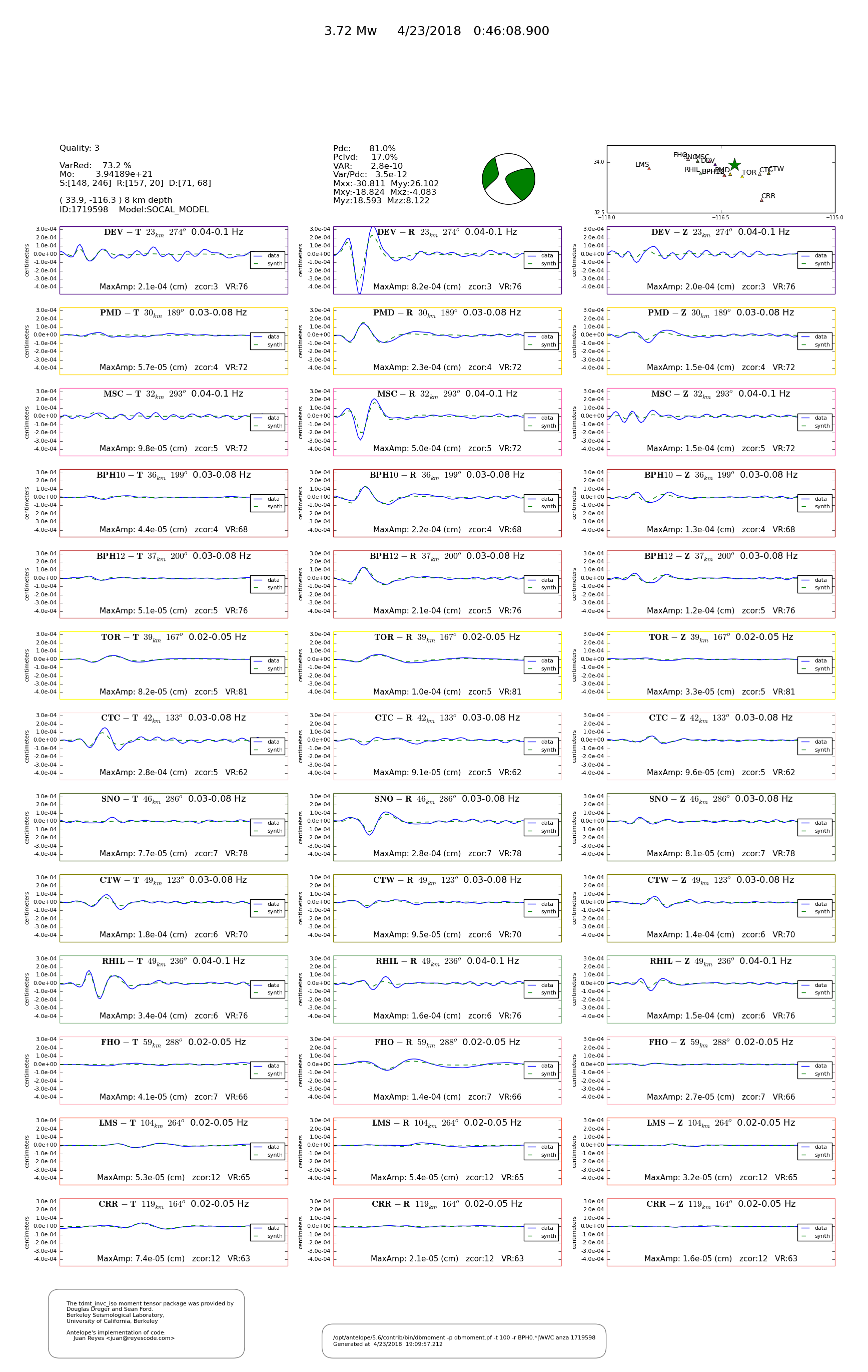
Details
Proximity to Population Centers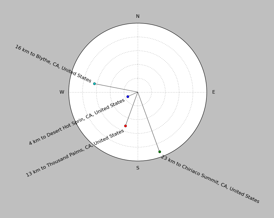
| ||||||||||||||||
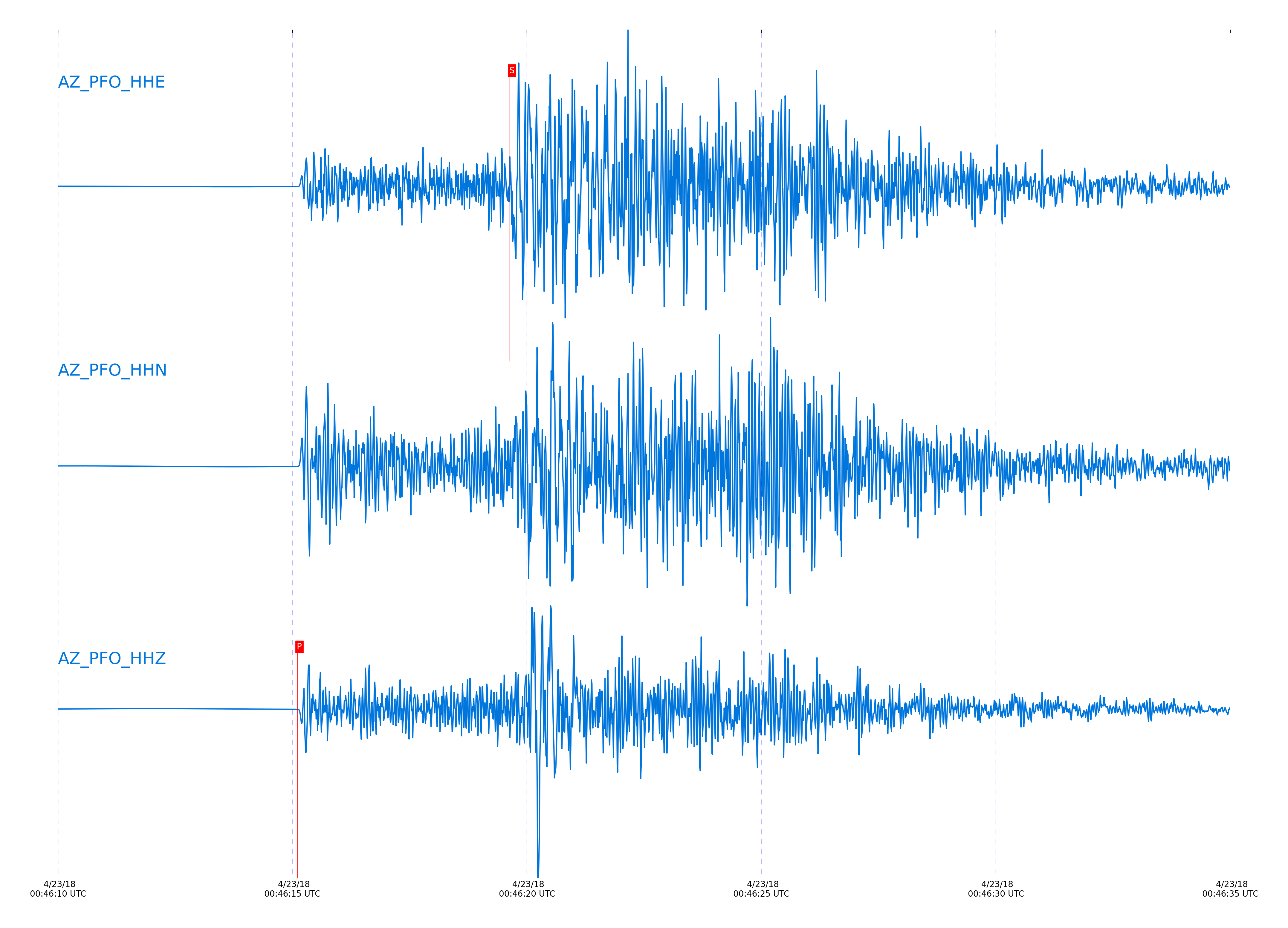
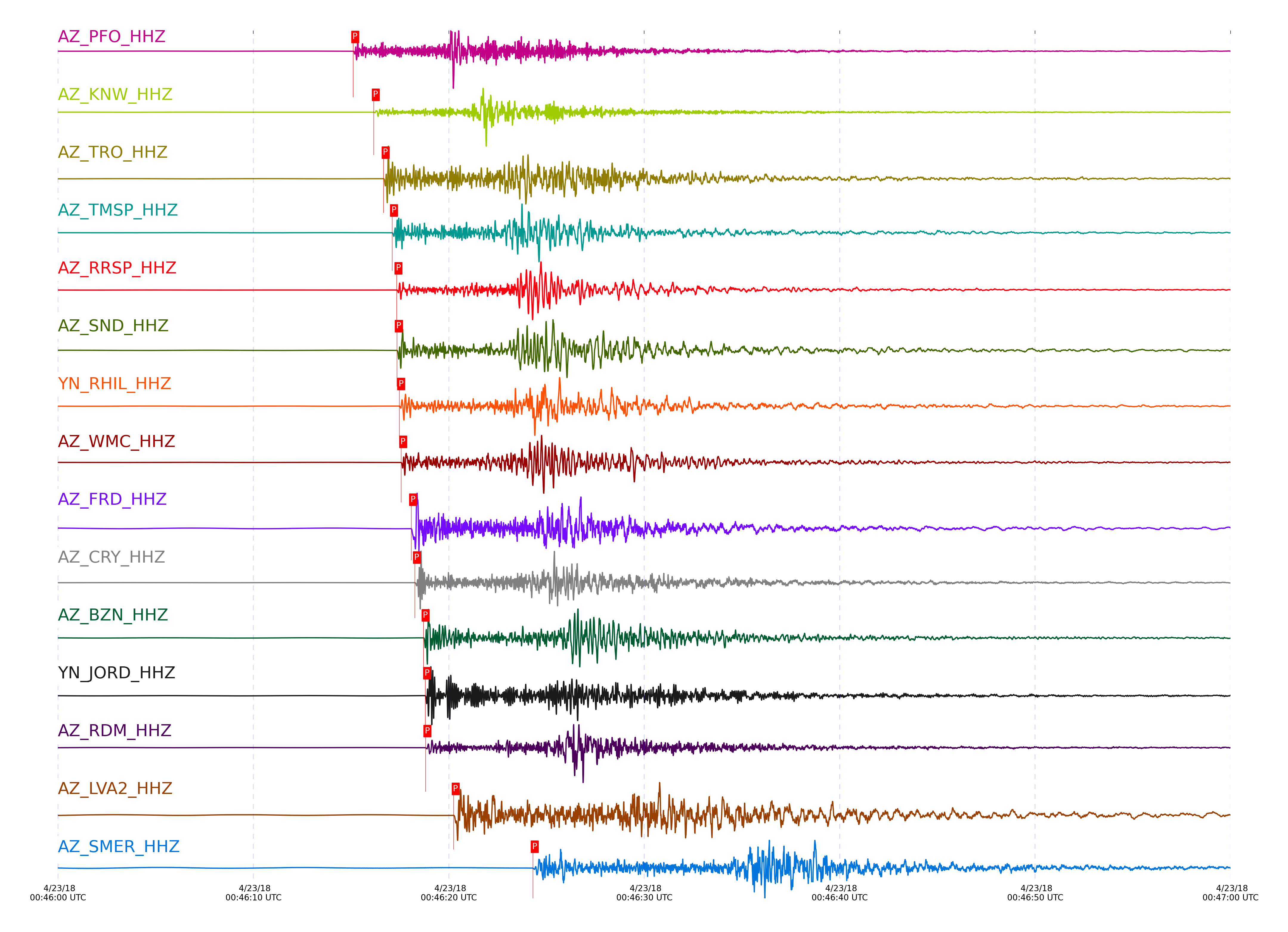
Event and active stations
|
|||||||||||||||||
Closest station with identified signal. Not filtered.
Subset of several stations close to the event. Not filtered.
| STA_CHAN | S-E Delta | S-E Azimuth | Phase | Time | Signal/Noise | Time Residual | V. Model | Auth | arid |
|---|---|---|---|---|---|---|---|---|---|
| PFO_HHZ | 0.33° | 20.27° | Pg | 2018-04-23 00:46:15.1084 UTC | 3296 | -0.27 | iasp91 | dbp:jtytell:181 | 1733927 |
| PFO_HHE | 0.33° | 20.27° | Sg | 2018-04-23 00:46:19.6364 UTC | -1 | -0.456 | iasp91 | dbp:jtytell:181 | 1734918 |
| KNW_HHZ | 0.385° | 57.34° | Pg | 2018-04-23 00:46:16.1631 UTC | 830.9 | -0.246 | iasp91 | dbp:jtytell:181 | 1733931 |
| KNW_HHE | 0.385° | 57.34° | Sg | 2018-04-23 00:46:21.2964 UTC | -1 | -0.574 | iasp91 | dbp:jtytell:181 | 1734925 |
| TRO_HHZ | 0.407° | 12.25° | Pg | 2018-04-23 00:46:16.6644 UTC | 573.88 | -0.166 | iasp91 | dbp:jtytell:181 | 1733933 |
| GVAR1_HHE | 0.409° | 51.36° | Sg | 2018-04-23 00:46:22.081 UTC | -1 | -0.58 | iasp91 | dbp:jtytell:181 | 1734930 |
| TMSP_HHZ | 0.425° | 44.59° | Pg | 2018-04-23 00:46:17.1014 UTC | -1 | -0.062 | iasp91 | dbp:jtytell:181 | 1734866 |
| TMSP_HHN | 0.425° | 44.59° | Sg | 2018-04-23 00:46:23.1957 UTC | -1 | 0.024 | iasp91 | dbp:jtytell:181 | 1734932 |
| RRSP_HHZ | 0.439° | 52.06° | Pg | 2018-04-23 00:46:17.3297 UTC | -1 | -0.116 | iasp91 | dbp:jtytell:181 | 1734870 |
| RRSP_HHN | 0.439° | 52.06° | Sg | 2018-04-23 00:46:23.4628 UTC | -1 | -0.195 | iasp91 | dbp:jtytell:181 | 1734936 |
| SND_HHZ | 0.441° | 33.19° | Pg | 2018-04-23 00:46:17.3484 UTC | 1795.3 | -0.135 | iasp91 | dbp:jtytell:181 | 1733936 |
| SND_HHN | 0.441° | 33.19° | Sg | 2018-04-23 00:46:23.5227 UTC | -1 | -0.2 | iasp91 | dbp:jtytell:181 | 1734940 |
| RHIL_HHZ | 0.448° | 56.32° | Pg | 2018-04-23 00:46:17.4644 UTC | -1 | -0.149 | iasp91 | dbp:jtytell:181 | 1734873 |
| RHIL_HHN | 0.448° | 56.32° | Sg | 2018-04-23 00:46:23.6603 UTC | -1 | -0.286 | iasp91 | dbp:jtytell:181 | 1734943 |
| WMC_HHZ | 0.455° | 40.1° | Pg | 2018-04-23 00:46:17.5684 UTC | 397.95 | -0.167 | iasp91 | dbp:jtytell:181 | 1733942 |
| WMC_HHN | 0.455° | 40.1° | Sg | 2018-04-23 00:46:23.7371 UTC | -1 | -0.42 | iasp91 | dbp:jtytell:181 | 1734944 |
| FRD_HHZ | 0.486° | 28.62° | Pg | 2018-04-23 00:46:18.0784 UTC | 1293.4 | -0.247 | iasp91 | dbp:jtytell:181 | 1733944 |
| FRD_HHN | 0.486° | 28.62° | Sg | 2018-04-23 00:46:24.6459 UTC | -1 | -0.53 | iasp91 | dbp:jtytell:181 | 1734948 |
| CRY_HHZ | 0.496° | 44.07° | Pg | 2018-04-23 00:46:18.2684 UTC | 1939.2 | -0.244 | iasp91 | dbp:jtytell:181 | 1733946 |
| CRY_HHE | 0.496° | 44.07° | Sg | 2018-04-23 00:46:25.0529 UTC | -1 | -0.446 | iasp91 | dbp:jtytell:181 | 1734950 |
| BZN_HHZ | 0.517° | 33.68° | Pg | 2018-04-23 00:46:18.7084 UTC | 1218.4 | -0.199 | iasp91 | dbp:jtytell:181 | 1733948 |
| BZN_HHN | 0.517° | 33.68° | Sg | 2018-04-23 00:46:25.6223 UTC | -1 | -0.558 | iasp91 | dbp:jtytell:181 | 1734951 |
| JORD_HHZ | 0.523° | 30.85° | Pg | 2018-04-23 00:46:18.7945 UTC | 2713 | -0.237 | iasp91 | dbp:jtytell:181 | 1733950 |
| JORD_HHE | 0.523° | 30.85° | Sg | 2018-04-23 00:46:25.9735 UTC | -1 | -0.42 | iasp91 | dbp:jtytell:181 | 1734952 |
| RDM_HHZ | 0.525° | 56.21° | Pg | 2018-04-23 00:46:18.8084 UTC | 230.41 | -0.262 | iasp91 | dbp:jtytell:181 | 1733952 |
| RDM_HHE | 0.525° | 56.21° | Sg | 2018-04-23 00:46:25.9288 UTC | -1 | -0.531 | iasp91 | dbp:jtytell:181 | 1734953 |
| LVA2_HHZ | 0.603° | 19.26° | Pg | 2018-04-23 00:46:20.2531 UTC | 1809.4 | -0.3 | iasp91 | dbp:jtytell:181 | 1733954 |
| SMER_HHZ | 0.845° | 56.51° | Pg | 2018-04-23 00:46:24.2984 UTC | 224.7 | -0.852 | iasp91 | dbp:jtytell:181 | 1733971 |
| SMER_HHN | 0.845° | 56.51° | Sg | 2018-04-23 00:46:35.268 UTC | -1 | -1.683 | iasp91 | dbp:jtytell:181 | 1734968 |
| MONP2_HHZ | 1.032° | 4.64° | Pg | 2018-04-23 00:46:27.7884 UTC | 1069.4 | -0.943 | iasp91 | dbp:jtytell:181 | 1733972 |
| MONP2_HHE | 1.032° | 4.64° | Sg | 2018-04-23 00:46:41.4262 UTC | -1 | -1.706 | iasp91 | dbp:jtytell:181 | 1734974 |
| CPE_HHZ | 1.222° | 32.15° | Pb | 2018-04-23 00:46:30.4692 UTC | 273.04 | -1.751 | iasp91 | dbp:jtytell:181 | 1733973 |
| CPE_HHN | 1.222° | 32.15° | Sb | 2018-04-23 00:46:46.2524 UTC | -1 | -2.982 | iasp91 | dbp:jtytell:181 | 1734979 |
| SIO5_HHN | 1.329° | 35.4° | Sb | 2018-04-23 00:46:50.0566 UTC | -1 | -2.359 | iasp91 | dbp:jtytell:181 | 1734984 |
Click the link below to observe an interactive map of earthquakes recorded by the station deployment:
Broadband Seismic Data Collection Center (ANZA),
Institute of Geophysics & Planetary Physics
Scripps Institution of Oceanography,
University of California San Diego
Copyright © 1989 - 2014. All Rights Reserved.