
last update to page: June 06 2018 17:48:20 (UTC).
SummaryThe red marker denotes the earthquake epicenter. On Thu Apr 26th 2018 01:36:00 (UTC) the seismic network recorded an earthquake (preliminary 3.94 mw) located in Southern California. Seismic region California - Nevada Region. The epicentral distance (i.e. distance separating the location to the epicenter) to the closest station BVDA2 in the network is 8.7 km. If you felt the quake, the USGS would like to know. Please add your comments to the USGS page "Did you feel it?". |
Details
Proximity to Population Centers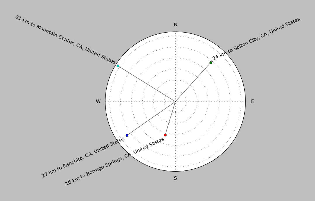
| ||||||||||||||||
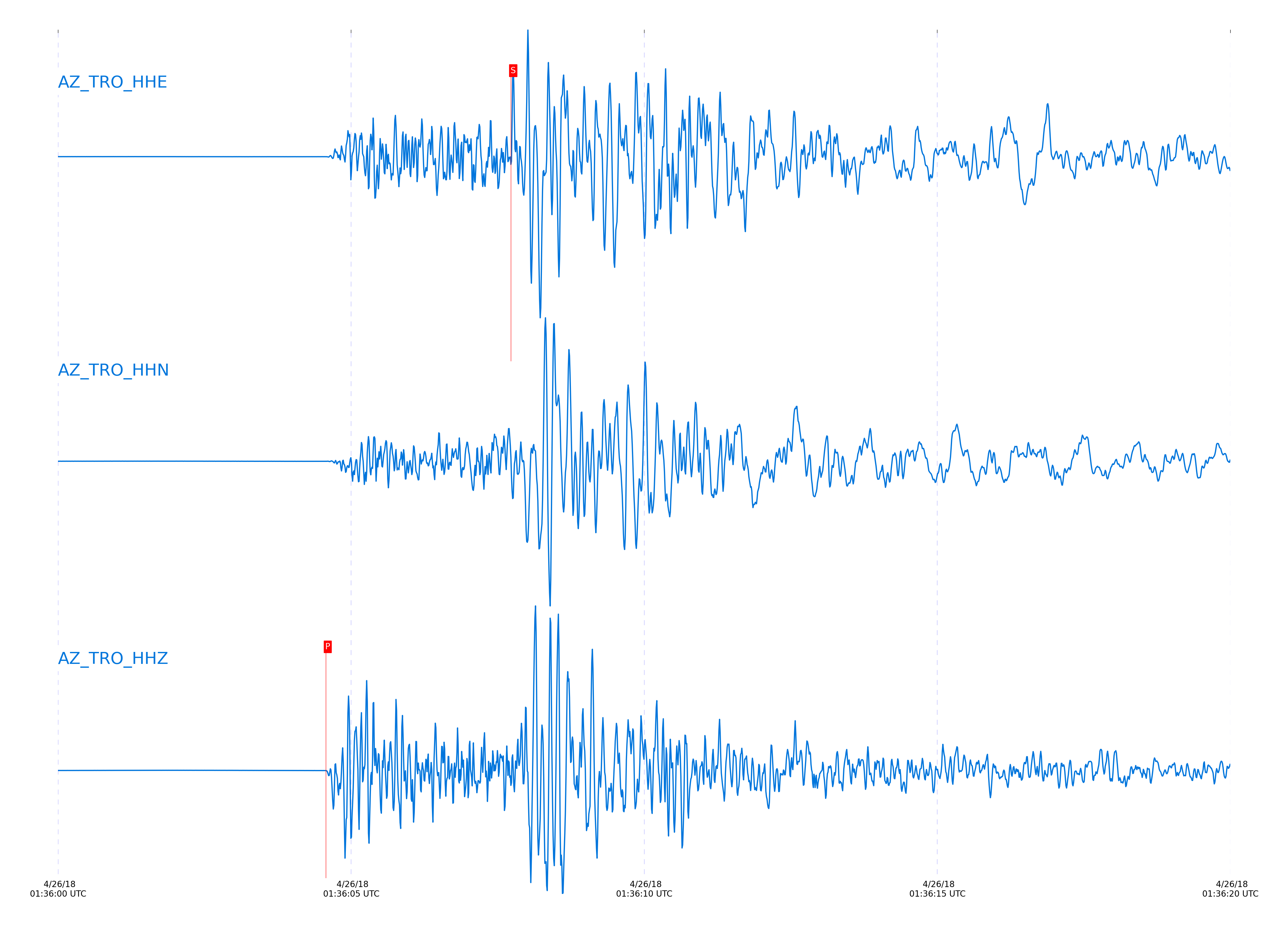
Event and active stations
|
|||||||||||||||||
Closest station with identified signal. Not filtered.
Subset of several stations close to the event. Not filtered.
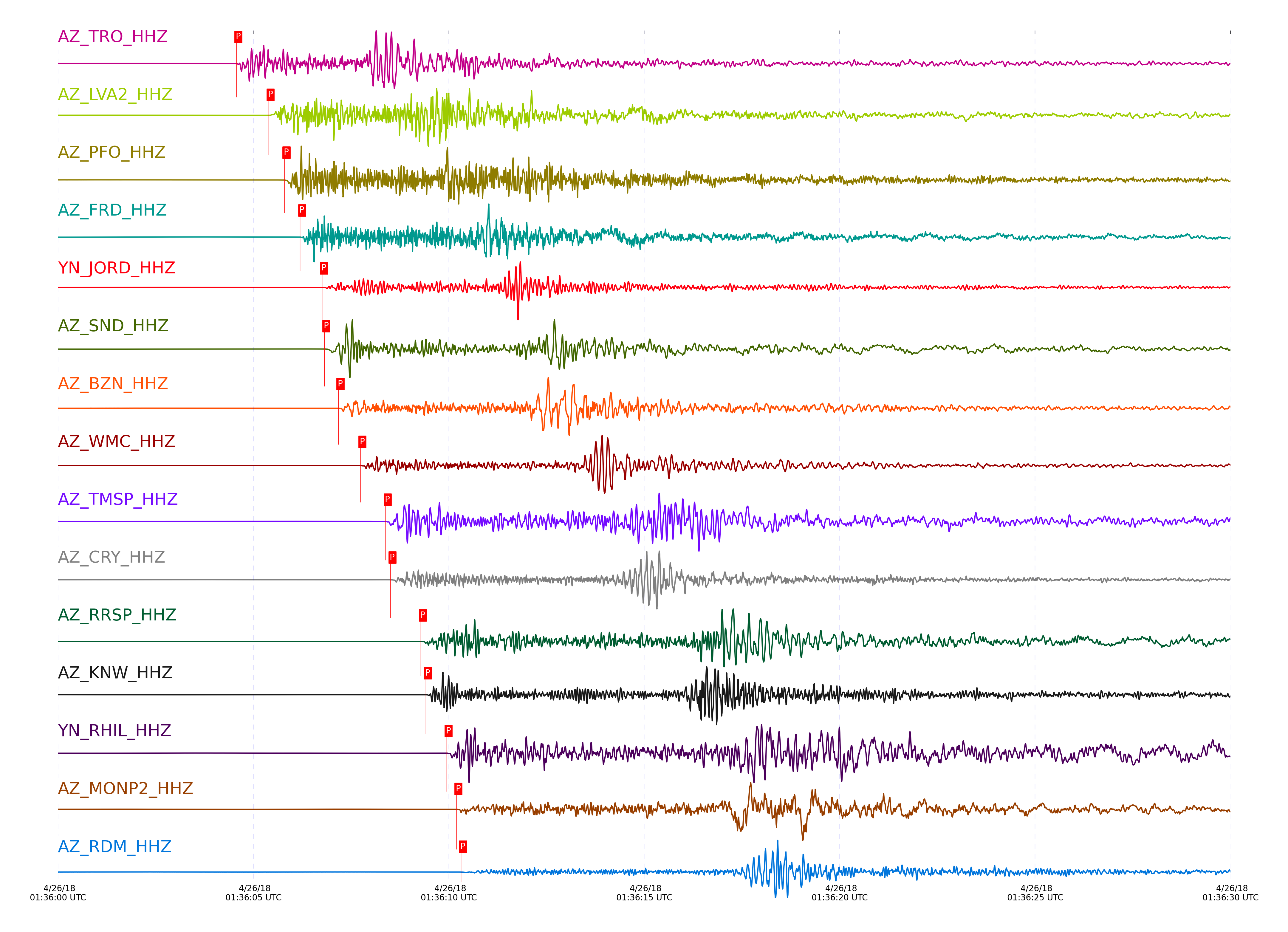
| STA_CHAN | S-E Delta | S-E Azimuth | Phase | Time | Signal/Noise | Time Residual | V. Model | Auth | arid |
|---|---|---|---|---|---|---|---|---|---|
| TRO_HHZ | 0.179° | 143.47° | Pg | 2018-04-26 01:36:04.5684 UTC | 3698 | -0.185 | iasp91 | dbp:jtytell:181 | 1737129 |
| TRO_HHE | 0.179° | 143.47° | Sg | 2018-04-26 01:36:07.7291 UTC | -1 | -0.151 | iasp91 | dbp:jtytell:181 | 1738191 |
| LVA2_HHZ | 0.222° | 82.64° | Pg | 2018-04-26 01:36:05.3931 UTC | 10016 | -0.045 | iasp91 | dbp:jtytell:181 | 1737131 |
| LVA2_HHN | 0.222° | 82.64° | Sg | 2018-04-26 01:36:09.1865 UTC | -1 | 0.164 | iasp91 | dbp:jtytell:181 | 1738195 |
| PFO_HHZ | 0.268° | 149.88° | Pg | 2018-04-26 01:36:05.7984 UTC | 2360.7 | -0.433 | iasp91 | dbp:jtytell:181 | 1737132 |
| PFO_HHE | 0.268° | 149.88° | Sg | 2018-04-26 01:36:09.8684 UTC | -1 | -0.477 | iasp91 | dbp:jtytell:181 | 1738206 |
| FRD_HHZ | 0.278° | 114.31° | Pg | 2018-04-26 01:36:06.1984 UTC | 4831 | -0.214 | iasp91 | dbp:jtytell:181 | 1737134 |
| FRD_HHN | 0.278° | 114.31° | Sg | 2018-04-26 01:36:10.521 UTC | -1 | -0.129 | iasp91 | dbp:jtytell:181 | 1738207 |
| JORD_HHZ | 0.304° | 107.63° | Pg | 2018-04-26 01:36:06.7595 UTC | 9135.8 | -0.1 | iasp91 | dbp:jtytell:181 | 1737138 |
| JORD_HHN | 0.304° | 107.63° | Sg | 2018-04-26 01:36:11.3274 UTC | -1 | -0.078 | iasp91 | dbp:jtytell:181 | 1738214 |
| SND_HHZ | 0.314° | 123.18° | Pg | 2018-04-26 01:36:06.8184 UTC | 6711 | -0.22 | iasp91 | dbp:jtytell:181 | 1737140 |
| SND_HHE | 0.314° | 123.18° | Sg | 2018-04-26 01:36:11.8213 UTC | -1 | 0.109 | iasp91 | dbp:jtytell:181 | 1738212 |
| BZN_HHZ | 0.327° | 109.87° | Pg | 2018-04-26 01:36:07.1784 UTC | 410.96 | -0.101 | iasp91 | dbp:jtytell:181 | 1737142 |
| BZN_HHE | 0.327° | 109.87° | Sg | 2018-04-26 01:36:11.9568 UTC | -1 | -0.167 | iasp91 | dbp:jtytell:181 | 1738213 |
| WMC_HHZ | 0.369° | 121.6° | Pg | 2018-04-26 01:36:07.7407 UTC | 608.82 | -0.287 | iasp91 | dbp:jtytell:181 | 1737144 |
| WMC_HHE | 0.369° | 121.6° | Sg | 2018-04-26 01:36:13.3673 UTC | -1 | -0.051 | iasp91 | dbp:jtytell:181 | 1738216 |
| TMSP_HHZ | 0.399° | 126.79° | Pg | 2018-04-26 01:36:08.3855 UTC | -1 | -0.186 | iasp91 | dbp:jtytell:181 | 1738137 |
| TMSP_HHN | 0.399° | 126.79° | Sg | 2018-04-26 01:36:14.6048 UTC | -1 | 0.24 | iasp91 | dbp:jtytell:181 | 1738268 |
| CRY_HHZ | 0.411° | 116.77° | Pg | 2018-04-26 01:36:08.5095 UTC | 1176.8 | -0.274 | iasp91 | dbp:jtytell:181 | 1737146 |
| CRY_HHN | 0.411° | 116.77° | Sg | 2018-04-26 01:36:14.1821 UTC | -1 | -0.555 | iasp91 | dbp:jtytell:181 | 1738269 |
| RRSP_HHZ | 0.457° | 126.34° | Pg | 2018-04-26 01:36:09.2882 UTC | -1 | -0.352 | iasp91 | dbp:jtytell:181 | 1738141 |
| RRSP_HHN | 0.457° | 126.34° | Sg | 2018-04-26 01:36:16.1258 UTC | -1 | -0.112 | iasp91 | dbp:jtytell:181 | 1738274 |
| KNW_HHZ | 0.48° | 134.02° | Pg | 2018-04-26 01:36:09.4131 UTC | 7753.7 | -0.651 | iasp91 | dbp:jtytell:181 | 1737152 |
| RHIL_HHZ | 0.492° | 126.53° | Pg | 2018-04-26 01:36:09.9453 UTC | -1 | -0.328 | iasp91 | dbp:jtytell:181 | 1738146 |
| RHIL_HHN | 0.492° | 126.53° | Sg | 2018-04-26 01:36:17.0272 UTC | -1 | -0.316 | iasp91 | dbp:jtytell:181 | 1738280 |
| MONP2_HHZ | 0.499° | 11.99° | Pg | 2018-04-26 01:36:10.1984 UTC | 939.25 | -0.207 | iasp91 | dbp:jtytell:181 | 1737154 |
| MONP2_HHN | 0.499° | 11.99° | Sg | 2018-04-26 01:36:17.1392 UTC | -1 | -0.433 | iasp91 | dbp:jtytell:181 | 1738281 |
| RDM_HHZ | 0.522° | 118.49° | Pg | 2018-04-26 01:36:10.3147 UTC | 173.68 | -0.529 | iasp91 | dbp:jtytell:181 | 1737156 |
| RDM_HHN | 0.522° | 118.49° | Sg | 2018-04-26 01:36:17.8202 UTC | -1 | -0.511 | iasp91 | dbp:jtytell:181 | 1738283 |
| SMER_HHZ | 0.732° | 95.87° | Pg | 2018-04-26 01:36:13.7684 UTC | 384.92 | -1.037 | iasp91 | dbp:jtytell:181 | 1737173 |
| SMER_HHE | 0.732° | 95.87° | Sg | 2018-04-26 01:36:23.7197 UTC | -1 | -1.446 | iasp91 | dbp:jtytell:181 | 1738289 |
| CPE_HHZ | 0.835° | 53.78° | Pg | 2018-04-26 01:36:15.4944 UTC | 272.42 | -1.253 | iasp91 | dbp:jtytell:181 | 1737175 |
| CPE_HHN | 0.835° | 53.78° | Sg | 2018-04-26 01:36:26.4999 UTC | -1 | -2.015 | iasp91 | dbp:jtytell:181 | 1738294 |
| SIO5_HHZ | 0.962° | 55.67° | Pb | 2018-04-26 01:36:18.1131 UTC | 31.635 | -0.891 | iasp91 | dbp:jtytell:181 | 1737188 |
| SIO5_HHN | 0.962° | 55.67° | Sb | 2018-04-26 01:36:30.8288 UTC | -1 | -1.63 | iasp91 | dbp:jtytell:181 | 1738302 |
Click the link below to observe an interactive map of earthquakes recorded by the station deployment:
Broadband Seismic Data Collection Center (ANZA),
Institute of Geophysics & Planetary Physics
Scripps Institution of Oceanography,
University of California San Diego
Copyright © 1989 - 2014. All Rights Reserved.