
last update to page: May 21 2018 20:11:09 (UTC).
SummaryThe red marker denotes the earthquake epicenter. On Sat May 19th 2018 19:26:50 (UTC) the seismic network recorded an earthquake (preliminary 3.45 ml) located in Southern California. Seismic region California - Nevada Region. The epicentral distance (i.e. distance separating the location to the epicenter) to the closest station CRY in the network is 10.1 km. If you felt the quake, the USGS would like to know. Please add your comments to the USGS page "Did you feel it?". |
Details
Proximity to Population Centers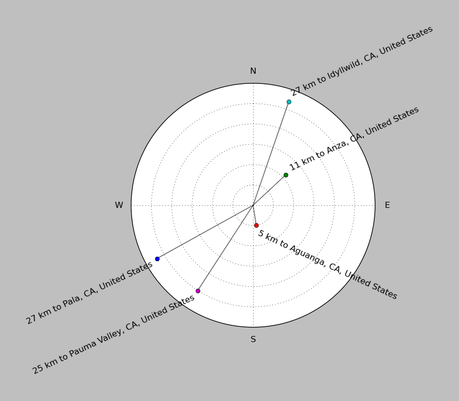
| ||||||||||||||||
Event and active stations
|
|||||||||||||||||
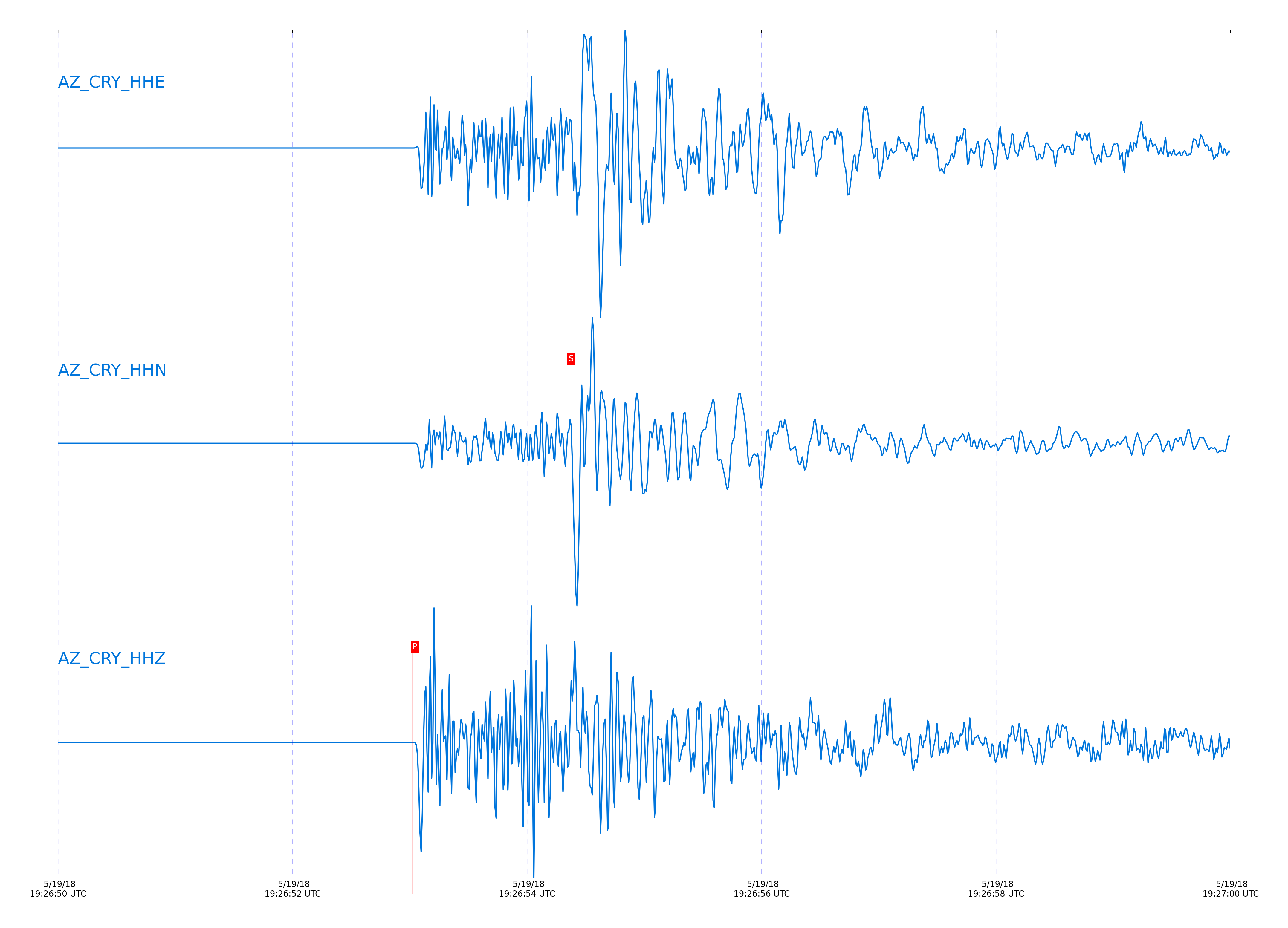
Closest station with identified signal. Not filtered.
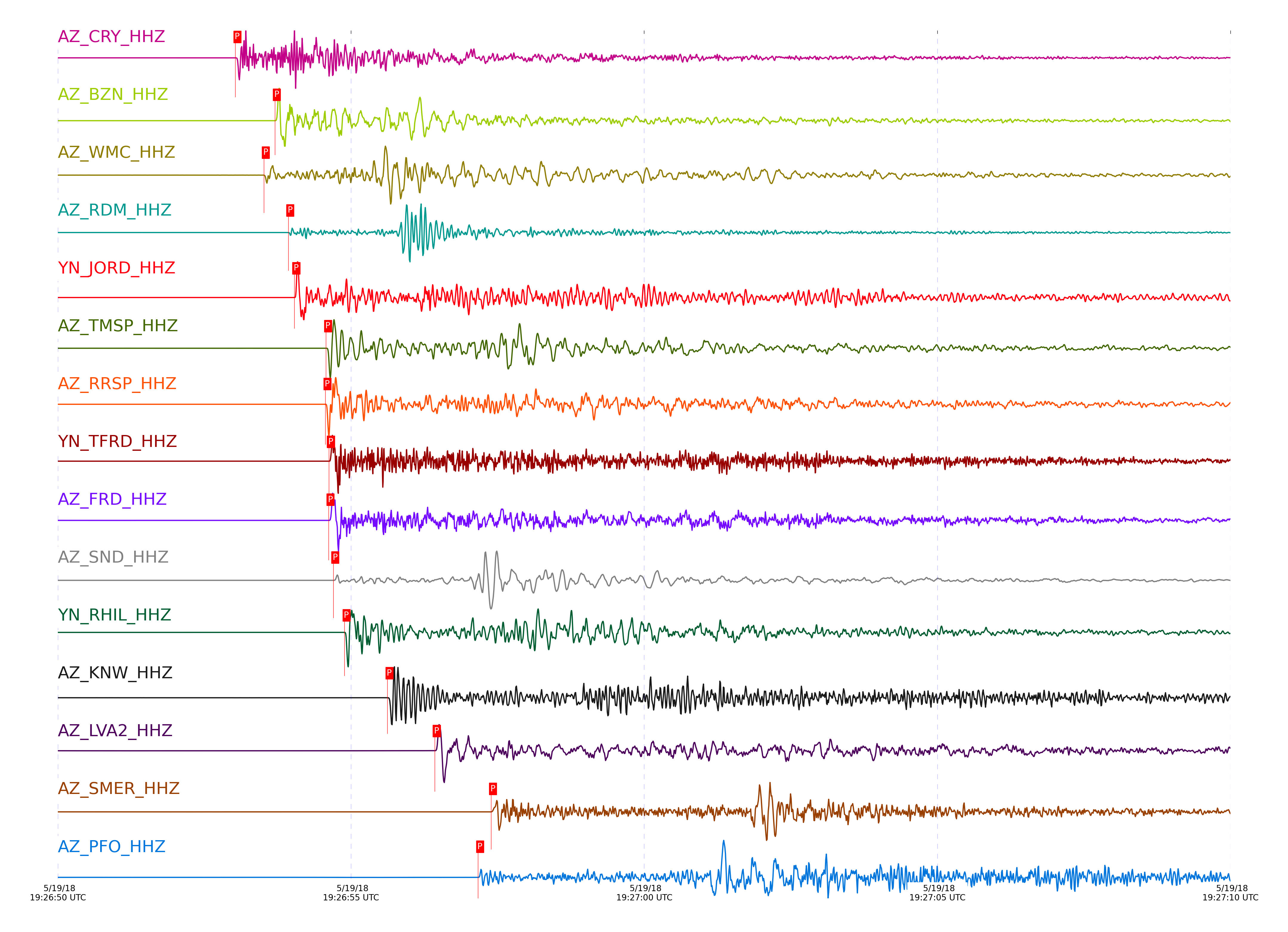
Subset of several stations close to the event. Not filtered.
| STA_CHAN | S-E Delta | S-E Azimuth | Phase | Time | Signal/Noise | Time Residual | V. Model | Auth | arid |
|---|---|---|---|---|---|---|---|---|---|
| CRY_HHZ | 0.091° | 220.78° | P | 2018-05-19 19:26:53.0284 UTC | 13794 | -0.096 | iasp91 | dbp:jtytell:181 | 1761091 |
| CRY_HHN | 0.091° | 220.78° | S | 2018-05-19 19:26:54.3591 UTC | -1 | -0.45 | iasp91 | dbp:jtytell:181 | 1764416 |
| BZN_HHZ | 0.118° | 272.53° | P | 2018-05-19 19:26:53.7026 UTC | 3868 | 0.188 | iasp91 | dbp:jtytell:181 | 1761093 |
| WMC_HHZ | 0.136° | 235.41° | P | 2018-05-19 19:26:53.515 UTC | 591.93 | -0.303 | iasp91 | dbp:jtytell:181 | 1761092 |
| WMC_HHE | 0.136° | 235.41° | S | 2018-05-19 19:26:55.3691 UTC | -1 | -0.637 | iasp91 | dbp:jtytell:181 | 1764418 |
| RDM_HHZ | 0.138° | 166.16° | P | 2018-05-19 19:26:53.9305 UTC | 3973 | 0.068 | iasp91 | dbp:jtytell:181 | 1761094 |
| RDM_HHE | 0.138° | 166.16° | S | 2018-05-19 19:26:55.8416 UTC | -1 | -0.243 | iasp91 | dbp:jtytell:181 | 1764419 |
| JORD_HHZ | 0.139° | 280.21° | P | 2018-05-19 19:26:54.0341 UTC | 4882.6 | 0.167 | iasp91 | dbp:jtytell:181 | 1761095 |
| TMSP_HHZ | 0.162° | 220.96° | P | 2018-05-19 19:26:54.5745 UTC | 2691.7 | 0.186 | iasp91 | dbp:jtytell:181 | 1761099 |
| RRSP_HHZ | 0.165° | 200.39° | P | 2018-05-19 19:26:54.5645 UTC | 7542.3 | 0.177 | iasp91 | dbp:jtytell:181 | 1761097 |
| TFRD_HHZ | 0.172° | 270.67° | P | 2018-05-19 19:26:54.6245 UTC | 4897.8 | 0.186 | iasp91 | dbp:jtytell:181 | 1761103 |
| FRD_HHZ | 0.172° | 270.7° | P | 2018-05-19 19:26:54.6184 UTC | 6569.5 | 0.161 | iasp91 | dbp:jtytell:181 | 1761101 |
| TFRD_HHN | 0.172° | 270.67° | S | 2018-05-19 19:26:57.0718 UTC | -1 | 0.013 | iasp91 | dbp:jtytell:181 | 1764426 |
| FRD_HHN | 0.172° | 270.7° | S | 2018-05-19 19:26:57.0643 UTC | -1 | -0.031 | iasp91 | dbp:jtytell:181 | 1764425 |
| SND_HHZ | 0.172° | 251.32° | P | 2018-05-19 19:26:54.6984 UTC | 11926 | 0.216 | iasp91 | dbp:jtytell:181 | 1761105 |
| SND_HHE | 0.172° | 251.32° | S | 2018-05-19 19:26:57.2682 UTC | -1 | 0.126 | iasp91 | dbp:jtytell:181 | 1764427 |
| RHIL_HHZ | 0.179° | 189.94° | P | 2018-05-19 19:26:54.8905 UTC | 7142.9 | 0.257 | iasp91 | dbp:jtytell:181 | 1761107 |
| RHIL_HHE | 0.179° | 189.94° | S | 2018-05-19 19:26:57.6767 UTC | -1 | 0.27 | iasp91 | dbp:jtytell:181 | 1764428 |
| KNW_HHZ | 0.232° | 200.31° | P | 2018-05-19 19:26:55.6231 UTC | 1758.7 | 0.033 | iasp91 | dbp:jtytell:181 | 1761113 |
| KNW_HHE | 0.232° | 200.31° | S | 2018-05-19 19:26:58.7589 UTC | -1 | -0.297 | iasp91 | dbp:jtytell:181 | 1764435 |
| LVA2_HHZ | 0.252° | 305.21° | P | 2018-05-19 19:26:56.4297 UTC | 6663.3 | 0.471 | iasp91 | dbp:jtytell:181 | 1761119 |
| SMER_HHZ | 0.305° | 82.56° | P | 2018-05-19 19:26:57.3884 UTC | 1121.3 | 0.554 | iasp91 | dbp:jtytell:181 | 1761125 |
| SMER_HHN | 0.305° | 82.56° | S | 2018-05-19 19:27:01.8473 UTC | -1 | 0.667 | iasp91 | dbp:jtytell:181 | 1764438 |
| PFO_HHZ | 0.313° | 248.51° | P | 2018-05-19 19:26:57.1684 UTC | 621.21 | 0.088 | iasp91 | dbp:jtytell:181 | 1761123 |
| PFO_HHE | 0.313° | 248.51° | S | 2018-05-19 19:27:01.1323 UTC | -1 | -0.493 | iasp91 | dbp:jtytell:181 | 1764440 |
| TRO_HHZ | 0.32° | 265.31° | P | 2018-05-19 19:26:57.5022 UTC | 3007.4 | 0.137 | iasp91 | dbp:jtytell:181 | 1761127 |
| TRO_HHE | 0.32° | 265.31° | S | 2018-05-19 19:27:01.9369 UTC | -1 | -0.21 | iasp91 | dbp:jtytell:181 | 1764445 |
| CPE_HHZ | 0.657° | 22.14° | P | 2018-05-19 19:27:03.3084 UTC | 98.622 | -0.194 | iasp91 | dbp:jtytell:181 | 1761141 |
| CPE_HHN | 0.657° | 22.14° | S | 2018-05-19 19:27:12.0366 UTC | -1 | -0.648 | iasp91 | dbp:jtytell:181 | 1764463 |
| MONP2_HHZ | 0.686° | 331.99° | P | 2018-05-19 19:27:04.3084 UTC | 312.44 | 0.074 | iasp91 | dbp:jtytell:181 | 1761145 |
| MONP2_HHE | 0.686° | 331.99° | S | 2018-05-19 19:27:13.3186 UTC | -1 | -0.667 | iasp91 | dbp:jtytell:181 | 1764464 |
| SIO5_HHZ | 0.753° | 29.27° | P | 2018-05-19 19:27:05.1957 UTC | 19.942 | -0.153 | iasp91 | dbp:jtytell:181 | 1761147 |
Click the link below to observe an interactive map of earthquakes recorded by the station deployment:
Broadband Seismic Data Collection Center (ANZA),
Institute of Geophysics & Planetary Physics
Scripps Institution of Oceanography,
University of California San Diego
Copyright © 1989 - 2014. All Rights Reserved.