
last update to page: November 07 2018 21:43:52 (UTC).
SummaryThe red marker denotes the earthquake epicenter. On Sat Oct 13th 2018 23:57:42 (UTC) the seismic network recorded an earthquake (preliminary 3.11 ml) located in Southern California. Seismic region California - Nevada Region. The epicentral distance (i.e. distance separating the location to the epicenter) to the closest station CRY in the network is 9.4 km. If you felt the quake, the USGS would like to know. Please add your comments to the USGS page "Did you feel it?". |
Details
Proximity to Population Centers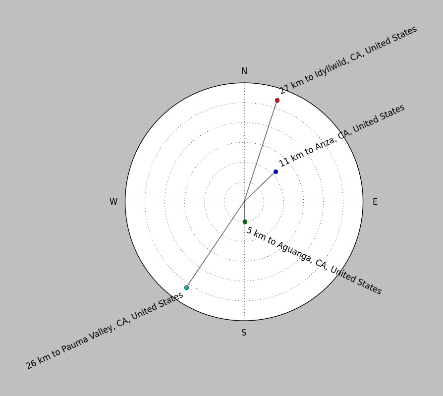
| ||||||||||||||||
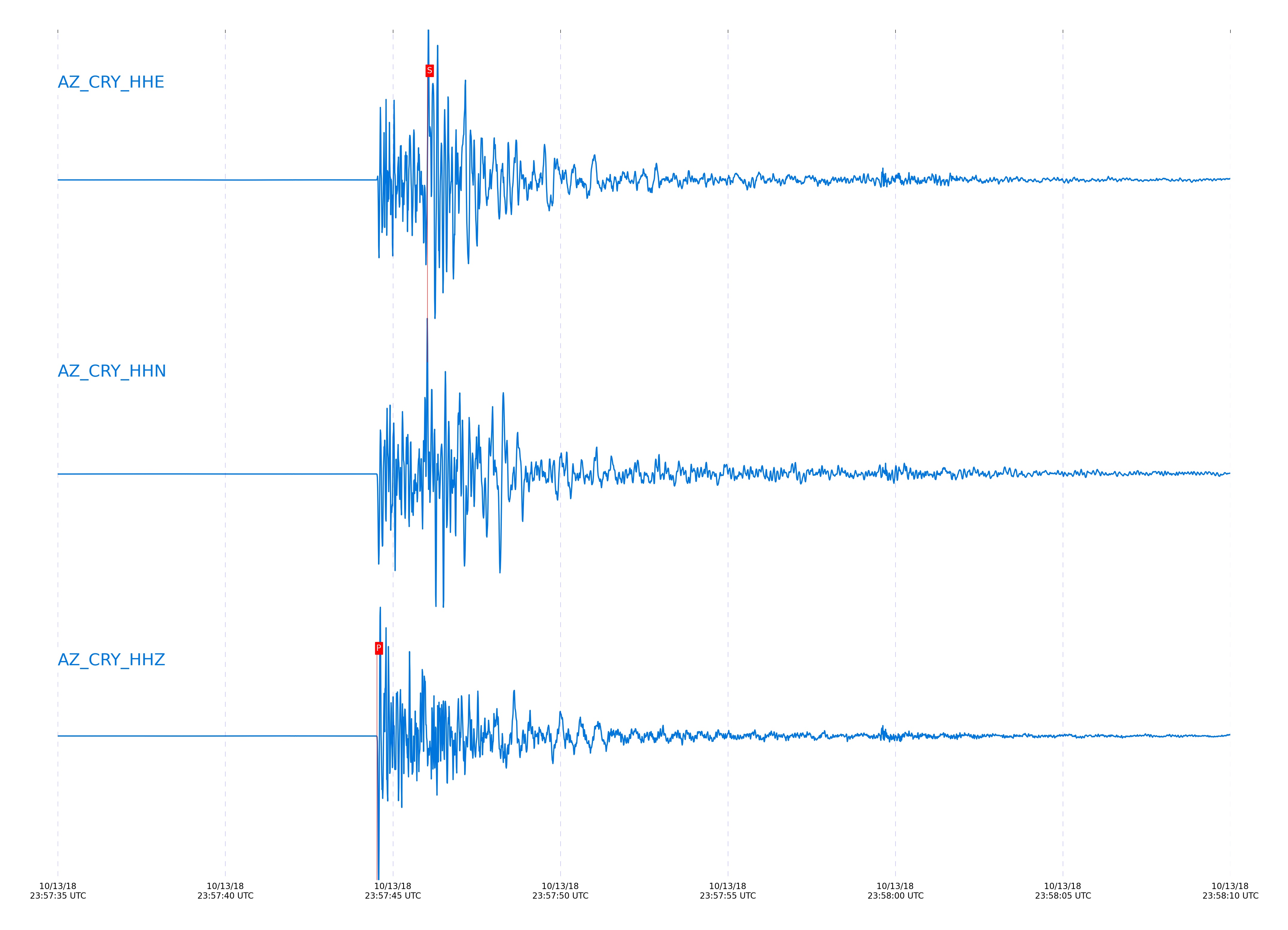
Event and active stations
|
|||||||||||||||||
Closest station with identified signal. Not filtered.
Subset of several stations close to the event. Not filtered.
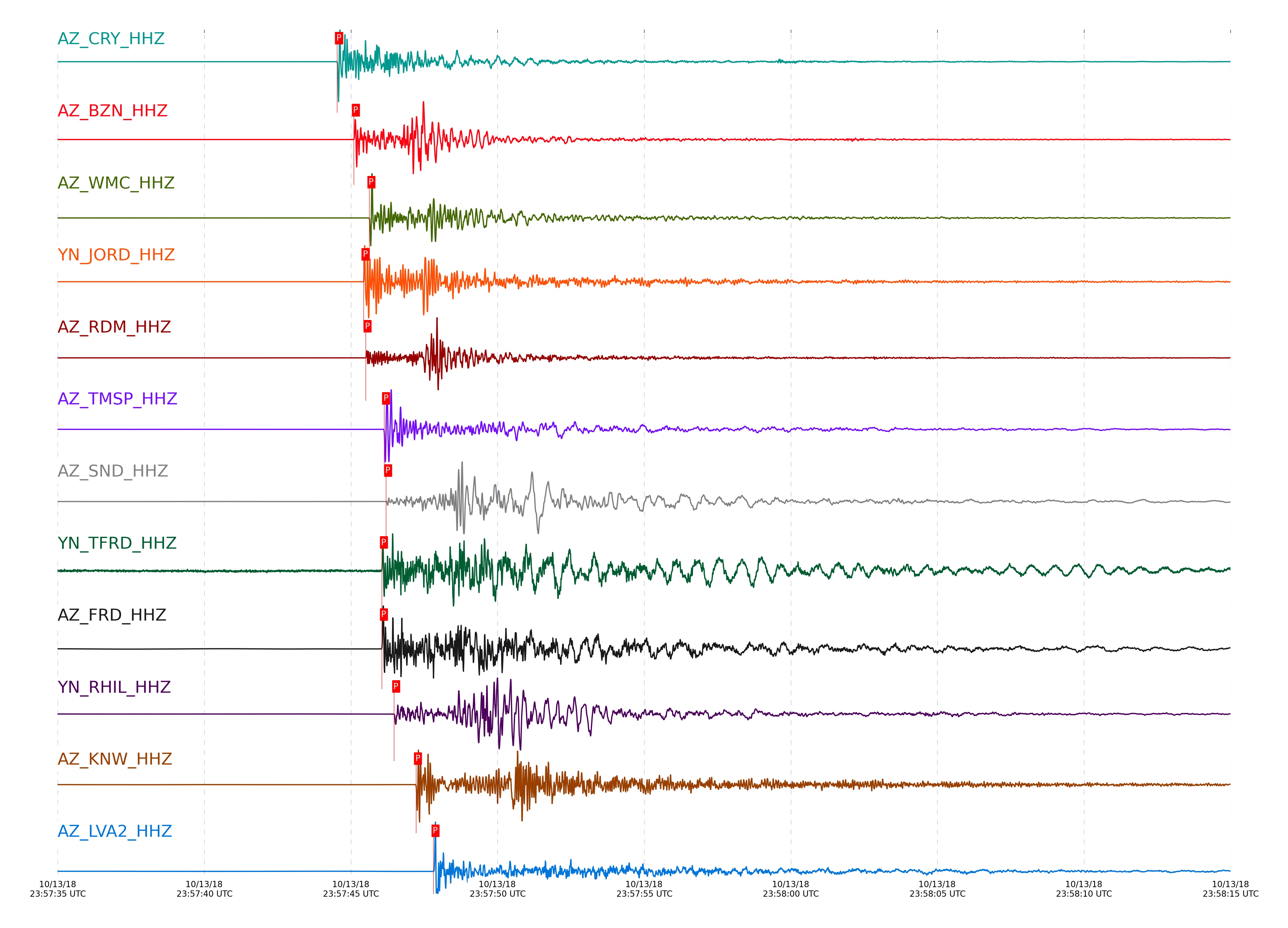
| STA_CHAN | S-E Delta | S-E Azimuth | Phase | Time | Signal/Noise | Time Residual | V. Model | Auth | arid |
|---|---|---|---|---|---|---|---|---|---|
| CRY_HHZ | 0.085° | 219.08° | P | 2018-10-13 23:57:44.5258 UTC | 7600.2 | -0.096 | iasp91 | dbp:tcox:18306 | 1921064 |
| CRY_HHE | 0.085° | 219.08° | S | 2018-10-13 23:57:46.0346 UTC | -1 | -0.012 | iasp91 | dbp:tcox:18306 | 1942575 |
| BZN_HHZ | 0.112° | 274.24° | P | 2018-10-13 23:57:45.0963 UTC | 7745.5 | 0.003 | iasp91 | dbp:tcox:18306 | 1921066 |
| BZN_HHE | 0.112° | 274.24° | S | 2018-10-13 23:57:46.8634 UTC | -1 | 0.045 | iasp91 | dbp:tcox:18306 | 1942576 |
| WMC_HHN | 0.129° | 235.03° | S | 2018-10-13 23:57:47.5608 UTC | -1 | 0.21 | iasp91 | dbp:tcox:18306 | 1942578 |
| WMC_HHZ | 0.129° | 235.03° | P | 2018-10-13 23:57:45.6265 UTC | 557.45 | 0.225 | iasp91 | dbp:tcox:18306 | 1921072 |
| JORD_HHZ | 0.133° | 281.97° | P | 2018-10-13 23:57:45.4312 UTC | 8037.6 | -0.05 | iasp91 | dbp:tcox:18306 | 1921068 |
| JORD_HHE | 0.133° | 281.97° | S | 2018-10-13 23:57:47.4352 UTC | -1 | -0.052 | iasp91 | dbp:tcox:18306 | 1942577 |
| RDM_HHE | 0.136° | 163.4° | S | 2018-10-13 23:57:47.5068 UTC | -1 | -0.096 | iasp91 | dbp:tcox:18306 | 1942579 |
| RDM_HHZ | 0.136° | 163.4° | P | 2018-10-13 23:57:45.5002 UTC | 3355.4 | -0.046 | iasp91 | dbp:tcox:18306 | 1921070 |
| TMSP_HHZ | 0.156° | 220.04° | P | 2018-10-13 23:57:46.1293 UTC | 4820.2 | 0.129 | iasp91 | dbp:tcox:18306 | 1921075 |
| FRD_HHZ | 0.166° | 271.79° | P | 2018-10-13 23:57:46.053 UTC | 862.18 | -0.042 | iasp91 | dbp:tcox:18306 | 1921077 |
| SND_HHZ | 0.166° | 251.67° | P | 2018-10-13 23:57:46.1959 UTC | 7936.1 | 0.092 | iasp91 | dbp:tcox:18306 | 1921081 |
| TFRD_HHZ | 0.166° | 271.76° | P | 2018-10-13 23:57:46.0531 UTC | 23.759 | -0.025 | iasp91 | dbp:tcox:18306 | 1921079 |
| SND_HHE | 0.166° | 251.67° | S | 2018-10-13 23:57:48.6589 UTC | -1 | 0.094 | iasp91 | dbp:tcox:18306 | 1942582 |
| FRD_HHE | 0.166° | 271.79° | S | 2018-10-13 23:57:48.3716 UTC | -1 | -0.173 | iasp91 | dbp:tcox:18306 | 1942580 |
| TFRD_HHE | 0.166° | 271.76° | S | 2018-10-13 23:57:48.4314 UTC | -1 | -0.08 | iasp91 | dbp:tcox:18306 | 1942581 |
| RHIL_HHZ | 0.175° | 188.19° | P | 2018-10-13 23:57:46.4732 UTC | 8030.7 | 0.163 | iasp91 | dbp:tcox:18306 | 1921083 |
| KNW_HHZ | 0.227° | 199.17° | P | 2018-10-13 23:57:47.2204 UTC | 3443.6 | -0.065 | iasp91 | dbp:tcox:18306 | 1921103 |
| LVA2_HHZ | 0.249° | 306.58° | P | 2018-10-13 23:57:47.8149 UTC | 7628.8 | 0.117 | iasp91 | dbp:tcox:18306 | 1921105 |
| PFO_HHZ | 0.306° | 248.64° | P | 2018-10-13 23:57:48.6976 UTC | 543.73 | -0.072 | iasp91 | dbp:tcox:18306 | 1921124 |
| SMER_HHZ | 0.311° | 82.13° | P | 2018-10-13 23:57:48.9142 UTC | 431.58 | 0.141 | iasp91 | dbp:tcox:18306 | 1921107 |
| TRO_HHZ | 0.314° | 265.78° | P | 2018-10-13 23:57:48.9777 UTC | 1466.9 | -0.084 | iasp91 | dbp:tcox:18306 | 1921108 |
Click the link below to observe an interactive map of earthquakes recorded by the station deployment:
Broadband Seismic Data Collection Center (ANZA),
Institute of Geophysics & Planetary Physics
Scripps Institution of Oceanography,
University of California San Diego
Copyright © 1989 - 2014. All Rights Reserved.