
last update to page: March 15 2016 21:39:11 (UTC).
SummaryThe red marker denotes the earthquake epicenter. On Wed Sep 16th 2015 22:54:32 (UTC) the seismic network recorded an earthquake (preliminary 8.3 mww) located in Near Coast Of Central Chile. Seismic region Andean South America. The epicentral distance (i.e. distance separating the location to the epicenter) to the closest station USGCB in the network is 8,567.8 km. If you felt the quake, the USGS would like to know. Please add your comments to the USGS page "Did you feel it?". |
Details
Proximity to Population Centers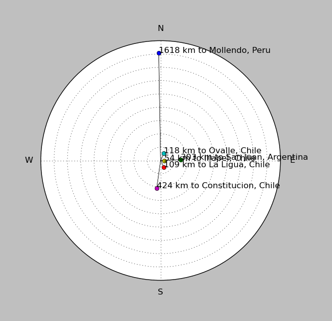
| ||||||||||||||||
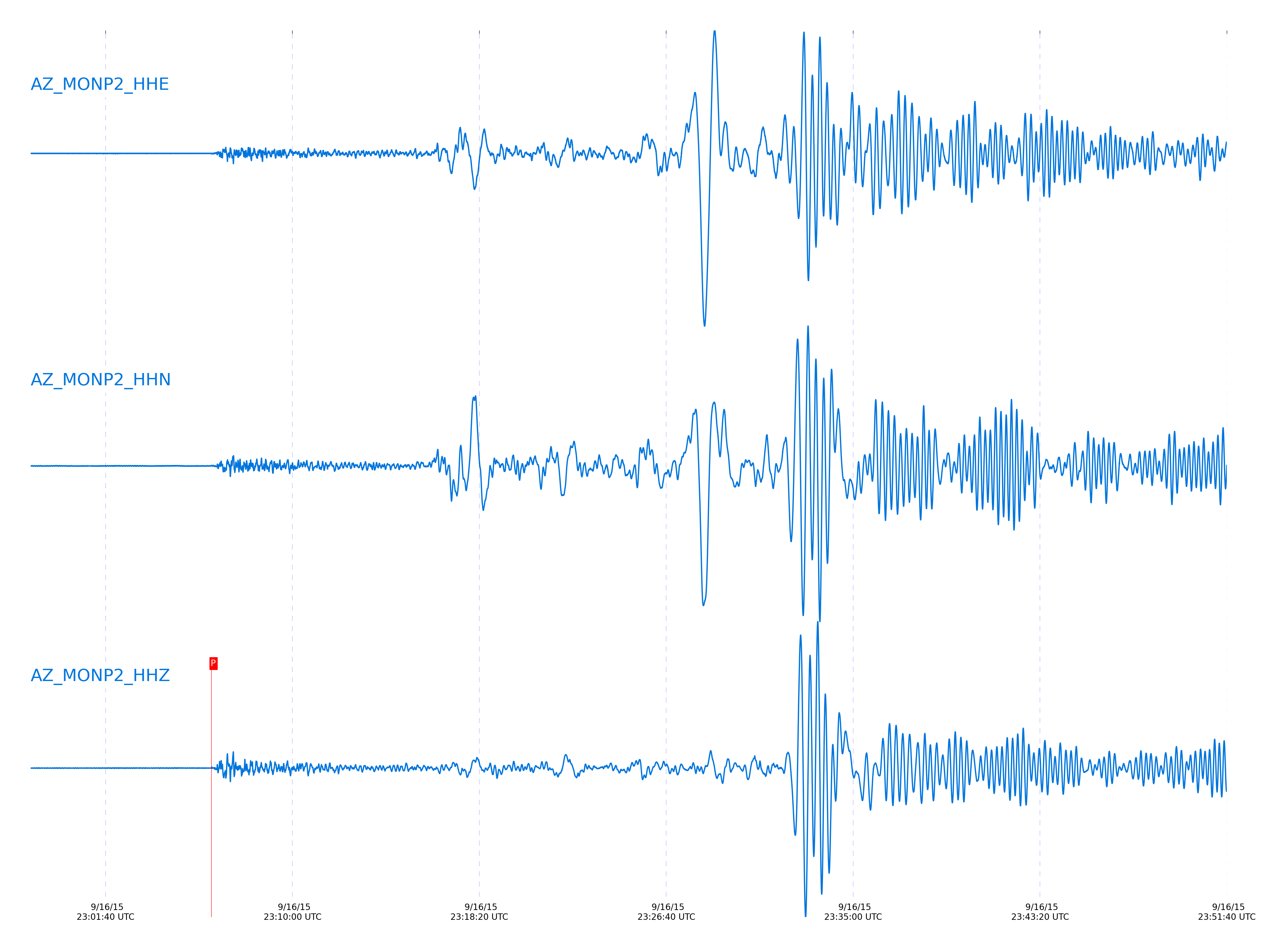
Event and active stations
|
|||||||||||||||||
Closest station with identified signal. Not filtered.
Subset of several stations close to the event. Not filtered.
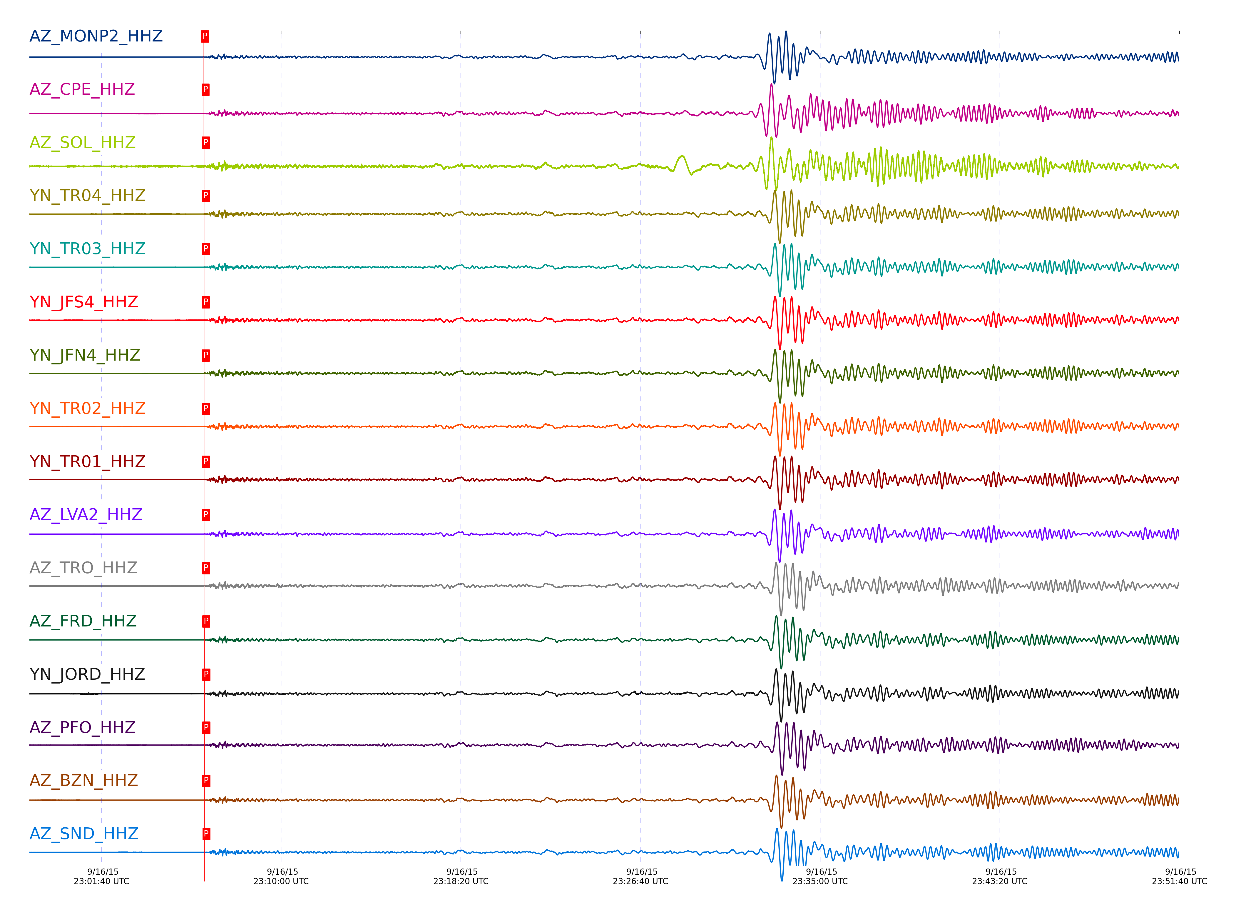
| STA_CHAN | S-E Delta | S-E Azimuth | Phase | Time | Signal/Noise | Time Residual | V. Model | Auth | arid |
|---|---|---|---|---|---|---|---|---|---|
| MONP2_HHZ | 77.03° | 142.06° | P | 2015-09-16 23:06:23.2562 UTC | 46.656 | -0.537 | iasp91 | dbp:jtytell:152 | 770791 |
| CPE_HHZ | 77.382° | 141.58° | P | 2015-09-16 23:06:24.6856 UTC | 23.722 | -1.082 | iasp91 | dbp:jtytell:152 | 770795 |
| SOL_HHZ | 77.419° | 141.48° | P | 2015-09-16 23:06:25.4528 UTC | 16.904 | -0.523 | iasp91 | dbp:rt:15260 | 770800 |
| TR04_HHZ | 77.432° | 142.13° | P | 2015-09-16 23:06:25.5875 UTC | -1 | -0.459 | iasp91 | dbp:jtytell:152 | 770804 |
| TR03_HHZ | 77.439° | 142.13° | P | 2015-09-16 23:06:25.5101 UTC | -1 | -0.576 | iasp91 | dbp:jtytell:152 | 770801 |
| JFN4_HHZ | 77.439° | 142.15° | P | 2015-09-16 23:06:25.5516 UTC | -1 | -0.537 | iasp91 | dbp:jtytell:152 | 770802 |
| JFS4_HHZ | 77.439° | 142.14° | P | 2015-09-16 23:06:25.5886 UTC | -1 | -0.498 | iasp91 | dbp:jtytell:152 | 770805 |
| TR02_HHZ | 77.443° | 142.13° | P | 2015-09-16 23:06:25.5693 UTC | -1 | -0.537 | iasp91 | dbp:jtytell:152 | 770803 |
| TR01_HHZ | 77.444° | 142.14° | P | 2015-09-16 23:06:25.6191 UTC | 55.425 | -0.498 | iasp91 | dbp:jtytell:152 | 770806 |
| LVA2_HHZ | 77.464° | 142.02° | P | 2015-09-16 23:06:25.8461 UTC | 51.27 | -0.381 | iasp91 | dbp:jtytell:152 | 770810 |
| TRO_HHZ | 77.53° | 142.14° | P | 2015-09-16 23:06:26.1754 UTC | 63.864 | -0.42 | iasp91 | dbp:jtytell:152 | 770812 |
| FRD_HHZ | 77.598° | 142.02° | P | 2015-09-16 23:06:26.515 UTC | 81.185 | -0.459 | iasp91 | dbp:jtytell:152 | 770819 |
| JORD_HHZ | 77.602° | 141.98° | P | 2015-09-16 23:06:26.5387 UTC | 60.236 | -0.459 | iasp91 | dbp:jtytell:152 | 770823 |
| PFO_HHZ | 77.617° | 142.13° | P | 2015-09-16 23:06:26.544 UTC | 89.111 | -0.537 | iasp91 | dbp:jtytell:152 | 770824 |
| BZN_HHZ | 77.629° | 141.97° | P | 2015-09-16 23:06:26.6866 UTC | 72.795 | -0.459 | iasp91 | dbp:jtytell:152 | 770828 |
| SND_HHZ | 77.648° | 142.02° | P | 2015-09-16 23:06:26.9529 UTC | 48.062 | -0.303 | iasp91 | dbp:jtytell:152 | 770830 |
| WMC_HHZ | 77.697° | 141.98° | P | 2015-09-16 23:06:27.1861 UTC | 73.507 | -0.342 | iasp91 | dbp:jtytell:152 | 770833 |
| CRY_HHZ | 77.723° | 141.93° | P | 2015-09-16 23:06:27.2124 UTC | 73.484 | -0.459 | iasp91 | dbp:jtytell:152 | 770834 |
| TMSP_HHZ | 77.736° | 141.98° | P | 2015-09-16 23:06:27.5598 UTC | -1 | -0.186 | iasp91 | dbp:jtytell:152 | 770836 |
| RRSP_HHZ | 77.792° | 141.94° | P | 2015-09-16 23:06:27.7907 UTC | -1 | -0.264 | iasp91 | dbp:jtytell:152 | 770840 |
| BCCC_HHZ | 77.825° | 141.89° | P | 2015-09-16 23:06:27.8575 UTC | 107.96 | -0.381 | iasp91 | dbp:jtytell:152 | 770843 |
| KNW_HHZ | 77.827° | 141.97° | P | 2015-09-16 23:06:27.7529 UTC | 81.852 | -0.498 | iasp91 | dbp:jtytell:152 | 770838 |
| RDM_HHZ | 77.831° | 141.86° | P | 2015-09-16 23:06:27.8117 UTC | 103.51 | -0.459 | iasp91 | dbp:jtytell:152 | 770841 |
| SMER_HHZ | 77.862° | 141.62° | P | 2015-09-16 23:06:27.4801 UTC | 77.001 | -0.965 | iasp91 | dbp:jtytell:152 | 770835 |
| SCI2_HHZ | 78.131° | 140.64° | P | 2015-09-16 23:06:29.3335 UTC | 22.634 | -0.606 | iasp91 | dbp:jtytell:152 | 770847 |
Click the link below to observe an interactive map of earthquakes recorded by the station deployment:
Broadband Seismic Data Collection Center (ANZA),
Institute of Geophysics & Planetary Physics
Scripps Institution of Oceanography,
University of California San Diego
Copyright © 1989 - 2014. All Rights Reserved.