
last update to page: March 15 2016 21:53:44 (UTC).
SummaryThe red marker denotes the earthquake epicenter. On Tue Oct 20th 2015 21:52:02 (UTC) the seismic network recorded an earthquake (preliminary 7.3 mwp) located in Vanuatu Islands. Seismic region New Hebrides Islands. The epicentral distance (i.e. distance separating the location to the epicenter) to the closest station SCI2 in the network is 9,498.5 km. If you felt the quake, the USGS would like to know. Please add your comments to the USGS page "Did you feel it?". |
Details
Proximity to Population Centers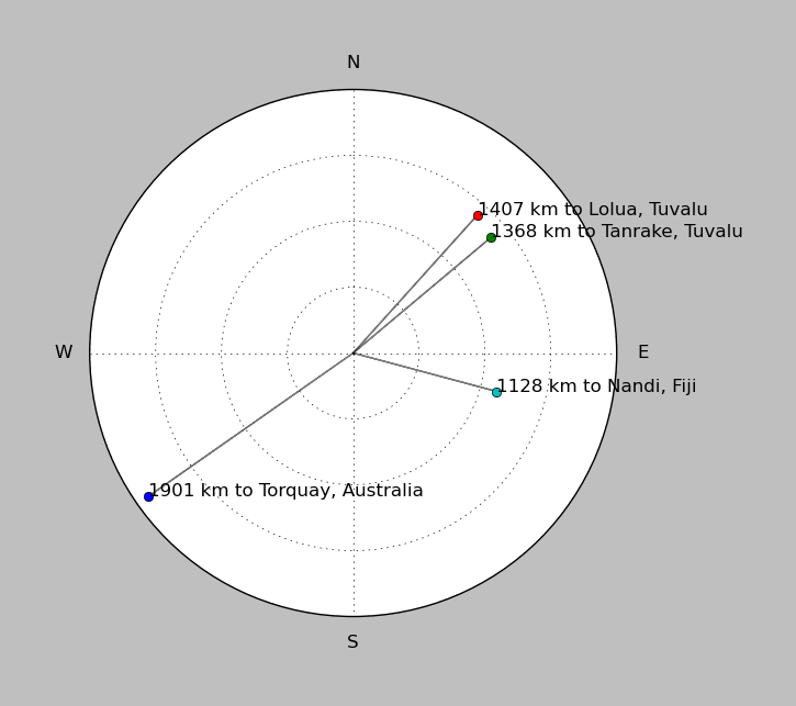
| ||||||||||||||||
Event and active stations
|
|||||||||||||||||
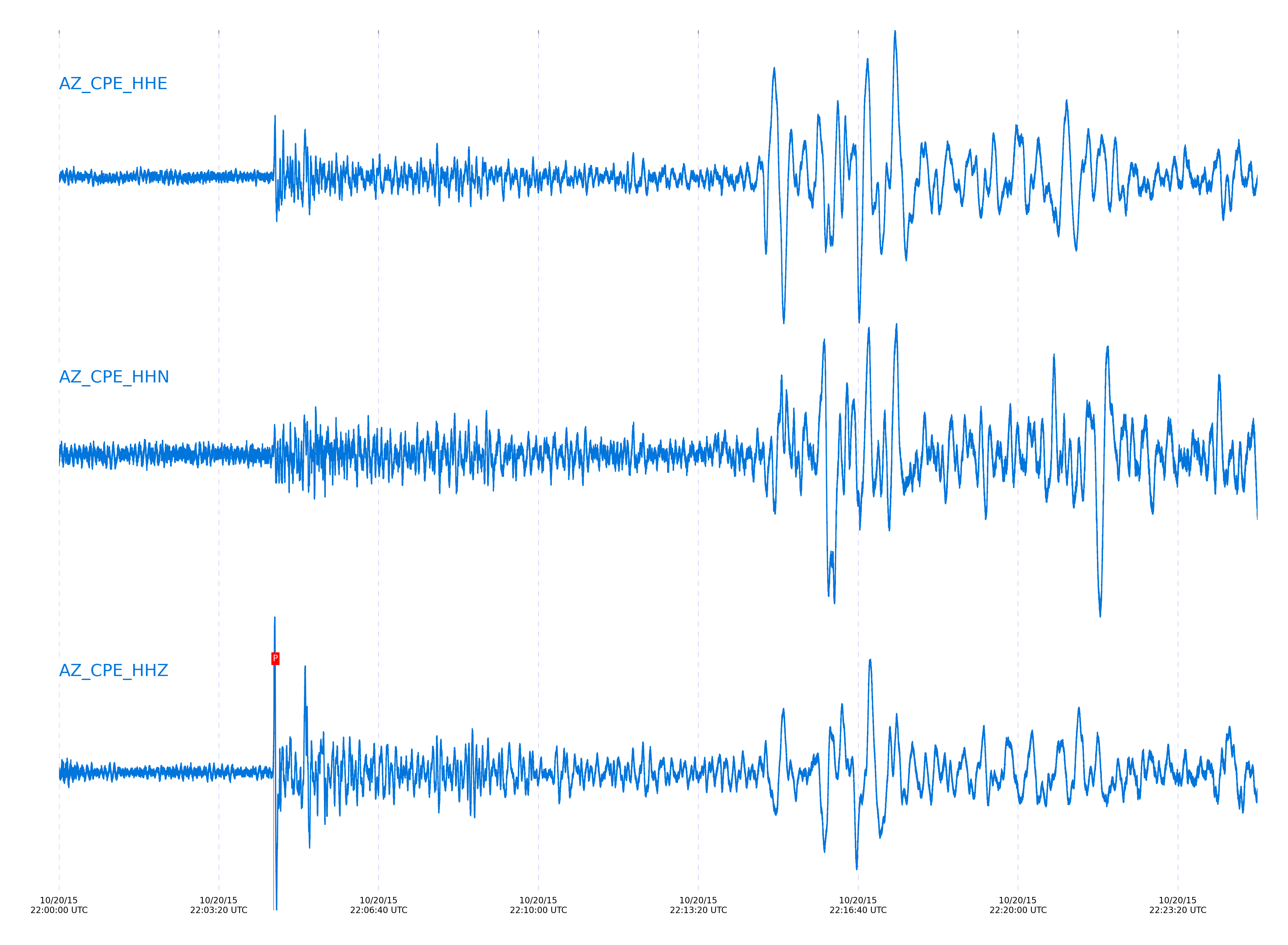
Closest station with identified signal. Not filtered.
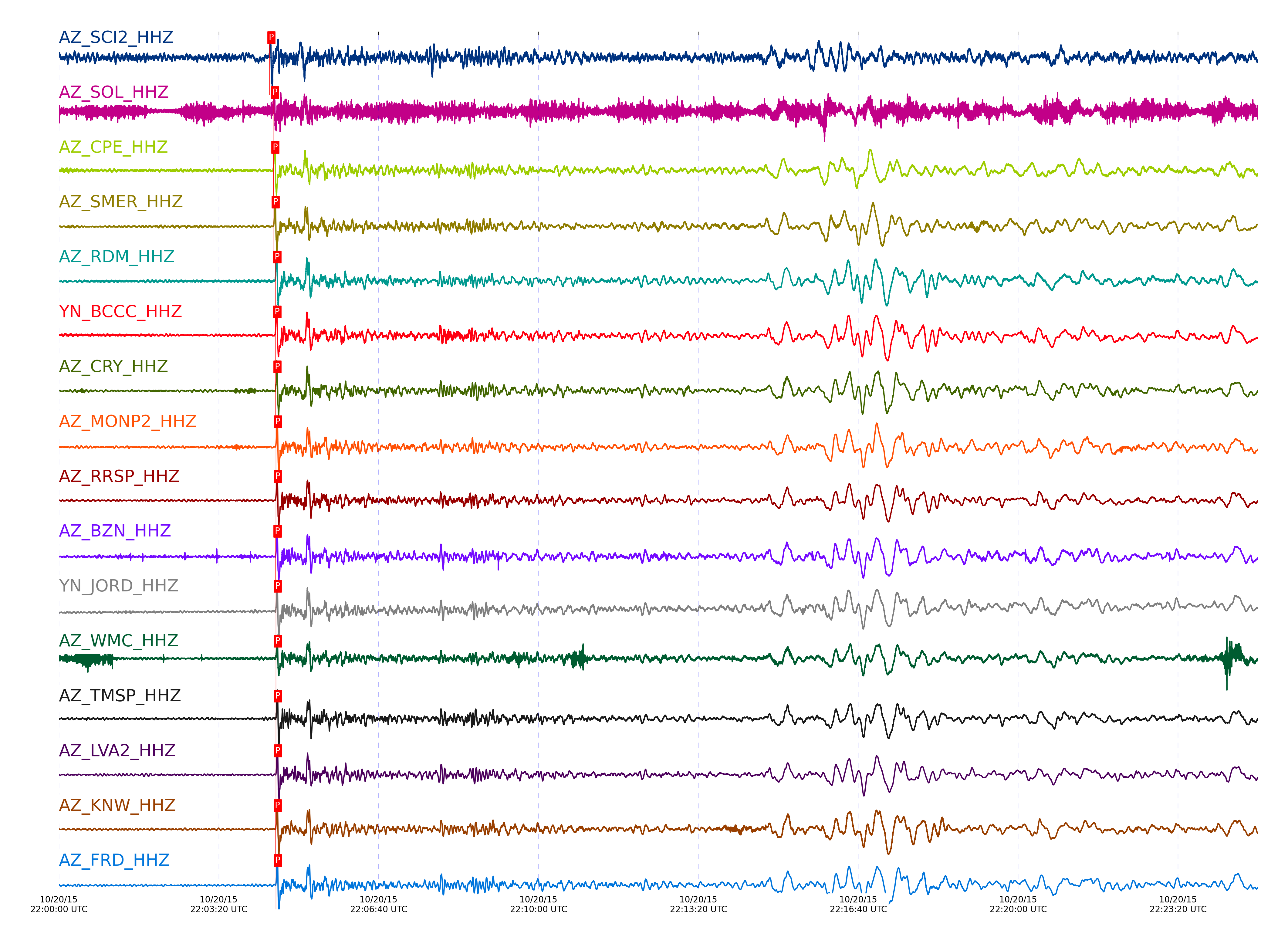
Subset of several stations close to the event. Not filtered.
| STA_CHAN | S-E Delta | S-E Azimuth | Phase | Time | Signal/Noise | Time Residual | V. Model | Auth | arid |
|---|---|---|---|---|---|---|---|---|---|
| SCI2_HHZ | 85.326° | 248.93° | P | 2015-10-20 22:04:23.4267 UTC | 12.356 | -1.086 | iasp91 | dbp:jtytell:152 | 782018 |
| SOL_HHZ | 86.274° | 249.64° | P | 2015-10-20 22:04:27.9974 UTC | -1 | -1.183 | iasp91 | dbp:jtytell:152 | 782024 |
| CPE_HHZ | 86.403° | 249.72° | P | 2015-10-20 22:04:28.38 UTC | 32.596 | -1.431 | iasp91 | dbp:jtytell:152 | 782026 |
| SMER_HHZ | 86.549° | 249.65° | P | 2015-10-20 22:04:28.6929 UTC | -1 | -1.829 | iasp91 | dbp:jtytell:152 | 782030 |
| RDM_HHZ | 86.861° | 249.82° | P | 2015-10-20 22:04:30.7035 UTC | 60.5 | -1.332 | iasp91 | dbp:jtytell:152 | 782040 |
| BCCC_HHZ | 86.896° | 249.84° | P | 2015-10-20 22:04:30.7722 UTC | 66.588 | -1.431 | iasp91 | dbp:jtytell:152 | 782042 |
| CRY_HHZ | 86.925° | 249.89° | P | 2015-10-20 22:04:31.0132 UTC | 59.183 | -1.331 | iasp91 | dbp:jtytell:152 | 782045 |
| MONP2_HHZ | 86.943° | 250.1° | P | 2015-10-20 22:04:31.5442 UTC | 45.169 | -0.883 | iasp91 | dbp:jtytell:152 | 782059 |
| RRSP_HHZ | 86.953° | 249.88° | P | 2015-10-20 22:04:31.3467 UTC | -1 | -1.132 | iasp91 | dbp:jtytell:152 | 782049 |
| BZN_HHZ | 86.955° | 249.93° | P | 2015-10-20 22:04:31.1562 UTC | 59.956 | -1.331 | iasp91 | dbp:jtytell:152 | 782046 |
| JORD_HHZ | 86.966° | 249.94° | P | 2015-10-20 22:04:31.3565 UTC | 65.636 | -1.182 | iasp91 | dbp:jtytell:152 | 782050 |
| WMC_HHZ | 86.977° | 249.92° | P | 2015-10-20 22:04:31.4616 UTC | 44.643 | -1.132 | iasp91 | dbp:jtytell:152 | 782052 |
| TMSP_HHZ | 86.988° | 249.92° | P | 2015-10-20 22:04:31.4638 UTC | -1 | -1.182 | iasp91 | dbp:jtytell:152 | 782053 |
| LVA2_HHZ | 86.99° | 250° | P | 2015-10-20 22:04:31.6718 UTC | 62.038 | -0.983 | iasp91 | dbp:jtytell:152 | 782061 |
| KNW_HHZ | 86.996° | 249.89° | P | 2015-10-20 22:04:31.2555 UTC | 67.085 | -1.431 | iasp91 | dbp:jtytell:152 | 782047 |
| FRD_HHZ | 87.007° | 249.97° | P | 2015-10-20 22:04:31.5052 UTC | 50.933 | -1.231 | iasp91 | dbp:jtytell:152 | 782056 |
| SND_HHZ | 87.018° | 249.96° | P | 2015-10-20 22:04:31.6088 UTC | 37.509 | -1.182 | iasp91 | dbp:jtytell:152 | 782060 |
| TR04_HHZ | 87.112° | 250.07° | P | 2015-10-20 22:04:32.1604 UTC | -1 | -1.082 | iasp91 | dbp:jtytell:152 | 782073 |
| TR03_HHZ | 87.118° | 250.07° | P | 2015-10-20 22:04:32.1383 UTC | -1 | -1.131 | iasp91 | dbp:jtytell:152 | 782072 |
| TR02_HHZ | 87.126° | 250.07° | P | 2015-10-20 22:04:32.1274 UTC | -1 | -1.181 | iasp91 | dbp:jtytell:152 | 782069 |
| TR01_HHZ | 87.13° | 250.08° | P | 2015-10-20 22:04:32.1969 UTC | 40.734 | -1.131 | iasp91 | dbp:jtytell:152 | 782077 |
| JFS4_HHZ | 87.138° | 250.08° | P | 2015-10-20 22:04:32.133 UTC | -1 | -1.231 | iasp91 | dbp:jtytell:152 | 782070 |
| JFN4_HHZ | 87.141° | 250.08° | P | 2015-10-20 22:04:32.247 UTC | -1 | -1.131 | iasp91 | dbp:jtytell:152 | 782080 |
| TRO_HHZ | 87.155° | 250.06° | P | 2015-10-20 22:04:32.464 UTC | 53.16 | -0.982 | iasp91 | dbp:jtytell:152 | 782083 |
| PFO_HHZ | 87.159° | 250.04° | P | 2015-10-20 22:04:32.0841 UTC | 48.687 | -1.38 | iasp91 | dbp:jtytell:152 | 782065 |
Click the link below to observe an interactive map of earthquakes recorded by the station deployment:
Broadband Seismic Data Collection Center (ANZA),
Institute of Geophysics & Planetary Physics
Scripps Institution of Oceanography,
University of California San Diego
Copyright © 1989 - 2014. All Rights Reserved.