
last update to page: March 16 2016 23:02:57 (UTC).
SummaryThe red marker denotes the earthquake epicenter. On Sat Jan 30th 2016 03:25:10 (UTC) the seismic network recorded an earthquake (preliminary 7.2 mww) located in Kamchatka Peninsula, Russia. Seismic region Japan - Kuriles - Kamchatka. The epicentral distance (i.e. distance separating the location to the epicenter) to the closest station CSLB in the network is 6,633.7 km. If you felt the quake, the USGS would like to know. Please add your comments to the USGS page "Did you feel it?". |
Details
Proximity to Population Centers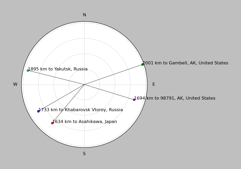
| ||||||||||||||||
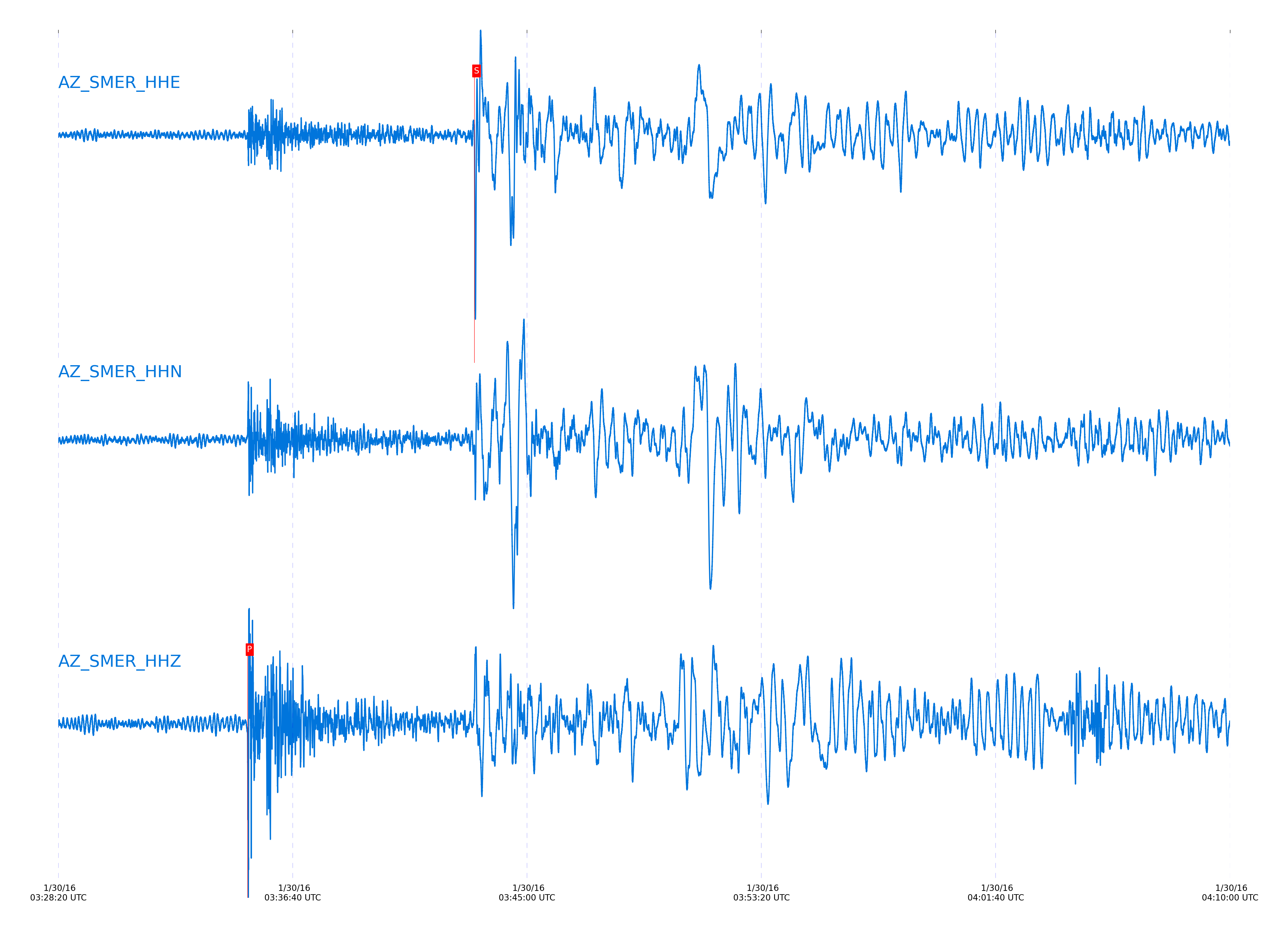
Event and active stations
|
|||||||||||||||||
Closest station with identified signal. Not filtered.
Subset of several stations close to the event. Not filtered.
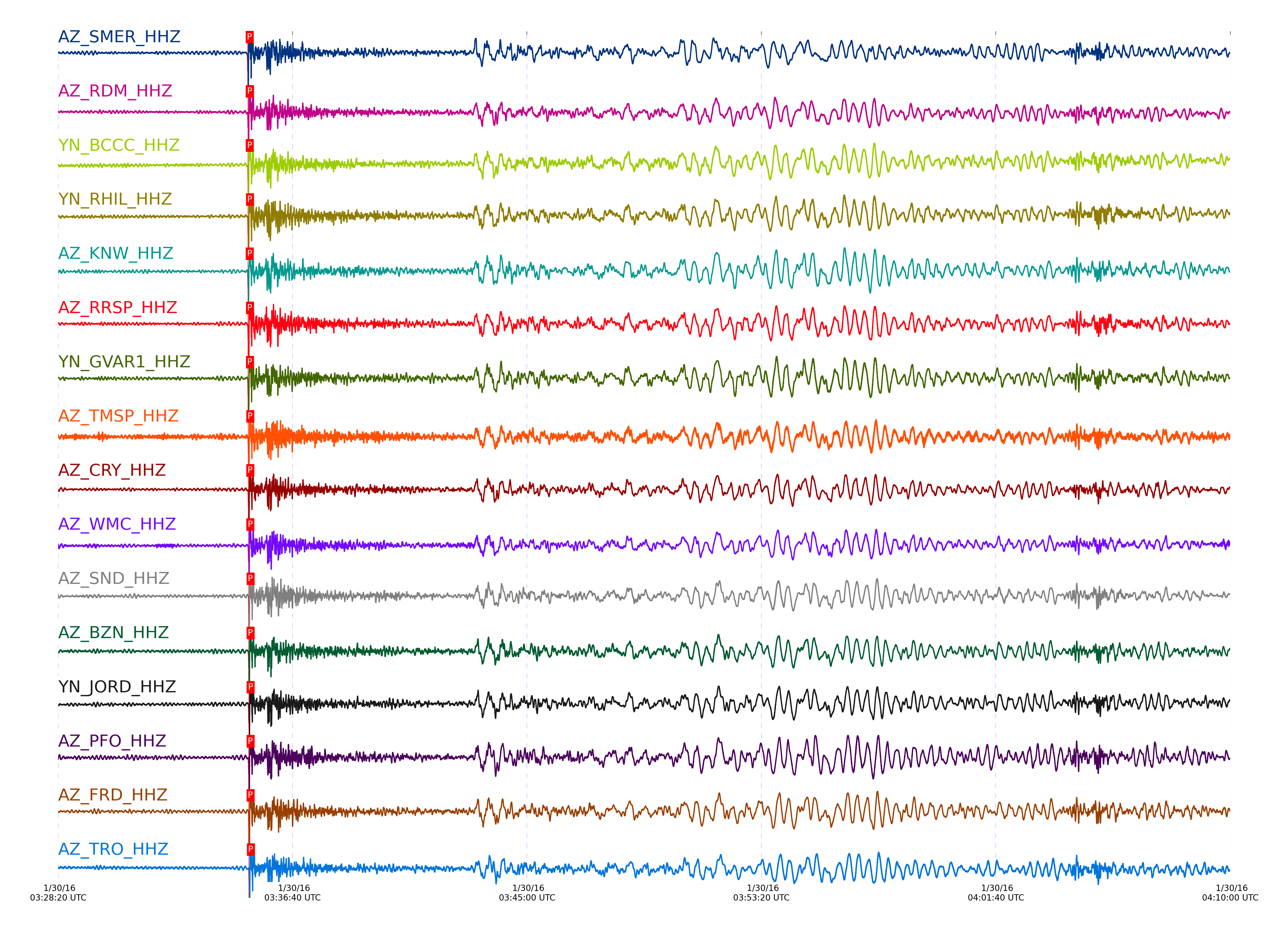
| STA_CHAN | S-E Delta | S-E Azimuth | Phase | Time | Signal/Noise | Time Residual | V. Model | Auth | arid |
|---|---|---|---|---|---|---|---|---|---|
| SMER_HHE | 60.359° | 317.71° | S | 2016-01-30 03:43:07.9154 UTC | -1 | 3.126 | iasp91 | dbp:jtytell:160 | 920316 |
| SMER_HHZ | 60.359° | 317.71° | P | 2016-01-30 03:35:04.2219 UTC | 19.807 | 1.888 | iasp91 | dbp:jtytell:160 | 919168 |
| RDM_HHE | 60.412° | 317.71° | S | 2016-01-30 03:43:07.9324 UTC | -1 | 2.46 | iasp91 | dbp:jtytell:160 | 920317 |
| RDM_HHZ | 60.412° | 317.71° | P | 2016-01-30 03:35:04.7356 UTC | 270.23 | 2.037 | iasp91 | dbp:jtytell:160 | 919199 |
| BCCC_HHE | 60.421° | 317.71° | S | 2016-01-30 03:43:08.2204 UTC | -1 | 2.643 | iasp91 | dbp:jtytell:160 | 920318 |
| BCCC_HHZ | 60.421° | 317.71° | P | 2016-01-30 03:35:04.593 UTC | 236.26 | 1.839 | iasp91 | dbp:jtytell:160 | 919202 |
| RHIL_HHE | 60.423° | 317.71° | S | 2016-01-30 03:43:08.7015 UTC | -1 | 3.09 | iasp91 | dbp:jtytell:160 | 920319 |
| RHIL_HHZ | 60.423° | 317.71° | P | 2016-01-30 03:35:04.8592 UTC | -1 | 2.087 | iasp91 | dbp:jtytell:160 | 920254 |
| KNW_HHE | 60.426° | 317.71° | S | 2016-01-30 03:43:08.0267 UTC | -1 | 2.377 | iasp91 | dbp:jtytell:160 | 920320 |
| KNW_HHZ | 60.426° | 317.71° | P | 2016-01-30 03:35:04.6311 UTC | 8.7379 | 1.839 | iasp91 | dbp:jtytell:160 | 919169 |
| RRSP_HHZ | 60.457° | 317.73° | P | 2016-01-30 03:35:05.0398 UTC | -1 | 2.037 | iasp91 | dbp:jtytell:160 | 920259 |
| RRSP_HHE | 60.457° | 317.73° | S | 2016-01-30 03:43:09.0477 UTC | -1 | 3.005 | iasp91 | dbp:jtytell:160 | 920325 |
| GVAR1_HHZ | 60.464° | 317.73° | P | 2016-01-30 03:35:04.941 UTC | 12.277 | 1.888 | iasp91 | dbp:jtytell:160 | 919170 |
| GVAR1_HHE | 60.464° | 317.73° | S | 2016-01-30 03:43:08.8663 UTC | -1 | 2.729 | iasp91 | dbp:jtytell:160 | 920327 |
| TMSP_HHE | 60.514° | 317.75° | S | 2016-01-30 03:43:10.1274 UTC | -1 | 3.364 | iasp91 | dbp:jtytell:160 | 920328 |
| TMSP_HHZ | 60.514° | 317.75° | P | 2016-01-30 03:35:05.5733 UTC | -1 | 2.186 | iasp91 | dbp:jtytell:160 | 920260 |
| CRY_HHZ | 60.522° | 317.76° | P | 2016-01-30 03:35:05.5795 UTC | 264.66 | 2.137 | iasp91 | dbp:jtytell:160 | 919203 |
| CRY_HHE | 60.522° | 317.76° | S | 2016-01-30 03:43:09.6039 UTC | -1 | 2.736 | iasp91 | dbp:jtytell:160 | 920329 |
| WMC_HHE | 60.551° | 317.77° | S | 2016-01-30 03:43:10.2639 UTC | -1 | 3.027 | iasp91 | dbp:jtytell:160 | 920331 |
| WMC_HHZ | 60.551° | 317.77° | P | 2016-01-30 03:35:05.8258 UTC | 226.87 | 2.186 | iasp91 | dbp:jtytell:160 | 919204 |
| SND_HHZ | 60.602° | 317.79° | P | 2016-01-30 03:35:06.1196 UTC | 124.23 | 2.137 | iasp91 | dbp:jtytell:160 | 919207 |
| SND_HHE | 60.602° | 317.79° | S | 2016-01-30 03:43:11.071 UTC | -1 | 3.19 | iasp91 | dbp:jtytell:160 | 920334 |
| BZN_HHZ | 60.616° | 317.8° | P | 2016-01-30 03:35:06.2175 UTC | 166.67 | 2.137 | iasp91 | dbp:jtytell:160 | 919197 |
| BZN_HHE | 60.616° | 317.8° | S | 2016-01-30 03:43:10.8212 UTC | -1 | 2.757 | iasp91 | dbp:jtytell:160 | 920336 |
| JORD_HHZ | 60.643° | 317.81° | P | 2016-01-30 03:35:06.3978 UTC | 168.44 | 2.137 | iasp91 | dbp:jtytell:160 | 919208 |
| PFO_HHZ | 60.643° | 317.8° | P | 2016-01-30 03:35:06.1034 UTC | 157.73 | 1.839 | iasp91 | dbp:jtytell:160 | 919205 |
| PFO_HHE | 60.643° | 317.8° | S | 2016-01-30 03:43:10.7736 UTC | -1 | 2.364 | iasp91 | dbp:jtytell:160 | 920340 |
| JORD_HHE | 60.643° | 317.81° | S | 2016-01-30 03:43:11.5809 UTC | -1 | 3.178 | iasp91 | dbp:jtytell:160 | 920339 |
| FRD_HHZ | 60.65° | 317.81° | P | 2016-01-30 03:35:06.2983 UTC | 15.143 | 1.988 | iasp91 | dbp:jtytell:160 | 919167 |
| FRD_HHE | 60.65° | 317.81° | S | 2016-01-30 03:43:11.5145 UTC | -1 | 3.019 | iasp91 | dbp:jtytell:160 | 920346 |
| TRO_HHE | 60.728° | 317.84° | S | 2016-01-30 03:43:12.7346 UTC | -1 | 3.255 | iasp91 | dbp:jtytell:160 | 920352 |
| TRO_HHZ | 60.728° | 317.84° | P | 2016-01-30 03:35:06.9722 UTC | 207.88 | 2.137 | iasp91 | dbp:jtytell:160 | 919209 |
| SOL_HHE | 60.772° | 317.93° | S | 2016-01-30 03:43:13.8479 UTC | -1 | 3.802 | iasp91 | dbp:jtytell:160 | 920354 |
| SOL_HHZ | 60.772° | 317.93° | P | 2016-01-30 03:35:07.2744 UTC | 39.421 | 2.137 | iasp91 | dbp:jtytell:160 | 919215 |
| LVA2_HHE | 60.779° | 317.88° | S | 2016-01-30 03:43:14.2407 UTC | -1 | 4.11 | iasp91 | dbp:jtytell:160 | 920355 |
| LVA2_HHZ | 60.779° | 317.88° | P | 2016-01-30 03:35:07.5184 UTC | 37.727 | 2.335 | iasp91 | dbp:jtytell:160 | 919172 |
| TR01_HHZ | 60.809° | 317.88° | P | 2016-01-30 03:35:07.4729 UTC | 62.573 | 2.087 | iasp91 | dbp:jtytell:160 | 919171 |
| TR01_HHE | 60.809° | 317.88° | S | 2016-01-30 03:43:13.8643 UTC | -1 | 3.353 | iasp91 | dbp:jtytell:160 | 920357 |
| TR02_HHZ | 60.81° | 317.88° | P | 2016-01-30 03:35:07.5331 UTC | -1 | 2.137 | iasp91 | dbp:jtytell:160 | 920275 |
| TR02_HHE | 60.81° | 317.88° | S | 2016-01-30 03:43:13.759 UTC | -1 | 3.227 | iasp91 | dbp:jtytell:160 | 920358 |
| TR03_HHZ | 60.813° | 317.88° | P | 2016-01-30 03:35:07.4533 UTC | -1 | 2.037 | iasp91 | dbp:jtytell:160 | 920276 |
| TR03_HHE | 60.813° | 317.88° | S | 2016-01-30 03:43:13.7786 UTC | -1 | 3.21 | iasp91 | dbp:jtytell:160 | 920359 |
| JFN4_HHE | 60.815° | 317.88° | S | 2016-01-30 03:43:13.6717 UTC | -1 | 3.087 | iasp91 | dbp:jtytell:160 | 920360 |
| JFS4_HHZ | 60.815° | 317.88° | P | 2016-01-30 03:35:07.4629 UTC | -1 | 2.037 | iasp91 | dbp:jtytell:160 | 920278 |
| JFS4_HHE | 60.815° | 317.88° | S | 2016-01-30 03:43:13.9041 UTC | -1 | 3.318 | iasp91 | dbp:jtytell:160 | 920361 |
| JFN4_HHZ | 60.815° | 317.88° | P | 2016-01-30 03:35:07.4623 UTC | -1 | 2.037 | iasp91 | dbp:jtytell:160 | 920277 |
| CPE_HHZ | 60.817° | 317.94° | P | 2016-01-30 03:35:07.2797 UTC | 94.613 | 1.839 | iasp91 | dbp:jtytell:160 | 919214 |
| CPE_HHE | 60.817° | 317.94° | S | 2016-01-30 03:43:14.0354 UTC | -1 | 3.42 | iasp91 | dbp:jtytell:160 | 920362 |
| TR04_HHE | 60.82° | 317.89° | S | 2016-01-30 03:43:14.0538 UTC | -1 | 3.404 | iasp91 | dbp:jtytell:160 | 920363 |
| TR04_HHZ | 60.82° | 317.89° | P | 2016-01-30 03:35:07.6955 UTC | -1 | 2.236 | iasp91 | dbp:jtytell:160 | 920279 |
| MONP2_HHZ | 61.198° | 318.07° | P | 2016-01-30 03:35:10.101 UTC | -1 | 2.087 | iasp91 | dbp:jtytell:160 | 920291 |
| MONP2_HHE | 61.198° | 318.07° | S | 2016-01-30 03:43:19.2732 UTC | -1 | 3.83 | iasp91 | dbp:jtytell:160 | 920375 |
Click the link below to observe an interactive map of earthquakes recorded by the station deployment:
Broadband Seismic Data Collection Center (ANZA),
Institute of Geophysics & Planetary Physics
Scripps Institution of Oceanography,
University of California San Diego
Copyright © 1989 - 2014. All Rights Reserved.