
last update to page: March 16 2016 23:14:48 (UTC).
SummaryThe red marker denotes the earthquake epicenter. On Tue Feb 16th 2016 09:24:20 (UTC) the seismic network recorded an earthquake (preliminary 3.85 mw) located in Southern California. Seismic region California - Nevada Region. The epicentral distance (i.e. distance separating the location to the epicenter) to the closest station WRDG in the network is 65.0 km. If you felt the quake, the USGS would like to know. Please add your comments to the USGS page "Did you feel it?". |
Details
Proximity to Population Centers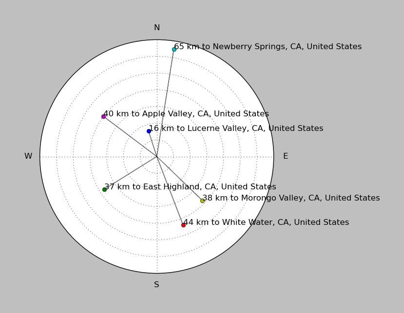
| ||||||||||||||||
Event and active stations
|
|||||||||||||||||
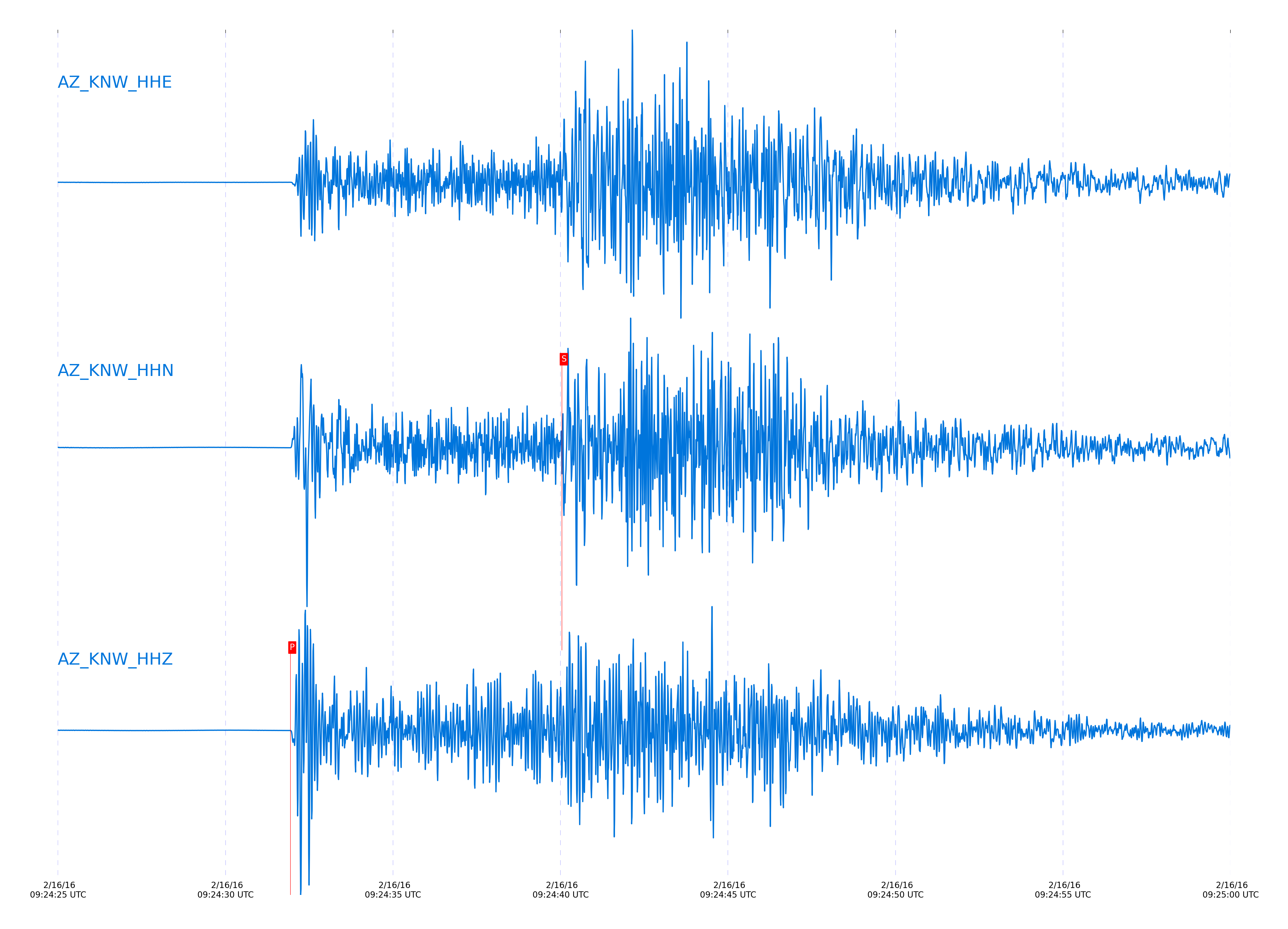
Closest station with identified signal. Not filtered.
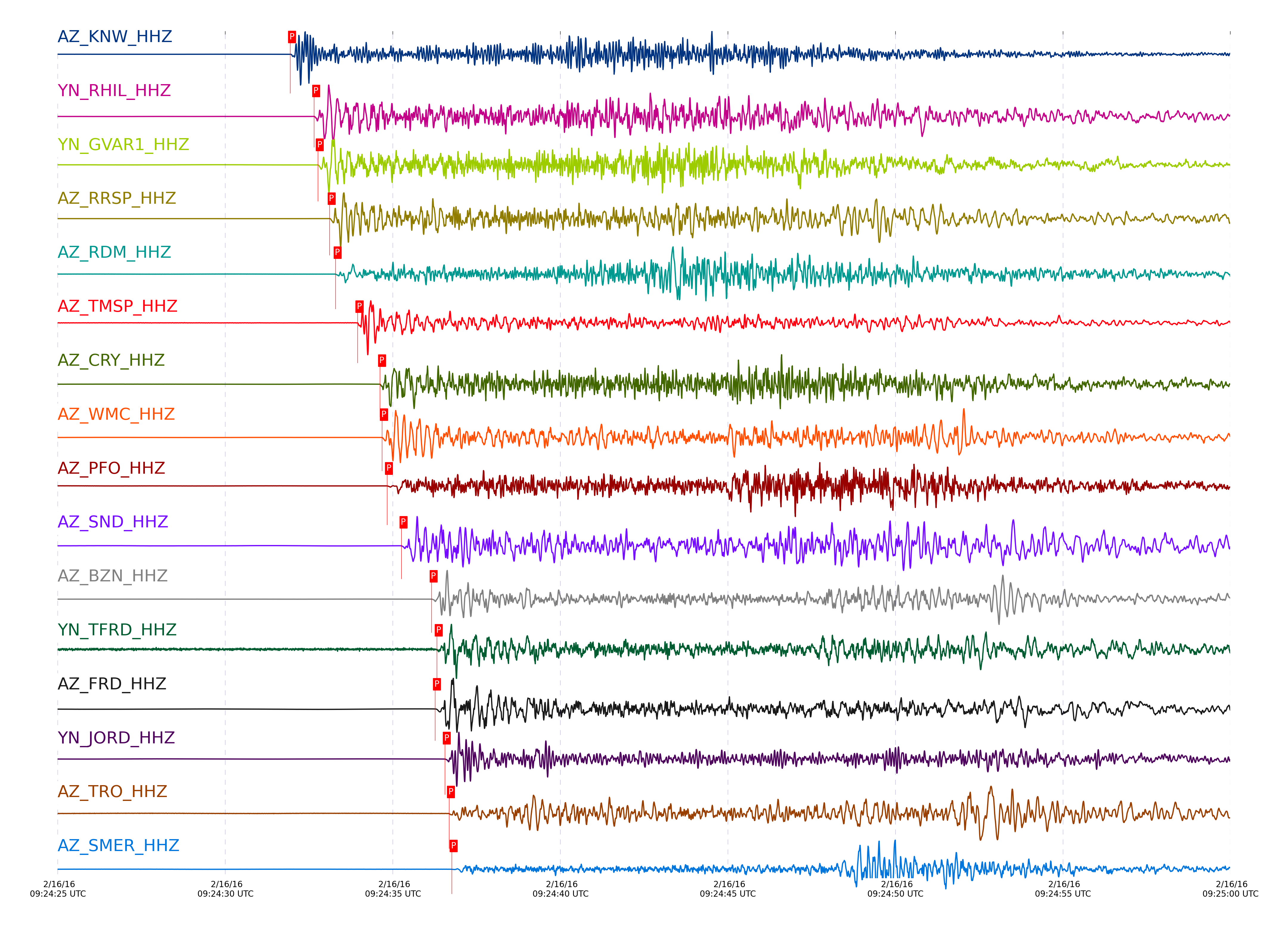
Subset of several stations close to the event. Not filtered.
| STA_CHAN | S-E Delta | S-E Azimuth | Phase | Time | Signal/Noise | Time Residual | V. Model | Auth | arid |
|---|---|---|---|---|---|---|---|---|---|
| KNW_HHZ | 0.603° | 348.07° | Pg | 2016-02-16 09:24:31.935 UTC | 1239.7 | -0.268 | iasp91 | dbp:jtytell:160 | 932825 |
| KNW_HHN | 0.603° | 348.07° | Sg | 2016-02-16 09:24:40.0398 UTC | -1 | -0.565 | iasp91 | dbp:jtytell:160 | 933596 |
| RHIL_HHZ | 0.635° | 353.17° | Pg | 2016-02-16 09:24:32.6532 UTC | -1 | -0.168 | iasp91 | dbp:jtytell:160 | 933536 |
| GVAR1_HHZ | 0.651° | 348.56° | Pg | 2016-02-16 09:24:32.7603 UTC | 1109.1 | -0.355 | iasp91 | dbp:jtytell:160 | 932827 |
| RRSP_HHZ | 0.66° | 351.12° | Pg | 2016-02-16 09:24:33.1158 UTC | -1 | -0.195 | iasp91 | dbp:jtytell:160 | 933540 |
| RDM_HHE | 0.674° | 358.95° | Sg | 2016-02-16 09:24:42.5071 UTC | -1 | -0.449 | iasp91 | dbp:jtytell:160 | 933599 |
| RDM_HHZ | 0.674° | 358.95° | Pg | 2016-02-16 09:24:33.2931 UTC | 96.72 | -0.279 | iasp91 | dbp:jtytell:160 | 932828 |
| TMSP_HHZ | 0.701° | 347.62° | Pg | 2016-02-16 09:24:33.9481 UTC | -1 | -0.144 | iasp91 | dbp:jtytell:160 | 933541 |
| CRY_HHN | 0.746° | 352.01° | Sg | 2016-02-16 09:24:44.6265 UTC | -1 | -0.705 | iasp91 | dbp:jtytell:160 | 933600 |
| CRY_HHZ | 0.746° | 352.01° | Pg | 2016-02-16 09:24:34.6184 UTC | 880.74 | -0.33 | iasp91 | dbp:jtytell:160 | 932830 |
| WMC_HHZ | 0.747° | 347.99° | Pg | 2016-02-16 09:24:34.6784 UTC | 1837.2 | -0.288 | iasp91 | dbp:jtytell:160 | 932831 |
| PFO_HHZ | 0.769° | 334.31° | Pg | 2016-02-16 09:24:34.8258 UTC | 283.12 | -0.564 | iasp91 | dbp:jtytell:160 | 932832 |
| PFO_HHN | 0.769° | 334.31° | Sg | 2016-02-16 09:24:45.0679 UTC | -1 | -1.025 | iasp91 | dbp:jtytell:160 | 933603 |
| SND_HHZ | 0.78° | 344.65° | Pg | 2016-02-16 09:24:35.2604 UTC | 1216.9 | -0.344 | iasp91 | dbp:jtytell:160 | 932833 |
| BZN_HHZ | 0.828° | 348.74° | Pg | 2016-02-16 09:24:36.1587 UTC | 1415.5 | -0.374 | iasp91 | dbp:jtytell:160 | 932835 |
| BZN_HHN | 0.828° | 348.74° | Sg | 2016-02-16 09:24:47.1971 UTC | -1 | -0.869 | iasp91 | dbp:jtytell:160 | 933610 |
| TFRD_HHZ | 0.837° | 345.1° | Pg | 2016-02-16 09:24:36.3126 UTC | -1 | -0.393 | iasp91 | dbp:jtytell:160 | 933556 |
| FRD_HHE | 0.838° | 345.11° | Sg | 2016-02-16 09:24:47.5793 UTC | -1 | -0.789 | iasp91 | dbp:jtytell:160 | 933613 |
| FRD_HHZ | 0.838° | 345.11° | Pg | 2016-02-16 09:24:36.2603 UTC | 1762.9 | -0.447 | iasp91 | dbp:jtytell:160 | 932836 |
| JORD_HHE | 0.851° | 347.79° | Sg | 2016-02-16 09:24:48.0112 UTC | -1 | -0.804 | iasp91 | dbp:jtytell:160 | 933614 |
| JORD_HHZ | 0.851° | 347.79° | Pg | 2016-02-16 09:24:36.5517 UTC | 1811.3 | -0.415 | iasp91 | dbp:jtytell:160 | 932837 |
| TRO_HHN | 0.861° | 335.19° | Sg | 2016-02-16 09:24:48.0905 UTC | -1 | -1.041 | iasp91 | dbp:jtytell:160 | 933616 |
| TRO_HHZ | 0.861° | 335.19° | Pg | 2016-02-16 09:24:36.6784 UTC | 135.56 | -0.471 | iasp91 | dbp:jtytell:160 | 932838 |
| SMER_HHZ | 0.884° | 16.73° | Pg | 2016-02-16 09:24:36.7564 UTC | 143.48 | -0.84 | iasp91 | dbp:jtytell:160 | 932854 |
| SMER_HHE | 0.884° | 16.73° | Sg | 2016-02-16 09:24:48.3989 UTC | -1 | -1.503 | iasp91 | dbp:jtytell:160 | 933615 |
| TR01_HHZ | 0.957° | 337.17° | Pg | 2016-02-16 09:24:38.5395 UTC | 1209.3 | -0.451 | iasp91 | dbp:jtytell:160 | 932856 |
| JFN4_HHZ | 0.959° | 336.56° | Pg | 2016-02-16 09:24:38.4463 UTC | -1 | -0.593 | iasp91 | dbp:jtytell:160 | 933561 |
| TR02_HHZ | 0.96° | 337.43° | Pg | 2016-02-16 09:24:38.5907 UTC | -1 | -0.461 | iasp91 | dbp:jtytell:160 | 933564 |
| JFS4_HHZ | 0.96° | 336.75° | Pg | 2016-02-16 09:24:38.5009 UTC | -1 | -0.561 | iasp91 | dbp:jtytell:160 | 933562 |
| TR03_HHZ | 0.966° | 337.92° | Pg | 2016-02-16 09:24:38.6748 UTC | -1 | -0.493 | iasp91 | dbp:jtytell:160 | 933563 |
| TR03_HHE | 0.966° | 337.92° | Sg | 2016-02-16 09:24:52.1637 UTC | -1 | -0.452 | iasp91 | dbp:jtytell:160 | 933621 |
| TR04_HHZ | 0.975° | 338.28° | Pg | 2016-02-16 09:24:38.9437 UTC | -1 | -0.398 | iasp91 | dbp:jtytell:160 | 933565 |
| TR04_HHE | 0.975° | 338.28° | Sg | 2016-02-16 09:24:53.1084 UTC | -1 | 0.192 | iasp91 | dbp:jtytell:160 | 933625 |
| LVA2_HHZ | 0.985° | 345.36° | Pg | 2016-02-16 09:24:39.0731 UTC | 2124.4 | -0.452 | iasp91 | dbp:jtytell:160 | 932863 |
| LVA2_HHE | 0.985° | 345.36° | Sg | 2016-02-16 09:24:52.1453 UTC | -1 | -1.087 | iasp91 | dbp:jtytell:160 | 933622 |
| CPE_HHZ | 1.429° | 8.05° | Pn | 2016-02-16 09:24:45.7841 UTC | 457.95 | -1.812 | iasp91 | dbp:jtytell:160 | 932867 |
| CPE_HHN | 1.429° | 8.05° | Sn | 2016-02-16 09:25:04.2133 UTC | -1 | -3.672 | iasp91 | dbp:jtytell:160 | 933635 |
| MONP2_HHZ | 1.459° | 345.55° | Pn | 2016-02-16 09:24:47.121 UTC | 375.57 | -0.88 | iasp91 | dbp:jtytell:160 | 932868 |
| SOL_HHZ | 1.498° | 12.27° | Pn | 2016-02-16 09:24:47.2689 UTC | 87.504 | -1.267 | iasp91 | dbp:jtytell:160 | 932872 |
| SOL_HHN | 1.498° | 12.27° | Sn | 2016-02-16 09:25:06.9337 UTC | -1 | -2.643 | iasp91 | dbp:jtytell:160 | 933637 |
Click the link below to observe an interactive map of earthquakes recorded by the station deployment:
Broadband Seismic Data Collection Center (ANZA),
Institute of Geophysics & Planetary Physics
Scripps Institution of Oceanography,
University of California San Diego
Copyright © 1989 - 2014. All Rights Reserved.