
last update to page: March 16 2016 23:26:50 (UTC).
SummaryThe red marker denotes the earthquake epicenter. On Tue Feb 16th 2016 23:04:26 (UTC) the seismic network recorded an earthquake (preliminary 4.77 mw) located in California-nevada Border Region. Seismic region California - Nevada Region. The epicentral distance (i.e. distance separating the location to the epicenter) to the closest station CSLB in the network is 381.9 km. If you felt the quake, the USGS would like to know. Please add your comments to the USGS page "Did you feel it?". |
Details
Proximity to Population Centers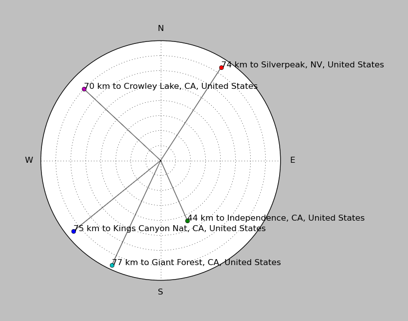
| ||||||||||||||||
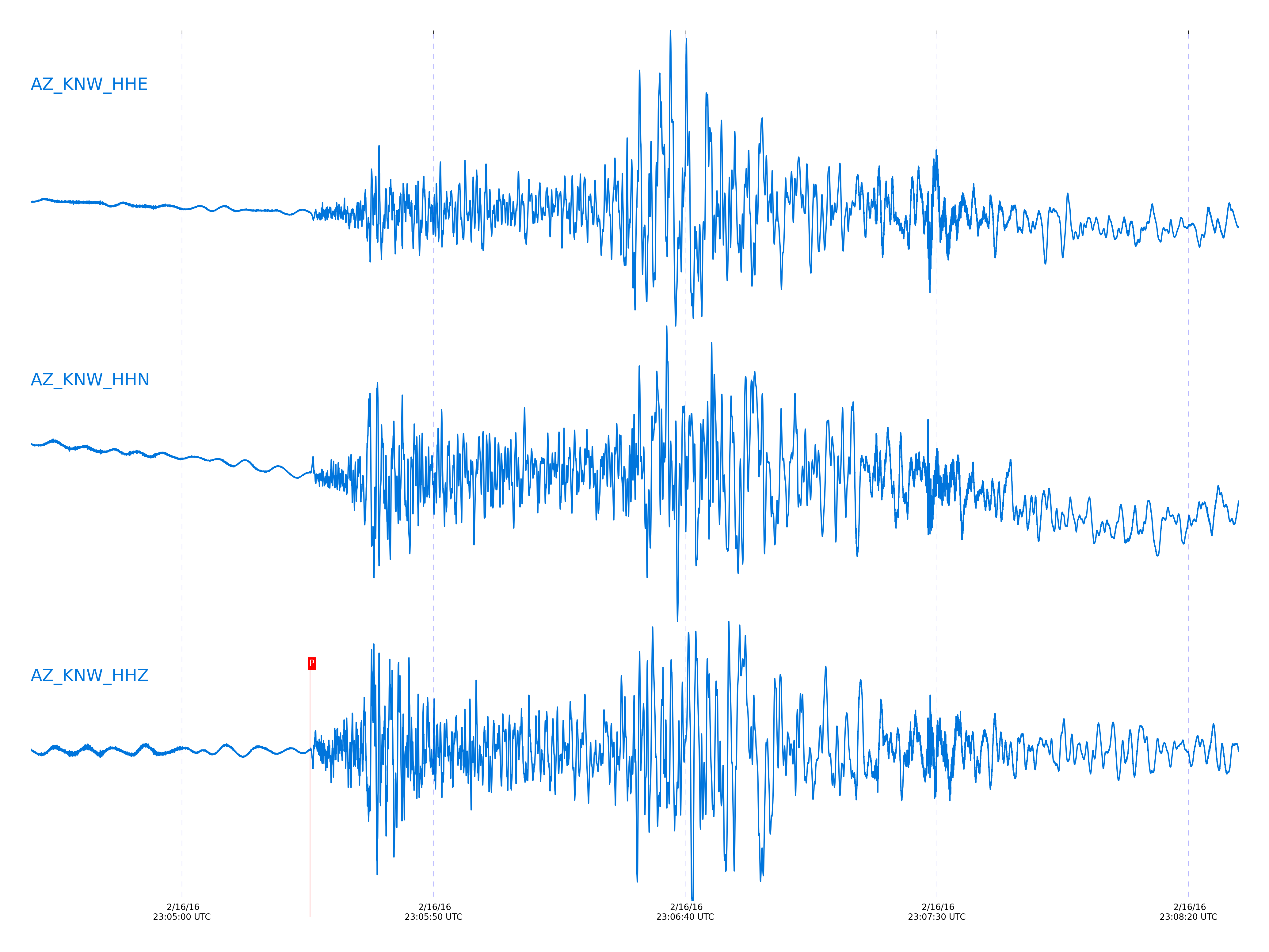
Event and active stations
|
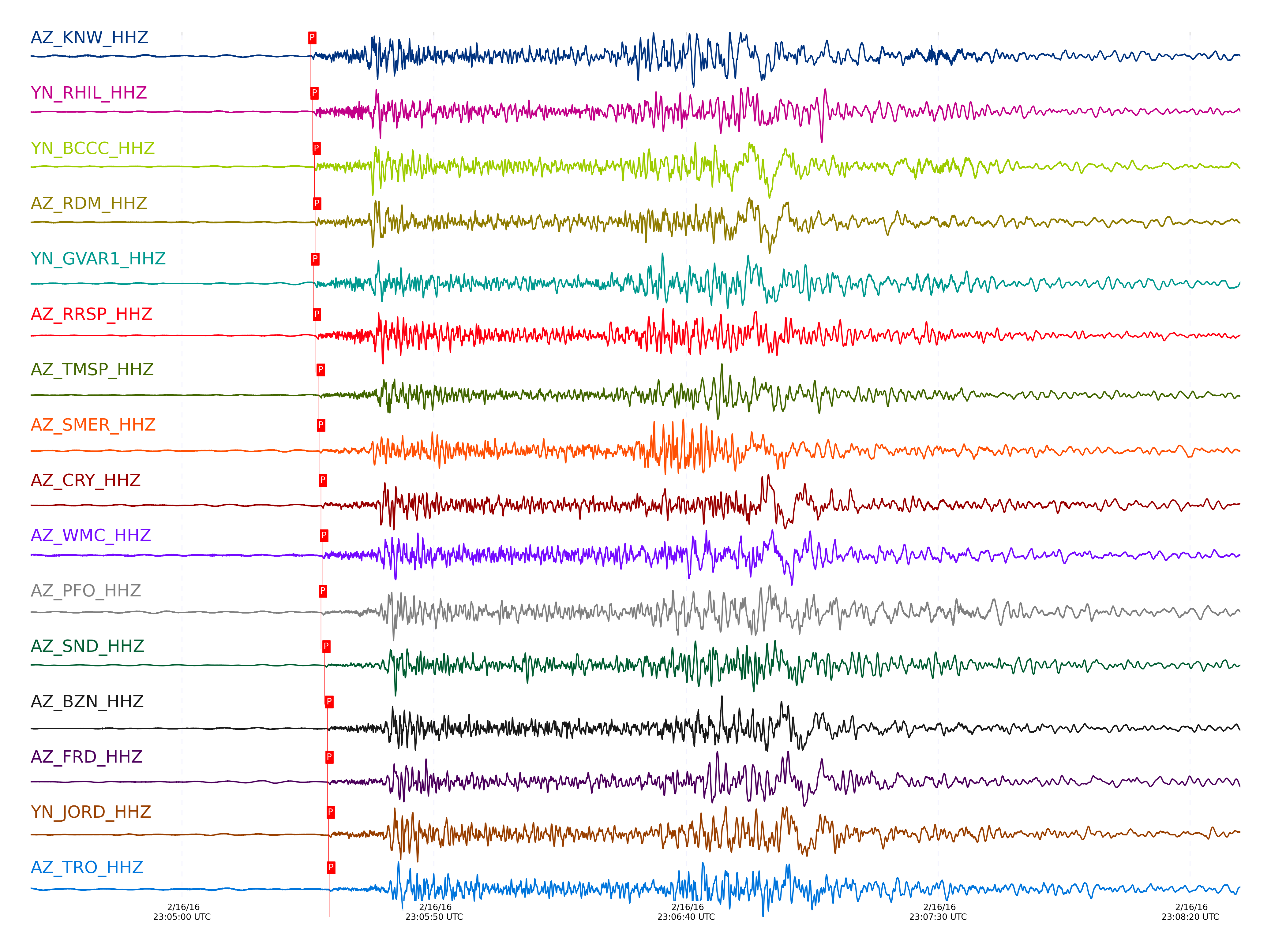
|||||||||||||||||
Closest station with identified signal. Not filtered.
Subset of several stations close to the event. Not filtered.
| STA_CHAN | S-E Delta | S-E Azimuth | Phase | Time | Signal/Noise | Time Residual | V. Model | Auth | arid |
|---|---|---|---|---|---|---|---|---|---|
| KNW_HHZ | 3.75° | 338.93° | Pn | 2016-02-16 23:05:25.4526 UTC | 342.38 | 1.255 | iasp91 | dbp:jtytell:160 | 934319 |
| RHIL_HHZ | 3.771° | 339.82° | Pn | 2016-02-16 23:05:25.9179 UTC | -1 | 1.433 | iasp91 | dbp:jtytell:160 | 934629 |
| BCCC_HHZ | 3.785° | 340.4° | Pn | 2016-02-16 23:05:26.3081 UTC | 18.024 | 1.637 | iasp91 | dbp:jtytell:160 | 934292 |
| RDM_HHZ | 3.79° | 340.91° | Pn | 2016-02-16 23:05:26.4378 UTC | 371.7 | 1.688 | iasp91 | dbp:jtytell:160 | 934325 |
| GVAR1_HHZ | 3.796° | 339.13° | Pn | 2016-02-16 23:05:26.0457 UTC | 73.042 | 1.213 | iasp91 | dbp:jtytell:160 | 934290 |
| RRSP_HHZ | 3.801° | 339.58° | Pn | 2016-02-16 23:05:26.3919 UTC | -1 | 1.501 | iasp91 | dbp:jtytell:160 | 934631 |
| TMSP_HHZ | 3.848° | 339.1° | Pn | 2016-02-16 23:05:27.1365 UTC | -1 | 1.594 | iasp91 | dbp:jtytell:160 | 934632 |
| SMER_HHE | 3.877° | 345.32° | Sb | 2016-02-16 23:06:29.9532 UTC | -1 | 5.139 | iasp91 | dbp:jtytell:160 | 934656 |
| SMER_HHZ | 3.877° | 345.32° | Pn | 2016-02-16 23:05:27.2042 UTC | 277.82 | 1.262 | iasp91 | dbp:jtytell:160 | 934327 |
| CRY_HHN | 3.882° | 340° | Sb | 2016-02-16 23:06:29.9688 UTC | -1 | 5.009 | iasp91 | dbp:jtytell:160 | 934657 |
| CRY_HHZ | 3.882° | 340° | Pn | 2016-02-16 23:05:27.5913 UTC | 20.5 | 1.581 | iasp91 | dbp:jtytell:160 | 934294 |
| WMC_HHZ | 3.893° | 339.27° | Pn | 2016-02-16 23:05:27.8064 UTC | 361.69 | 1.652 | iasp91 | dbp:jtytell:160 | 934331 |
| PFO_HHZ | 3.924° | 336.75° | Pn | 2016-02-16 23:05:27.5947 UTC | 11.192 | 1.003 | iasp91 | dbp:jtytell:160 | 934295 |
| PFO_HHE | 3.924° | 336.75° | Sb | 2016-02-16 23:06:30.5965 UTC | -1 | 4.387 | iasp91 | dbp:jtytell:160 | 934660 |
| SND_HHZ | 3.931° | 338.71° | Pn | 2016-02-16 23:05:28.2438 UTC | 30.554 | 1.557 | iasp91 | dbp:jtytell:160 | 934296 |
| BZN_HHZ | 3.972° | 339.61° | Pn | 2016-02-16 23:05:28.8408 UTC | 352.04 | 1.599 | iasp91 | dbp:jtytell:160 | 934332 |
| FRD_HHZ | 3.988° | 338.9° | Pn | 2016-02-16 23:05:28.8574 UTC | 60.25 | 1.394 | iasp91 | dbp:jtytell:160 | 934297 |
| JORD_HHZ | 3.996° | 339.47° | Pn | 2016-02-16 23:05:29.0955 UTC | 22.139 | 1.517 | iasp91 | dbp:jtytell:160 | 934309 |
| TRO_HHZ | 4.017° | 336.89° | Pn | 2016-02-16 23:05:29.2008 UTC | 278.98 | 1.341 | iasp91 | dbp:jtytell:160 | 934345 |
| TR01_HHZ | 4.113° | 337.32° | Pn | 2016-02-16 23:05:30.3128 UTC | 53.305 | 1.126 | iasp91 | dbp:jtytell:160 | 934312 |
| JFN4_HHZ | 4.116° | 337.18° | Pn | 2016-02-16 23:05:30.3537 UTC | -1 | 1.133 | iasp91 | dbp:jtytell:160 | 934645 |
| TR02_HHZ | 4.116° | 337.38° | Pn | 2016-02-16 23:05:30.3831 UTC | -1 | 1.153 | iasp91 | dbp:jtytell:160 | 934646 |
| JFS4_HHZ | 4.117° | 337.22° | Pn | 2016-02-16 23:05:30.3303 UTC | -1 | 1.093 | iasp91 | dbp:jtytell:160 | 934647 |
| TR03_HHZ | 4.122° | 337.49° | Pn | 2016-02-16 23:05:30.4662 UTC | -1 | 1.153 | iasp91 | dbp:jtytell:160 | 934648 |
| TR04_HHZ | 4.131° | 337.57° | Pn | 2016-02-16 23:05:30.789 UTC | -1 | 1.351 | iasp91 | dbp:jtytell:160 | 934649 |
| LVA2_HHZ | 4.134° | 339.2° | Pn | 2016-02-16 23:05:31.0055 UTC | 17.795 | 1.538 | iasp91 | dbp:jtytell:160 | 934321 |
| CPE_HHZ | 4.442° | 346.53° | Pn | 2016-02-16 23:05:35.2437 UTC | 41.762 | 1.533 | iasp91 | dbp:jtytell:160 | 934356 |
| MONP2_HHZ | 4.605° | 339.94° | Pn | 2016-02-16 23:05:37.3969 UTC | 138.32 | 1.45 | iasp91 | dbp:jtytell:160 | 934365 |
Click the link below to observe an interactive map of earthquakes recorded by the station deployment:
Broadband Seismic Data Collection Center (ANZA),
Institute of Geophysics & Planetary Physics
Scripps Institution of Oceanography,
University of California San Diego
Copyright © 1989 - 2014. All Rights Reserved.