
last update to page: March 31 2016 19:00:49 (UTC).
SummaryThe red marker denotes the earthquake epicenter. On Wed Feb 24th 2016 00:02:23 (UTC) the seismic network recorded an earthquake (preliminary 4.84 mw) located in Central California. Seismic region California - Nevada Region. The epicentral distance (i.e. distance separating the location to the epicenter) to the closest station CSLB in the network is 227.6 km. If you felt the quake, the USGS would like to know. Please add your comments to the USGS page "Did you feel it?". |
Details
Proximity to Population Centers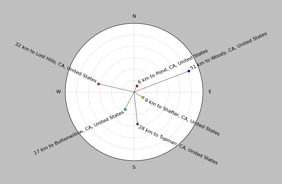
| ||||||||||||||||
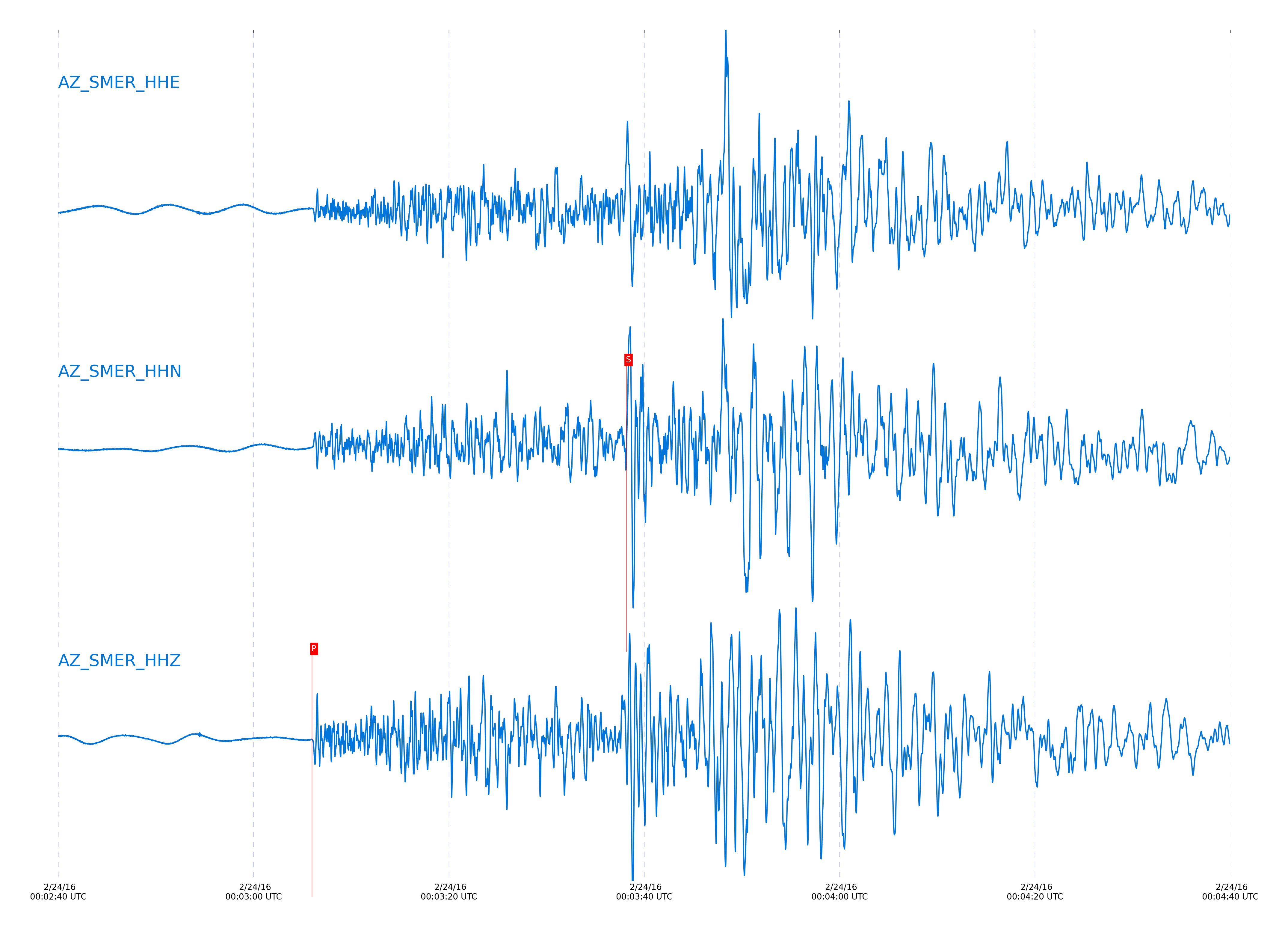
Event and active stations
|
|||||||||||||||||
Closest station with identified signal. Not filtered.
Subset of several stations close to the event. Not filtered.
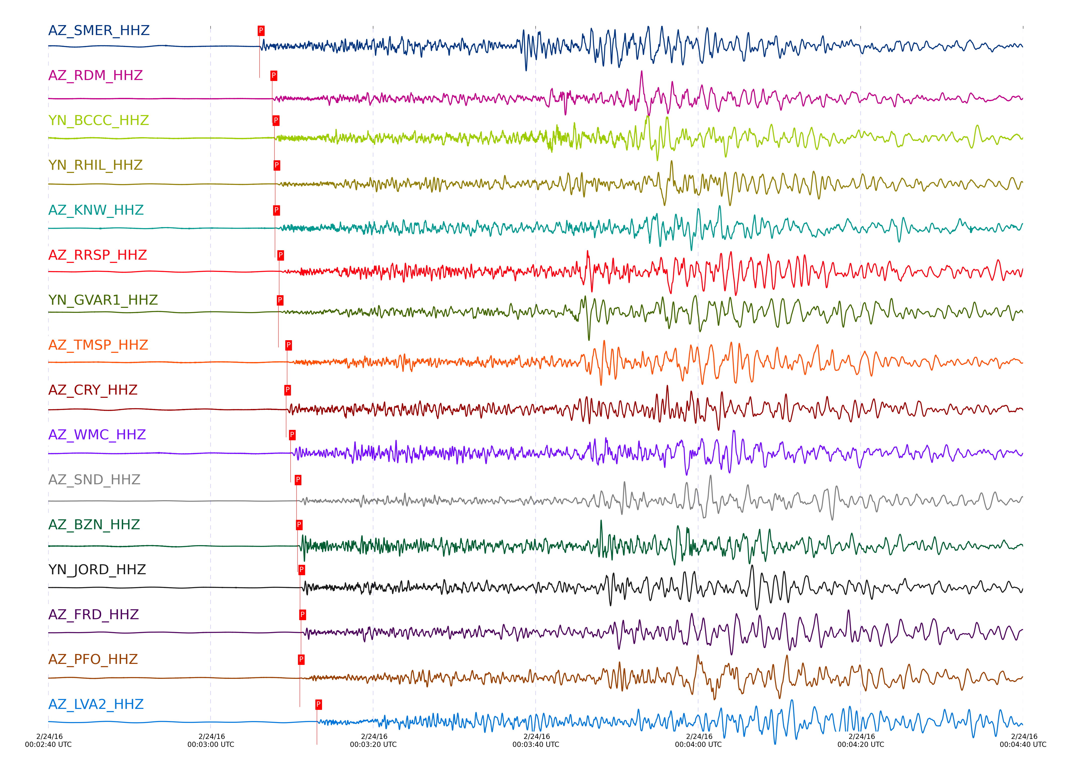
| STA_CHAN | S-E Delta | S-E Azimuth | Phase | Time | Signal/Noise | Time Residual | V. Model | Auth | arid |
|---|---|---|---|---|---|---|---|---|---|
| SMER_HHZ | 2.764° | 319.58° | Pn | 2016-02-24 00:03:06.0059 UTC | 42.096 | -0.56 | iasp91 | dbp:jtytell:160 | 942523 |
| SMER_HHN | 2.764° | 319.58° | Sn | 2016-02-24 00:03:38.1779 UTC | -1 | -1.815 | iasp91 | dbp:jtytell:160 | 942658 |
| RDM_HHN | 2.824° | 313.32° | Sn | 2016-02-24 00:03:41.1903 UTC | -1 | -0.303 | iasp91 | dbp:jtytell:160 | 942659 |
| RDM_HHZ | 2.824° | 313.32° | Pn | 2016-02-24 00:03:07.5656 UTC | 19.748 | 0.165 | iasp91 | dbp:jtytell:160 | 942524 |
| BCCC_HHZ | 2.835° | 312.67° | Pn | 2016-02-24 00:03:07.8429 UTC | 14.449 | 0.29 | iasp91 | dbp:jtytell:160 | 942525 |
| BCCC_HHN | 2.835° | 312.67° | Sn | 2016-02-24 00:03:41.463 UTC | -1 | -0.304 | iasp91 | dbp:jtytell:160 | 942660 |
| RHIL_HHE | 2.842° | 311.85° | Sn | 2016-02-24 00:03:42.3492 UTC | -1 | 0.419 | iasp91 | dbp:jtytell:160 | 942661 |
| RHIL_HHZ | 2.842° | 311.85° | Pn | 2016-02-24 00:03:07.9489 UTC | -1 | 0.306 | iasp91 | dbp:jtytell:160 | 942614 |
| KNW_HHZ | 2.852° | 310.61° | Pn | 2016-02-24 00:03:07.9014 UTC | 27.398 | 0.118 | iasp91 | dbp:jtytell:160 | 942526 |
| KNW_HHN | 2.852° | 310.61° | Sn | 2016-02-24 00:03:42.3926 UTC | -1 | 0.21 | iasp91 | dbp:jtytell:160 | 942662 |
| RRSP_HHZ | 2.876° | 311.84° | Pn | 2016-02-24 00:03:08.4122 UTC | -1 | 0.298 | iasp91 | dbp:jtytell:160 | 942616 |
| RRSP_HHN | 2.876° | 311.84° | Sn | 2016-02-24 00:03:43.4564 UTC | -1 | 0.679 | iasp91 | dbp:jtytell:160 | 942664 |
| GVAR1_HHZ | 2.887° | 311.28° | Pn | 2016-02-24 00:03:08.3467 UTC | -1 | 0.087 | iasp91 | dbp:jtytell:160 | 942617 |
| GVAR1_HHN | 2.887° | 311.28° | Sn | 2016-02-24 00:03:43.1979 UTC | -1 | 0.158 | iasp91 | dbp:jtytell:160 | 942665 |
| TMSP_HHZ | 2.934° | 311.71° | Pn | 2016-02-24 00:03:09.3953 UTC | -1 | 0.486 | iasp91 | dbp:jtytell:160 | 942619 |
| TMSP_HHN | 2.934° | 311.71° | Sn | 2016-02-24 00:03:45.0766 UTC | -1 | 0.869 | iasp91 | dbp:jtytell:160 | 942671 |
| CRY_HHZ | 2.936° | 313.07° | Pn | 2016-02-24 00:03:09.2763 UTC | 216.37 | 0.345 | iasp91 | dbp:jtytell:160 | 942561 |
| CRY_HHE | 2.936° | 313.07° | Sn | 2016-02-24 00:03:44.146 UTC | -1 | -0.1 | iasp91 | dbp:jtytell:160 | 942672 |
| WMC_HHN | 2.968° | 312.3° | Sn | 2016-02-24 00:03:45.4669 UTC | -1 | 0.41 | iasp91 | dbp:jtytell:160 | 942676 |
| WMC_HHZ | 2.968° | 312.3° | Pn | 2016-02-24 00:03:09.8365 UTC | 246.28 | 0.455 | iasp91 | dbp:jtytell:160 | 942562 |
| SND_HHZ | 3.021° | 311.98° | Pn | 2016-02-24 00:03:10.5539 UTC | 138.26 | 0.447 | iasp91 | dbp:jtytell:160 | 942539 |
| SND_HHE | 3.021° | 311.98° | Sn | 2016-02-24 00:03:47.0566 UTC | -1 | 0.695 | iasp91 | dbp:jtytell:160 | 942680 |
| BZN_HHZ | 3.029° | 313.37° | Pn | 2016-02-24 00:03:10.7004 UTC | 211.11 | 0.486 | iasp91 | dbp:jtytell:160 | 942538 |
| BZN_HHE | 3.029° | 313.37° | Sn | 2016-02-24 00:03:46.6974 UTC | -1 | 0.144 | iasp91 | dbp:jtytell:160 | 942681 |
| JORD_HHE | 3.056° | 313.41° | Sn | 2016-02-24 00:03:47.1748 UTC | -1 | -0.036 | iasp91 | dbp:jtytell:160 | 942683 |
| JORD_HHZ | 3.056° | 313.41° | Pn | 2016-02-24 00:03:11.0034 UTC | 72.277 | 0.424 | iasp91 | dbp:jtytell:160 | 942540 |
| FRD_HHZ | 3.066° | 312.67° | Pn | 2016-02-24 00:03:11.1196 UTC | 167.16 | 0.392 | iasp91 | dbp:jtytell:160 | 942541 |
| FRD_HHN | 3.066° | 312.67° | Sn | 2016-02-24 00:03:47.3692 UTC | -1 | -0.108 | iasp91 | dbp:jtytell:160 | 942685 |
| PFO_HHZ | 3.079° | 309.65° | Pn | 2016-02-24 00:03:10.9561 UTC | 52.498 | 0.055 | iasp91 | dbp:jtytell:160 | 942542 |
| PFO_HHE | 3.079° | 309.65° | Sn | 2016-02-24 00:03:48.552 UTC | -1 | 0.764 | iasp91 | dbp:jtytell:160 | 942688 |
| LVA2_HHZ | 3.189° | 314.17° | Pn | 2016-02-24 00:03:13.0831 UTC | 293.55 | 0.664 | iasp91 | dbp:jtytell:160 | 942544 |
| LVA2_HHE | 3.189° | 314.17° | Sn | 2016-02-24 00:03:50.9501 UTC | -1 | 0.431 | iasp91 | dbp:jtytell:160 | 942696 |
| TR01_HHE | 3.231° | 311.82° | Sb | 2016-02-24 00:04:03.2995 UTC | -1 | 1.522 | iasp91 | dbp:jtytell:160 | 942698 |
| TR02_HHZ | 3.232° | 311.91° | Pn | 2016-02-24 00:03:13.439 UTC | -1 | 0.431 | iasp91 | dbp:jtytell:160 | 942632 |
| TR02_HHE | 3.232° | 311.91° | Sb | 2016-02-24 00:04:03.2376 UTC | -1 | 1.43 | iasp91 | dbp:jtytell:160 | 942699 |
| TR03_HHE | 3.234° | 312.08° | Sb | 2016-02-24 00:04:03.4106 UTC | -1 | 1.548 | iasp91 | dbp:jtytell:160 | 942700 |
| JFS4_HHZ | 3.238° | 311.73° | Pn | 2016-02-24 00:03:13.3961 UTC | -1 | 0.314 | iasp91 | dbp:jtytell:160 | 942633 |
| JFN4_HHZ | 3.238° | 311.68° | Pn | 2016-02-24 00:03:13.3999 UTC | -1 | 0.314 | iasp91 | dbp:jtytell:160 | 942634 |
| JFS4_HHE | 3.238° | 311.73° | Sb | 2016-02-24 00:04:03.5013 UTC | -1 | 1.534 | iasp91 | dbp:jtytell:160 | 942702 |
| CPE_HHE | 3.249° | 325.38° | Sb | 2016-02-24 00:04:01.1518 UTC | -1 | -1.151 | iasp91 | dbp:jtytell:160 | 942701 |
| MONP2_HHZ | 3.602° | 318.19° | Pn | 2016-02-24 00:03:18.7521 UTC | 41.241 | 0.661 | iasp91 | dbp:jtytell:160 | 942582 |
Click the link below to observe an interactive map of earthquakes recorded by the station deployment:
Broadband Seismic Data Collection Center (ANZA),
Institute of Geophysics & Planetary Physics
Scripps Institution of Oceanography,
University of California San Diego
Copyright © 1989 - 2014. All Rights Reserved.