
last update to page: March 31 2016 00:37:19 (UTC).
SummaryThe red marker denotes the earthquake epicenter. On Mon Mar 28th 2016 00:03:41 (UTC) the seismic network recorded an earthquake (preliminary 5.1 mb) located in Gulf Of California. Seismic region Baja California And Gulf Of California. The epicentral distance (i.e. distance separating the location to the epicenter) to the closest station USGCB in the network is 357.6 km. If you felt the quake, the USGS would like to know. Please add your comments to the USGS page "Did you feel it?". |
Details
Proximity to Population Centers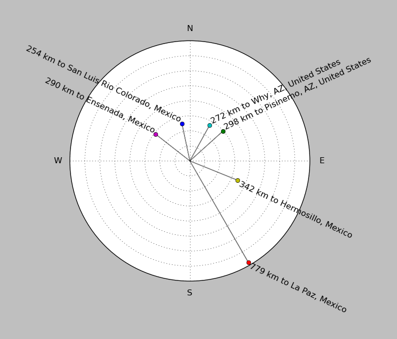
| ||||||||||||||||
Event and active stations
|
|||||||||||||||||
Closest station with identified signal. Not filtered.

Subset of several stations close to the event. Not filtered.
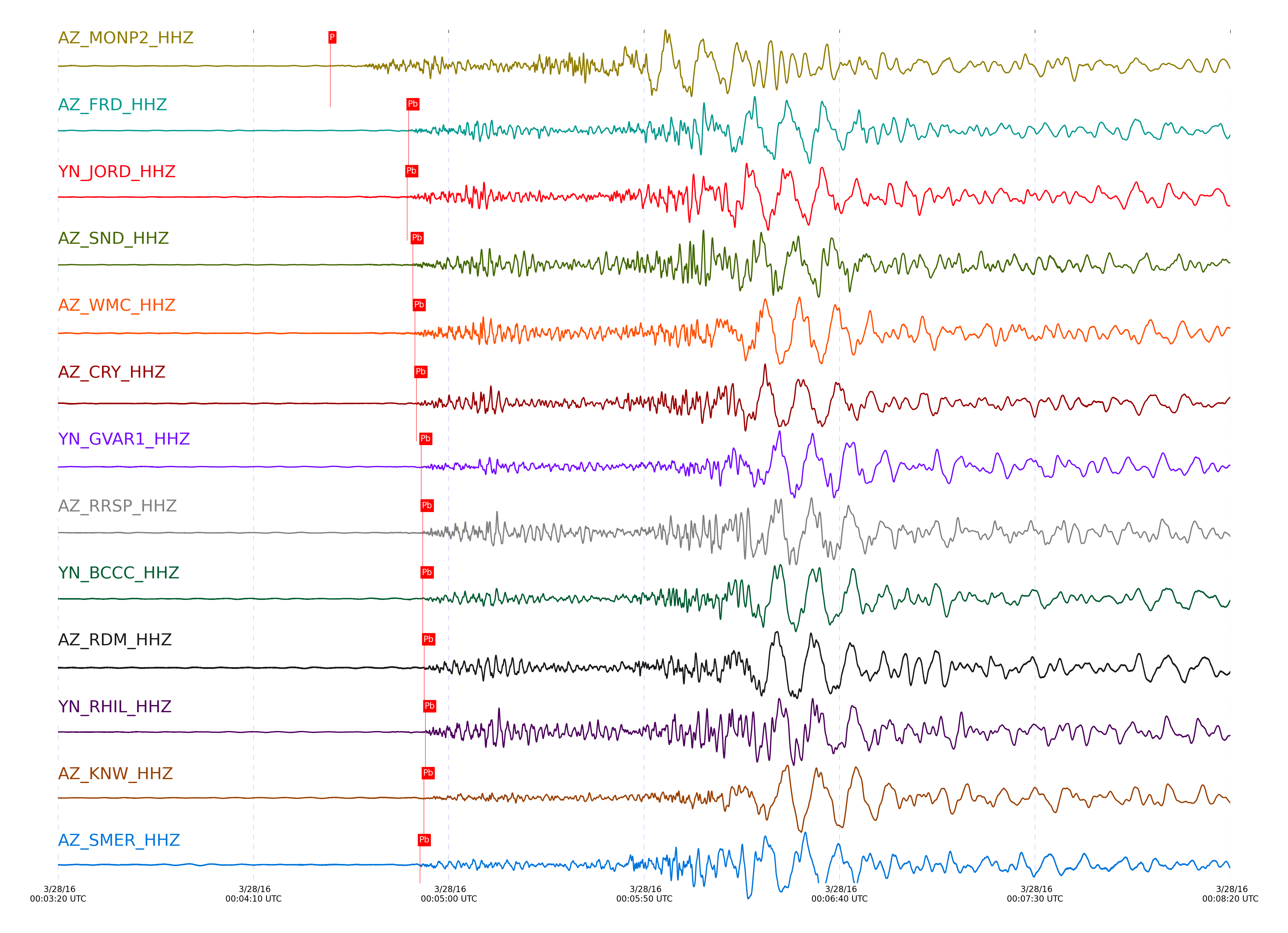
| STA_CHAN | S-E Delta | S-E Azimuth | Phase | Time | Signal/Noise | Time Residual | V. Model | Auth | arid |
|---|---|---|---|---|---|---|---|---|---|
| MONP2_HHZ | 3.248° | 144.53° | Pn | 2016-03-28 00:04:29.7179 UTC | 103.59 | -2.684 | iasp91 | dbp:jtytell:160 | 967468 |
| MONP2_HHN | 3.248° | 144.53° | Sb | 2016-03-28 00:05:21.3756 UTC | -1 | -0.027 | iasp91 | dbp:jtytell:160 | 969780 |
| FRD_HHZ | 3.833° | 147.84° | Pb | 2016-03-28 00:04:49.6878 UTC | 115.38 | 0.573 | iasp91 | dbp:jtytell:160 | 967490 |
| JORD_HHZ | 3.833° | 147.18° | Pb | 2016-03-28 00:04:49.3784 UTC | 130.32 | 0.26 | iasp91 | dbp:jtytell:160 | 967491 |
| SND_HHZ | 3.886° | 148.17° | Pb | 2016-03-28 00:04:50.7577 UTC | 106.86 | 0.736 | iasp91 | dbp:jtytell:160 | 967494 |
| WMC_HHZ | 3.932° | 147.66° | Pb | 2016-03-28 00:04:51.302 UTC | 103.8 | 0.5 | iasp91 | dbp:jtytell:160 | 967474 |
| CRY_HHZ | 3.953° | 146.93° | Pb | 2016-03-28 00:04:51.7073 UTC | -1 | 0.543 | iasp91 | dbp:jtytell:160 | 969769 |
| GVAR1_HHZ | 4.025° | 148.03° | Pb | 2016-03-28 00:04:52.9699 UTC | 51.688 | 0.589 | iasp91 | dbp:jtytell:160 | 967495 |
| RRSP_HHZ | 4.027° | 147.57° | pPb | 2016-03-28 00:04:53.3078 UTC | -1 | -0.681 | iasp91 | dbp:jtytell:160 | 969770 |
| BCCC_HHZ | 4.055° | 146.79° | Pb | 2016-03-28 00:04:53.3022 UTC | -1 | 0.405 | iasp91 | dbp:jtytell:160 | 969773 |
| RDM_HHZ | 4.058° | 146.28° | Pb | 2016-03-28 00:04:53.6809 UTC | -1 | 0.733 | iasp91 | dbp:jtytell:160 | 969771 |
| RHIL_HHZ | 4.059° | 147.4° | pPb | 2016-03-28 00:04:53.9811 UTC | -1 | -0.562 | iasp91 | dbp:jtytell:160 | 969772 |
| KNW_HHZ | 4.068° | 148.33° | Pb | 2016-03-28 00:04:53.5884 UTC | 46.848 | 0.476 | iasp91 | dbp:jtytell:160 | 967496 |
| SMER_HHZ | 4.077° | 141.61° | Pb | 2016-03-28 00:04:52.5912 UTC | 93.899 | -0.683 | iasp91 | dbp:jtytell:160 | 967493 |
| SMER_HHN | 4.077° | 141.61° | Sb | 2016-03-28 00:05:44.9242 UTC | -1 | -0.968 | iasp91 | dbp:jtytell:160 | 969786 |
Click the link below to observe an interactive map of earthquakes recorded by the station deployment:
Broadband Seismic Data Collection Center (ANZA),
Institute of Geophysics & Planetary Physics
Scripps Institution of Oceanography,
University of California San Diego
Copyright © 1989 - 2014. All Rights Reserved.