
last update to page: April 05 2016 21:03:56 (UTC).
SummaryThe red marker denotes the earthquake epicenter. On Sun Apr 3rd 2016 08:23:53 (UTC) the seismic network recorded an earthquake (preliminary 6.9 mww) located in Vanuatu Islands. Seismic region New Hebrides Islands. The epicentral distance (i.e. distance separating the location to the epicenter) to the closest station SCI2 in the network is 9,507.9 km. If you felt the quake, the USGS would like to know. Please add your comments to the USGS page "Did you feel it?". |
Details
Proximity to Population Centers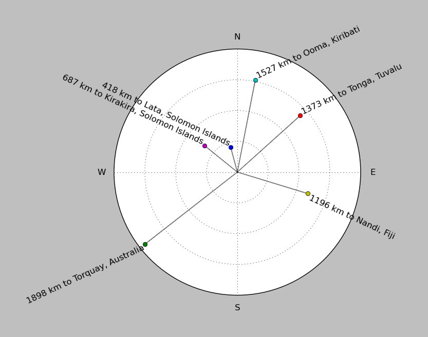
| ||||||||||||||||
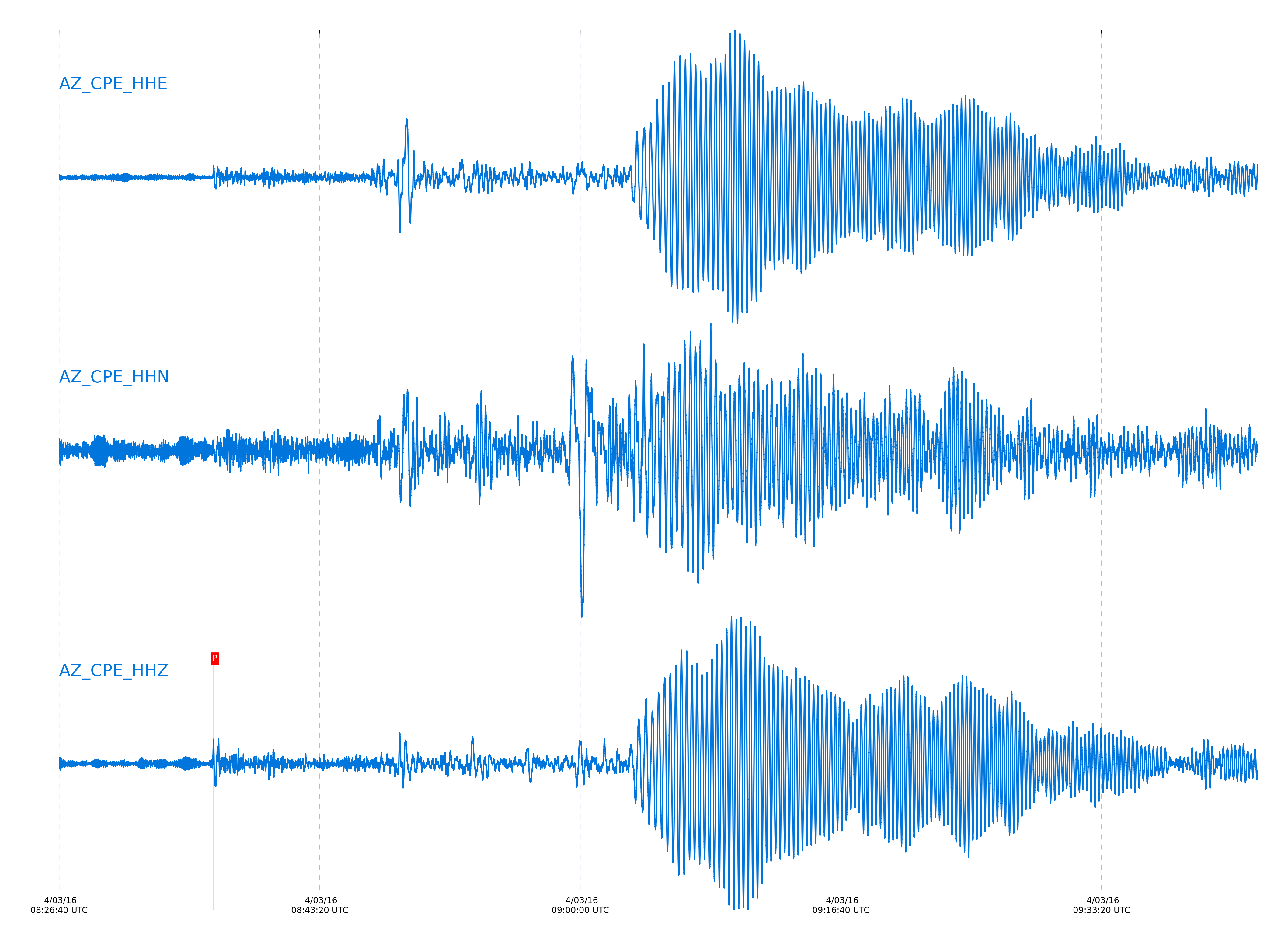
Event and active stations
|
|||||||||||||||||
Closest station with identified signal. Not filtered.
Subset of several stations close to the event. Not filtered.
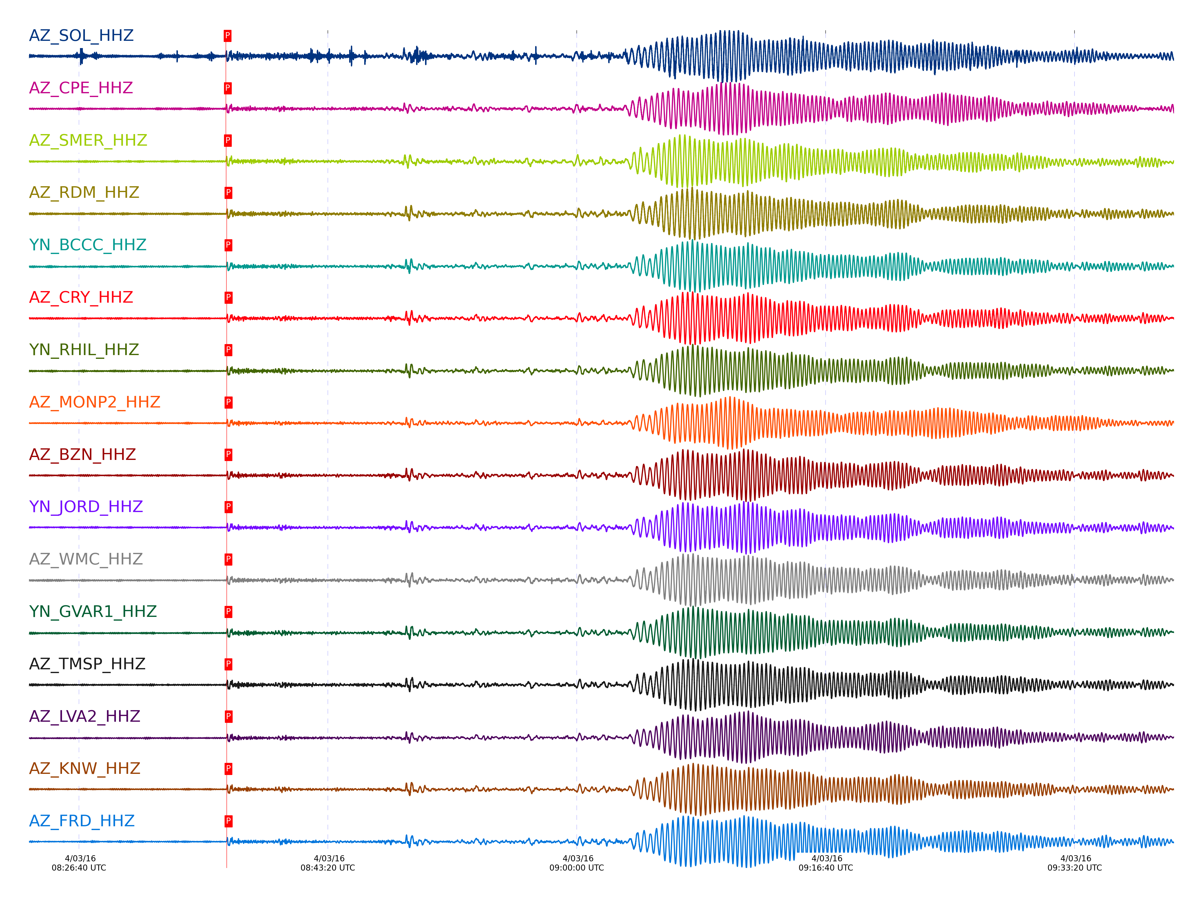
| STA_CHAN | S-E Delta | S-E Azimuth | Phase | Time | Signal/Noise | Time Residual | V. Model | Auth | arid |
|---|---|---|---|---|---|---|---|---|---|
| SOL_HHZ | 86.363° | 250.33° | P | 2016-04-03 08:36:29.8087 UTC | -1 | -2.497 | iasp91 | dbp:jtytell:160 | 974052 |
| CPE_HHZ | 86.492° | 250.4° | P | 2016-04-03 08:36:30.6772 UTC | -1 | -2.262 | iasp91 | dbp:jtytell:160 | 974056 |
| SMER_HHZ | 86.632° | 250.34° | P | 2016-04-03 08:36:31.0058 UTC | -1 | -2.615 | iasp91 | dbp:jtytell:160 | 974060 |
| RDM_HHZ | 86.943° | 250.51° | P | 2016-04-03 08:36:33.464 UTC | 12.64 | -1.673 | iasp91 | dbp:jtytell:160 | 972879 |
| BCCC_HHZ | 86.978° | 250.53° | P | 2016-04-03 08:36:33.1622 UTC | 9.8224 | -2.144 | iasp91 | dbp:jtytell:160 | 972881 |
| CRY_HHZ | 87.008° | 250.58° | P | 2016-04-03 08:36:33.6631 UTC | 10.412 | -1.791 | iasp91 | dbp:jtytell:160 | 972891 |
| RHIL_HHZ | 87.017° | 250.55° | P | 2016-04-03 08:36:33.3547 UTC | -1 | -2.144 | iasp91 | dbp:jtytell:160 | 974071 |
| MONP2_HHZ | 87.034° | 250.79° | P | 2016-04-03 08:36:33.6709 UTC | 9.0629 | -1.909 | iasp91 | dbp:jtytell:160 | 972895 |
| BZN_HHZ | 87.039° | 250.62° | P | 2016-04-03 08:36:33.5768 UTC | 8.3397 | -2.026 | iasp91 | dbp:jtytell:160 | 972887 |
| JORD_HHZ | 87.05° | 250.63° | P | 2016-04-03 08:36:33.6296 UTC | 8.7637 | -2.026 | iasp91 | dbp:jtytell:160 | 972889 |
| WMC_HHZ | 87.06° | 250.61° | P | 2016-04-03 08:36:33.4442 UTC | 8.9182 | -2.262 | iasp91 | dbp:jtytell:160 | 972885 |
| GVAR1_HHZ | 87.066° | 250.59° | P | 2016-04-03 08:36:33.4719 UTC | -1 | -2.262 | iasp91 | dbp:jtytell:160 | 974075 |
| TMSP_HHZ | 87.07° | 250.6° | P | 2016-04-03 08:36:33.2586 UTC | -1 | -2.497 | iasp91 | dbp:jtytell:160 | 974076 |
| LVA2_HHZ | 87.076° | 250.69° | P | 2016-04-03 08:36:33.8724 UTC | 8.8324 | -1.909 | iasp91 | dbp:jtytell:160 | 972883 |
| KNW_HHZ | 87.078° | 250.58° | P | 2016-04-03 08:36:33.2935 UTC | 9.7435 | -2.497 | iasp91 | dbp:jtytell:160 | 972897 |
| FRD_HHZ | 87.091° | 250.66° | P | 2016-04-03 08:36:33.8288 UTC | 8.3164 | -2.026 | iasp91 | dbp:jtytell:160 | 972893 |
| SND_HHZ | 87.102° | 250.65° | P | 2016-04-03 08:36:33.6445 UTC | -1 | -2.262 | iasp91 | dbp:jtytell:160 | 974078 |
| TR04_HHZ | 87.198° | 250.76° | P | 2016-04-03 08:36:34.228 UTC | -1 | -2.145 | iasp91 | dbp:jtytell:160 | 974084 |
| TR03_HHZ | 87.204° | 250.76° | P | 2016-04-03 08:36:34.1711 UTC | -1 | -2.229 | iasp91 | dbp:jtytell:160 | 974086 |
| TR02_HHZ | 87.212° | 250.76° | P | 2016-04-03 08:36:34.2097 UTC | -1 | -2.229 | iasp91 | dbp:jtytell:160 | 974087 |
| TR01_HHZ | 87.216° | 250.77° | P | 2016-04-03 08:36:34.2296 UTC | -1 | -2.229 | iasp91 | dbp:jtytell:160 | 974088 |
| JFS4_HHZ | 87.223° | 250.77° | P | 2016-04-03 08:36:34.434 UTC | -1 | -2.06 | iasp91 | dbp:jtytell:160 | 974090 |
| JFN4_HHZ | 87.226° | 250.77° | P | 2016-04-03 08:36:34.4486 UTC | -1 | -2.06 | iasp91 | dbp:jtytell:160 | 974091 |
| TRO_HHZ | 87.239° | 250.75° | P | 2016-04-03 08:36:34.6798 UTC | 9.177 | -1.892 | iasp91 | dbp:jtytell:160 | 972876 |
| PFO_HHZ | 87.242° | 250.73° | P | 2016-04-03 08:36:34.524 UTC | -1 | -2.06 | iasp91 | dbp:jtytell:160 | 974095 |
Click the link below to observe an interactive map of earthquakes recorded by the station deployment:
Broadband Seismic Data Collection Center (ANZA),
Institute of Geophysics & Planetary Physics
Scripps Institution of Oceanography,
University of California San Diego
Copyright © 1989 - 2014. All Rights Reserved.