
last update to page: April 06 2016 17:01:10 (UTC).
SummaryThe red marker denotes the earthquake epicenter. On Wed Apr 6th 2016 06:58:50 (UTC) the seismic network recorded an earthquake (preliminary 6.9 mwp) located in Vanuatu Islands. Seismic region New Hebrides Islands. The epicentral distance (i.e. distance separating the location to the epicenter) to the closest station SCI2 in the network is 9,514.4 km. If you felt the quake, the USGS would like to know. Please add your comments to the USGS page "Did you feel it?". |
Details
Proximity to Population Centers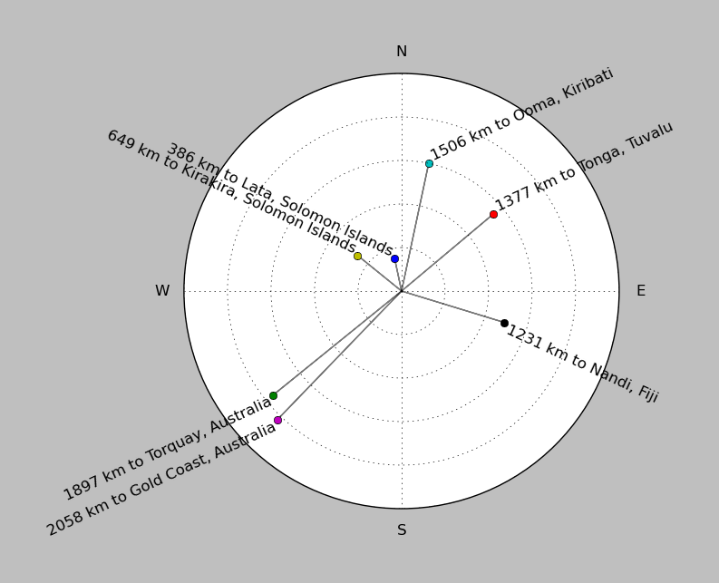
| ||||||||||||||||
Event and active stations
|
|||||||||||||||||
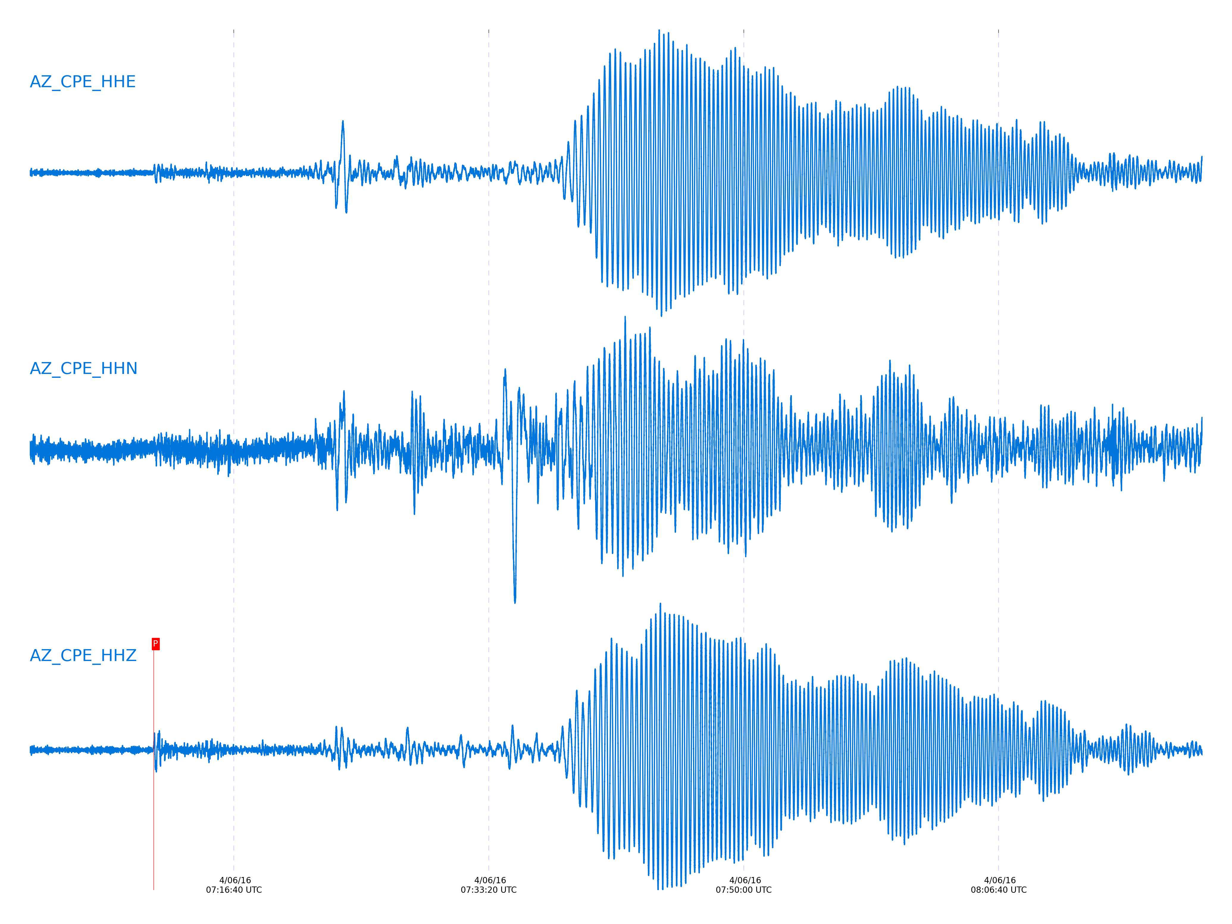
Closest station with identified signal. Not filtered.
Subset of several stations close to the event. Not filtered.
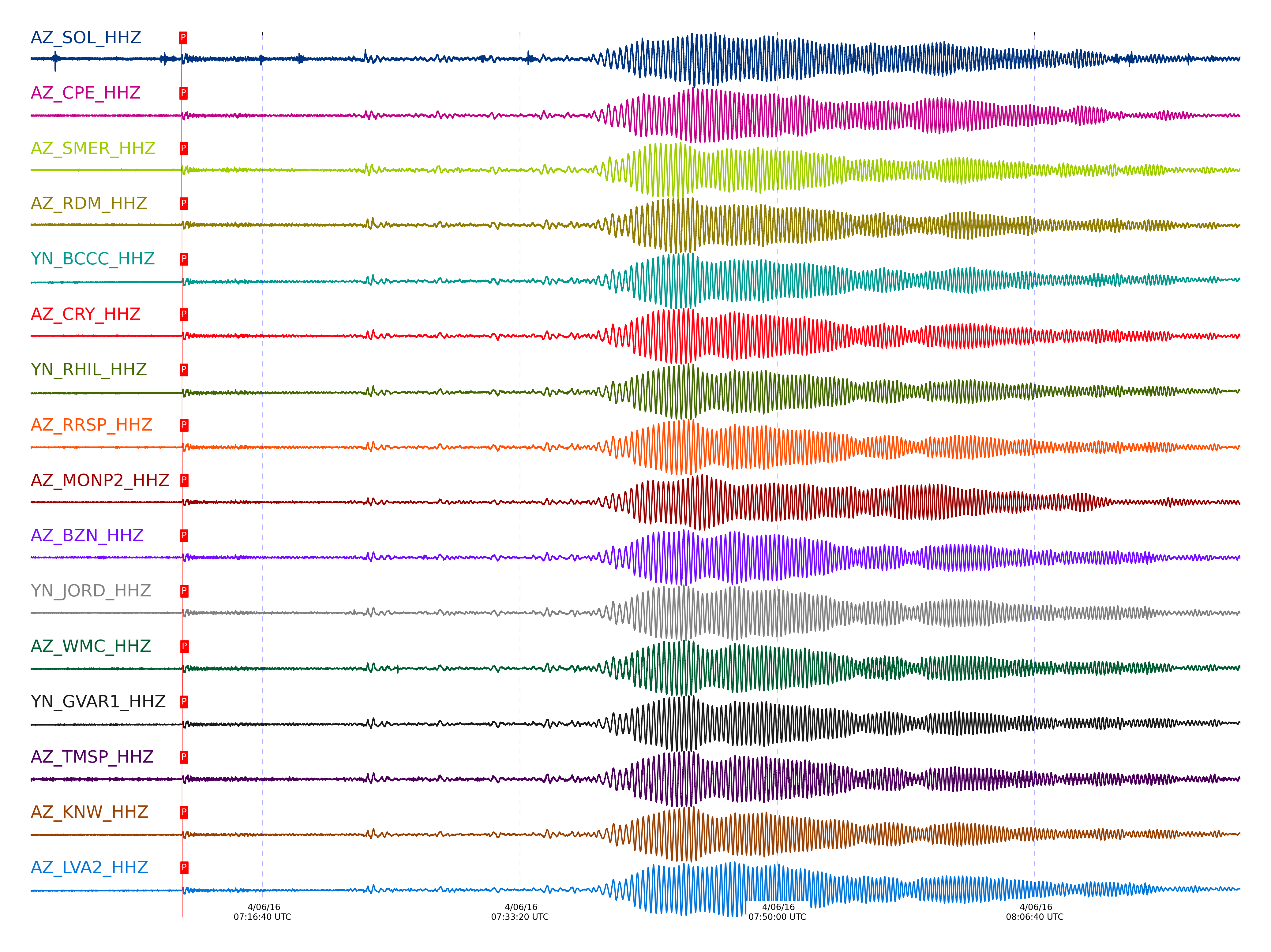
| STA_CHAN | S-E Delta | S-E Azimuth | Phase | Time | Signal/Noise | Time Residual | V. Model | Auth | arid |
|---|---|---|---|---|---|---|---|---|---|
| SOL_HHZ | 86.424° | 250.67° | P | 2016-04-06 07:11:24.5824 UTC | -1 | -4.662 | iasp91 | dbp:jtytell:160 | 976035 |
| CPE_HHZ | 86.553° | 250.74° | P | 2016-04-06 07:11:25.7501 UTC | 8.7139 | -4.127 | iasp91 | dbp:jtytell:160 | 975692 |
| SMER_HHZ | 86.689° | 250.68° | P | 2016-04-06 07:11:26.629 UTC | 9.6928 | -3.913 | iasp91 | dbp:jtytell:160 | 975690 |
| RDM_HHZ | 87° | 250.85° | P | 2016-04-06 07:11:27.8211 UTC | 10.507 | -4.234 | iasp91 | dbp:jtytell:160 | 975698 |
| BCCC_HHZ | 87.035° | 250.87° | P | 2016-04-06 07:11:28.3106 UTC | 8.9435 | -3.913 | iasp91 | dbp:jtytell:160 | 975706 |
| CRY_HHZ | 87.066° | 250.92° | P | 2016-04-06 07:11:28.1401 UTC | 8.5335 | -4.234 | iasp91 | dbp:jtytell:160 | 975704 |
| RHIL_HHZ | 87.074° | 250.89° | P | 2016-04-06 07:11:27.8602 UTC | -1 | -4.555 | iasp91 | dbp:jtytell:160 | 976047 |
| RRSP_HHZ | 87.092° | 250.91° | P | 2016-04-06 07:11:28.6966 UTC | -1 | -3.806 | iasp91 | dbp:jtytell:160 | 976049 |
| MONP2_HHZ | 87.096° | 251.12° | P | 2016-04-06 07:11:29.0354 UTC | 10.48 | -3.485 | iasp91 | dbp:jtytell:160 | 975713 |
| BZN_HHZ | 87.097° | 250.96° | P | 2016-04-06 07:11:28.1844 UTC | 10.05 | -4.341 | iasp91 | dbp:jtytell:160 | 975694 |
| JORD_HHZ | 87.108° | 250.97° | P | 2016-04-06 07:11:28.9871 UTC | 10.999 | -3.592 | iasp91 | dbp:jtytell:160 | 975701 |
| WMC_HHZ | 87.118° | 250.95° | P | 2016-04-06 07:11:29.6761 UTC | 8.4006 | -2.95 | iasp91 | dbp:jtytell:160 | 975711 |
| GVAR1_HHZ | 87.123° | 250.93° | P | 2016-04-06 07:11:28.4167 UTC | -1 | -4.234 | iasp91 | dbp:jtytell:160 | 976052 |
| TMSP_HHZ | 87.128° | 250.94° | P | 2016-04-06 07:11:27.6908 UTC | -1 | -4.983 | iasp91 | dbp:jtytell:160 | 976053 |
| KNW_HHZ | 87.135° | 250.92° | P | 2016-04-06 07:11:28.365 UTC | 11.835 | -4.341 | iasp91 | dbp:jtytell:160 | 975714 |
| LVA2_HHZ | 87.135° | 251.03° | P | 2016-04-06 07:11:29.116 UTC | 15.453 | -3.592 | iasp91 | dbp:jtytell:160 | 975702 |
| FRD_HHZ | 87.149° | 251° | P | 2016-04-06 07:11:28.6506 UTC | 9.6554 | -4.127 | iasp91 | dbp:jtytell:160 | 975696 |
| SND_HHZ | 87.16° | 250.99° | P | 2016-04-06 07:11:29.7702 UTC | -1 | -3.057 | iasp91 | dbp:jtytell:160 | 976055 |
| TR04_HHZ | 87.257° | 251.1° | P | 2016-04-06 07:11:29.4923 UTC | -1 | -3.806 | iasp91 | dbp:jtytell:160 | 976062 |
| TR03_HHZ | 87.263° | 251.1° | P | 2016-04-06 07:11:29.7334 UTC | -1 | -3.592 | iasp91 | dbp:jtytell:160 | 976063 |
| TR02_HHZ | 87.271° | 251.1° | P | 2016-04-06 07:11:29.986 UTC | -1 | -3.378 | iasp91 | dbp:jtytell:160 | 976065 |
| TR01_HHZ | 87.275° | 251.11° | P | 2016-04-06 07:11:29.7915 UTC | 7.8776 | -3.592 | iasp91 | dbp:jtytell:160 | 975720 |
| JFS4_HHZ | 87.282° | 251.11° | P | 2016-04-06 07:11:30.2557 UTC | -1 | -3.164 | iasp91 | dbp:jtytell:160 | 976067 |
| JFN4_HHZ | 87.285° | 251.11° | P | 2016-04-06 07:11:30.0562 UTC | -1 | -3.378 | iasp91 | dbp:jtytell:160 | 976068 |
| PFO_HHZ | 87.3° | 251.07° | P | 2016-04-06 07:11:30.34 UTC | -1 | -3.164 | iasp91 | dbp:jtytell:160 | 976073 |
Click the link below to observe an interactive map of earthquakes recorded by the station deployment:
Broadband Seismic Data Collection Center (ANZA),
Institute of Geophysics & Planetary Physics
Scripps Institution of Oceanography,
University of California San Diego
Copyright © 1989 - 2014. All Rights Reserved.