
last update to page: April 17 2016 01:59:49 (UTC).
SummaryThe red marker denotes the earthquake epicenter. On Sat Apr 16th 2016 23:58:37 (UTC) the seismic network recorded an earthquake (preliminary 7.8 mww) located in Near Coast Of Ecuador. Seismic region Andean South America. The epicentral distance (i.e. distance separating the location to the epicenter) to the closest station USGCB in the network is 5,244.8 km. If you felt the quake, the USGS would like to know. Please add your comments to the USGS page "Did you feel it?". |
Details
Proximity to Population Centers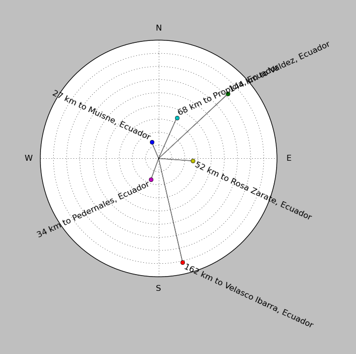
| ||||||||||||||||
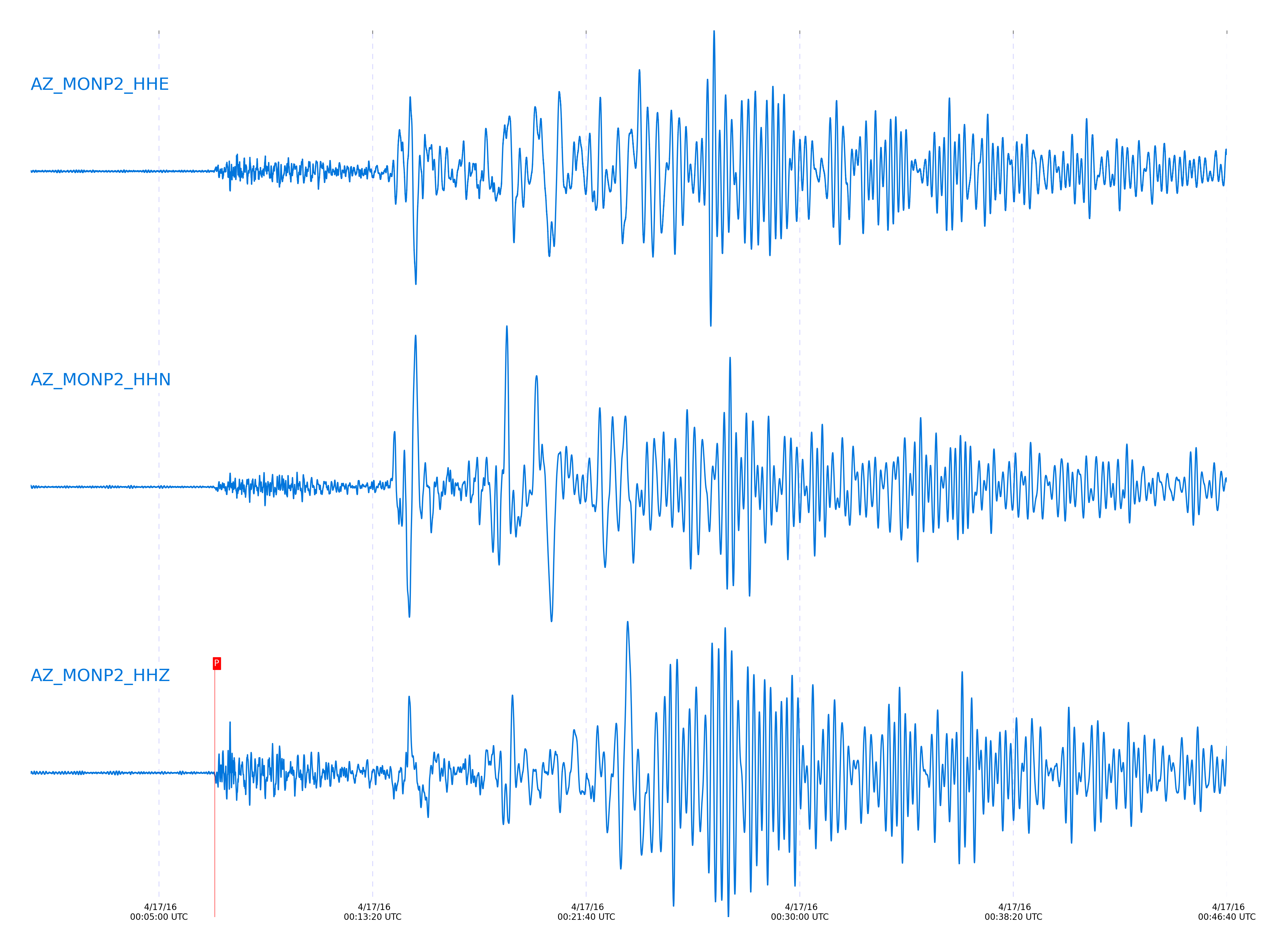
Event and active stations
|
|||||||||||||||||
Closest station with identified signal. Not filtered.
Subset of several stations close to the event. Not filtered.
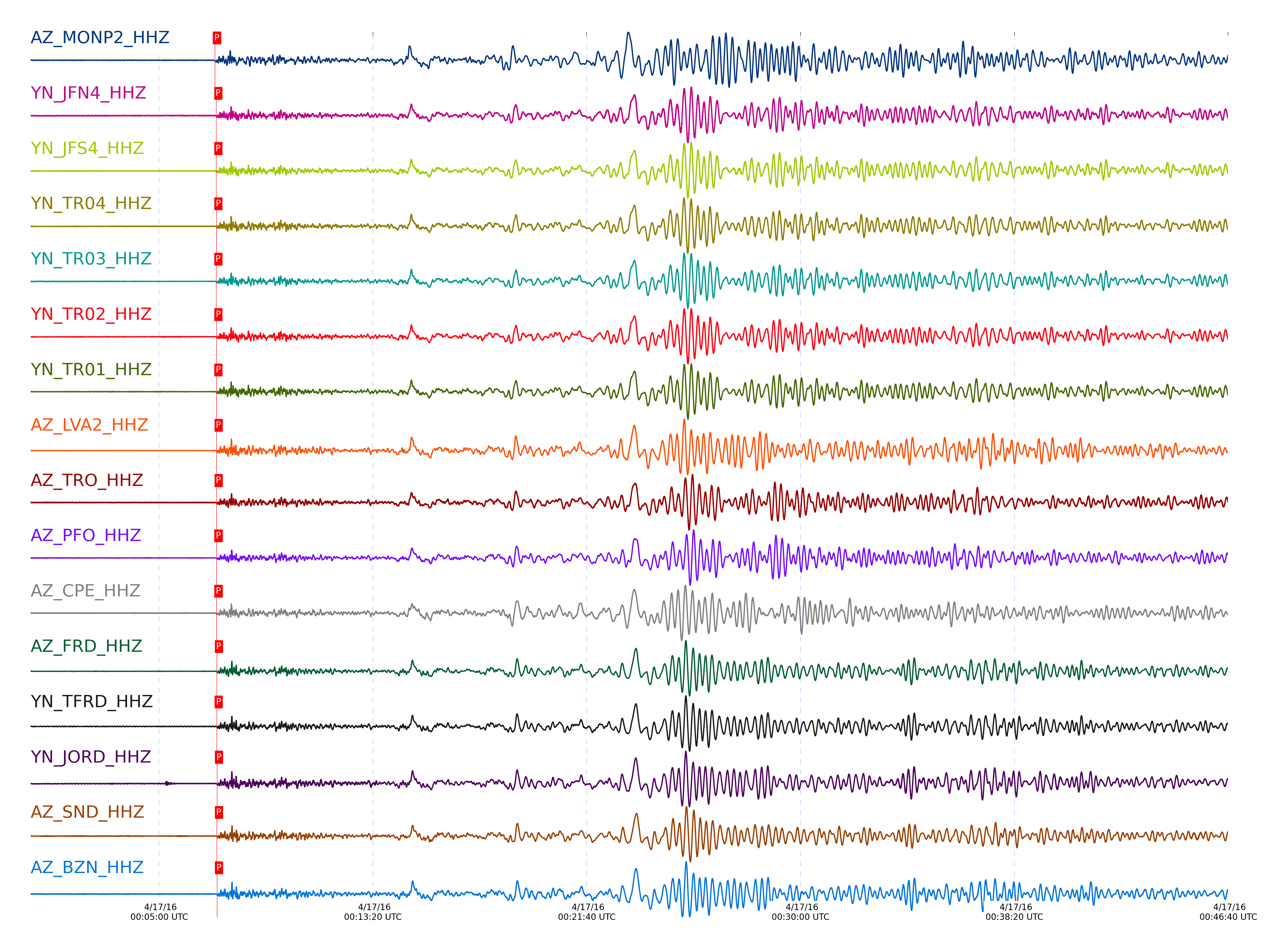
| STA_CHAN | S-E Delta | S-E Azimuth | Phase | Time | Signal/Noise | Time Residual | V. Model | Auth | arid |
|---|---|---|---|---|---|---|---|---|---|
| MONP2_HHZ | 47.261° | 125.95° | P | 2016-04-17 00:07:10.7893 UTC | 24.967 | 1.731 | iasp91 | dbp:jtytell:161 | 985289 |
| JFN4_HHZ | 47.561° | 126.37° | P | 2016-04-17 00:07:13.9882 UTC | -1 | 2.597 | iasp91 | dbp:jtytell:161 | 985326 |
| JFS4_HHZ | 47.562° | 126.36° | P | 2016-04-17 00:07:13.7891 UTC | -1 | 2.393 | iasp91 | dbp:jtytell:161 | 985327 |
| TR04_HHZ | 47.563° | 126.32° | P | 2016-04-17 00:07:14.2042 UTC | -1 | 2.8 | iasp91 | dbp:jtytell:161 | 985328 |
| TR03_HHZ | 47.567° | 126.33° | P | 2016-04-17 00:07:13.8321 UTC | -1 | 2.393 | iasp91 | dbp:jtytell:161 | 985329 |
| TR02_HHZ | 47.568° | 126.35° | P | 2016-04-17 00:07:14.2459 UTC | -1 | 2.8 | iasp91 | dbp:jtytell:161 | 985330 |
| TR01_HHZ | 47.569° | 126.35° | P | 2016-04-17 00:07:14.1481 UTC | 42.555 | 2.698 | iasp91 | dbp:jtytell:161 | 985295 |
| LVA2_HHZ | 47.626° | 126.15° | P | 2016-04-17 00:07:14.6456 UTC | 73.762 | 2.749 | iasp91 | dbp:jtytell:161 | 985288 |
| TRO_HHZ | 47.636° | 126.41° | P | 2016-04-17 00:07:14.7259 UTC | 71.617 | 2.749 | iasp91 | dbp:jtytell:161 | 985292 |
| PFO_HHZ | 47.711° | 126.45° | P | 2016-04-17 00:07:14.4429 UTC | -1 | 1.884 | iasp91 | dbp:jtytell:161 | 985342 |
| CPE_HHZ | 47.726° | 125.27° | P | 2016-04-17 00:07:14.4008 UTC | -1 | 1.731 | iasp91 | dbp:jtytell:161 | 985344 |
| FRD_HHZ | 47.738° | 126.22° | P | 2016-04-17 00:07:15.3109 UTC | 55.22 | 2.546 | iasp91 | dbp:jtytell:161 | 985291 |
| TFRD_HHZ | 47.738° | 126.22° | P | 2016-04-17 00:07:14.8531 UTC | -1 | 2.087 | iasp91 | dbp:jtytell:161 | 985346 |
| JORD_HHZ | 47.754° | 126.16° | P | 2016-04-17 00:07:15.5332 UTC | 65.34 | 2.647 | iasp91 | dbp:jtytell:161 | 985296 |
| SND_HHZ | 47.779° | 126.25° | P | 2016-04-17 00:07:15.3235 UTC | -1 | 2.24 | iasp91 | dbp:jtytell:161 | 985349 |
| BZN_HHZ | 47.78° | 126.15° | P | 2016-04-17 00:07:15.5837 UTC | 43.532 | 2.495 | iasp91 | dbp:jtytell:161 | 985298 |
| WMC_HHZ | 47.833° | 126.2° | P | 2016-04-17 00:07:15.3379 UTC | -1 | 1.833 | iasp91 | dbp:jtytell:161 | 985353 |
| TMSP_HHZ | 47.865° | 126.23° | P | 2016-04-17 00:07:16.2918 UTC | -1 | 2.546 | iasp91 | dbp:jtytell:161 | 985354 |
| CRY_HHZ | 47.871° | 126.13° | P | 2016-04-17 00:07:16.1869 UTC | 57.58 | 2.393 | iasp91 | dbp:jtytell:161 | 985297 |
| GVAR1_HHZ | 47.91° | 126.24° | P | 2016-04-17 00:07:16.6413 UTC | -1 | 2.546 | iasp91 | dbp:jtytell:161 | 985357 |
| RRSP_HHZ | 47.923° | 126.19° | P | 2016-04-17 00:07:16.7951 UTC | -1 | 2.597 | iasp91 | dbp:jtytell:161 | 985359 |
| KNW_HHZ | 47.941° | 126.27° | P | 2016-04-17 00:07:16.8878 UTC | -1 | 2.546 | iasp91 | dbp:jtytell:161 | 985360 |
| RHIL_HHZ | 47.957° | 126.18° | P | 2016-04-17 00:07:17.0604 UTC | -1 | 2.597 | iasp91 | dbp:jtytell:161 | 985362 |
| BCCC_HHZ | 47.968° | 126.12° | P | 2016-04-17 00:07:16.2798 UTC | -1 | 1.731 | iasp91 | dbp:jtytell:161 | 985364 |
| RDM_HHZ | 47.983° | 126.07° | P | 2016-04-17 00:07:16.0905 UTC | -1 | 1.426 | iasp91 | dbp:jtytell:161 | 985365 |
| SMER_HHZ | 48.1° | 125.62° | P | 2016-04-17 00:07:17.4056 UTC | -1 | 1.833 | iasp91 | dbp:jtytell:161 | 985368 |
Click the link below to observe an interactive map of earthquakes recorded by the station deployment:
Broadband Seismic Data Collection Center (ANZA),
Institute of Geophysics & Planetary Physics
Scripps Institution of Oceanography,
University of California San Diego
Copyright © 1989 - 2014. All Rights Reserved.