
last update to page: January 23 2018 19:14:59 (UTC).
SummaryThe red marker denotes the earthquake epicenter. On Tue Jan 23rd 2018 09:31:42 (UTC) the seismic network recorded an earthquake (preliminary 7.9 mww) located in Gulf Of Alaska. Seismic region Alaska - Aleutian Arc. The epicentral distance (i.e. distance separating the location to the epicenter) to the closest station CSLB in the network is 3,424.6 km. If you felt the quake, the USGS would like to know. Please add your comments to the USGS page "Did you feel it?". |
Details
Proximity to Population Centers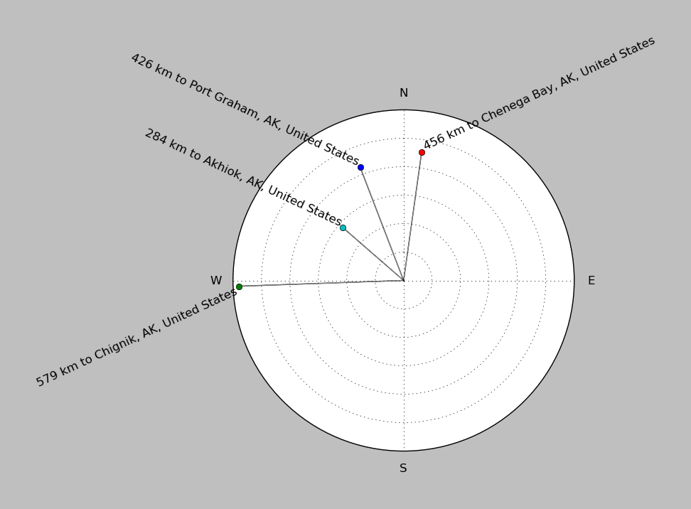
| ||||||||||||||||
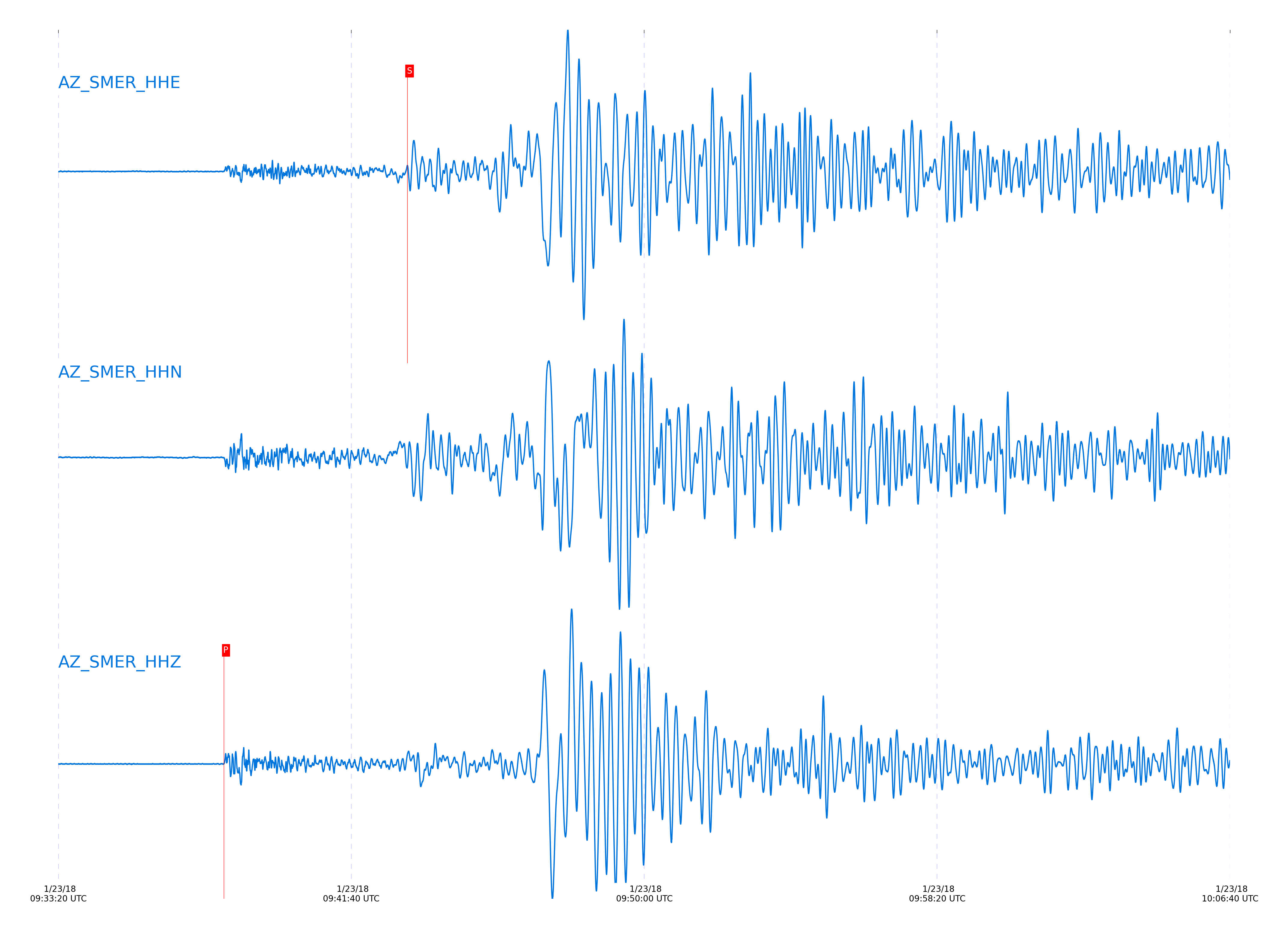
Event and active stations
|
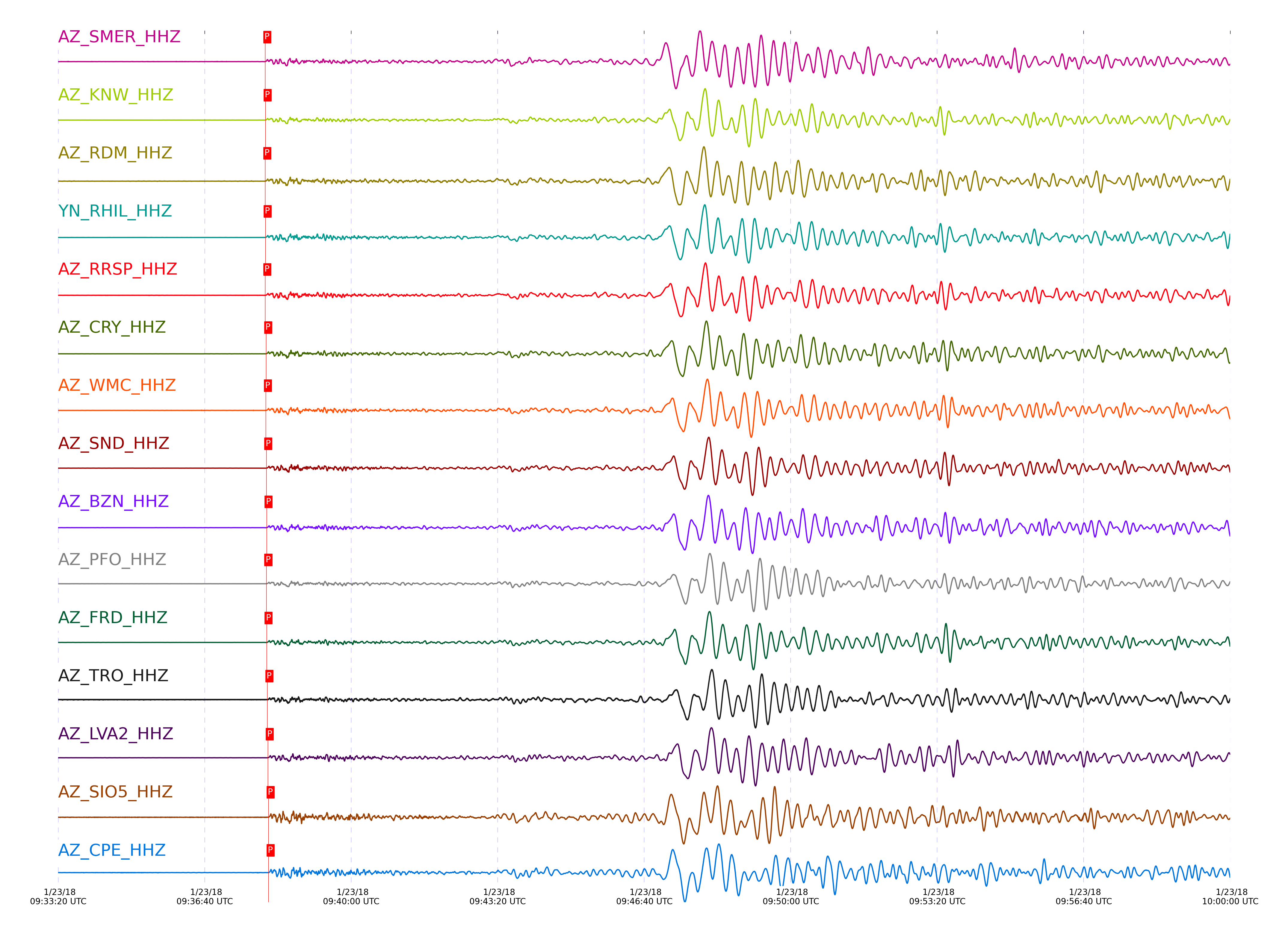
|||||||||||||||||
Closest station with identified signal. Not filtered.
Subset of several stations close to the event. Not filtered.
| STA_CHAN | S-E Delta | S-E Azimuth | Phase | Time | Signal/Noise | Time Residual | V. Model | Auth | arid |
|---|---|---|---|---|---|---|---|---|---|
| SMER_HHZ | 31.471° | 325.57° | P | 2018-01-23 09:38:02.779 UTC | -1 | 0.312 | iasp91 | dbp:jtytell:180 | 1665509 |
| SMER_HHE | 31.471° | 325.57° | S | 2018-01-23 09:43:15.7743 UTC | -1 | 5.941 | iasp91 | dbp:jtytell:180 | 1665574 |
| KNW_HHZ | 31.478° | 325.07° | P | 2018-01-23 09:38:03.1271 UTC | -1 | 0.602 | iasp91 | dbp:jtytell:180 | 1665510 |
| KNW_HHE | 31.478° | 325.07° | S | 2018-01-23 09:43:21.6455 UTC | -1 | 11.709 | iasp91 | dbp:jtytell:180 | 1665576 |
| RDM_HHZ | 31.482° | 325.23° | P | 2018-01-23 09:38:02.876 UTC | -1 | 0.312 | iasp91 | dbp:jtytell:180 | 1665511 |
| RDM_HHE | 31.482° | 325.23° | S | 2018-01-23 09:43:20.3164 UTC | -1 | 10.311 | iasp91 | dbp:jtytell:180 | 1665577 |
| RHIL_HHZ | 31.483° | 325.15° | P | 2018-01-23 09:38:03.1734 UTC | -1 | 0.602 | iasp91 | dbp:jtytell:180 | 1665512 |
| RHIL_HHN | 31.483° | 325.15° | S | 2018-01-23 09:43:13.1437 UTC | -1 | 3.125 | iasp91 | dbp:jtytell:180 | 1665578 |
| RRSP_HHZ | 31.516° | 325.15° | P | 2018-01-23 09:38:02.8905 UTC | -1 | 0.029 | iasp91 | dbp:jtytell:180 | 1665515 |
| RRSP_HHE | 31.516° | 325.15° | S | 2018-01-23 09:43:23.0074 UTC | -1 | 12.475 | iasp91 | dbp:jtytell:180 | 1665579 |
| CRY_HHZ | 31.588° | 325.23° | P | 2018-01-23 09:38:04.0053 UTC | -1 | 0.514 | iasp91 | dbp:jtytell:180 | 1665487 |
| CRY_HHE | 31.588° | 325.23° | S | 2018-01-23 09:43:21.9275 UTC | -1 | 10.277 | iasp91 | dbp:jtytell:180 | 1665581 |
| WMC_HHZ | 31.611° | 325.18° | P | 2018-01-23 09:38:03.6974 UTC | -1 | 0.004 | iasp91 | dbp:jtytell:180 | 1665518 |
| WMC_HHN | 31.611° | 325.18° | S | 2018-01-23 09:43:18.3685 UTC | -1 | 6.359 | iasp91 | dbp:jtytell:180 | 1665582 |
| SND_HHZ | 31.658° | 325.17° | P | 2018-01-23 09:38:04.2311 UTC | -1 | 0.123 | iasp91 | dbp:jtytell:180 | 1665521 |
| SND_HHN | 31.658° | 325.17° | S | 2018-01-23 09:43:19.467 UTC | -1 | 6.722 | iasp91 | dbp:jtytell:180 | 1665584 |
| BZN_HHZ | 31.682° | 325.26° | P | 2018-01-23 09:38:04.5598 UTC | -1 | 0.242 | iasp91 | dbp:jtytell:180 | 1665524 |
| PFO_HHZ | 31.682° | 325.03° | P | 2018-01-23 09:38:04.3238 UTC | -1 | 0.004 | iasp91 | dbp:jtytell:180 | 1665525 |
| PFO_HHN | 31.682° | 325.03° | S | 2018-01-23 09:43:23.7819 UTC | -1 | 10.661 | iasp91 | dbp:jtytell:180 | 1665586 |
| FRD_HHZ | 31.71° | 325.22° | P | 2018-01-23 09:38:04.6286 UTC | -1 | 0.064 | iasp91 | dbp:jtytell:180 | 1665533 |
| FRD_HHN | 31.71° | 325.22° | S | 2018-01-23 09:43:20.9498 UTC | -1 | 7.394 | iasp91 | dbp:jtytell:180 | 1665594 |
| TRO_HHZ | 31.771° | 325.09° | P | 2018-01-23 09:38:05.6363 UTC | -1 | 0.54 | iasp91 | dbp:jtytell:180 | 1665534 |
| TRO_HHN | 31.771° | 325.09° | S | 2018-01-23 09:43:22.5068 UTC | -1 | 8.008 | iasp91 | dbp:jtytell:180 | 1665595 |
| LVA2_HHZ | 31.847° | 325.33° | P | 2018-01-23 09:38:06.1877 UTC | -1 | 0.421 | iasp91 | dbp:jtytell:180 | 1665538 |
| SIO5_HHZ | 31.945° | 326.18° | P | 2018-01-23 09:38:07.284 UTC | -1 | 0.659 | iasp91 | dbp:jtytell:180 | 1665540 |
| SIO5_HHE | 31.945° | 326.18° | S | 2018-01-23 09:43:28.8224 UTC | -1 | 11.611 | iasp91 | dbp:jtytell:180 | 1665598 |
| CPE_HHZ | 31.973° | 326.05° | P | 2018-01-23 09:38:07.3482 UTC | -1 | 0.481 | iasp91 | dbp:jtytell:180 | 1665543 |
| CPE_HHN | 31.973° | 326.05° | S | 2018-01-23 09:43:23.5944 UTC | -1 | 5.952 | iasp91 | dbp:jtytell:180 | 1665601 |
| MONP2_HHZ | 32.292° | 325.66° | P | 2018-01-23 09:38:10.5018 UTC | -1 | 0.838 | iasp91 | dbp:jtytell:180 | 1665552 |
| MONP2_HHN | 32.292° | 325.66° | S | 2018-01-23 09:43:31.1777 UTC | -1 | 8.571 | iasp91 | dbp:jtytell:180 | 1665610 |
Click the link below to observe an interactive map of earthquakes recorded by the station deployment:
Broadband Seismic Data Collection Center (ANZA),
Institute of Geophysics & Planetary Physics
Scripps Institution of Oceanography,
University of California San Diego
Copyright © 1989 - 2014. All Rights Reserved.