
Magnitude 8.0 quake near New Ireland
Last updated: 2018-03-26 17:50:58 UTC
Quick Links
- Location map
- Initial source parameters
- 3 components [Anza station PFO]
- 3 components [KNET station UCH]
![3 components [Anza station PFO]](PFO_3comp.gif)
![3 components [KNET station UCH]](UCH_3comp.gif)
Translations
![]()
![]()
![]()
![]()
![]()
![]()
![]()
![]()
![]()
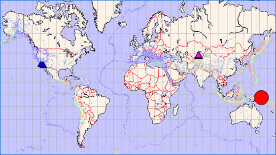
The Anza group at the University of California San Diego operates a broadband seismograph network consisting of 14 (+ 2) three component broadband seismograph stations centered near Anza California (see map). We are also partners in a 10 station broadband network, KNET, that spans the Kazakstan/Kyrgyzstan border in Central Asia.
On November 16th, 2000 shortly after 04.54 PDT we recorded an earthquake (preliminary ml 8.0) located near New Ireland. No reports as yet.
The epicentral distance (distance separating the epicenter and the recording network) for KNET is ~83.4 degrees (9283.82 km) For ANZA the distance is ~93.2 degrees (10371.88 km). This quake is considered to be a "teleseismic" event based on the epicentral distance.
This map shows the mainshock (red circle). Anza network stations are dark blue triangles. KNET network stations are pink triangles. Background seismicity is plotted in light dots with warmer colors representing deep earthquakes.
Initial source parameters:
Latitude |
Longitude |
Depth |
Origin Time (UTC) |
ms |
| -3.97 | 152.32 | 33km | 11/16/2000 (321) 04:54:56 | 8.0 |
| -5.24 | 153.06 | 33km | 11/16/2000 (321) 07:42:16 | 7.7 |
| -5.26 | 152.92 | 33km | 11/16/2000 (321) 11:05:41 | 6.2 |
You may also view a plot showing the:
- 3 component broadband recording of this quake for Anza station PFO
- 3 component broadband recording of this quake for KNET station UCH
An external
site (IRIS-DMC)
also has a page with more information about this event.
Read a brief description of the geology of the area.
Learn more about the Anza group (including who works here, station information, research, other networks, nuclear tests in China/ India/ Pakistan).
If you are interested in retrieving data for this event, please visit the IRIS-DMC for data access.
URL: http://eqinfo.ucsd.edu/special_events/2000/321/a/index.php [Last updated: 2018-03-26 17:50:58 UTC]