
Magnitude 4.4 quake near San Clemente, California
Last updated: 2018-03-26 17:50:59 UTC
Quick Links
- 3 components [closest Anza station]
- Vertical components [all Anza stations]
- Waveforms recorded at Mt. Soledad
![3 components [closest Anza station]](3comp_vert.gif)
![Vertical components [all Anza stations]](AZ_verts.gif)
Translations
![]()
![]()
![]()
![]()
![]()
![]()
![]()
![]()
![]()
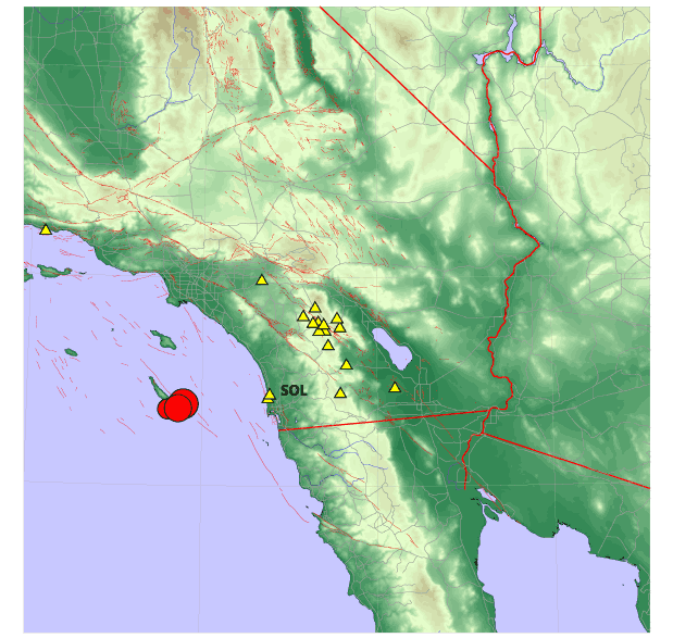
The Anza group at the University of California San Diego operates a broadband seismograph network consisting of 13 (+ 2) three component broadband seismograph stations centered near Anza Californa (see map).
On Thursday, August 16th, 2001 at 11:04:32.000 PDT we recorded an earthquake (preliminary ml 4.4) located off the coast of San Clemente Island. At 15:06:27.000 PDT we recorded a second quake (preliminary ml 4.2) located in the same area. These events were felt in the San Diego area. There have been no reports of damage.
If you felt the quake, USGS would like to know. Add to the USGS "Did you feel it?" page.
View the most recent map of local events near San Diego (this view does not show San Clemente) or view a map that shows a subset of local events near San Diego (includes San Clemente earthquakes) or a map of events recoded by ANZA from around the globe. We also have a bulletin of recent events recorded by the Anza network.
Initial source
parameters for the recent event and aftershocks are shown below.
The epicentral distance (distance separating the epicenter and
the core of the recording network) for Anza is ~0.982 degrees
(109 km). The earthquake was approximately 60 miles west of station
SOL (Mount Soledad, San Diego).
This map shows the earthquakes (red circles).
Anza network stations are yellow triangles. The station code for
our station on Mount Soledad in San Diego is SOL.
Latitude |
Longitude |
Origin time (UTC) |
Depth |
ml |
Author |
| 32.7700 | -118.23 | 8/16/2001 (228) 22:06:27.000 | 0.0 | 4.2* | SCEC |
| 32.730 | -118.390 | 8/16/2001 (228) 20:36:59.000 | 31.4 | 3.1* | SCEC |
| 32.780 | -118.210 | 8/16/2001 (228) 20:04:19.632 | 23.1 | 4.5* | UCSD |
| 32.740 | -118.270 | 8/16/2001 (228) 18:04:32.000 | 0.0 | 4.4* | SCEC |
*note that the location and magnitude determined for these events is preliminary and is subject to change upon further review of seismic data.
You may also view a plot showing
- the 3 components recorded by one of the closest Anza stations. (Station SOL is shown below.)
- the vertical components for all Anza stations
Of local interest:
We operate a broadband station on Mt. Soledad. At 8/16/2001 (228)
15:06:44.490 PDT station SOL recorded the P wave from the 4.2ml
event.
Here is a view of that event as picked by our analyst. The pink "P" indicates a P wave arrival, the "S" indicates an S wave arrival. The white lines with labels "Pg/Pn/Pb/Sg/SN/SB" indicate the predicted arrival times based on a travel time model. Each vertical dotted line devides the window into 5 second bins. The window displays ~45 seconds of data.
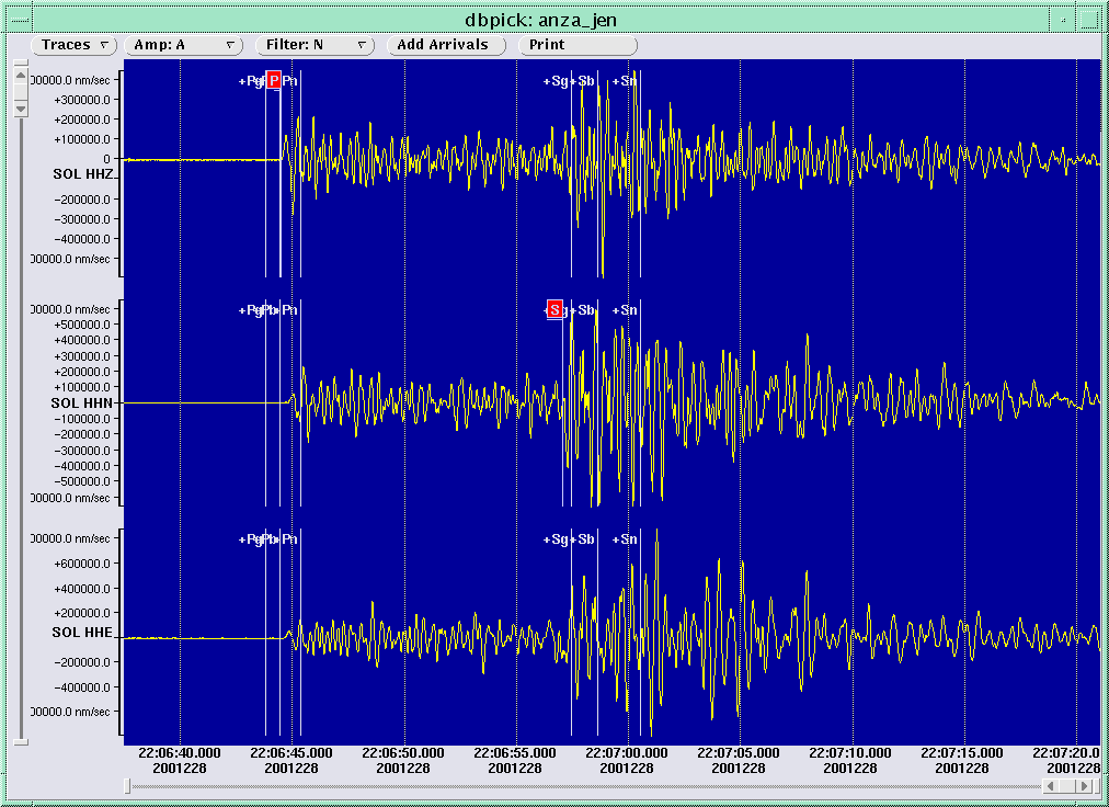
View a larger image showing the waveforms recorded at Mt. Soledad.
Learn more about the Anza group (including who works here, other networks, nuclear tests in India and Pakistan).
Learn more about the ANZA network (includes more station information, research, etc).
URL: http://eqinfo.ucsd.edu/special_events/2001/228/a/index.php [Last updated: 2018-03-26 17:50:59 UTC]