
last update to page: December 26 2016 22:15:32 (UTC).
SummaryThe red marker denotes the earthquake epicenter. On Sun Dec 25th 2016 14:22:26 (UTC) the seismic network recorded an earthquake (preliminary 7.6 mww) located in Southern Chile. Seismic region Extreme South America. The epicentral distance (i.e. distance separating the location to the epicenter) to the closest station USGCB in the network is 9,527.3 km. If you felt the quake, the USGS would like to know. Please add your comments to the USGS page "Did you feel it?". |
Details
Proximity to Population Centers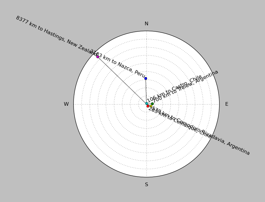
| ||||||||||||||||
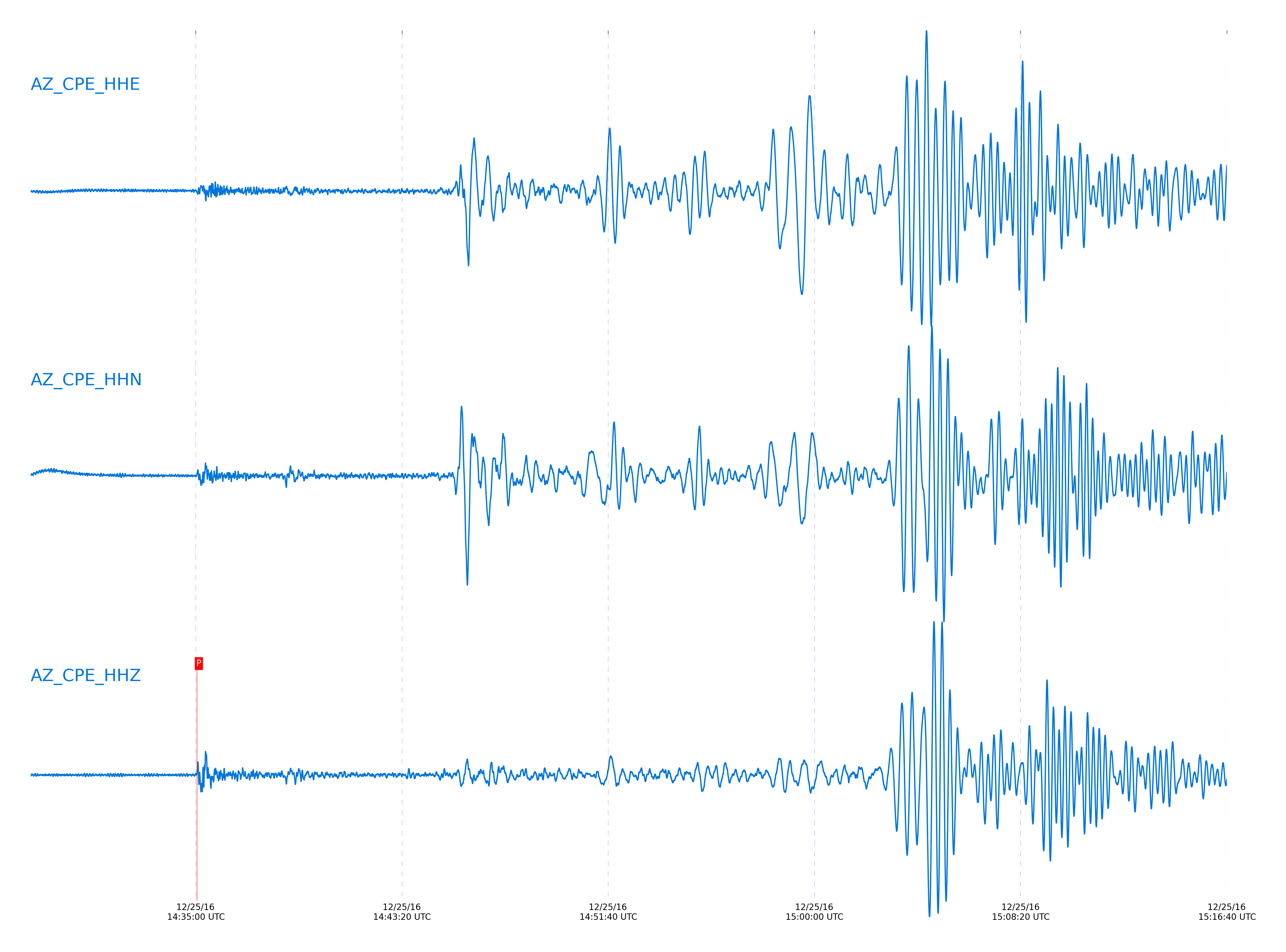
Event and active stations
|
|||||||||||||||||
Closest station with identified signal. Not filtered.
Subset of several stations close to the event. Not filtered.
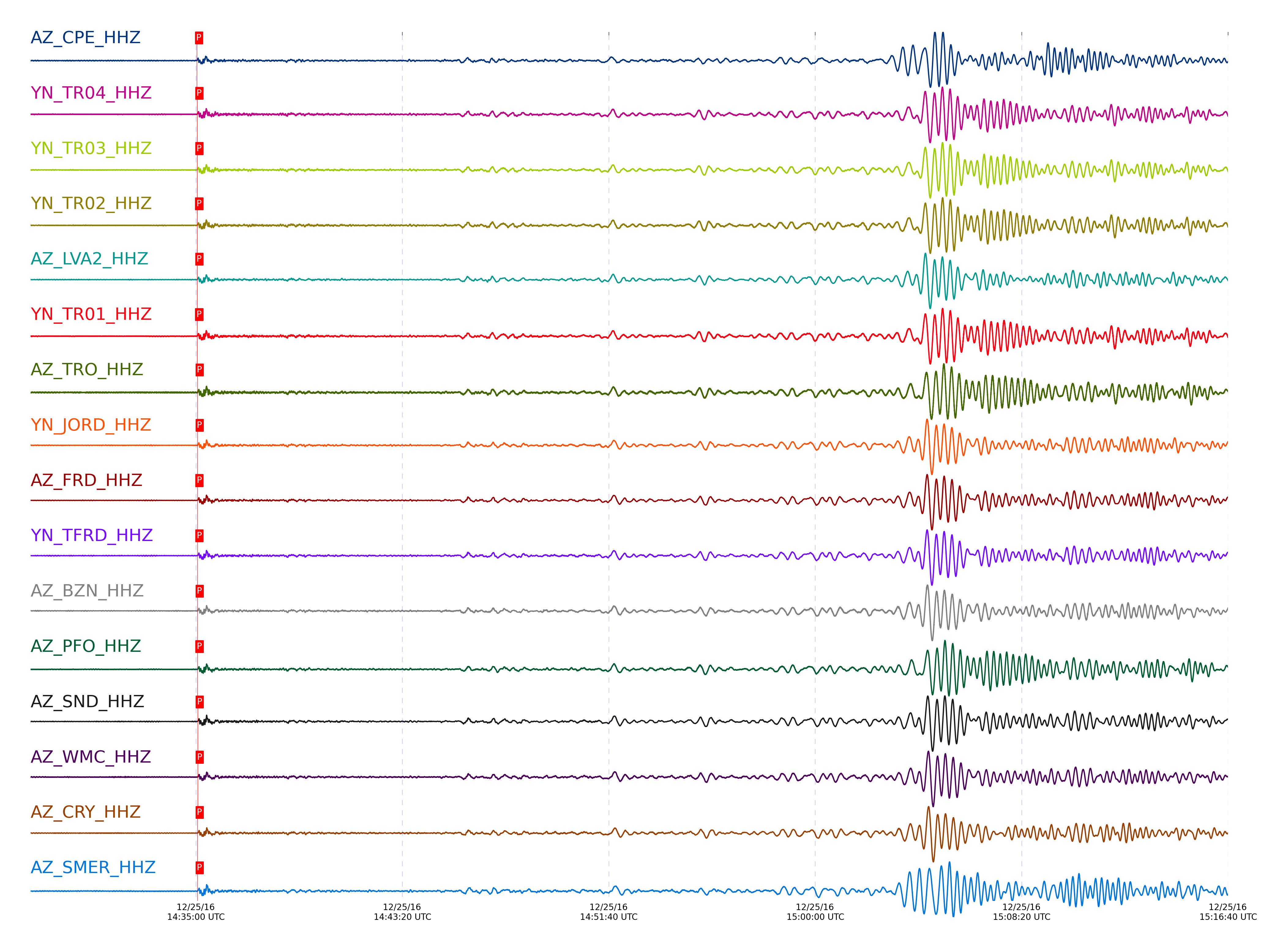
| STA_CHAN | S-E Delta | S-E Azimuth | Phase | Time | Signal/Noise | Time Residual | V. Model | Auth | arid |
|---|---|---|---|---|---|---|---|---|---|
| CPE_HHZ | 85.885° | 150.13° | P | 2016-12-25 14:35:02.7224 UTC | 13.059 | -0.159 | iasp91 | dbp:jtytell:163 | 1303832 |
| TR04_HHZ | 86.046° | 150.55° | P | 2016-12-25 14:35:03.4499 UTC | -1 | -0.229 | iasp91 | dbp:jtytell:163 | 1304988 |
| TR03_HHZ | 86.055° | 150.55° | P | 2016-12-25 14:35:03.4904 UTC | -1 | -0.229 | iasp91 | dbp:jtytell:163 | 1304989 |
| TR02_HHZ | 86.06° | 150.56° | P | 2016-12-25 14:35:03.1613 UTC | -1 | -0.583 | iasp91 | dbp:jtytell:163 | 1304990 |
| LVA2_HHZ | 86.061° | 150.47° | P | 2016-12-25 14:35:03.5928 UTC | 21.349 | -0.159 | iasp91 | dbp:jtytell:163 | 1303827 |
| TR01_HHZ | 86.062° | 150.56° | P | 2016-12-25 14:35:03.2451 UTC | 27.065 | -0.512 | iasp91 | dbp:jtytell:163 | 1303836 |
| TRO_HHZ | 86.155° | 150.55° | P | 2016-12-25 14:35:04.0548 UTC | -1 | -0.159 | iasp91 | dbp:jtytell:163 | 1305006 |
| JORD_HHZ | 86.2° | 150.42° | P | 2016-12-25 14:35:04.0666 UTC | 27.167 | -0.371 | iasp91 | dbp:jtytell:163 | 1303829 |
| FRD_HHZ | 86.202° | 150.45° | P | 2016-12-25 14:35:03.6517 UTC | 25.175 | -0.795 | iasp91 | dbp:jtytell:163 | 1303839 |
| TFRD_HHZ | 86.202° | 150.45° | P | 2016-12-25 14:35:03.7937 UTC | -1 | -0.654 | iasp91 | dbp:jtytell:163 | 1305009 |
| BZN_HHZ | 86.226° | 150.41° | P | 2016-12-25 14:35:04.1937 UTC | 30.146 | -0.371 | iasp91 | dbp:jtytell:163 | 1303828 |
| PFO_HHZ | 86.245° | 150.54° | P | 2016-12-25 14:35:03.9351 UTC | -1 | -0.725 | iasp91 | dbp:jtytell:163 | 1305016 |
| SND_HHZ | 86.256° | 150.44° | P | 2016-12-25 14:35:04.4842 UTC | 23.08 | -0.229 | iasp91 | dbp:jtytell:163 | 1303831 |
| WMC_HHZ | 86.301° | 150.41° | P | 2016-12-25 14:35:04.4896 UTC | 22.751 | -0.442 | iasp91 | dbp:jtytell:163 | 1303834 |
| CRY_HHZ | 86.319° | 150.37° | P | 2016-12-25 14:35:04.2274 UTC | 24.505 | -0.795 | iasp91 | dbp:jtytell:163 | 1303833 |
| SMER_HHZ | 86.405° | 150.11° | P | 2016-12-25 14:35:04.2247 UTC | 25.088 | -1.22 | iasp91 | dbp:jtytell:163 | 1303830 |
| RDM_HHZ | 86.421° | 150.3° | P | 2016-12-25 14:35:04.868 UTC | 28.762 | -0.654 | iasp91 | dbp:jtytell:163 | 1303841 |
| KNW_HHZ | 86.438° | 150.39° | P | 2016-12-25 14:35:05.1642 UTC | -1 | -0.442 | iasp91 | dbp:jtytell:163 | 1305021 |
Click the link below to observe an interactive map of earthquakes recorded by the station deployment:
Broadband Seismic Data Collection Center (ANZA),
Institute of Geophysics & Planetary Physics
Scripps Institution of Oceanography,
University of California San Diego
Copyright © 1989 - 2014. All Rights Reserved.