
last update to page: July 17 2017 19:00:19 (UTC).
SummaryThe red marker denotes the earthquake epicenter. On Mon Jul 17th 2017 11:05:08 (UTC) the seismic network recorded an earthquake (preliminary 6.2 mww) located in Komandorskiye Ostrova Region. Seismic region Alaska - Aleutian Arc. The epicentral distance (i.e. distance separating the location to the epicenter) to the closest station CSLB in the network is 5,977.9 km. If you felt the quake, the USGS would like to know. Please add your comments to the USGS page "Did you feel it?". |
Details
Proximity to Population Centers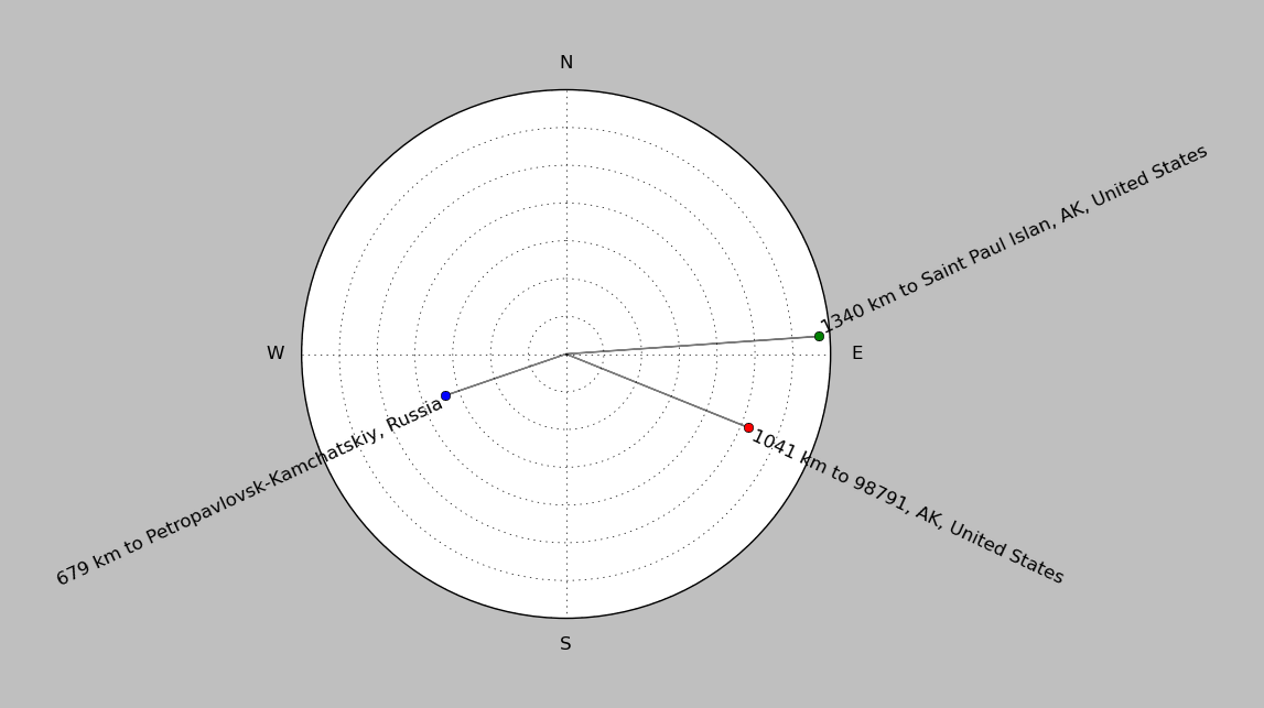
| ||||||||||||||||
Event and active stations
|
|||||||||||||||||
Closest station with identified signal. Not filtered.
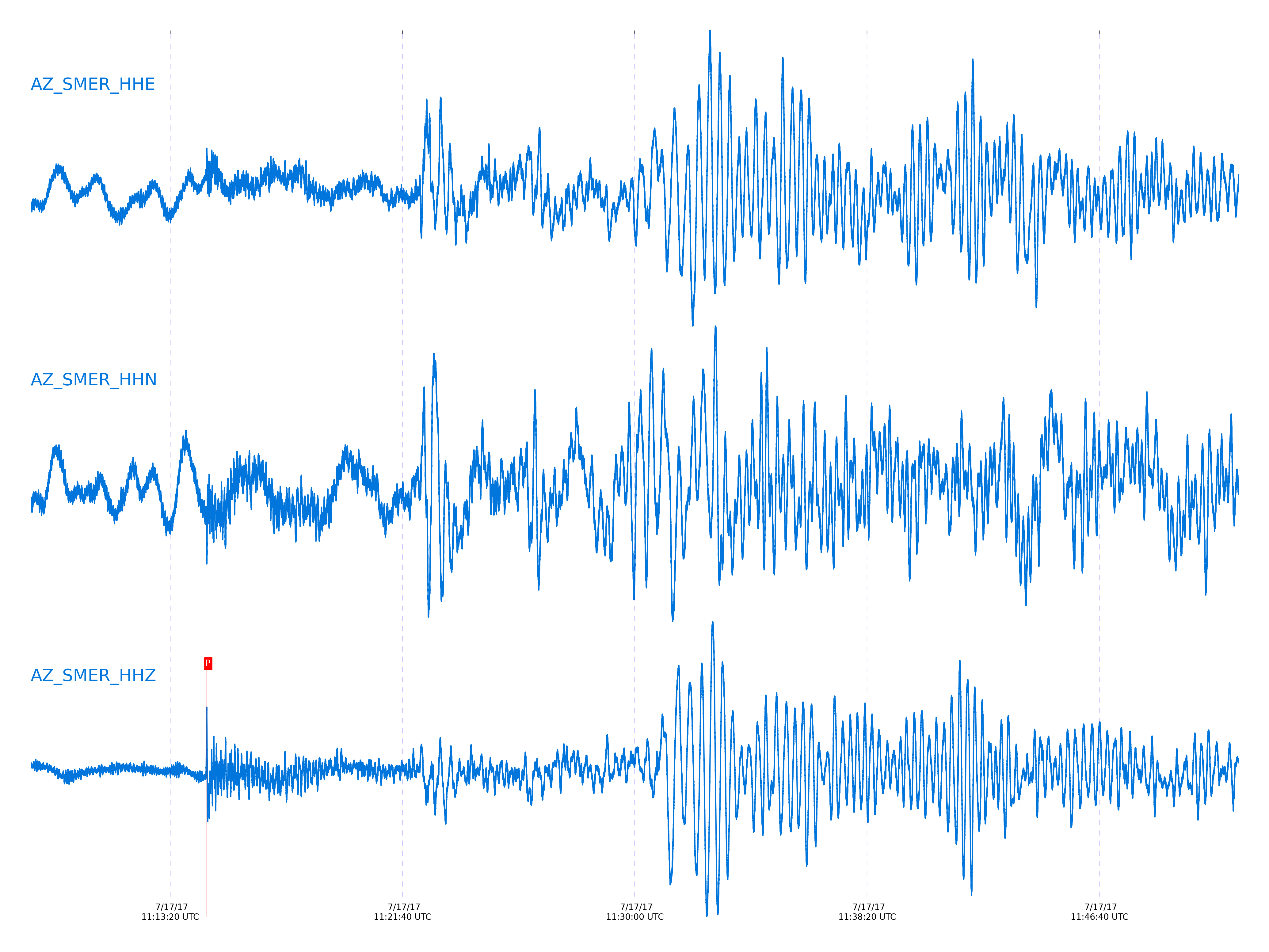
Subset of several stations close to the event. Not filtered.
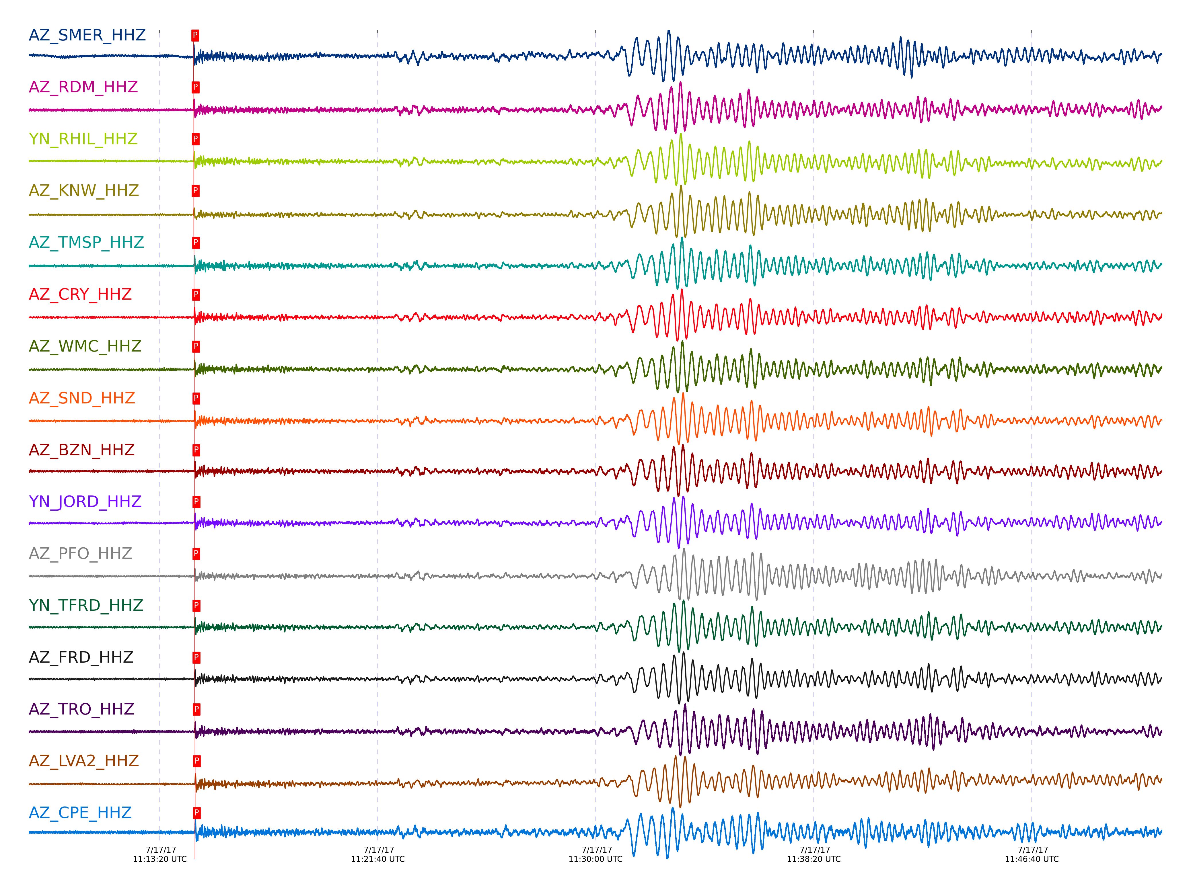
| STA_CHAN | S-E Delta | S-E Azimuth | Phase | Time | Signal/Noise | Time Residual | V. Model | Auth | arid |
|---|---|---|---|---|---|---|---|---|---|
| SMER_HHZ | 54.473° | 316.75° | P | 2017-07-17 11:14:37.4893 UTC | -1 | 0.646 | iasp91 | dbp:jtytell:171 | 1454716 |
| RDM_HHZ | 54.532° | 316.71° | P | 2017-07-17 11:14:38.2669 UTC | 42.388 | 0.994 | iasp91 | dbp:jtytell:171 | 1454503 |
| RHIL_HHZ | 54.544° | 316.7° | P | 2017-07-17 11:14:38.4552 UTC | -1 | 1.093 | iasp91 | dbp:jtytell:171 | 1454717 |
| KNW_HHZ | 54.548° | 316.68° | P | 2017-07-17 11:14:38.1872 UTC | 20.902 | 0.795 | iasp91 | dbp:jtytell:171 | 1454477 |
| TMSP_HHZ | 54.635° | 316.73° | P | 2017-07-17 11:14:39.1656 UTC | -1 | 1.143 | iasp91 | dbp:jtytell:171 | 1454721 |
| CRY_HHZ | 54.642° | 316.75° | P | 2017-07-17 11:14:39.3158 UTC | 35.14 | 1.242 | iasp91 | dbp:jtytell:171 | 1454479 |
| WMC_HHZ | 54.672° | 316.76° | P | 2017-07-17 11:14:39.4326 UTC | 38.869 | 1.143 | iasp91 | dbp:jtytell:171 | 1454481 |
| SND_HHZ | 54.723° | 316.77° | P | 2017-07-17 11:14:39.8532 UTC | 24.98 | 1.193 | iasp91 | dbp:jtytell:171 | 1454489 |
| BZN_HHZ | 54.736° | 316.8° | pP | 2017-07-17 11:14:40.0479 UTC | 36.902 | -1.235 | iasp91 | dbp:jtytell:171 | 1454491 |
| JORD_HHZ | 54.763° | 316.81° | P | 2017-07-17 11:14:40.1418 UTC | 32.675 | 1.193 | iasp91 | dbp:jtytell:171 | 1454487 |
| PFO_HHZ | 54.767° | 316.76° | P | 2017-07-17 11:14:39.7751 UTC | 20.907 | 0.795 | iasp91 | dbp:jtytell:171 | 1454485 |
| TFRD_HHZ | 54.77° | 316.8° | P | 2017-07-17 11:14:40.2492 UTC | -1 | 1.242 | iasp91 | dbp:jtytell:171 | 1454727 |
| FRD_HHZ | 54.771° | 316.8° | P | 2017-07-17 11:14:40.2001 UTC | 32.717 | 1.193 | iasp91 | dbp:jtytell:171 | 1454483 |
| TRO_HHZ | 54.85° | 316.81° | P | 2017-07-17 11:14:40.6795 UTC | 40.821 | 1.093 | iasp91 | dbp:jtytell:171 | 1454497 |
| SIO5_HHZ | 54.878° | 317.04° | P | 2017-07-17 11:14:41.0336 UTC | 9.2904 | 1.246 | iasp91 | dbp:jtytell:171 | 1454501 |
| LVA2_HHZ | 54.898° | 316.88° | pP | 2017-07-17 11:14:41.2745 UTC | 35.138 | -1.186 | iasp91 | dbp:jtytell:171 | 1454493 |
| CPE_HHZ | 54.926° | 317.04° | P | 2017-07-17 11:14:41.0258 UTC | 19.84 | 0.894 | iasp91 | dbp:jtytell:171 | 1454495 |
| TR02_HHZ | 54.932° | 316.86° | P | 2017-07-17 11:14:41.1227 UTC | -1 | 0.944 | iasp91 | dbp:jtytell:171 | 1454735 |
| TR03_HHZ | 54.935° | 316.87° | P | 2017-07-17 11:14:41.2914 UTC | -1 | 1.093 | iasp91 | dbp:jtytell:171 | 1454736 |
| TR04_HHZ | 54.941° | 316.87° | P | 2017-07-17 11:14:41.3368 UTC | -1 | 1.093 | iasp91 | dbp:jtytell:171 | 1454738 |
| MONP2_HHZ | 55.314° | 317.11° | P | 2017-07-17 11:14:43.932 UTC | -1 | 0.994 | iasp91 | dbp:jtytell:171 | 1454746 |
Click the link below to observe an interactive map of earthquakes recorded by the station deployment:
Broadband Seismic Data Collection Center (ANZA),
Institute of Geophysics & Planetary Physics
Scripps Institution of Oceanography,
University of California San Diego
Copyright © 1989 - 2014. All Rights Reserved.