
last update to page: October 23 2018 19:45:39 (UTC).
SummaryThe red marker denotes the earthquake epicenter. On Sun Jun 24th 2018 07:47:09 (UTC) the seismic network recorded an earthquake (preliminary 2.96 ml) located in Southern California. Seismic region California - Nevada Region. The epicentral distance (i.e. distance separating the location to the epicenter) to the closest station SFTR in the network is 1.3 km. If you felt the quake, the USGS would like to know. Please add your comments to the USGS page "Did you feel it?". |
Details
Proximity to Population Centers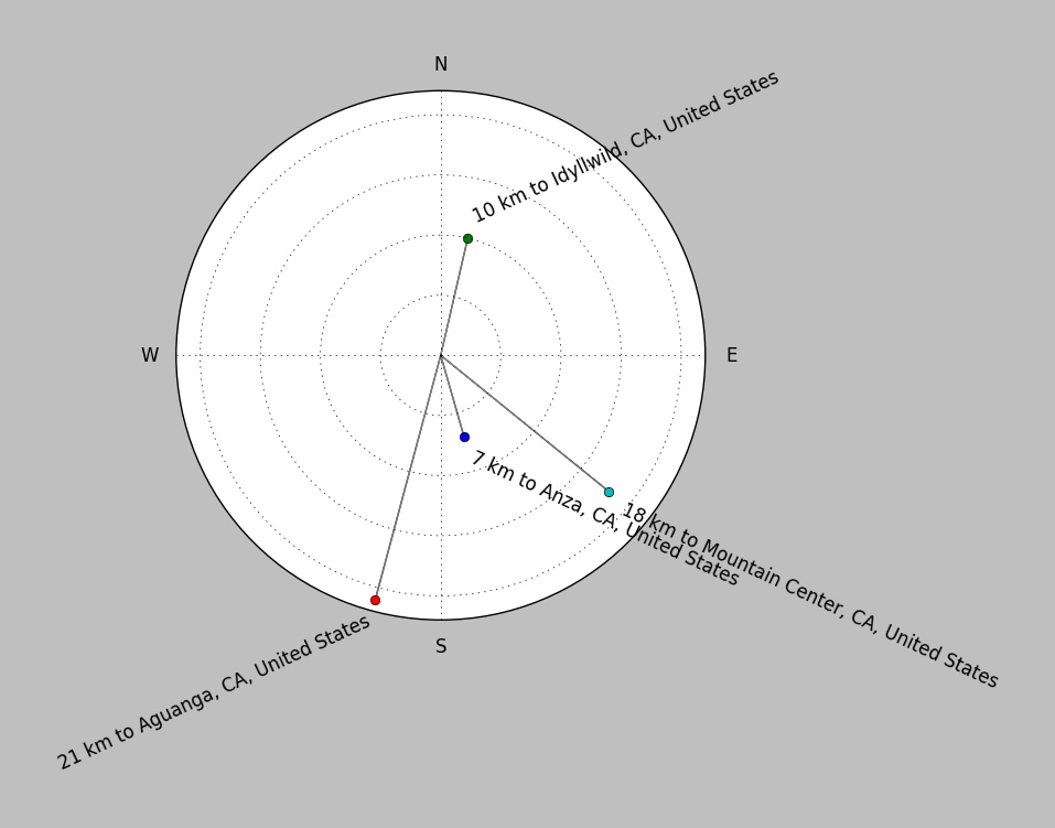
| ||||||||||||||||
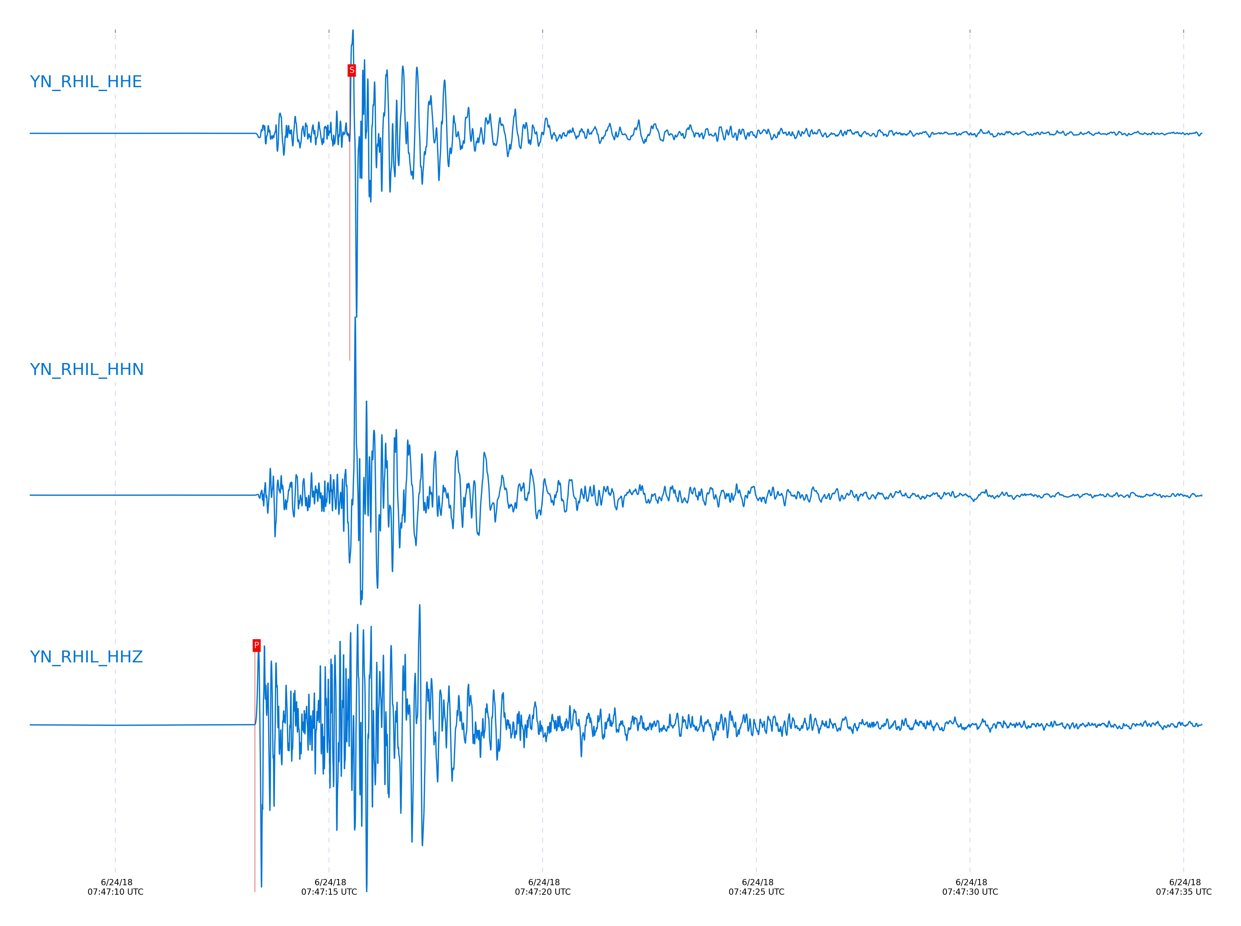
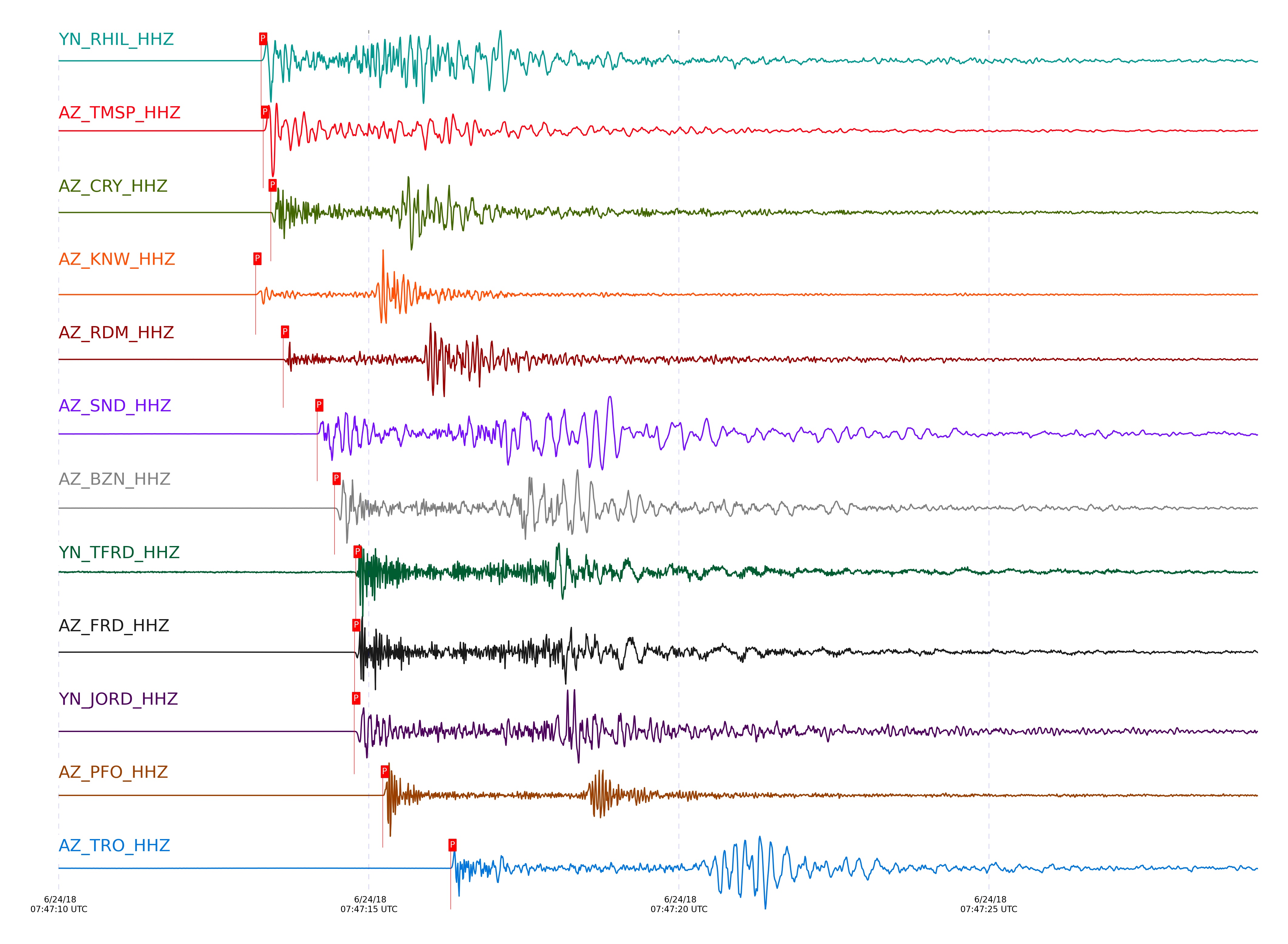
Event and active stations
|
|||||||||||||||||
Closest station with identified signal. Not filtered.
Subset of several stations close to the event. Not filtered.
| STA_CHAN | S-E Delta | S-E Azimuth | Phase | Time | Signal/Noise | Time Residual | V. Model | Auth | arid |
|---|---|---|---|---|---|---|---|---|---|
| RHIL_HHE | 0.046° | 141.17° | S | 2018-06-24 07:47:15.4836 UTC | -1 | -0.046 | iasp91 | dbp:jtytell:181 | 1799551 |
| RHIL_HHZ | 0.046° | 141.17° | P | 2018-06-24 07:47:13.2632 UTC | 6761.1 | 0.146 | iasp91 | dbp:jtytell:181 | 1797861 |
| TMSP_HHZ | 0.05° | 291.56° | P | 2018-06-24 07:47:13.2963 UTC | 3782.1 | 0.05 | iasp91 | dbp:jtytell:181 | 1797863 |
| CRY_HHZ | 0.072° | 0.26° | P | 2018-06-24 07:47:13.4184 UTC | 9790.2 | 0.212 | iasp91 | dbp:jtytell:181 | 1797865 |
| CRY_HHE | 0.072° | 0.26° | S | 2018-06-24 07:47:15.5588 UTC | -1 | -0.098 | iasp91 | dbp:jtytell:181 | 1799557 |
| KNW_HHZ | 0.079° | 195.22° | P | 2018-06-24 07:47:13.1731 UTC | 28512 | -0.152 | iasp91 | dbp:jtytell:181 | 1797860 |
| KNW_HHE | 0.079° | 195.22° | S | 2018-06-24 07:47:15.0801 UTC | -1 | -0.78 | iasp91 | dbp:jtytell:181 | 1799556 |
| RDM_HHZ | 0.093° | 85.26° | P | 2018-06-24 07:47:13.6184 UTC | 1271.6 | 0.234 | iasp91 | dbp:jtytell:181 | 1797866 |
| RDM_HHN | 0.093° | 85.26° | S | 2018-06-24 07:47:15.8721 UTC | -1 | -0.076 | iasp91 | dbp:jtytell:181 | 1799560 |
| SND_HHZ | 0.134° | 309.72° | P | 2018-06-24 07:47:14.1684 UTC | 654.31 | 0.358 | iasp91 | dbp:jtytell:181 | 1797867 |
| SND_HHN | 0.134° | 309.72° | S | 2018-06-24 07:47:17.0321 UTC | -1 | 0.316 | iasp91 | dbp:jtytell:181 | 1799562 |
| BZN_HHN | 0.157° | 338.29° | S | 2018-06-24 07:47:17.3604 UTC | -1 | 0.124 | iasp91 | dbp:jtytell:181 | 1799564 |
| BZN_HHZ | 0.157° | 338.29° | P | 2018-06-24 07:47:14.4484 UTC | 793.92 | 0.349 | iasp91 | dbp:jtytell:181 | 1797869 |
| TFRD_HHZ | 0.182° | 321.87° | P | 2018-06-24 07:47:14.7877 UTC | 34.551 | 0.401 | iasp91 | dbp:jtytell:181 | 1797872 |
| JORD_HHZ | 0.182° | 335.18° | P | 2018-06-24 07:47:14.7645 UTC | 3546.1 | 0.333 | iasp91 | dbp:jtytell:181 | 1797870 |
| FRD_HHZ | 0.182° | 321.89° | P | 2018-06-24 07:47:14.7684 UTC | 5421.2 | 0.356 | iasp91 | dbp:jtytell:181 | 1797871 |
| JORD_HHE | 0.182° | 335.18° | S | 2018-06-24 07:47:17.8966 UTC | -1 | 0.07 | iasp91 | dbp:jtytell:181 | 1799567 |
| FRD_HHE | 0.182° | 321.89° | S | 2018-06-24 07:47:17.8297 UTC | -1 | 0.037 | iasp91 | dbp:jtytell:181 | 1799566 |
| PFO_HHZ | 0.233° | 276.48° | P | 2018-06-24 07:47:15.2251 UTC | 4935.5 | 0.028 | iasp91 | dbp:jtytell:181 | 1797888 |
| PFO_HHN | 0.233° | 276.48° | S | 2018-06-24 07:47:18.5691 UTC | -1 | -0.593 | iasp91 | dbp:jtytell:181 | 1799572 |
| TRO_HHN | 0.284° | 293.86° | S | 2018-06-24 07:47:20.4793 UTC | -1 | -0.452 | iasp91 | dbp:jtytell:181 | 1799581 |
| TRO_HHZ | 0.284° | 293.86° | P | 2018-06-24 07:47:16.3184 UTC | 329.47 | 0.108 | iasp91 | dbp:jtytell:181 | 1797875 |
| LVA2_HHZ | 0.321° | 332.96° | P | 2018-06-24 07:47:17.1631 UTC | 1094.9 | 0.462 | iasp91 | dbp:jtytell:181 | 1797876 |
| SMER_HHN | 0.404° | 63.43° | S | 2018-06-24 07:47:24.1293 UTC | -1 | 0.123 | iasp91 | dbp:jtytell:181 | 1799589 |
| SMER_HHZ | 0.404° | 63.43° | P | 2018-06-24 07:47:18.3761 UTC | 308.57 | 0.34 | iasp91 | dbp:jtytell:181 | 1797877 |
| MONP2_HHZ | 0.791° | 340.65° | P | 2018-06-24 07:47:25.2284 UTC | 133.06 | -0.078 | iasp91 | dbp:jtytell:181 | 1797894 |
| CPE_HHN | 0.81° | 22.25° | S | 2018-06-24 07:47:35.5967 UTC | -1 | -1.274 | iasp91 | dbp:jtytell:181 | 1799605 |
| CPE_HHZ | 0.81° | 22.25° | P | 2018-06-24 07:47:25.0184 UTC | 75.271 | -0.437 | iasp91 | dbp:jtytell:181 | 1797892 |
| SIO5_HHZ | 0.905° | 28.15° | P | 2018-06-24 07:47:26.8594 UTC | 13.05 | -0.264 | iasp91 | dbp:jtytell:181 | 1797895 |
| SIO5_HHN | 0.905° | 28.15° | S | 2018-06-24 07:47:39.0017 UTC | -1 | -0.779 | iasp91 | dbp:jtytell:181 | 1799608 |
Click the link below to observe an interactive map of earthquakes recorded by the station deployment:
Broadband Seismic Data Collection Center (ANZA),
Institute of Geophysics & Planetary Physics
Scripps Institution of Oceanography,
University of California San Diego
Copyright © 1989 - 2014. All Rights Reserved.