
last update to page: November 07 2018 17:03:07 (UTC).
SummaryThe red marker denotes the earthquake epicenter. On Wed Aug 15th 2018 01:24:26 (UTC) the seismic network recorded an earthquake (preliminary 4.68 ml) located in Southern California. Seismic region California - Nevada Region. The epicentral distance (i.e. distance separating the location to the epicenter) to the closest station CRY in the network is 11.5 km. If you felt the quake, the USGS would like to know. Please add your comments to the USGS page "Did you feel it?". |
Details
Proximity to Population Centers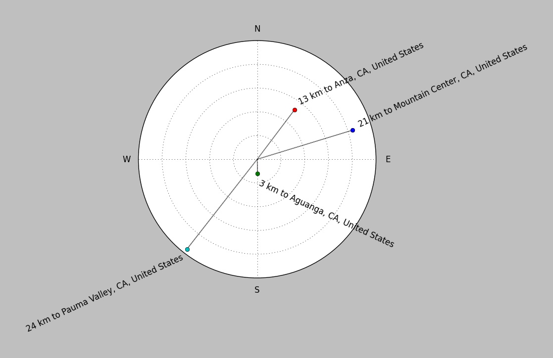
| ||||||||||||||||
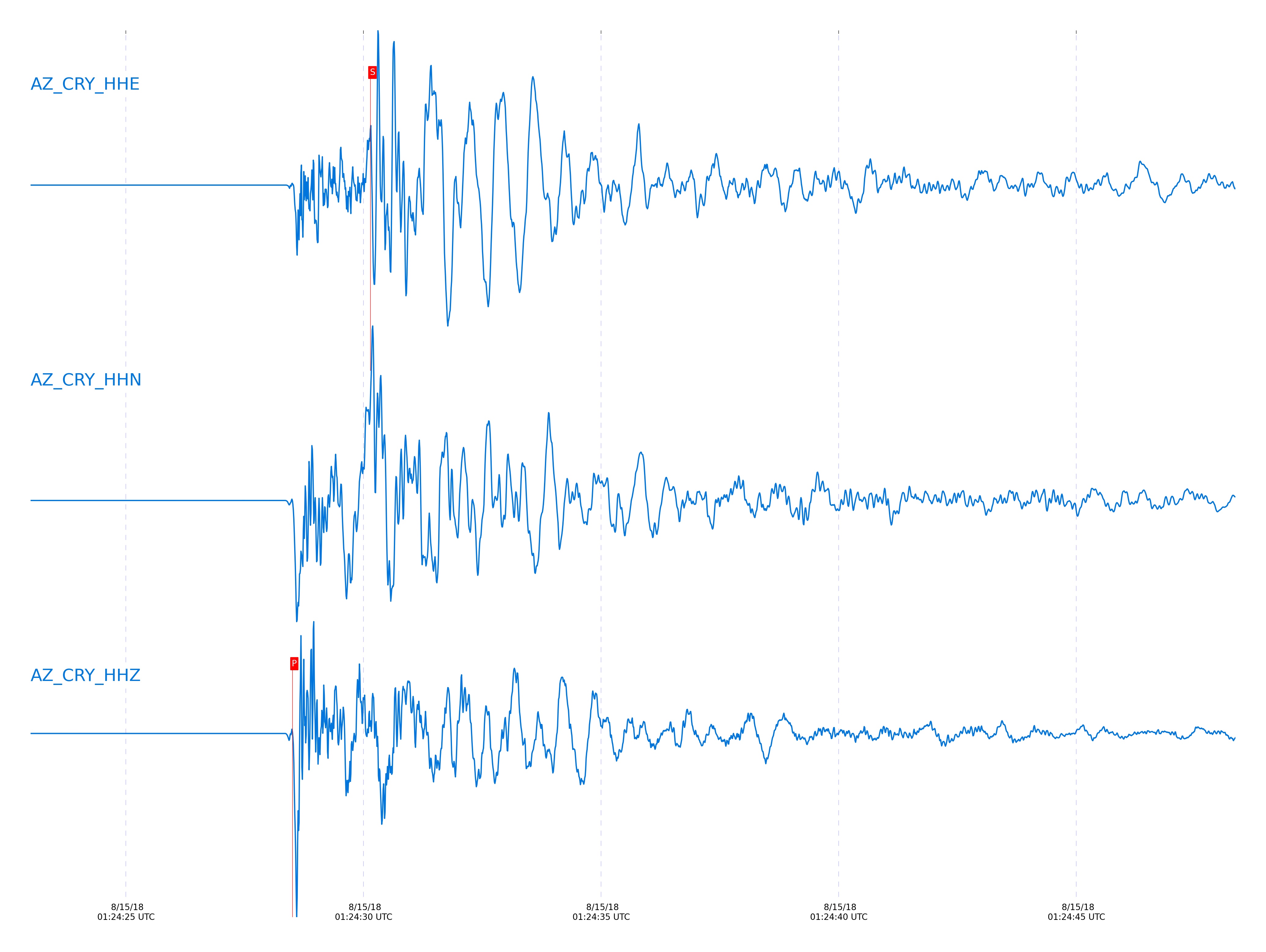
Event and active stations
|
|||||||||||||||||
Closest station with identified signal. Not filtered.
Subset of several stations close to the event. Not filtered.
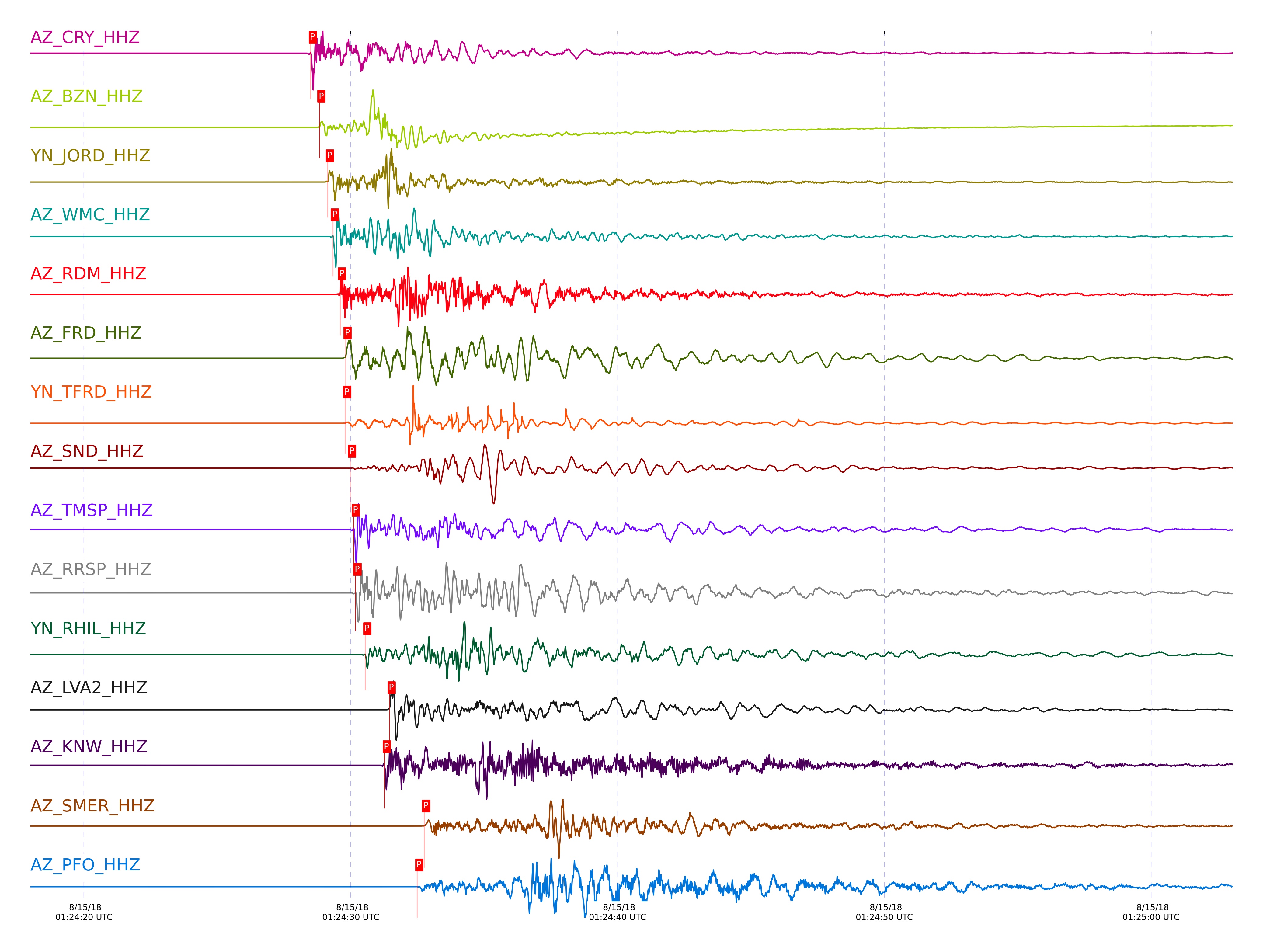
| STA_CHAN | S-E Delta | S-E Azimuth | Phase | Time | Signal/Noise | Time Residual | V. Model | Auth | arid |
|---|---|---|---|---|---|---|---|---|---|
| CRY_HHZ | 0.104° | 210.42° | P | 2018-08-15 01:24:28.5055 UTC | 61709 | -0.181 | iasp91 | dbp:jtytell:182 | 1839592 |
| CRY_HHE | 0.104° | 210.42° | S | 2018-08-15 01:24:30.1457 UTC | -1 | -0.458 | iasp91 | dbp:jtytell:182 | 1844624 |
| BZN_HHZ | 0.112° | 262.1° | P | 2018-08-15 01:24:28.8297 UTC | 35379 | -0.023 | iasp91 | dbp:jtytell:182 | 1839594 |
| BZN_HHN | 0.112° | 262.1° | S | 2018-08-15 01:24:30.509 UTC | -1 | -0.375 | iasp91 | dbp:jtytell:182 | 1844625 |
| JORD_HHZ | 0.13° | 271.73° | P | 2018-08-15 01:24:29.144 UTC | 107460 | 0.005 | iasp91 | dbp:jtytell:182 | 1839596 |
| JORD_HHN | 0.13° | 271.73° | S | 2018-08-15 01:24:30.9448 UTC | -1 | -0.412 | iasp91 | dbp:jtytell:182 | 1844627 |
| WMC_HHZ | 0.143° | 227.03° | P | 2018-08-15 01:24:29.3318 UTC | 5703.7 | -0.044 | iasp91 | dbp:jtytell:182 | 1839598 |
| WMC_HHE | 0.143° | 227.03° | S | 2018-08-15 01:24:31.3784 UTC | -1 | -0.374 | iasp91 | dbp:jtytell:182 | 1844628 |
| RDM_HHE | 0.159° | 165.54° | S | 2018-08-15 01:24:31.7123 UTC | -1 | -0.524 | iasp91 | dbp:jtytell:182 | 1844629 |
| RDM_HHZ | 0.159° | 165.54° | P | 2018-08-15 01:24:29.6024 UTC | 3763.5 | -0.06 | iasp91 | dbp:jtytell:182 | 1839600 |
| TFRD_HHZ | 0.166° | 263.56° | P | 2018-08-15 01:24:29.7917 UTC | 1446.4 | 0.049 | iasp91 | dbp:jtytell:182 | 1839604 |
| FRD_HHZ | 0.166° | 263.6° | P | 2018-08-15 01:24:29.8073 UTC | 20224 | 0.045 | iasp91 | dbp:jtytell:182 | 1839602 |
| FRD_HHE | 0.166° | 263.6° | S | 2018-08-15 01:24:32.066 UTC | -1 | -0.333 | iasp91 | dbp:jtytell:182 | 1844632 |
| TMSP_HHZ | 0.174° | 214.81° | P | 2018-08-15 01:24:30.114 UTC | 11138 | 0.098 | iasp91 | dbp:jtytell:182 | 1839608 |
| SND_HHZ | 0.174° | 244.13° | P | 2018-08-15 01:24:29.9793 UTC | 13700 | 0.063 | iasp91 | dbp:jtytell:182 | 1839606 |
| SND_HHE | 0.174° | 244.13° | S | 2018-08-15 01:24:32.5629 UTC | -1 | -0.1 | iasp91 | dbp:jtytell:182 | 1844634 |
| RRSP_HHZ | 0.183° | 196.12° | P | 2018-08-15 01:24:30.1767 UTC | 53718 | 0.072 | iasp91 | dbp:jtytell:182 | 1839610 |
| RHIL_HHZ | 0.199° | 186.97° | P | 2018-08-15 01:24:30.5452 UTC | 29223 | 0.164 | iasp91 | dbp:jtytell:182 | 1839614 |
| RHIL_HHE | 0.199° | 186.97° | S | 2018-08-15 01:24:33.553 UTC | -1 | 0.097 | iasp91 | dbp:jtytell:182 | 1844665 |
| LVA2_HHZ | 0.235° | 302.05° | P | 2018-08-15 01:24:31.4565 UTC | 80171 | 0.434 | iasp91 | dbp:jtytell:182 | 1839624 |
| KNW_HHE | 0.249° | 197.19° | S | 2018-08-15 01:24:34.656 UTC | -1 | -0.378 | iasp91 | dbp:jtytell:182 | 1844671 |
| KNW_HHZ | 0.249° | 197.19° | P | 2018-08-15 01:24:31.273 UTC | 7851.9 | -0.02 | iasp91 | dbp:jtytell:182 | 1839618 |
| SMER_HHN | 0.31° | 86.51° | S | 2018-08-15 01:24:37.2838 UTC | -1 | 0.549 | iasp91 | dbp:jtytell:182 | 1844674 |
| SMER_HHZ | 0.31° | 86.51° | P | 2018-08-15 01:24:32.7537 UTC | 2991.6 | 0.464 | iasp91 | dbp:jtytell:182 | 1839627 |
| PFO_HHN | 0.315° | 244.56° | S | 2018-08-15 01:24:36.7299 UTC | -1 | -0.356 | iasp91 | dbp:jtytell:182 | 1844677 |
| PFO_HHZ | 0.315° | 244.56° | P | 2018-08-15 01:24:32.4953 UTC | -1 | 0.013 | iasp91 | dbp:jtytell:182 | 1844530 |
| TRO_HHZ | 0.316° | 261.48° | P | 2018-08-15 01:24:32.6484 UTC | 2627.1 | -0.001 | iasp91 | anza | 1839629 |
| CPE_HHZ | 0.64° | 23.41° | P | 2018-08-15 01:24:38.2884 UTC | 958.8 | -0.245 | iasp91 | dbp:jtytell:182 | 1839633 |
| MONP2_HHZ | 0.664° | 331.67° | P | 2018-08-15 01:24:39.1784 UTC | 1895.5 | 0.011 | iasp91 | dbp:jtytell:182 | 1839634 |
| MONP2_HHN | 0.664° | 331.67° | S | 2018-08-15 01:24:48.0636 UTC | -1 | -0.577 | iasp91 | dbp:jtytell:182 | 1844744 |
| SIO5_HHZ | 0.738° | 30.52° | P | 2018-08-15 01:24:40.3729 UTC | 29.641 | -0.039 | iasp91 | dbp:jtytell:182 | 1839636 |
Click the link below to observe an interactive map of earthquakes recorded by the station deployment:
Broadband Seismic Data Collection Center (ANZA),
Institute of Geophysics & Planetary Physics
Scripps Institution of Oceanography,
University of California San Diego
Copyright © 1989 - 2014. All Rights Reserved.