
last update to page: March 15 2016 21:30:38 (UTC).
SummaryThe red marker denotes the earthquake epicenter. On Wed Sep 16th 2015 16:10:47 (UTC) the seismic network recorded an earthquake (preliminary 4.01 mw) located in Southern California. Seismic region California - Nevada Region. The epicentral distance (i.e. distance separating the location to the epicenter) to the closest station WRDG in the network is 46.9 km. If you felt the quake, the USGS would like to know. Please add your comments to the USGS page "Did you feel it?". |
Details
Proximity to Population Centers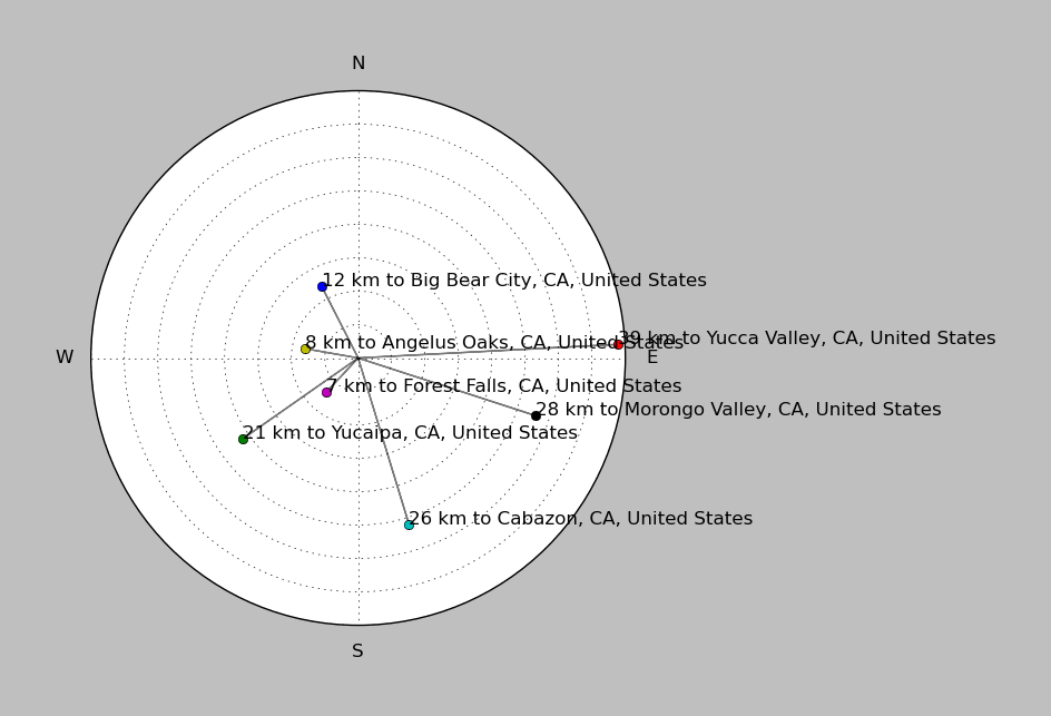
| ||||||||||||||||
Event and active stations
|
|||||||||||||||||
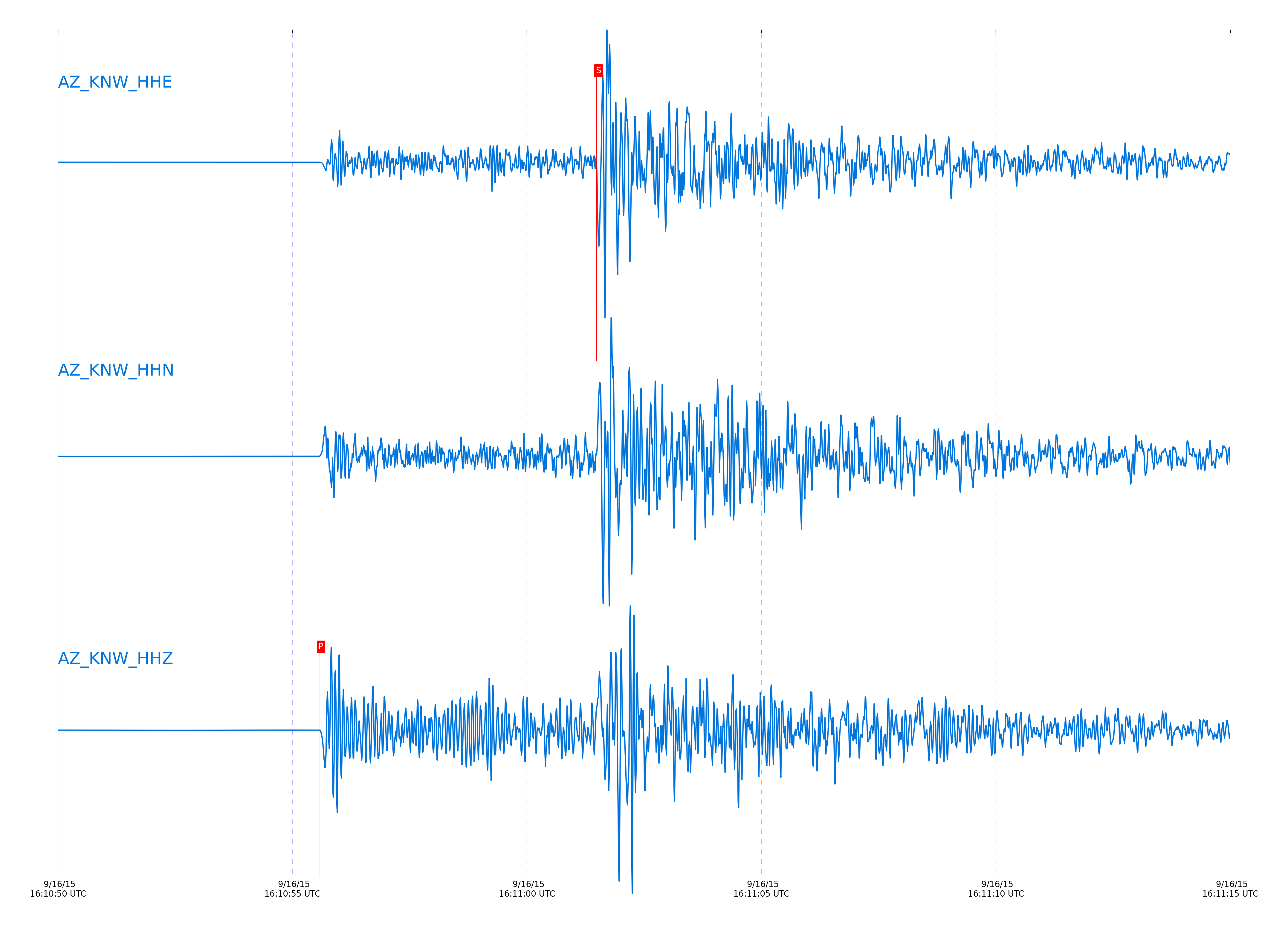
Closest station with identified signal. Not filtered.
Subset of several stations close to the event. Not filtered.
| STA_CHAN | S-E Delta | S-E Azimuth | Phase | Time | Signal/Noise | Time Residual | V. Model | Auth | arid |
|---|---|---|---|---|---|---|---|---|---|
| KNW_HHZ | 0.441° | 344.23° | Pg | 2015-09-16 16:10:55.5684 UTC | 8047.5 | -0.433 | iasp91 | dbp:jtytell:152 | 770555 |
| KNW_HHE | 0.441° | 344.23° | Sg | 2015-09-16 16:11:01.4824 UTC | -1 | -0.83 | iasp91 | dbp:jtytell:152 | 770611 |
| GVAR1_HHN | 0.489° | 345.26° | Sg | 2015-09-16 16:11:02.9383 UTC | -1 | -0.908 | iasp91 | dbp:jtytell:152 | 770625 |
| BCCC_HHZ | 0.493° | 355.56° | Pg | 2015-09-16 16:10:56.55 UTC | 2255.4 | -0.429 | iasp91 | dbp:jtytell:152 | 770559 |
| BCCC_HHN | 0.493° | 355.56° | Sg | 2015-09-16 16:11:03.196 UTC | -1 | -0.804 | iasp91 | dbp:jtytell:152 | 770626 |
| RRSP_HHZ | 0.497° | 348.72° | Pg | 2015-09-16 16:10:56.7194 UTC | -1 | -0.327 | iasp91 | dbp:jtytell:152 | 770562 |
| RRSP_HHN | 0.497° | 348.72° | Sg | 2015-09-16 16:11:03.647 UTC | -1 | -0.468 | iasp91 | dbp:jtytell:152 | 770630 |
| RDM_HHZ | 0.509° | 359.16° | Pg | 2015-09-16 16:10:56.8501 UTC | 823.35 | -0.42 | iasp91 | dbp:jtytell:152 | 770563 |
| RDM_HHN | 0.509° | 359.16° | Sg | 2015-09-16 16:11:03.735 UTC | -1 | -0.767 | iasp91 | dbp:jtytell:152 | 770632 |
| TMSP_HHN | 0.54° | 344.35° | Sg | 2015-09-16 16:11:05.0528 UTC | -1 | -0.454 | iasp91 | dbp:jtytell:152 | 770637 |
| TMSP_HHZ | 0.54° | 344.35° | Pg | 2015-09-16 16:10:57.5256 UTC | -1 | -0.327 | iasp91 | dbp:jtytell:152 | 770565 |
| CRY_HHN | 0.582° | 350.21° | Sg | 2015-09-16 16:11:05.9213 UTC | -1 | -0.96 | iasp91 | dbp:jtytell:152 | 770642 |
| CRY_HHZ | 0.582° | 350.21° | Pg | 2015-09-16 16:10:58.1937 UTC | 4809.5 | -0.456 | iasp91 | dbp:jtytell:152 | 770573 |
| WMC_HHZ | 0.585° | 345.07° | Pg | 2015-09-16 16:10:58.2692 UTC | 517.01 | -0.44 | iasp91 | dbp:jtytell:152 | 770575 |
| WMC_HHN | 0.585° | 345.07° | Sg | 2015-09-16 16:11:06.1744 UTC | -1 | -0.809 | iasp91 | dbp:jtytell:152 | 770643 |
| SND_HHZ | 0.621° | 341.02° | Pg | 2015-09-16 16:10:58.9029 UTC | 4191.2 | -0.483 | iasp91 | dbp:jtytell:152 | 770588 |
| PFO_HHZ | 0.622° | 328.06° | Pg | 2015-09-16 16:10:58.7084 UTC | 93.146 | -0.696 | iasp91 | dbp:jtytell:152 | 770582 |
| BZN_HHZ | 0.666° | 346.36° | Pg | 2015-09-16 16:10:59.7261 UTC | 2087.1 | -0.519 | iasp91 | dbp:jtytell:152 | 770591 |
| BZN_HHN | 0.666° | 346.36° | Sg | 2015-09-16 16:11:08.5695 UTC | -1 | -1.062 | iasp91 | dbp:jtytell:152 | 770656 |
| TFRD_HHZ | 0.678° | 341.88° | Pg | 2015-09-16 16:10:59.9266 UTC | -1 | -0.538 | iasp91 | dbp:jtytell:152 | 770597 |
| FRD_HHZ | 0.678° | 341.89° | Pg | 2015-09-16 16:10:59.8884 UTC | 5091.8 | -0.578 | iasp91 | dbp:jtytell:152 | 770595 |
| FRD_HHN | 0.678° | 341.89° | Sg | 2015-09-16 16:11:08.9328 UTC | -1 | -1.082 | iasp91 | dbp:jtytell:152 | 770659 |
| TFRD_HHN | 0.678° | 341.88° | Sg | 2015-09-16 16:11:09.0324 UTC | -1 | -0.979 | iasp91 | dbp:jtytell:152 | 770660 |
| JORD_HHN | 0.689° | 345.27° | Sg | 2015-09-16 16:11:09.2986 UTC | -1 | -1.092 | iasp91 | dbp:jtytell:152 | 770663 |
| JORD_HHZ | 0.689° | 345.27° | Pg | 2015-09-16 16:11:00.1047 UTC | 1551.5 | -0.58 | iasp91 | dbp:jtytell:152 | 770599 |
| TRO_HHZ | 0.712° | 329.92° | Pg | 2015-09-16 16:11:00.4784 UTC | 519.01 | -0.634 | iasp91 | dbp:jtytell:152 | 770604 |
| SMER_HHE | 0.729° | 20.88° | Sg | 2015-09-16 16:11:09.9824 UTC | -1 | -1.714 | iasp91 | dbp:jtytell:152 | 770667 |
| SMER_HHZ | 0.729° | 20.88° | Pg | 2015-09-16 16:11:00.4471 UTC | 315.75 | -0.994 | iasp91 | dbp:jtytell:152 | 770603 |
| TR01_HHZ | 0.805° | 332.89° | Pg | 2015-09-16 16:11:02.3369 UTC | 3575.6 | -0.543 | iasp91 | dbp:jtytell:152 | 770619 |
| TR02_HHZ | 0.808° | 333.21° | Pg | 2015-09-16 16:11:02.387 UTC | -1 | -0.547 | iasp91 | dbp:jtytell:152 | 770620 |
| JFN4_HHZ | 0.808° | 332.17° | Pg | 2015-09-16 16:11:02.2578 UTC | -1 | -0.685 | iasp91 | dbp:jtytell:152 | 770616 |
| JFS4_HHZ | 0.809° | 332.4° | Pg | 2015-09-16 16:11:02.2982 UTC | -1 | -0.662 | iasp91 | dbp:jtytell:152 | 770618 |
| TR03_HHZ | 0.813° | 333.82° | Pg | 2015-09-16 16:11:02.405 UTC | -1 | -0.633 | iasp91 | dbp:jtytell:152 | 770621 |
| TR04_HHZ | 0.822° | 334.29° | Pg | 2015-09-16 16:11:02.6692 UTC | -1 | -0.532 | iasp91 | dbp:jtytell:152 | 770623 |
| LVA2_HHN | 0.825° | 342.76° | Sg | 2015-09-16 16:11:13.4636 UTC | -1 | -1.351 | iasp91 | dbp:jtytell:152 | 770677 |
| LVA2_HHZ | 0.825° | 342.76° | Pg | 2015-09-16 16:11:02.6531 UTC | 2049.9 | -0.596 | iasp91 | dbp:jtytell:152 | 770622 |
| CPE_HHZ | 1.267° | 9.34° | Pn | 2015-09-16 16:11:09.3722 UTC | 135.02 | -1.563 | iasp91 | dbp:jtytell:152 | 770664 |
| CPE_HHE | 1.267° | 9.34° | Sb | 2015-09-16 16:11:25.4484 UTC | -1 | -3.16 | iasp91 | dbp:jtytell:152 | 770689 |
| MONP2_HHZ | 1.298° | 343.92° | Pn | 2015-09-16 16:11:10.6084 UTC | 390.55 | -0.759 | iasp91 | dbp:jtytell:152 | 770668 |
| SOL_HHN | 1.338° | 14° | Sn | 2015-09-16 16:11:28.2344 UTC | -1 | -2.254 | iasp91 | dbp:jtytell:152 | 770691 |
| SCI2_HHZ | 1.829° | 47.57° | Pn | 2015-09-16 16:11:17.8499 UTC | 26.237 | -0.82 | iasp91 | dbp:jtytell:152 | 770683 |
Click the link below to observe an interactive map of earthquakes recorded by the station deployment:
Broadband Seismic Data Collection Center (ANZA),
Institute of Geophysics & Planetary Physics
Scripps Institution of Oceanography,
University of California San Diego
Copyright © 1989 - 2014. All Rights Reserved.